

MT HOOD SNOW FORECAST
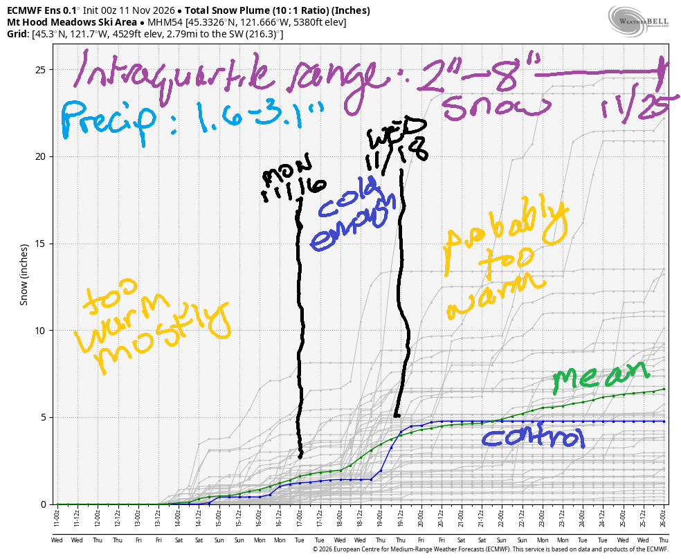
Hey skiers and snowboarders! Snow and rain alternate this week, and then we fall into a cooler pattern for the first half of next week. While the cool temps are promising, moisture won’t be plentiful, and temps are likely to rise again by the latter half of the week. Through the 23rd, the intraquartile range (25th to 75th percentile) is only 2-8” of snow on Mt. Hood. I see dryland training in your future! Weights, baby, weights!
Wednesday and Thursday look warm and partly cloudy with the freezing level around 11,000′ – better suited to hiking than shredding snow. Friday brings rain during the day with mostly dry weather and falling temps overnight. The snow level will be 8000′ during the day and will slowly fall to 5000′ after midnight. About half an inch of rain is forecast followed by a trace of snow. Wind: S20-40 all day becoming WSW 20-25 after midnight.
Saturday brings a couple inches of snow during the day with the snow level around 5000′. Overnight into Sunday, the snow level rises to 8500′, and the snow turns to rain. Wind: WSW 20-25 all day becoming SW 25-40 overnight. Half an inch of rain is forecast on Sunday, after which the snow level falls to 4000′(ish) for a few days. Not much moisture is forecast in those few days, and temps are expected to rise again for the latter half of next week. Patience, my friends! Snow will come!

GORGE WIND FORECAST
If you’re still seeing yesterday’s and it’s after 9am, try opening this in an incognito window AND/OR FLUSHING YOUR CACHE or do a do a hard refresh (Ctrl+Shift+R / Cmd+Shift+R)
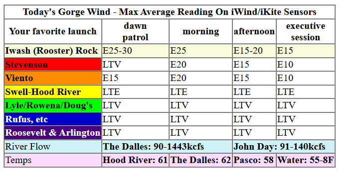
Keep in mind that this forecast attempts to predict what the iKite/iWind sensors will read. Think like a local! All sensors are not equal. Swell reads low. Viento/Arlington/The Wall read high compared to Swell. 30mph at Rufus (The Wall sensor) is about 23-24mph at Swell. 30mph at Swell is about 35-37mph at Rufus/Viento/Arlington. Hope that helps!
SHORT-TERM gorge wind forecast

Hi friends! Not much is going on in the Gorge wind forecast this week. Thanks to offshore low pressure, we’ll have easterlies, but they’re not the easterlies you’re looking for: these easterlies will, at times, be quite wet, and they won’t have the power of easterlies that tap into the support of desert high pressure. It’s just too warm out there in the Columbia Basin!
On Wednesday, we’ll see easterlies at 20mph or so at Stevenson, Iwash/Rooster, and Viento for a few hours this morning. Afternoon wind fades. Iwash ends the day at 15mph, and Stevenson/Viento at 10mph. River flow over the last 24 hours was 90-143kcfs, river temp is 55.8F, and high temp forecast is 61F and partly cloudy.
RIVER FLOW FOR SITES BETWEEN AVERY (EAST OF THE DALLES) AND RUFUS: CLICK HERE FOR JOHN DAY DAM FLOW.
RIVER FLOW FOR SITES BETWEEN STEVENSON AND DOUG’S BEACH (WEST OF THE DALLES): CLICK HERE FOR THE DALLES DAM FLOW

LONGER-TERM gorge wind forecast
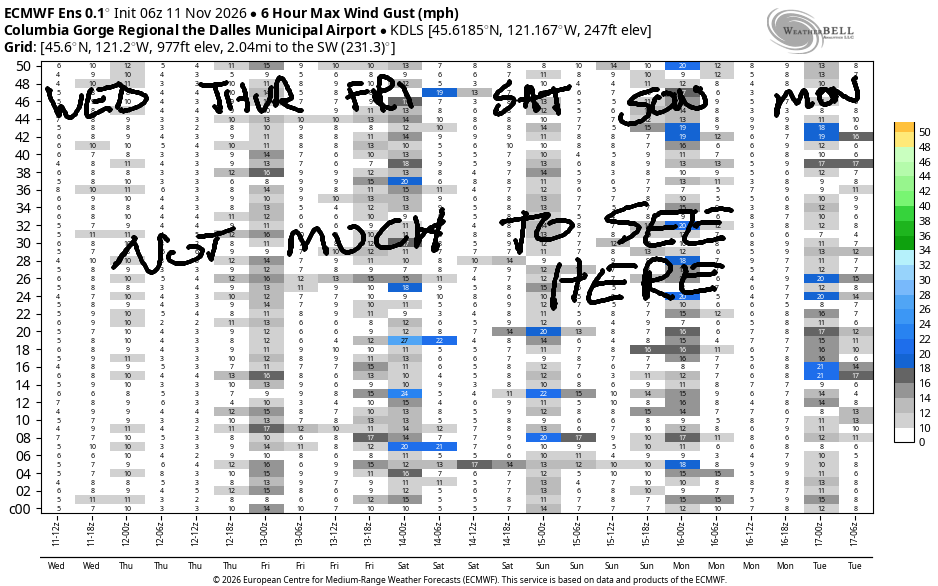
Thursday’s easterlies will be about the same as Wednesday’s: peak wind at 25mph for a few hours in the morning. Afternoon sees 20mph at Iwash/Rooster and 15mph at Stevenson and Viento. High temp: 59F and partly to mostly cloudy.
On Friday, we’ll have stronger easterlies, 30-35mph, for a few hours prior to 10am. After that: heavy rain and lighter easterlies. The Stevenson-Viento stretch (but not the Hatch, and nowhere else either) might even turn westerly at very gusty 15-20mph for a couple hours mid-afternoon before quickly turning light/variable again. High temp: 56. Saturday and Sunday may bring westerlies at 15mph or so from Arlington eastward, but the wind will be light elsewhere. That’s all I’ve got for you. I believe the 2nd Street Stairs are calling your name! See you on the Nch’i Wana one of these days!
Tip via venmo, cash or check
Want to subscribe to the email version, support Temira, and get the forecast earlier? Click on the blue box up above or use the methods below. Year-round is $29.99 or more if you think it’s worth more. Only need snow or only need wind? Warm season (May-Oct) or cold season (Nov-Apr) is $19.99 or more if you think it’s worth more. Thanks for your support!

BARE BONES HOOD RIVER WEATHER FORECAST
Cloudy this morning and partly cloudy later. Temps start near 50 and rise to the low 60s. Light easterlies. No rainbows. Thursday will be mostly cloudy then partly cloudy. Temps start in the low 40s and rise to the upper 50s. Light easterlies. No rainbows. Friday will be rainy. Temps start near 40 and rise to the mid 50s. Light and variable wind. 11% chance of rainbows.
BIKE TRAILS INFO
NEXT WORK PARTY: Unknown
CLOSED TRAILS: Anything south of the 44 Road due to the Grasshopper Fire / Forest Closure Order: for example – Boulder Lakes, Gunsight, Gumjuwac, Lookout Mountain, 450, Fifteenmile.
TEMIRA’S AWESOME TRAVEL ADVISORY SERVICE
HYPERLOCAL WEATHER FORECAST FOR THE COLUMBIA GORGE
THE DALLES, HOOD RIVER, WHITE SALMON, TROUT LAKE, STEVENSON, CASCADE LOCKS, PARKDALE, ODELL, HUSUM, BZ, MILL A, WILLARD, GOLDENDALE, RUFUS, ARLINGTON, boardman
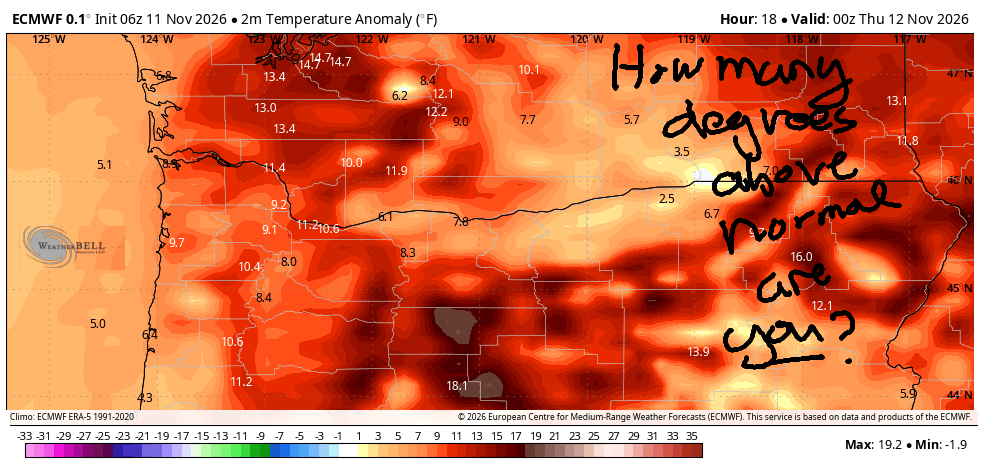
Good morning, neighbors! Today is Wednesday, and we’re staring down the barrel of yet another unseasonably warm November day. Unseasonably warm weather continues through Sunday, at least, when we’ll still be five degrees above normal. That’s very unreasonable for November. November should be cold enough and wet enough to remind everyone who doesn’t live in the Gorge why they don’t live in the Gorge! Cooler weather arrives next week, but it still doesn’t look cold enough to motivate TATAS to put their snow tires on. A couple periods of heavy rain are forecast for the city-Gorge commute zone in the next five days: Friday morning and Sunday morning. Plan around them if you can!
Wednesday started out with no known troubles, weather-wise, which should give you energy to fight for the things you care about! It must have been a heck of a sunrise away from the Nothing, because the Nothing was glowing a deep pink-purple around 6:49am. Glenwood was a balmy 43 degrees to start the day. Temps were even warmer at the ski areas – Meadows was reporting 47 degrees at 6540′! Today’s Gorge weather forecast is for partly cloudy sky and highs from 58-62 degrees in the lowlands. Even the wind is uneventful, although it will be enough to drive the naturalists away from Iwash Rock Beach: 20-25mph this morning and 10-15mph this afternoon. Same at Stevenson. To the east: light wind. Thursday looks very similar, so TATAS will not repeat themselves.
Our first travel weather concern arrives on Friday: moderate to heavy rain west of Wyeth by 7am with heavy rain to Hood River by 10am and moderate rain to Biggs starting around 1pm. Rain lets up mid-afternoon for areas west of Hood River, and light rain continues into the evening east of Hood River. If you wake up early, you’ll find temps around 40 degrees. If you make it to peak heating (whatever time that is), you’ll find 56-61 degrees, once again well above normal. Morning commuters will find easterlies at 30-35mph near Iwash Rock and Stevenson for a couple hours. By afternoon, the wind turns light/variable along the Nch’i Wana. In South Wasco County, we’re expecting south wind at 30mph.
Showery weather is forecast on Saturday with highs 56-60 degrees. Quite a bit of uncertainty is present on Sunday, but at least some scenarios contain a period of very heavy rain in the morning. It’s worth mentioning that the snow level will remain above 4000′ through Saturday, but it will drop to 4000′ or less by next Monday morning, which puts the passes at risk for wintry conditions. That said, there’s very little snow in the forecast at pass level or for the ski resorts during that period of cooler weather early next week. There’s also a good chance the weather will be dry for the first half of next week. That’s enough for now, don’t you think? TATAS thinks so. Signing off. Safe travels. -TATAS
HEY! DON’T STOP READING! Is this community-focused forecast helpful to you? It sure is! It takes me a couple hours a day to write. Please join your friends and neighbors in contributing to keep it going. Venmo: @thegorgeismygym PayPal: twomirrors@gmail.com USPS: Temira / PO Box 841 / Hood River, Oregon 97031
JONES BEACH, SAUVIE ISLAND, & COAST FORECAST
ON WINTER VACATION UNLESS DESPERATELY NEEDED.

Leave a Reply