

GORGE WIND FORECAST
If you’re still seeing yesterday’s and it’s after 9am, try opening this in an incognito window AND/OR FLUSHING YOUR CACHE or do a do a hard refresh (Ctrl+Shift+R / Cmd+Shift+R)
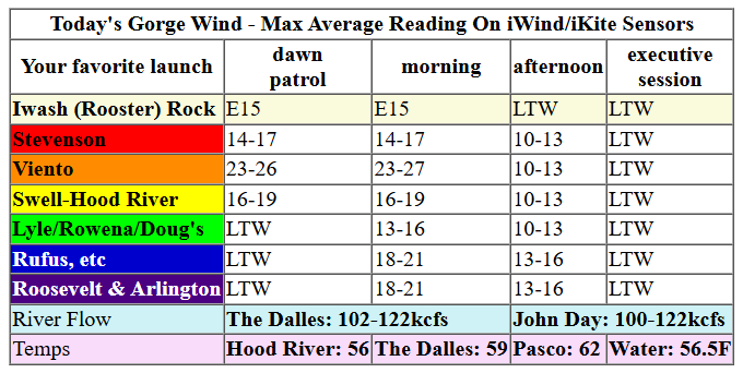
Keep in mind that this forecast attempts to predict what the iKite/iWind sensors will read. Think like a local! All sensors are not equal. Swell reads low. Viento/Arlington/The Wall read high compared to Swell. 30mph at Rufus (The Wall sensor) is about 23-24mph at Swell. 30mph at Swell is about 35-37mph at Rufus/Viento/Arlington. Hope that helps!
SHORT-TERM gorge wind forecast

Hi friends! If you’re up early (like me) you might catch a quick, gusty, rainy session at the Hatch (not like me – still too broken); when I woke up, it was 24 at Viento and 19 at the Hatch and rainy. That’ll hold for a couple hours this morning and potentially spread to the eastern Gorge.
After 11am or so, areas west of The Dalles drop under 10mph, and areas to the east hold at 14-17mph or maybe even 18-21mph for a short bit. After 1pm, all areas see light wind. River flow over the last 24 hours was 100-122kcfs, river temp is 56.5F, and high temp forecast is 56F with rain in the morning and clouds in the afternoon.

RIVER FLOW FOR SITES BETWEEN AVERY (EAST OF THE DALLES) AND RUFUS: CLICK HERE FOR JOHN DAY DAM FLOW.
RIVER FLOW FOR SITES BETWEEN STEVENSON AND DOUG’S BEACH (WEST OF THE DALLES): CLICK HERE FOR THE DALLES DAM FLOW

LONGER-TERM gorge wind forecast
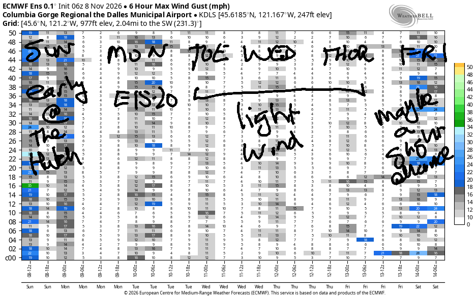
Monday brings easterlies. Morning wind will be 15-20mph at Stevenson, Iwash/Rooster, and Viento. After noon, the wind falls to 10-15mph at Stevenson and 5-10mph at Viento as a weather system moves in. The wind rebuilds to 15-20mph at Iwash mid-afternoon with 10-15mph at Stevenson, but it’ll be pouring rain. High temp: 54 degrees.
Tuesday starts with calm wind. Late in the afternoon, it builds to E 10-15mph at Stevenson and Iwash and Viento, but that’s all you’ll get. Wednesday and Thursday currently have a forecast of light and variable wind. Looking deeper into the future, there’s no clear sign of strong westerlies, and there’s no clear sign of cold desert air that would bring us strong easterlies. So, continue with that off-season training plan!
Tip via venmo, cash or check
Want to subscribe to the email version, support Temira, and get the forecast earlier? Click on the blue box up above or use the methods below. Year-round is $29.99 or more if you think it’s worth more. Only need snow or only need wind? Warm season (May-Oct) or cold season (Nov-Apr) is $19.99 or more if you think it’s worth more. Thanks for your support!

MT HOOD SNOW FORECAST
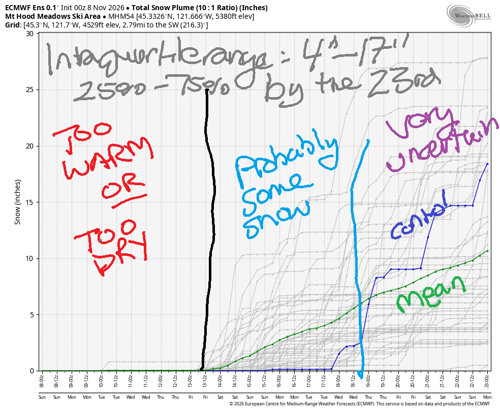
Hey skiers and snowboarders! There were some great deals at the ski swaps in Hood River yesterday, but that’s about all we’ve got for snow news for a bit. Not so much snow in the Mt Hood snow forecast, alas! It’s Sunday morning, and it’s currently snowing at 6500′, perhaps at 6000′, but not at 5000′. A little snow will fall on Sunday, and then the weather turns too warm (or too dry) for snow for the rest of the week. Starting around the 15th, there’s some hint of cool-enough weather (850mb temps around 0C) for a period of snow.
Looking at the Euro ensemble through the 23rd…. basically no snow at 5000′ through the 13th. In the period of the 13th through the 18th, there’s at least some chance of snow at 5000′. Ensembles have temps at 850mb (approximately 5000′) running at -1C to +3C meaning there will likely be periods of snow and periods of rain. Mean snowfall in that period is only about 5” total. Not much.
As we look deeper into the future, uncertainty rises. The intraquartile range for total snow between now and the 22nd is 4-17” accumulation. That’s unlikely to be enough to get the ski areas fully open. So you just keep on waxing your boards and crossing your fingers and doing your calisthenics! We’ll get on the snow eventually!
BARE BONES HOOD RIVER WEATHER FORECAST
Drizzly this morning, mostly cloudy this afternoon. Temps start in the mid 50s and don’t budge. Moderate westerlies this morning. Very light wind this afternoon. 99% chance of rainbows. Monday will be cloudy then rainy after noon. Temps start in the low 40s and rise tot he mid 50s. Light easterlies. 17% chance of rainbows. Tuesday will be cloudy with a little light drizzle possible in the morning. Temps start in the mid 40s and rise to the upper 50s. Calm wind early. Light easterlies later. 4% chance of rainbows.
BIKE TRAILS INFO
NEXT WORK PARTY: November 8th in Post Canyon with the HRATS. meet at Family Man at 9am.
CLOSED TRAILS: Anything south of the 44 Road due to the Grasshopper Fire / Forest Closure Order: for example – Boulder Lakes, Gunsight, Gumjuwac, Lookout Mountain, 450, Fifteenmile.
TEMIRA’S AWESOME TRAVEL ADVISORY SERVICE
HYPERLOCAL WEATHER FORECAST FOR THE COLUMBIA GORGE
THE DALLES, HOOD RIVER, WHITE SALMON, TROUT LAKE, STEVENSON, CASCADE LOCKS, PARKDALE, ODELL, HUSUM, BZ, MILL A, WILLARD, GOLDENDALE, RUFUS, ARLINGTON, boardman
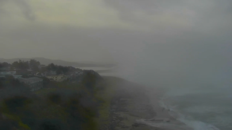
Good morning, neighbors! It’s Sunday morning, and it’s rainy in the west, cloudy to the east, and snowy way up high. Out at the coast, there’s a massive swell: W 19′, and that’s contributing to big ol’ sneaker waves. If you want a peaceful view this morning, take a look at some of the coastal cams and watch the whitewater going wayyyyy up the beach and wayyyyy back out. Closer to home, the biggest weather concern is heavy rain west of Mosier on Monday, enough to make for a rough afternoon and evening commute. For the middles of the week, we’ll be mostly dry, and then there’s a chance of heavy rain late in the week or for the first half of next weekend.
It’s quite warm to start this Sunday morning – 47 degrees in Glenwood and 56 degrees in Hood River, which is pushing into record high-low territory, but didn’t quite set a record. Temps won’t budge much today – the forecast is for highs from 56 degrees to 62 degrees, warmest way out in the desert where it’s not raining this morning. West wind will be 15-20mph this morning and will fade to nearly nothing this afternoon.
Cloud cover Sunday night protects us from a Monday morning frost – lows will be around 40. Afternoon highs will be 54-56. Outdoor activities will be best in the morning, because rain is forecast all the way to the Tri-Cities (City 1, City 2, and City 3) in the afternoon. Afternoon forecast: WET. We’ll see heavy rain west of Hood River from 1pm to 10pm. This will affect your driving. It’ll also be pretty darn rainy as far east as Mosier in that period. East of The Dalles, the rain will be light, but still rainy, and it’ll continue until midnight or so. Wind: E 15-20in the usual east wind spots – Iwash (wiener) Rock, Stevenson, Viento – most of the day.
A little drizzle is possible west of Wyeth on Tuesday morning, but the rest of us should be dry and in the mid 40s. Afternoon: 60 degrees and cloudy. Actually, I’m looking at another model, and there’s uncertainty on Tuesday about the aim of an atmospheric river. It might stay north of us, and it might also make it wet here. Either way, it’ll be warm thanks to SW flow connected with that Pineapple Express. SW flow continues into Wednesday and Thursday and keeps temps rather warm.
Starting next Friday, the flow (likely) turns more westerly and somewhat cooler, While it won’t snow down here, it might snow up in the mountains, and there’s a slight chance it’ll snow on Bennett Pass. Starting next Sunday, it’s possible or maybe even likely all hell will break loose, as I wont’ be here to enjoy it. Safe travels. -TATAS
JONES BEACH, SAUVIE ISLAND, & COAST FORECAST
ON WINTER VACATION UNLESS DESPERATELY NEEDED.

Leave a Reply