

GORGE WIND FORECAST
If you’re still seeing yesterday’s and it’s after 9am, try opening this in an incognito window AND/OR FLUSHING YOUR CACHE or do a do a hard refresh (Ctrl+Shift+R / Cmd+Shift+R)
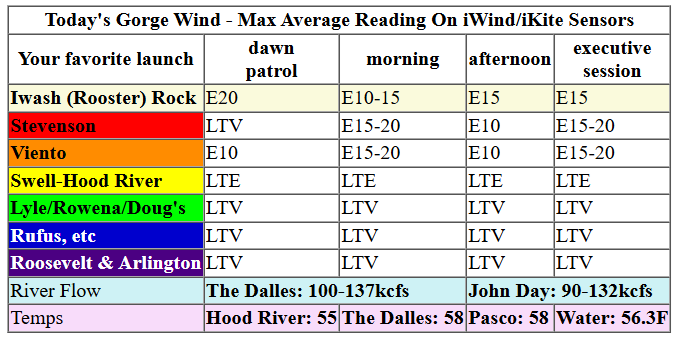
Keep in mind that this forecast attempts to predict what the iKite/iWind sensors will read. Think like a local! All sensors are not equal. Swell reads low. Viento/Arlington/The Wall read high compared to Swell. 30mph at Rufus (The Wall sensor) is about 23-24mph at Swell. 30mph at Swell is about 35-37mph at Rufus/Viento/Arlington. Hope that helps!
SHORT-TERM gorge wind forecast

Hi friends! November continues to do November – damp and not-windy. You should continue to do you, boo! We’ll have moderate easterlies a couple days this week and several days of light/variable wind. There’s a slight chance of frontally-driven westerlies Friday and/or Saturday, but models are not optimistic.
Monday brings easterlies at 10-20mph, depending on the time of day (see chart) at the usual east wind spots. After 11am, rain will accompany the wind, and after 1pm, the rain will be heavy in the east wind zones. Perhaps it’s a better day for the Downpour Jog than wind sports! River flow over the last 24 hours was 90-137kcfs, river temp is 56.3F, and high temp forecast is 55F.

RIVER FLOW FOR SITES BETWEEN AVERY (EAST OF THE DALLES) AND RUFUS: CLICK HERE FOR JOHN DAY DAM FLOW.
RIVER FLOW FOR SITES BETWEEN STEVENSON AND DOUG’S BEACH (WEST OF THE DALLES): CLICK HERE FOR THE DALLES DAM FLOW

LONGER-TERM gorge wind forecast
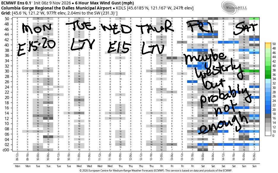
Tuesday looks light and variable. Wednesday brings easterlies at 15mph or less. Thursday looks light and variable. While there’s some chance of west wind on Friday and Saturday, there’s also a better chance of heavy rain. Once again, the Downpour Jog will be a better option. Take care, everyone! See you on the Nch’i Wana one of these days!
Tip via venmo, cash or check
Want to subscribe to the email version, support Temira, and get the forecast earlier? Click on the blue box up above or use the methods below. Year-round is $29.99 or more if you think it’s worth more. Only need snow or only need wind? Warm season (May-Oct) or cold season (Nov-Apr) is $19.99 or more if you think it’s worth more. Same for the cold season forecast. Thanks for your support!

MT HOOD SNOW FORECAST
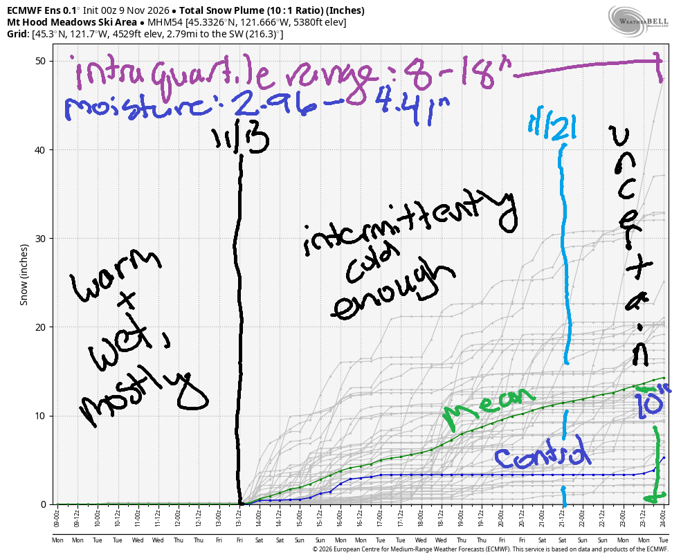
Hi skiers and snowboarders! Quite a bit of rain arrives in the Mt Hood snow forecast (hey, where’s our snow?!?!) between now and the end of next weekend, but temps will be too warm for snow at the resorts through at least Sunday morning.
Starting on Sunday (the 15th), models suggest up to a week where temps at 5000′ will intermittently be cold enough for (wet, base-building) snow. The most likely scenario is around 10” of snow at 5000′ in that time period with some outliers predicting up to 30”. Intraquartile range (25th-75th percentile) is 8-18” of snow. After the 21st, uncertainty climbs, and it’s not really possible to make predictions. So, it doesn’t look like we’ll have ski season by Thanksgiving unless something changes. Fingers crossed!
BARE BONES HOOD RIVER WEATHER FORECAST
Cloudy this morning with moderate to heavy rain this afternoon and evening. Temps start in the low 40s and rise to the mid 50s. Light easterlies. 3% chance of rainbows. Tuesday will be drizzly early then partly cloudy. Temps start in the mid 40s and rise to the upper 50s. Light and variable wind. 81% chance of rainbows. Wednesday will be partly Nothing then high overcast. Temps start in the mid 40s and rise to the low 60s. Light easterlies. No rainbows.
BIKE TRAILS INFO
NEXT WORK PARTY: Unknown.
CLOSED TRAILS: Anything south of the 44 Road due to the Grasshopper Fire / Forest Closure Order: for example – Boulder Lakes, Gunsight, Gumjuwac, Lookout Mountain, 450, Fifteenmile.
TEMIRA’S AWESOME TRAVEL ADVISORY SERVICE
HYPERLOCAL WEATHER FORECAST FOR THE COLUMBIA GORGE
THE DALLES, HOOD RIVER, WHITE SALMON, TROUT LAKE, STEVENSON, CASCADE LOCKS, PARKDALE, ODELL, HUSUM, BZ, MILL A, WILLARD, GOLDENDALE, RUFUS, ARLINGTON, boardman
Good morning, neighbors! Moist, unseasonably warm weather is on tap this week. Or maybe it’ll be unseasonably warm and wet. Either way… no chance of snow or ice for the lowlands, and hopefully no !CE either! An unpleasant commute is on tap Monday evening, and another round of heavy rain is possible Friday into Saturday. Starting next week, the weather turns cooler, but still not especially wintry…
It’s Monday morning, and the weather’s not wintry in Glenwood: it’s 36 degrees there this morning. Cool enough that it could frost if it weren’t cloudy, and warm enough to keep the puddles from freezing. In The Dalles, it’s also not wintry – it’s 46 degrees. Temps slowly climb to the 55-58F range today as a weather system approaches. By 10am or 11am, it’ll be drizzling as far east as Hood River. By this afternoon, we’ll have rain all the way to Arlington’s Triangle, whatever that is. Between 1pm and 9pm, heavy rain falls west of Hood River, and after 4pm, moderate to heavy rain extends all the way to Arlington. Be prepared for an “exciting” drive this afternoon and slowwwwww down to protect yourself and others. Wind today: easterlies at 10-20mph in the usual spots.
Rain tapers off after 10pm Monday and leaves us with a short dry window (different than a “short drive-up window”, which is where short people go in their short cars for food made by short-order cooks) after midnight. Drizzle returns early Tuesday morning as far east as Biggs and lingers as far east as Stevenson through noon or so. By afternoon, we’ll have sunbreaks. Highs: nearly 60 degrees after a mid-40s start. Wind: not an issue – it’ll be light and variable all day.
A Nothing cloud starts Wednesday gloomy, no, scratch that, COZY near the Nch’i Wana. Away from it: partly high overcast sky. Morning temps: 40-45 degrees. Afternoon: low 60s with increasing high clouds. Wind: easterly at 10-15mph in the usual east wind spots (think: Iwash (not-a-rooster) Rock and Stevenson). Thursday looks dry, 60 degrees, and not windy.
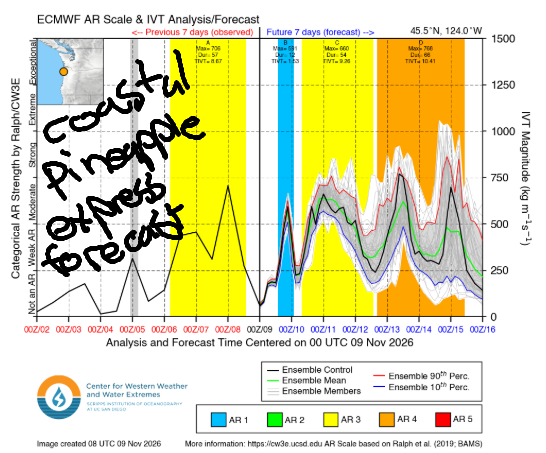
In the Friday-Saturday window (do not jump out of the window, and do not throw others out the window), models offer up another atmospheric river with the potential for heavy rain and continued warm weather. Details remain unclear, but it’s likely you’ll need fresh windshield wipers for clear windscreens. At least you’ll be able to wash the flies off your windscreens!
As we gaze deeply into the eyes of next week, we see somewhat cooler weather. Nothing too exciting – we’re not expecting weather cold enough for snow or ice, which means you’ll have to substitute Pumpkin Spice to spice things up. Or eggnog. That should be available in the grocery stores now too. Safe travels. -TATAS
JONES BEACH, SAUVIE ISLAND, & COAST FORECAST
ON WINTER VACATION UNLESS DESPERATELY NEEDED.

Leave a Reply