

GORGE WIND FORECAST
If you’re still seeing yesterday’s and it’s after 9am, try opening this in an incognito window AND/OR FLUSHING YOUR CACHE or do a do a hard refresh (Ctrl+Shift+R / Cmd+Shift+R)
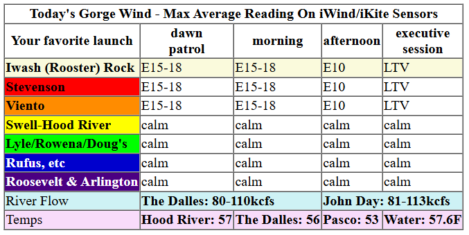
Keep in mind that this forecast attempts to predict what the iKite/iWind sensors will read. Think like a local! All sensors are not equal. Swell reads low. Viento/Arlington/The Wall read high compared to Swell. 30mph at Rufus (The Wall sensor) is about 23-24mph at Swell. 30mph at Swell is about 35-37mph at Rufus/Viento/Arlington. Hope that helps!
SHORT-TERM gorge wind forecast

Hi friends! Not much going on in the Gorge wind forecast for the next five days or so. A nice way to use this time would be to start your ski season training! Best chance for westerlies is Thursday and/or Sunday, but signs of even 17-20mph are poor.
Wednesday starts with moderate EASTerlies: 17-20mph at Viento, Iwash, and Stevenson. If you go to the easterlies, you may find yourself free of the Nothing cloud! Easterlies hold until late morning then drop off the cliff. By the end of the day, conditions will be light/variable. River flow over the last 24 hours was 80-113kcfs, river temp is 57.6F, and high temp forecast is 57F.

RIVER FLOW FOR SITES BETWEEN AVERY (EAST OF THE DALLES) AND RUFUS: CLICK HERE FOR JOHN DAY DAM FLOW.
RIVER FLOW FOR SITES BETWEEN STEVENSON AND DOUG’S BEACH (WEST OF THE DALLES): CLICK HERE FOR THE DALLES DAM FLOW

LONGER-TERM gorge wind forecast
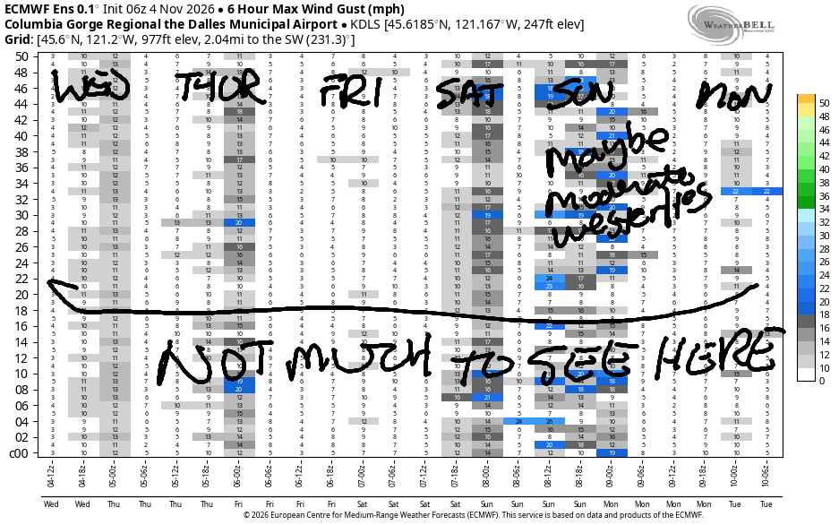
We’ll be post-frontal on Thursday as a weak weather system swings through. Early wind will be 10-13mph from Stevenson to Arlington. We’ll likely see a period of 17-20mph from Avery to Boardman for a few hours in the morning. Afternoon wind fades under 10mph all through the Gorge. High temp: 59F and cloudy.
Friday brings light easterlies: 15-18mph max for a few hours in the morning. Afternoon: light/variable. Another round of moderate easterlies is likely on Saturday. There’s a chance of westerlies on Sunday following a Saturday night weather system, but there’s zero sign they’ll be stronger than 20mph. Let’s leave it there for now! Have a great day everyone!
Tip via venmo, cash or check
Want to subscribe to the email version, support Temira, and get the forecast earlier? Click on the blue box up above or use the methods below. Year-round is $29.99 or more if you think it’s worth more. Only need snow or only need wind? Warm season (May-Oct) or cold season (Nov-Apr) is $19.99 or more if you think it’s worth more. Same for the cold season forecast. Thanks for your support!

MT HOOD SNOW FORECAST
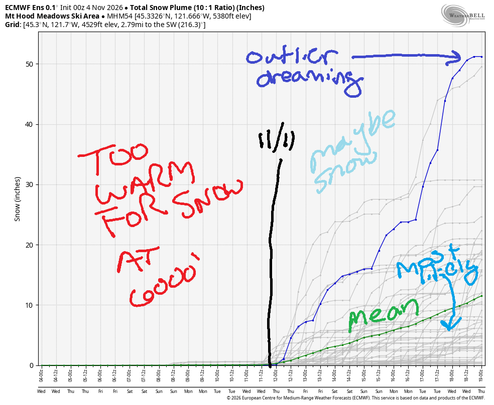
Hey skiers and snowboarders! The mountains are still looking lovely from the last snowfall, but there’s not enough snow to get ski season going yet. In the next week or so, there will be a few short periods where the snow level falls to 5000′ or less, but no significant snow is anticipated in the Mt Hood snow forecast. A couple inches are possible after midnight Wednesday (11/4) into Thursday, and another couple inches are anticipated Saturday night (11/7) into Sunday.
Beyond Sunday, the weather is likely to turn warm again, and there’s about a 30% chance of a significant Pineapple Express. Looking way out into the future, beyond 11/14, temps slide, but probably don’t slide enough for significant snowfall at 5000′ through the 18th. Now would be a good time to get your skis tuned!
Coming up on the 7th, there’s the annual Gorge Winter Gear Swap at Hood River Valley High School on Saturday, November 7th. 8Am early admission ($25), and 9am regular admission ($5/person, $10/family). On the same day, but from 4-6pm, there’s the Nordic Gear Swap at Working Hands Brewery in Hood River. It’s time to get new-used gear or sell your old stuff!
BARE BONES HOOD RIVER WEATHER FORECAST
Nothing and fog this morning. Mostly cloudy this afternoon. (It’s sunny above the Nothing!) Drizzle this evening. Temps start near 40 and rise to the upper 50s. Light easterlies. No rainbows. Thursday will be showery n the morning and cloudy and high overcast in the afternoon. Temps start in the low 40s and rise to the upper 50s. Light westerlies. 99% chance of rainbows. Friday will be cloudy but dry. Temps start in the upper 30s and rise to the upper 50s. Light easterlies. No rainbows.
BIKE TRAILS INFO
NEXT WORK PARTY: November 8th in Post Canyon with the HRATS.
CLOSED TRAILS: Anything south of the 44 Road due to the Grasshopper Fire / Forest Closure Order: for example – Boulder Lakes, Gunsight, Gumjuwac, Lookout Mountain, 450, Fifteenmile.
TEMIRA’S AWESOME TRAVEL ADVISORY SERVICE
HYPERLOCAL WEATHER FORECAST FOR THE COLUMBIA GORGE
THE DALLES, HOOD RIVER, WHITE SALMON, TROUT LAKE, STEVENSON, CASCADE LOCKS, PARKDALE, ODELL, HUSUM, BZ, MILL A, WILLARD, GOLDENDALE, RUFUS, ARLINGTON, boardman
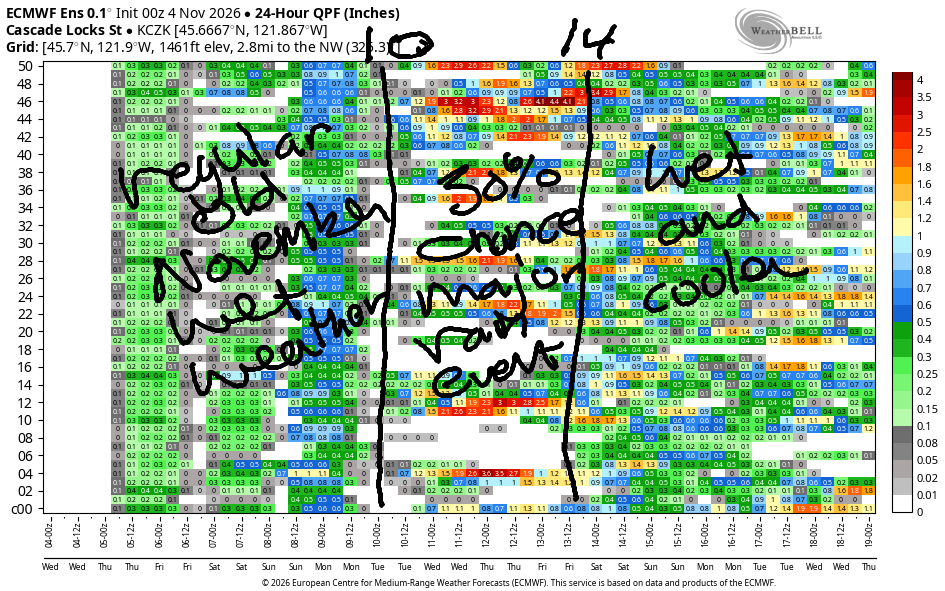
Good morning, neighbors! TATAS cried tears of relief this morning in the hope that the wave of greed and hatred engulfing this country may be retreating. I’m under no illusion that any political party can transform the USA into a haven of kindness – that’s up to us – but hopefully our new leaders will be more inclusive, more inspirational role models. We all deserve the right to live free of fear. We all deserve healthcare. We all deserve food and housing security. Know what else we all deserve? Rain! While there won’t be a ton of rain in the next few days, there is plenty of rain (see image) all the way through the middle of November.
Wednesday looks like rain from my house, but it’s really Nothing. If you go up higher than Nothing, you’ll break through the fog and find the sun. It’s glorious up there! Early temps: 40F in Glenwood, where I’m guessing it’s Nothing. 27-32F in Parkdale, where I’m guessing it’s clear. Webcams at Meadows: sunny as can be! Nothing dissipates today, but it’s replaced by mid and high clouds ahead of an incoming (blue) cold front. That system drops a little rain as far east as Stevenson (4pm), Celilo Village (7pm), and the Tri-Cities (10pm). Today’s wind will be E 15-20mph west of Hood River in the usual windy spots for the morning hours. Afternoon: light and variable everywhere. Highs range from 53 to 57.
Overnight drizzle continues until sunrise as far east as The Dalles and through 10am west of Wyeth (exit 51, where ICE sometimes stages before descending on Gorge communities). Low clouds start the day west of The Dalles. To the east: high clouds to start. Early temps: upper 30s to mid 40s. West wind peaks in the morning at 10-15mph west of The Dalles and 15-20mph to the east. Combine the wind and the drizzle for rainbows. Afternoon: high clouds and light wind with temps right around 60 (record is mid to upper 60s).
Cloudy, dry, light-wind weather is forecast on Friday. Morning temps: upper 30s. Afternoon: 56-59. Saturday: excellent weather – partly cloudy, low 60s, and light east wind. Overnight, a bit of rain moves in, but it’ll be gone by daybreak Sunday, when we’ll have a partly to mostly cloudy day with 60 degree temps and light west wind. Damn…. that sure sounds nice. I see lots of garden dismantling in my future!
Beyond that, there’s plenty of uncertainty (kinda like national conditions between now and inauguration day). In an exciting twist, about 30% of the Euro ensemble members want to gift us a Pineapple Express in the 10-14 November time period. Rain, glorious rain! My fingers are crossed for this! Rain is good, but you know what’s better? The opportunity to eat all the pineapple-associated foods: upside-down cake, tacos al pastor, and of course, pizza! Safe travels. -TATAS
JONES BEACH, SAUVIE ISLAND, & COAST FORECAST
ON WINTER VACATION UNLESS DESPERATELY NEEDED.

Leave a Reply