

GORGE WIND FORECAST
If you’re still seeing yesterday’s and it’s after 9am, try opening this in an incognito window AND/OR FLUSHING YOUR CACHE or do a do a hard refresh (Ctrl+Shift+R / Cmd+Shift+R)
SHORT-TERM gorge wind forecast

Hi friends! Not much happens in wind world on Tuesday, but westerlies return on Wednesday. Strong west wind is forecast on Thursday (with caveats), lesser wind Friday, and strong wind Saturday with continued westerly flow into the deep future.
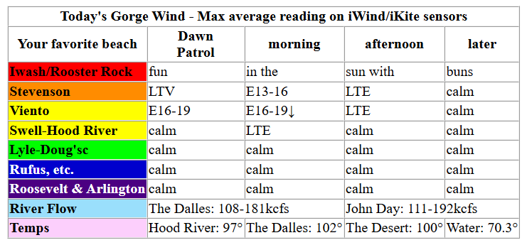
6am gradients on Tuesday were 29.92/29.96/29.96 for E 0.04 between Portland and The Dalles. We won’t see much wind today, and what we do see will come from the east. At dawn, Viento (which reads high) was at 19mph. Stevenson was light/variable. We’ll see peak easterlies mid-morning at 13-16mph at Stevenson and Home Valley with 16-19mph at Viento. Wind fades by early afternoon and quickly turns calm. River flow over the last 24 hours was 108-192kcfs, river temp is 70.3F, and high temp forecast is 97F.
Westerlies return on Wednesday, but a complicated overall weather picture complicates the forecast. Early wind will be dead calm. In the afternoon, several factors combine to give us a chance at gusty 19-22mph (Stevenson to Rufus), but other factors impact the likelihood of this. First, a weather impulse ahead of a low moving up the coast combines with the heat and humidity to destabilize the atmosphere and potentially kick off elevated thunderstorms. These type of storms often allow surface wind to continue, but it’s never a good idea to be on the river when lightning is around! Smoke will also impact temps, which would impact the thermal gradient that aids wind development. High temp: 100F and super-duper muggy. High temps could be suppressed by smoke coverage.
RIVER FLOW FOR SITES BETWEEN AVERY (EAST OF THE DALLES) AND RUFUS: CLICK HERE FOR JOHN DAY DAM FLOW.
RIVER FLOW FOR SITES BETWEEN STEVENSON AND DOUG’S BEACH (WEST OF THE DALLES): CLICK HERE FOR THE DALLES DAM FLOW

LONGER-TERM gorge wind forecast
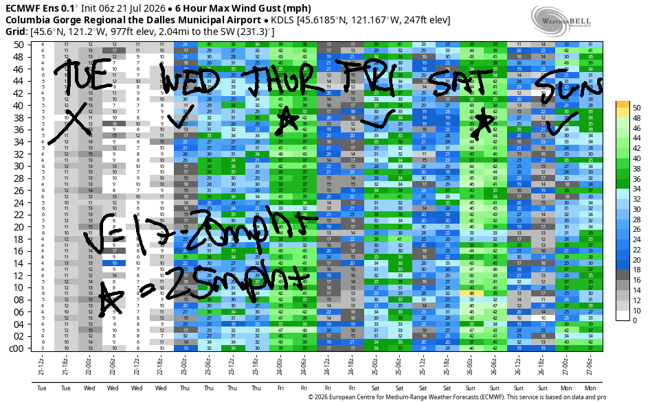
Instability continues on Thursday morning. If it’s not too thunderstormy, we should see dawn patrol at 23-26mph from Viento to Mosier with 20-23mph from Lyle to Arlington. Conditions should stabilize in the afternoon. If it all pans out right, we’ll have 26-29mph from Stevenson to Hood River with 30-33mph from Mosier to Arlington. It’s not an ideal setup – a low pressure system will be present offshore. Even so, thermal gradients across the Cascades will give the Gorge the nudge it needs. Wind will be strongest after noon thanks to the assistance of desert heating. High temps: 89 in Hood River and 103 in Pasco.
Westerlies continue on Friday, but models aren’t quite sure how strong they’ll be. 20mph or more seems nearly guaranteed, and with instability gone from the picture, the wind will be less gusty and more reliable. Stronger westerlies are forecast on Saturday as offshore high pressure returns, marine clouds blanket the west side, and desert heat persists. Sunday won’t be quite as strong, but westerlies should continue at 17-20mph or more. Looking deeper into the future, there’s quite a bit of range in how strong the west wind will be, but it does look like 17-20mph or more all next week. Fingers crossed! See you on the Nch’i Wana soon!

Was that helpful? I knew it was! Guess what? All of this crucial work – from your personal wind and snow reports to the invaluable TATAS updates – is made possible by my relentless efforts. Maintaining this labor of love isn’t easy. Each daily forecast takes hours. Website hosting, weather model access, and back-end admin work takes time and money. That’s where you come in.
YOUR CONTRIBUTION MAKES A DIFFERENCE
- SUPPORT ACCURATE, HYPER-LOCAL WEATHER FORECASTING
- ENABLE ACCESS FOR ALL, EVEN THOSE WITH LESS MEANS
- SUPPORT A COOL HUMAN WHO WORKS HARD SO YOU CAN PLAY
Take a moment to click one of the buttons below. Donate $19.99 or more (how much does this forecast enhance your life?) and get the email in your inbox. Whether it’s a renewing subscription (auto-renew) or a one-time donation, every contribution makes a real difference. Help me keep this labor of love alive, so we can all continue playing, commuting, and living in the Gorge with peace of mind and the best weather forecasts possible. Thank you!


Hood River, Oregon 97031


JONES BEACH, SAUVIE ISLAND, & COAST FORECAST
Wind northerly unless otherwise indicated. For coast, it’s North/Central/South with the “central” at approximately Florence. Swell forecast from NWS for central coast. Jones: westerly unless otherwise stated. Sauvie Island: northerly unless otherwise stated.
Coast Tuesday: NW10-15/NNW10/N15, NW swell 4′ at 8 seconds and SW 2′ @ 15. Wednesday: LTV/SW10/S15, NW 4′ @ 8 and SW 2′ @ 15. Thursday: S 15/S10/S15, NW 5′ @ 9. Jones Tuesday: 12-15. Wednesday: 18-21. Thursday: LTW. Sauvie Island Tuesday: 10-13. Wednesday: 12-15. Thursday: NW 10-13.
BARE BONES HOOD RIVER WEATHER FORECAST
Mostly clear with smoke today. Temps start near 60 and rise to the upper 90s unless smoke cools us off. Muggy. Light east wind becoming calm. No rainbows. Wednesday will be smoky then partly cloudy with a chance of thunderstorms. Muggy AF. Temps start in the upper 60s and have the potential to rise to 100. Calm wind early. Moderate westerlies later. No rainbows. Thursday will be partly cloudy with a chance of thunder then mostly clear. Smoke: yes, but lessening. Temps start in the upper 60s and rise to the upper 80s. Muggy in the morning. Less so later. Strong westerlies. No rainbows.
TEMIRA’S AWESOME TRAVEL ADVISORY SERVICE
HYPERLOCAL WEATHER FORECAST FOR THE COLUMBIA GORGE
THE DALLES, HOOD RIVER, WHITE SALMON, TROUT LAKE, STEVENSON, CASCADE LOCKS, PARKDALE, ODELL, HUSUM, BZ, MILL A, WILLARD, GOLDENDALE, RUFUS, ARLINGTON, boardman
Good morning, neighbors! Lots going on in the forecast: smoke, instability, humidity, heat, and the potential for elevated, dry thunderstorms Wednesday and Thursday. The last thing we need is more lightning, but it looks like we may see some. Also in the cards: very warm morning temps the next couple days. It’s going to be hard to cool off for folks without AC. Do check in on vulnerable folks in your circle and outside of it.
Tuesday kicked off so smoky that it’s hard to tell if it’s cloudy! Satellite image says there are few clouds. Just lots of smoke. Glenwood was 49 degrees to start the day. Must be nice! The rest of us ranged from the mid 50s to upper 60s. Today’s high temp forecast ranges from 97 in Stevenson and Hood River to 102 in The Dalles and 100 in Pasco. Actual highs depend on how much the smoke limits heating. Humidity today will be tolerable as dewpoints hover in the 50-55F range west of Stevenson and 44-48F to the east. Wind today will max out at 10-15mph out of the east near Stevenson for a few hours. Other than that, expect light wind. Elsewhere in the world….
Bandar-e Mahshahr, Iran: 115, sunny, 11% humidity
Havana, Cuba: 79, sunny, 83% humidity
Muscat, Oman: 98, partly cloudy, 49% humidity
Caracas, Venezuela: 69, cloudy, 87% humidity
Nuuk, Greenland: 52, cloudy, 87% humidity
Gaza City: 90, sunny, 57% humidity
Ottawa, Canada: 68, cloudy, 79% humidity
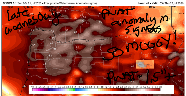
On Wednesday morning, it’ll be noticeably stickier thanks to moisture streaming in from the remnants of an offshore tropical storm. Morning temps will be pushing 70 degrees in many locations. HOT! Hood River’s record high-low for 7/22 is 71 degrees. A record is possible given the ridiculous (4 sigmas!!!) amount of available moisture. Temps aloft remain super-hot (25C), which gives us the potential for 100 degrees in Hood River and 106 degrees in The Dalles for high temps. Once again, there’s potential for smoke to affect high temps as southerly flow aloft sends smoke north from all the fires. Surface wind will be calm in the morning and westerly at 15-20mph in the afternoon. Now for the fun/not-fun stuff: the combo of moisture, southerly flow, a weather feature, and terrain assistance gives us the potential for elevated thunderstorms in the afternoon. These sorts of storms tend to bring dry lightning, which is the last thing we need right now.
Instability continues into Thursday morning when we’ll again have a nearly 70 degree, partly cloudy, potentially thunderstormy start to the day. Mugginess and instability continue through midday and decreases in the afternoon. High temps will be down for many locations, thankfully: Stevenson: 86; Hood River: 89; The Dalles: 96; Pasco: 103. West wind starts at 20-25mph between Stevenson and Arlington and builds to 30+ mph all the way from Stevenson to the Arlington Triangle. Combine that with the uncontained fires plus potential lightning strikes Wednesday into Thursday morning for extreme fire danger and fire spread. Not good.
On Friday, we’ll see clouds to the west in the morning and sun to the east all day. Highs: 85-99, coolest to the west. West wind will be 15-20mph to start and 25mph to finish. Saturday looks cooler and very windy. Generally speaking, the weather looks seasonable (80ish to the west, 90-something to the east) and breezy through the middle of next week when there’s a hint of slightly warmer weather but nothing extreme. Other than any sprinkles we see from any thunderstorms that pop up, there’s no sign of rain in the next couple of weeks. Stay cool today! Safe travels. -TATAS
HEY! DON’T STOP READING! Is this community-focused forecast helpful to you? It sure is! It takes me a couple hours a day to write. Please join your friends and neighbors in contributing to keep it going. Venmo: @thegorgeismygym PayPal: twomirrors@gmail.com USPS: Temira / PO Box 841 / Hood River, Oregon 97031 You can test out the forecast subscription for a few days for free by signing up below. Easy! Do it!
MT HOOD SNOW FORECAST

QR codes and links for end-of-season tips – thank you!!!
Cash/check: Temira – PO BOX 841 – Hood River, Oregon 97031