

GORGE WIND FORECAST
If you’re still seeing yesterday’s and it’s after 9am, try opening this in an incognito window AND/OR FLUSHING YOUR CACHE or do a do a hard refresh (Ctrl+Shift+R / Cmd+Shift+R)
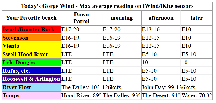
Keep in mind that this forecast attempts to predict what the iKite/iWind sensors will read. Think like a local! All sensors are not equal. Swell reads low. Viento/Arlington/The Wall read high compared to Swell. 30mph at Rufus (The Wall sensor) is about 23-24mph at Swell. 30mph at Swell is about 35-37mph at Rufus/Viento/Arlington. Hope that helps!
SHORT-TERM gorge wind forecast

Hi friends! A couple days of light to moderate easterlies are on tap. West wind likely returns late in the day on Wednesday as the heat low shifts to the east of the Cascades. Moderate westerlies continue on Thursday, and the wind increases as we move into next weekend. Flow looks generally westerly next week, but the details aren’t clear yet. They’ll become even less clear as I’ll be gone Sunday through the following Sunday for a retreat for a program I’m in, and my housesitter doesn’t know how to forecast wind for you!
Tuesday morning started with pressures of 29.98/30.04/30.05 for offshore gradients and east wind. Stevenson and Viento started the day at 14-17mph, and Iwash/Rooster was 10-13mph. The wind builds to 17-20mph for all the launch spots between Iwash/Rooster Rock and Viento for a few hours this morning. By 2pm, the wind drops below 15mph everywhere and rises to 10mph from Hood River eastward to Rufus. River flow over the last 24 hours was 99-136kcfs, river temp is 70.3F, and high temp forecast is 89F and smoky.

RIVER FLOW FOR SITES BETWEEN AVERY (EAST OF THE DALLES) AND RUFUS: CLICK HERE FOR JOHN DAY DAM FLOW.
RIVER FLOW FOR SITES BETWEEN STEVENSON AND DOUG’S BEACH (WEST OF THE DALLES): CLICK HERE FOR THE DALLES DAM FLOW

LONGER-TERM gorge wind forecast
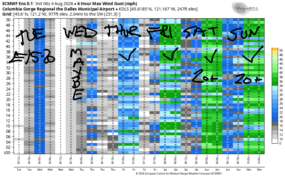
Wednesday starts with east wind at 14-17mph at Viento, Home Valley, and Stevenson with 10-13mph at Iwash/Rooster Rock. The wind quickly fades. By midday, it’ll be light/variable. We then see a slow rise in the westerlies into the evening. Most of the time, the switch happens slower than expected and is weaker than expected. If we get lucky and avoid that pattern, we’ll see 13-16mph from Stevenson to Doug’s on Wednesday evening. High temp: 95F and less smoky.
Onshore temperature gradients (warmer to the east, cooler to the west) combine with weak offshore high pressure for a hot west wind day on Thursday. Early wind will be 15-18mph from Viento to the Hatch. Midday: 19-22mph from Stevenson to Mosier with 13-16mph near Rowena and 10-13mph near Rufus. Afternoon wind falls to 16-19mph from Stevenson to Mosier and rises to 20-23mph from Lyle to Rufus. High temp: 97F in Hood River and 100+ in the desert, definitely warm enough to make the wind feel less punchy than usual.
Friday, Saturday, and Sunday benefit from a relatively stable setup: heat low in the desert, offshore high pressure, some degree of morning marine clouds over the metro area. Most members of the Euro ensemble forecast approximately 22-26mph daily from Friday on through the middle of next week. High temps will be somewhere in the 80-90 range starting Sunday and holding through much of the week. Should be a good stretch of wind! You’ll have to get some for me every day! See you on the Nch’i Wana soon!
Tip via venmo, cash or check
Want to subscribe to the email version, support Temira, and get the forecast earlier? Click on the blue box up above or use the methods below. Year-round is $29.99 or more if you think it’s worth more. Only need snow or only need wind? Warm season (May-Oct) or cold season (Nov-Apr) is $19.99 or more if you think it’s worth more. Same for the cold season forecast. Thanks for your support!

JONES BEACH, SAUVIE ISLAND, & COAST FORECAST
Wind northerly unless otherwise indicated. For coast, it’s North/Central/South with the “central” at approximately Florence. Swell forecast from NWS for central coast. Jones: westerly unless otherwise stated. Sauvie Island: northerly unless otherwise stated.
Coast Tuesday: 20-25/20-25/25-30, NW swell 7′ at 7 seconds. Wednesday: 15-20/15-20/LTN, N 7′ @ 7. Thursday: 10-15/15-20/15-20??, NW 5′ @ 8. Jones Tuesday: LTW. Wednesday: 19-22. Thursday: 19-22. Sauvie Island Tuesday: 16-19. Wednesday: 14-17. Thursday: 11-14.
BARE BONES HOOD RIVER WEATHER FORECAST
Very smoky this morning. Less smoky this afternoon. Temps start in the upper 40s and rise to the upper 80s. Light easterlies. No rainbows. Wednesday will be smoky. Temps start near 60 and rise to the mid 90s. Light easterlies early. Moderate westerlies later in the day. No rainbows. Thursday will be sunny with decreasing smoke. Temps start in the low 60s and rise to the upper 90s. Moderate westerlies. No rainbows.
TEMIRA’S AWESOME TRAVEL ADVISORY SERVICE
HYPERLOCAL WEATHER FORECAST FOR THE COLUMBIA GORGE
THE DALLES, HOOD RIVER, WHITE SALMON, TROUT LAKE, STEVENSON, CASCADE LOCKS, PARKDALE, ODELL, HUSUM, BZ, MILL A, WILLARD, GOLDENDALE, RUFUS, ARLINGTON, boardman
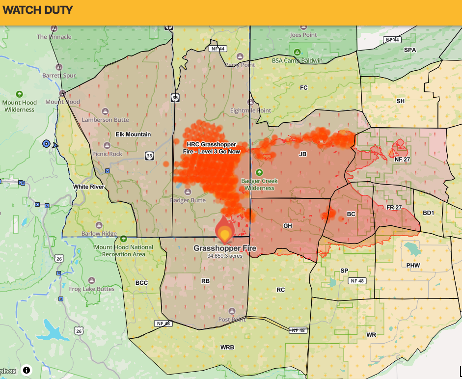
Good morning, neighbors! It’s apocalyptic out there this morning with AQI readings around 175 all through the Gorge. Better than the Govy and Welches area – some folks in that stretch have AQI over 500, and it’s also better than Pine Hollow, which was reading 1127 as I was typing this. With east wind forecast through the middle of Wednesday, many evac levels have changed. Mt. Hood Meadows is now at Level 3, and the Grasshopper fire is chewing up Boulder Lakes, Gunsight Ridge, and Lookout Mountain.
Our friends around the world this morning
I don’t have AQI readings for our friends around the world, but here’s the weather they were experiencing at 7am PST today:
Bandar-e Mahshahr, Iran: 106, sunny, 35% humidity
Havana, Cuba: 82, partly cloudy 76% humidity
Muscat, Oman: 92, sunny, 71% humidity
Caracas, Venezuela: 76, sunny, 76% humidity
Nuuk, Greenland: 48, partly cloudy, 91% humidity
Gaza City: 87, sunny, 66% humidity
Ottawa, Canada: 70, sunny, 72% humidity
Today’s Gorge weather forecast
Here in the Gorge, we’ll see both the near-surface smoke and elevated smoke diminish this afternoon as east wind forces in somewhat less smoky air. Were you wondering where the smoke was coming from? It’s coming from the north – mostly from the Little Giant and Kaiser Canyon fires. (Eek – I almost forgot to tell you about Glenwood – it was 37 degrees there this morning). After a nice cool start this morning – OPEN ALL THE WINDOWS AND DOORS, NO WAIT, IT’S SMOKY, DON’T, NO WAIT, IT’S COOL, OH SHIT I DON’T KNOW WHAT TO DO, BUTY MY WINDOWS ARE OPEN – we’ll have a pretty darn hot afternoon even with the smoke blocking some of the sun. Stevenson: 90. Hood River: 89. The Dalles: 93. Pasco: 91. East wind rises to 20mph between Iwash (dick) Rock and Viento with 10mph east of Viento out into the desert.
Wednesday’s Gorge weather forecast
Overnight, temps fall to 50-65 degrees. Smoke does not stop radiational cooling, thankfully. Smoke models disagree on how Wednesday will start – one has the AQI at 250+ due to the Grasshopper Fire, and the other has us at 50-150. I’ll go with the latter except in the Upper Valley, where it may be very smoky. Mid-afternoon brings a switch to west wind which will SLOWLY start to clear the air. Afternoon temps rise to the mid 90s west and east of The Dalles and nearly 100 in the vicinity of The Dalles. Wind will be E 10-15mph in the morning (mostly west of Hood River – calm to the east) and west 15mph in the evening between Stevenson and The Dalles.
Thursday’s Gorge weather forecast
HOT weather is forecast Thursday. We start 55-70 degrees and end 97-102, hottest near The Dalles. Smoke will be slowly diminishing. West wind starts at 15mph between Viento and Hood River and builds to 20mph between Stevenson and Rufus.
Extended Gorge weather forecast
A slow cooling trend is forecast into the weekend, when highs should mostly drop below 90 degrees. West wind at 20-25mph is forecast daily along with similar temps through the middle of next week. You enjoy that. I’ll be in California on a retreat, and my housesitter will be enjoying the Gorge. Safe travels to me. Honestly, I’m a bit scared of being in a remote forest location for a week with conditions this dry… Safe travels to you. -TATAS
HEY! DON’T STOP READING! Is this community-focused forecast helpful to you? It sure is! It takes me a couple hours a day to write. Please join your friends and neighbors in contributing to keep it going. Venmo: @thegorgeismygym PayPal: twomirrors@gmail.com USPS: Temira / PO Box 841 / Hood River, Oregon 97031 You can test out the forecast subscription for a few days for free by signing up below. Easy! Do it!
MT HOOD SNOW FORECAST

QR codes and links for end-of-season tips – thank you!!!
Cash/check: Temira – PO BOX 841 – Hood River, Oregon 97031



One response to “Tuesday Gorge wind forecast & Gorge weather: it’s smoke season. east wind for a couple days, then westerlies and cleaner air…”
Temira, I have long enjoyed your forecasts and gorge color and have donated and subscribed for many years. My question/issue is that managing or even checking on what my subscription payment level is is difficult from your end. (Setting it up and just letting it run, oh yeah, how do I pay and how much??). Okay I figured it out as a paypal payment through one of my less used sources which I am going to reset so it is clearer going forward. But as far as I can tell on your end I cannot see the level that I subscribed at, all I can find is an “unsubscribe” option. Does that just stop your emailed forecasts or does it also end whatever automated payments that I have set up for your forecasts?