

GORGE WIND FORECAST
If you’re still seeing yesterday’s and it’s after 9am, try opening this in an incognito window AND/OR FLUSHING YOUR CACHE or do a do a hard refresh (Ctrl+Shift+R / Cmd+Shift+R)
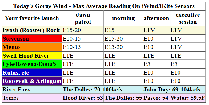
Keep in mind that this forecast attempts to predict what the iKite/iWind sensors will read. Think like a local! All sensors are not equal. Swell reads low. Viento/Arlington/The Wall read high compared to Swell. 30mph at Rufus (The Wall sensor) is about 23-24mph at Swell. 30mph at Swell is about 35-37mph at Rufus/Viento/Arlington. Hope that helps!
SHORT-TERM gorge wind forecast

Hi friends! Very little to talk about in the Gorge wind forecast for the next several days, and not much sign of wind beyond that either. The Euro ensemble image looks as not-windy as its ever looked, and that look continues into the next couple of weeks. Your best shot for wind in the next few days comes in the form of easterlies that may touch 20mph thanks to offshore low pressure.
Thursday’s easterlies max out around 15mph at Stevenson and perhaps Viento this morning. Iwash/Rooster should be around 10mph this morning. Afternoon wind drops below 10mph at all locations. River flow over the last 24 hours was 69-104kcfs, river temp is 59.5F, and high temp forecast is 53 degrees in Hood River.

RIVER FLOW FOR SITES BETWEEN AVERY (EAST OF THE DALLES) AND RUFUS: CLICK HERE FOR JOHN DAY DAM FLOW.
RIVER FLOW FOR SITES BETWEEN STEVENSON AND DOUG’S BEACH (WEST OF THE DALLES): CLICK HERE FOR THE DALLES DAM FLOW

LONGER-TERM gorge wind forecast
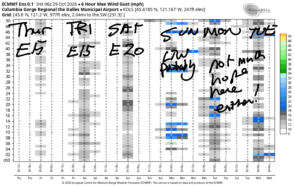
Friday sees morning easterlies at 15-18mph near Stevenson and Viento. Iwash/Rooster will be light and variable. Afternoon wind turns light westerly all through the Gorge with peak wind around 10mph in Stevenson after 2pm. High temp: 53.
Saturday brings another round of easterlies. Early wind will be 15-20mph at Iwash/Rooster and 15mph at Stevenson. After noon, the wind fades. It ends the day light/variable at Iwash, with easterlies at 10mph at Stevenson and east of The Dalles. High temp: 54.
As of this morning, the forecast for Sunday and Monday looks light and variable. Beyond that: no clear signs of windier conditions in the next couple of weeks. That doesn’t mean that a windy day won’t pop up; there’s just no clear sign of it for now. Hope to see you on the Nch’i Wana one of these days! Have an awesome day whatever you do!
Tip via venmo, cash or check
Want to subscribe to the email version, support Temira, and get the forecast earlier? Click on the blue box up above or use the methods below. Year-round is $29.99 or more if you think it’s worth more. Only need snow or only need wind? Warm season (May-Oct) or cold season (Nov-Apr) is $19.99 or more if you think it’s worth more. Same for the cold season forecast. Thanks for your support!

MT HOOD SNOW FORECAST
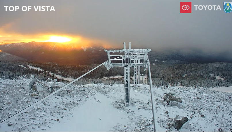
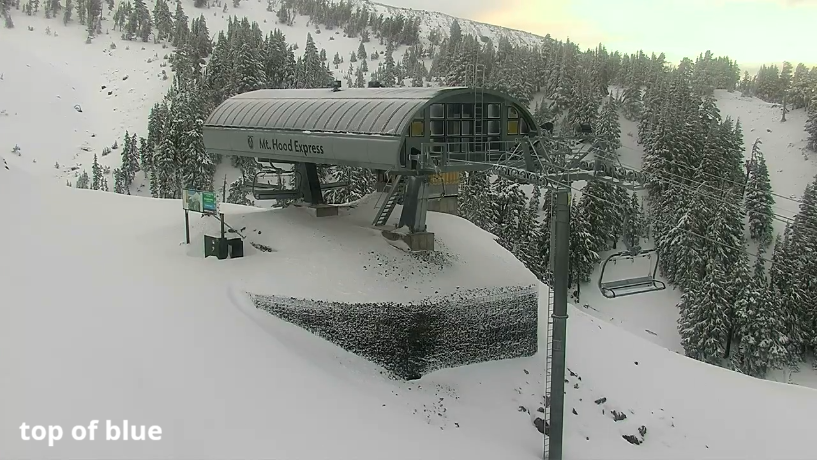
Hey skiers and snowboarders! What you see on Mt. Hood is what you get – Timberline Lodge has 13” at their snow stake, and Meadows has about 5” at the base. Snowfall looks much deeper on the Top Of Blue cam at Meadows. It’s so nice to see all that snow! That’s it for now – dry, cloudy weather lingers for a few days. That’s probably (75% chance) followed by dry, warmer weather for much of next week. Models are hinting at rain for Mt. Hood starting next weekend.
In the meantime… Thursday will be sunny. The free air freezing level rises from 2500′ to 4500′. Wind will be light and variable. Friday will be cloudy. The free air freezing level ranges from 4000′ to 4500′. Wind will be southerly 5-15mph. Saturday starts cloudy, adds a few snow flurries, and turns partly cloudy. The snow level will be 4000-4500′. Wind S 10-15 becoming E 10 then NW 15. Sunday looks cloudy then sunny. The snow level will be 4000′ with NW wind at 15-20mphduring the day.
Starting Monday, the free air freezing level rises to 10,000′, and temps warm back above freezing. Beyond that, there’s no sign of snow in the forecast – temps are forecast to be too warm. We’ll keep watching the forecast, and I”ll see you when there’s another round of snow on the way!
BARE BONES HOOD RIVER WEATHER FORECAST
Cloudy this morning. Partly cloudy this afternoon. Temps start in the low 40s and rise to the low 50s. Light and variable wind. No rainbows. Friday will be cloudy then mostly sunny. Temps start in the low 30s and rise to the low 50s. Light and variable wind in the morning. Light westerlies later. No rainbows. Saturday will be partly Nothing then partly cloudy. Temps start in the upper 20s and rise tot he mid 50s. Light easterlies. No rainbows.
BIKE TRAILS INFO
NEXT WORK PARTY: November 8th in Post Canyon with the HRATS.
CLOSED TRAILS: Anything south of the 44 Road due to the Grasshopper Fire / Forest Closure Order: for example – Boulder Lakes, Gunsight, Gumjuwac, Lookout Mountain, 450, Fifteenmile.
TEMIRA’S AWESOME TRAVEL ADVISORY SERVICE
HYPERLOCAL WEATHER FORECAST FOR THE COLUMBIA GORGE
THE DALLES, HOOD RIVER, WHITE SALMON, TROUT LAKE, STEVENSON, CASCADE LOCKS, PARKDALE, ODELL, HUSUM, BZ, MILL A, WILLARD, GOLDENDALE, RUFUS, ARLINGTON, boardman
Good morning, neighbors! It’s Thursday, and there’s a report of icy conditions in High Prairie this morning. That probably means we have other locations where the road surface has cooled enough for ice to form. Be careful out there! Be careful out there between now and next spring! General weather conditions over the next few days look cool, cloudy, and mostly dry. Next chance for significant rain isn’t until next weekend – high pressure (75% chance) this week is likely to keep us dry.
I know you all are waiting for the Halloween forecast. Prior to that, ghosts and ghouls, we’ll talk about Glenwood. It’s 35 degrees there this morning. Up in Parkdale, it’s 30-35 degrees, and the Centerville/Goldendale area is right around 30. Y’all watch out for black ice, now, okay? Is it time to put on snow tires? For some of you, it might just be. Is it time for the annual debate over studded vs. studless tires? DEFINITELY! It’s also time for the annual conversation around heated hummingbird feeders.
Know what else it’s time for? Yes, it’s time for you to vote. Vote as if your country’s future depends on it. Speaking of… isn’t it wonderful that the United States is warmly welcoming a refugee under criminal investigation who fled his country to avoid prosecution? What? You don’t want to let criminals in? I’m talking about Bolsonaro – the defeated far-right Brazilian politician. What makes him okay and other refugees not okay? Anyway… the weather for today… mostly cloudy this morning and partly cloudy later. Max temps: low to mid 50s with light east wind.
Another cloudy, near-freezing morning is forecast Friday. I don’t know about you, but I’m SO READY for Friday! Way too many Zoom meetings this week! Morning temps: 30-35. Afternoon: 53-55. East wind will be 15-20mph near Stevenson in the morning. Afternoon: light west wind.
Mostly clear sky Saturday morning west of The Dalles allows temps to plummet. To the east: partly cloudy and slightly warmer. Most locations will be sub-freezing. Exceptions: windy zones west of Hood River and areas underneath any Nothing cloud that forms near the Nch’i Wana. Afternoon: partly cloudy and 52-55 degrees. East wind will be 15-20mph in the usual spots in the morning. Afternoon wind will be light/variable. There is a chance of a little drizzle in the morning between Rowena and Biggs, but the rest of the day will be dry. Trick or Treaters: happy! Homeowners: also happy, because they can give away the candy rather than being tempted by it.
Speaking of candy: have you noticed the increase in chocolate prices under the current administration? I SURE HAVE! Vote Blue – Make Affordable Chocolate Available! Make Halloween Affordable Again! Safe travels. -TATAS
JONES BEACH, SAUVIE ISLAND, & COAST FORECAST
DONE FOR THE SEASON. SEE YOU NEXT SPRING!

Leave a Reply