

GORGE WIND FORECAST
If you’re still seeing yesterday’s and it’s after 9am, try opening this in an incognito window AND/OR FLUSHING YOUR CACHE or do a do a hard refresh (Ctrl+Shift+R / Cmd+Shift+R)
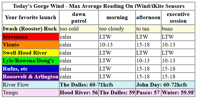
Keep in mind that this forecast attempts to predict what the iKite/iWind sensors will read. Think like a local! All sensors are not equal. Swell reads low. Viento/Arlington/The Wall read high compared to Swell. 30mph at Rufus (The Wall sensor) is about 23-24mph at Swell. 30mph at Swell is about 35-37mph at Rufus/Viento/Arlington. Hope that helps!
SHORT-TERM gorge wind forecast

Hi friends! The weather’s taken a turn towards winter (the snow level will be 5000′ or less this week!), which means the snowbirds are leaving, and the wind too is considering a cool-season vacation. But wait! A low pressure moving inland gives us a chance for desert westerlies on Tuesday! Other than that, active weather with a fair bit of rain doesn’t offer much hope…
Monday started with pressures of 30.00/30.01/30.01 for nearly-flat pressures and light/variable wind. As a weak cold front moves through midday, westerlies rise a bit: perhaps 10-13mph from Viento to Avery with 15-18mph from Maryhill to Boardman. Viento is also likely to see 15-18mph as this system moves through. River flow over the last 24 hours was 60-72kcfs, river temp is 59.9F, and high temp forecast is 56F with rain.

RIVER FLOW FOR SITES BETWEEN AVERY (EAST OF THE DALLES) AND RUFUS: CLICK HERE FOR JOHN DAY DAM FLOW.
RIVER FLOW FOR SITES BETWEEN STEVENSON AND DOUG’S BEACH (WEST OF THE DALLES): CLICK HERE FOR THE DALLES DAM FLOW

LONGER-TERM gorge wind forecast
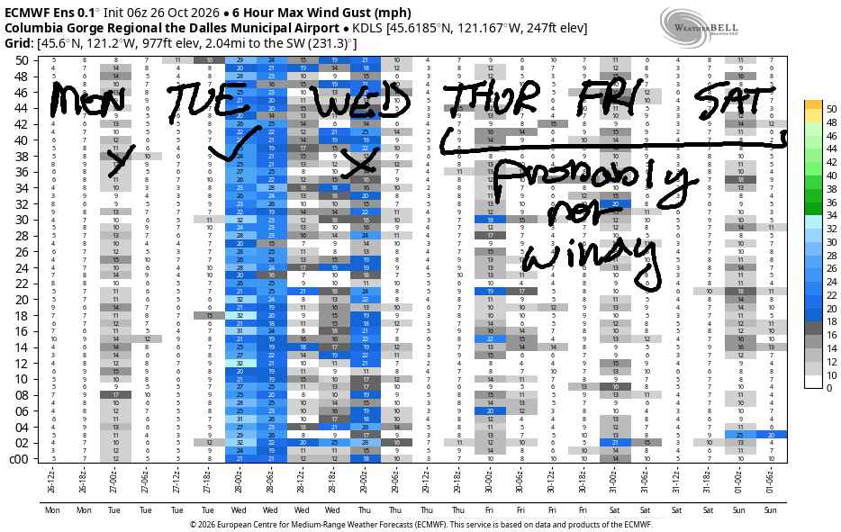
Another system moves through on Tuesday. In the aftermath, we’ll have stronger westerlies. Early wind will be under 10mph west of Avery and 15-18mph from Avery to Boardman. Areas from Avery to Boardman build to 21-24mph by late morning. Afternoon sees 25-28mph from Rowena or Avery (depends on clouds and rain) to Threemile and perhaps as far east as Boardman. High temp: 57F in Hood River and 60F in the desert.
Yet more action arrives on Wednesday in the form of yet more rain. Wind will be limited. Early westerlies will be 15-20mph between Iwash/Rooster (yes, westerly) and Viento. Westerlies fall to less than 10mph west of The Dalles in the afternoon with 15-28mph from Avery to Boardman. High temp: 52-55F. Cold!
Light/variable wind is likely Thursday and Friday. Beyond that, there are no clear signs of 15+ mph wind in either direction. Get what you can while you can! Hope to see you on the Nch’i Wana soon!
Tip via venmo, cash or check
Want to subscribe to the email version, support Temira, and get the forecast earlier? Click on the blue box up above or use the methods below. Year-round is $29.99 or more if you think it’s worth more. Only need snow or only need wind? Warm season (May-Oct) or cold season (Nov-Apr) is $19.99 or more if you think it’s worth more. Same for the cold season forecast. Thanks for your support!

JONES BEACH, SAUVIE ISLAND, & COAST FORECAST
DONE FOR THE SEASON! SEE YOU NEXT SPRING!
BARE BONES HOOD RIVER WEATHER FORECAST
Cloudy today with on and off rain through 5pm. Temps start in the mid 40s and rise to the mid 50s. Calm wind early. Light westerlies later. 98% chance of rainbows. Tuesday will be mostly cloudy with sprinkles during the morning, dry weather midday, and rain overnight. Temps start near 40 and rise to the upper 50s. Moderate westerlies. 86% chance of rainbows. Wednesday will be cloudy and rainy. Temps start in the upper 30s and rise to the low 50s. Light westerlies. 99% chance of rainbows.
BIKE TRAILS INFO
NEXT WORK PARTY: November 8th in Post Canyon with the HRATS.
CLOSED TRAILS: Anything south of the 44 Road due to the Grasshopper Fire / Forest Closure Order: for example – Boulder Lakes, Gunsight, Gumjuwac, Lookout Mountain, 450, Fifteenmile.
TEMIRA’S AWESOME TRAVEL ADVISORY SERVICE
HYPERLOCAL WEATHER FORECAST FOR THE COLUMBIA GORGE
THE DALLES, HOOD RIVER, WHITE SALMON, TROUT LAKE, STEVENSON, CASCADE LOCKS, PARKDALE, ODELL, HUSUM, BZ, MILL A, WILLARD, GOLDENDALE, RUFUS, ARLINGTON, boardman
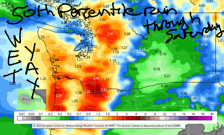
Good morning, neighbors! Geez – I take a day off from forecasting, and rain potential skyrockets! Since yesterday, significant rain fell: 0.22-0.44” in the Hood River Valley, 0.5” (ish) near Stevenson and Home Valley, and just about 0.1” near The Dalles. More is on the way! Also in the forecast: snow above 4000′ or so as temps at 850mb drop below 0C. Dry weather returns for this weekend and he early part of next week. Models then hint at potentially heavy rain late next week or next weekend. Yay! Rain!
It’s Monday, and it’s not so cold in Glenwood this morning thanks to all these clouds: 42 degrees was the start there. Intermittent drizzle makes it to The Dalles this morning and Hood River into the evening. South Wasco is likely to see drizzle much of today as well. As a low pressure system moves inland later, the rain turns showery tonight. Somewhere in the middle, we’ll have west wind at 15-20mph east of The Dalles with lighter wind to the west. Highs today will be in the mid to upper 50s with the snow level around 5000′.
Tuesday starts dry for most of us (exception: west of Cascade Locks between 2am and 8am) as the rainmaker sleeps in. Starting around 2pm, rain returns. Overnight, rain makes it as far east as Biggs or maybe even Arlington’s Triangle. After 8pm, commuters to/from the metro area will find heavy rain west of Stevenson – be prepared for hydroplaning and spray off the semis. Other Tuesday info: morning temps 40-45. Afternoon: 57-60. West wind builds to 15-20mph west of The Dalles and 20-30mph east of The Dalles. Snow level: 4500′ in the morning and 4000′ in the afternoon.
On Wednesday, we’ll have another round of drizzle, rainbows, and puffy-coat weather: morning temps are likely to be 40 or less pretty much everywhere. Afternoon: just 52-56. That’s cold enough for the snow level to fall to 3500-4000′. Be prepared for slushy conditions on Bennett Pass! Snow! Yay! Periods of rain continue on and off at least into Halloween with lingering chilly conditions. All of a sudden it’s winter, eh? Safe travels. -TATAS
HEY! DON’T STOP READING! Is this community-focused forecast helpful to you? It sure is! It takes me a couple hours a day to write. Please join your friends and neighbors in contributing to keep it going. Venmo: @thegorgeismygym PayPal: twomirrors@gmail.com USPS: Temira / PO Box 841 / Hood River, Oregon 97031
MT HOOD SNOW FORECAST

QR codes and links for end-of-season tips – thank you!!!
Cash/check: Temira – PO BOX 841 – Hood River, Oregon 97031



Leave a Reply