

GORGE WIND FORECAST
If you’re still seeing yesterday’s and it’s after 9am, try opening this in an incognito window AND/OR FLUSHING YOUR CACHE or do a do a hard refresh (Ctrl+Shift+R / Cmd+Shift+R)
SHORT-TERM gorge wind forecast

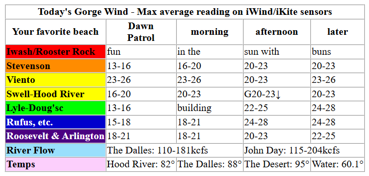
Hi friends! While today won’t be like yesterday (epic at the Hatch), it will be windy, and so will tomorrow! Yay! Wind speeds drop off on Sunday as heat wears away at the pressure gradients. Monday’s shaping up to be a rest day, but models are hinting at speeds bumping up again on Tuesday despite nearly 95 degree temps in Hood River. Before we dive in, a couple of things: one, congrats to all the racers from the Gorge Downwind Champs yesterday. Next, condolences to the friends and family of the individual who died windsurfing near Swell yesterday. It’s a small community, and we’re all impacted by death on the river. Do take care of each other in mourning and celebrating his life.
Friday started with pressures of 30.04/29.94/29.90 and westerlies running in the 15-18mph range most of the way from Stevenson to Arlington (Viento: 26, Stevenson, 12). Areas west of Wyeth were pretty socked in with clouds to start the day. All this is a good setup once the desert heat gets going! By late morning, we’ll have 20-23mph from Stevenson to Mosier with 17-20mph from Avery to Arlington. Westerlies build to 22-25mph from Stevenson to Doug’s by early afternoon with 17-20mph from Avery to Rufus and 12-15mph near Arlington. It’s likely the Hatch-Hood River zone will lose a few mph early afternoon as the metro area clears.
You can relocate if you want – desert heat gives us 24-28mph from Mosier to Rufus in the afternoon and evening with 20-23mph from Stevenson to Viento and 22-25 at Arlington. Hatch and Hood River – probably lighter and gusty in the afternoon thanks to metro area sunshine. Hatch and Hood River eventually rebuild to gusty 20-23mph in the evening. River flow over the last 24 hours was 110-204kcfs (115-204kcfs at Rufus), river temp is 69.1F, and high temp forecast is 82F in Hood River and 90F in the desert. Remember that sensors in Rufus/Arlington zone reads high and that this forecast predicts iWind/iKite sensor readings. 25 at the Hatch is about equal to 30 at Rufus, and 30 at the Hatch is about equal to 38 at Rufus. In other words, 25 is not the same everywhere!
RIVER FLOW FOR SITES BETWEEN AVERY (EAST OF THE DALLES) AND RUFUS: CLICK HERE FOR JOHN DAY DAM FLOW.
RIVER FLOW FOR SITES BETWEEN STEVENSON AND DOUG’S BEACH (WEST OF THE DALLES): CLICK HERE FOR THE DALLES DAM FLOW

LONGER-TERM gorge wind forecast
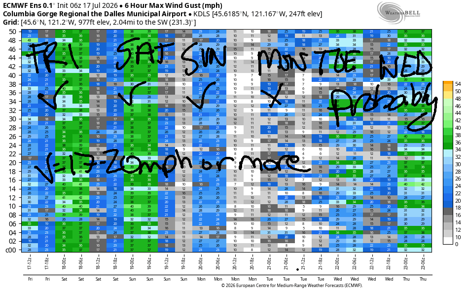
Moving on to Saturday, we have some marine clouds west of Cascade Locks to start the day, which gives the desert a bit of a bump in the heating game. Another solid day is on tap! Early wind will be 17-20mph from Stevenson to Hood River, 14-17mph from Mosier to Rowena, and 18-22mph from Avery to Arlington. By late morning, we’ll have 21-24mph from Stevenson to Mosier with 17-20mph from Lyle to Rufus and 10-13mph at Arlington. Hatch-zone wind falls mid-afternoon, but the other areas continue. As desert heating continues to support your fun, evening westerlies build to 24-27mph from Lyle to Arlington with gustier 20-24mph from Stevenson to Mosier. High temps range form 82 in Hood River to 90 out in the desert.
Sunday brings lesser wind as the metro area heat kicks in. Early westerlies will be 11-14mph from Viento to the Hatch with under 10mph elsewhere. By late morning or early afternoon, there should be enough wind for some of you: we’ll have a slow build to 17-20mph between Stevenson and Mosier with 13-16mph near Rowena. That wind persists into the evening. High temps: 90 in Hood River and 95 in the desert. Monday probably brings a rest day from windsports. The Euro ensemble hints at westerlies returning Tuesday and lingering into the far future. While the details aren’t clear, all signs point to “breezy”. Stay safe out there, folks. See you on the Nch’i Wana soon!

Was that helpful? I knew it was! Guess what? All of this crucial work – from your personal wind and snow reports to the invaluable TATAS updates – is made possible by my relentless efforts. Maintaining this labor of love isn’t easy. Each daily forecast takes hours. Website hosting, weather model access, and back-end admin work takes time and money. That’s where you come in.
YOUR CONTRIBUTION MAKES A DIFFERENCE
- SUPPORT ACCURATE, HYPER-LOCAL WEATHER FORECASTING
- ENABLE ACCESS FOR ALL, EVEN THOSE WITH LESS MEANS
- SUPPORT A COOL HUMAN WHO WORKS HARD SO YOU CAN PLAY
Take a moment to click one of the buttons below. Donate $19.99 or more (how much does this forecast enhance your life?) and get the email in your inbox. Whether it’s a renewing subscription (auto-renew) or a one-time donation, every contribution makes a real difference. Help me keep this labor of love alive, so we can all continue playing, commuting, and living in the Gorge with peace of mind and the best weather forecasts possible. Thank you!


Hood River, Oregon 97031


JONES BEACH, SAUVIE ISLAND, & COAST FORECAST
Wind northerly unless otherwise indicated. For coast, it’s North/Central/South with the “central” at approximately Florence. Swell forecast from NWS for central coast. Jones: westerly unless otherwise stated. Sauvie Island: northerly unless otherwise stated.
Coast Friday: LTNW/LTNW/n25, NW swell 4′ @ 7 seconds and W 3′ @ 17. Saturday: 15-20/20-25/25-30, NW 6′ @ 10 and W 2′ @ 15. Sunday: 15-20/20-25/30, N 6′ @ 7 and W 2′ @ 15. Jones Friday: 7-10. Saturday: 13-16. Sunday: 18-21. Sauvie Island Friday: 12-15. Saturday: 11-14. Sunday: 16-19.
BARE BONES HOOD RIVER WEATHER FORECAST
Sunny today. Temps start in the upper 50s and rise to the low 80s. Moderately strong westerlies. No rainbows. Saturday will be sunny. Temps start in the mid 50s and rise to the mi d80s. Moderately strong westerlies. No rainbows. Sunday will be sunny. Temps start in the upper 50s and rise to 90. Moderate westerlies. No rainbows.
TEMIRA’S AWESOME TRAVEL ADVISORY SERVICE
HYPERLOCAL WEATHER FORECAST FOR THE COLUMBIA GORGE
THE DALLES, HOOD RIVER, WHITE SALMON, TROUT LAKE, STEVENSON, CASCADE LOCKS, PARKDALE, ODELL, HUSUM, BZ, MILL A, WILLARD, GOLDENDALE, RUFUS, ARLINGTON, boardman
Good morning, neighbors! TGIF! For those of you who work the traditional workweek, you’re almost there! While you’re out and about this weekend, be kind to the folks who are busting their butts working – feeding you, selling you stuff, everything else that makes your weekend run smoothly. Weather this weekend: smooth as the swells on the Nch’i Wana yesterday. Generally speaking for the weekend weather, we’ll have warm, breezy conditions for folks west of The Dalles, and warm, less breezy conditions to the east.
Glenwood and today’s Gorge weather forecast
Friday kicked off spectacular in Glenwood: sunny and 40 degrees! Glenwood is the royalty of radiational cooling. Winning! The rest of us were a bit warmer, but plenty cool to chill our homes before the heat of the day. West of Hood River, the day starts cloudy. To the east: sunny. By day’s end, we’ll all have full sunshine. Temps rise to 79 in Stevenson, 82 in Hood River, 88 in The Dalles, and 95 in Pasco. West wind builds to 20-25mph this afternoon between Stevenson and The Dalles and fills in at 25mph from Stevenson to Arlington’s (natural) Triangle this evening. Looking around the world at the people we’re gonna make friends with (because threats of violence and war and genocide suck), we find the following weather:
Our friends around the world today!
Bandar-e Mahshahr, Iran: 108, sunny, 27% humidity
Havana, Cuba: 84, partly cloudy, 78% humidity
Muscat, Oman: 86, sunny, 76% humidity
Caracas, Venezuela: 72, partly cloudy, 83% humidity
Nuuk, Greenland: 50, rainy, 90% humidity
Gaza City: 87, sunny, 62% humidity
Ottawa, Canada: 65, cloudy, 60% humidity
Saturday’s Gorge weather forecast
Saturday looks a lot like Friday but a touch warmer. After a cloudy start west of Wyeth, the day turns clear for all. Early temps will be 55-60 degrees, mostly. Afternoon: 82/85/91/95. Along the river, westerlies start at 15-20mph between Viento and Mosier with 10-15mph east of Mosier to Boardman and also at Stevenson. Away from the river: light to start. Afternoon wind builds to 20-25mph and extends from Stevenson to Celilo Village with 15-20mph near Rufus and less to the east. Highs: 82/85/91/95.
Extended Gorge weather forecast
TATAS does not like heat. TATAS especially does not like it when the weather is 90+ degrees. Unfortunately, TATAS is going to have to suck it up starting Sunday as are the rest of us. After a 50-60 degree Sunday start, we’ll have 87/90/97/95 for highs. West wind will be under 10mph to start. Afternoon: 15-20mph from Stevenson to The Dalles.
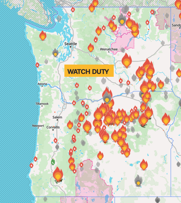
In the extended forecast, we have 90+ degrees for all of us through at least the middle of next week. Humidity increases starting Tuesday as southerly flow aloft drags in moisture. There are some signs of atmospheric instability in the middle of next week as moisture increases, southerly flow takes over, and a low (maybe) offshore potentially provides triggers. We’ll watch this closely. For now, there are no clear signs of heightened thunderstorm risk or damaging rain. We definitely don’t need more lightning – the last thunderstorms brought copious strikes and started countless fires (see watchduty image) across Oregon and Washington. Let’s cross our fingers for a bunch of rain as soon as cherry harvest is finished! Safe travels. -TATAS
HEY! DON’T STOP READING! Is this community-focused forecast helpful to you? It sure is! It takes me a couple hours a day to write. Please join your friends and neighbors in contributing to keep it going. Venmo: @thegorgeismygym PayPal: twomirrors@gmail.com USPS: Temira / PO Box 841 / Hood River, Oregon 97031 You can test out the forecast subscription for a few days for free by signing up below. Easy! Do it!
MT HOOD SNOW FORECAST

QR codes and links for end-of-season tips – thank you!!!
Cash/check: Temira – PO BOX 841 – Hood River, Oregon 97031