

MT HOOD SNOW FORECAST
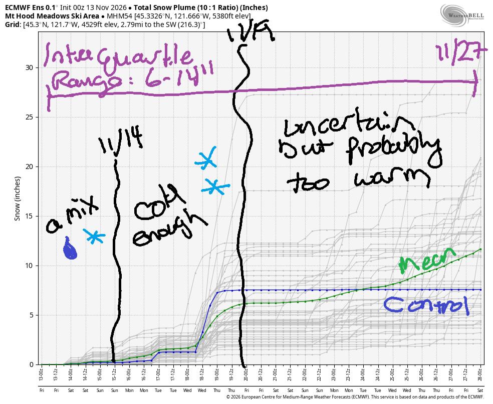
Hey skiers and snowboarders! It’s Friday! Snow levels fluctuate between too-high and low-enough through Sunday morning, after which they’ll be below 5000′ for several days. We’ll pick up under a foot of snow in that period; the most likely scenario is about 5”. Starting next Friday, temps will probably rise again and take the snow level back above 5000′ for the extended period, through the 27th of November. Just a heads up: I’m taking off on a meditation retreat on Sunday, so there will be a pause in the forecast until Tuesday, 11/24.
Let’s look at Friday, shall we? The snow level will be 7500′ in the morning, 6000′ in the afternoon, and 5000′ after midnight. About a quarter inch of rain falls during the day. Overnight, we pick up just 0.1” water equivalent (WE) for an inch of snow at 5000′. Wind will be S 20-40 this morning, S 10-20 this afternoon, and SW 20-40 after midnight.
Saturday starts with snow, but rising temps switch us over to mixed precip then rain. The snow level climbs from 5000′ in the morning to 8000′ in the evening and falls to 6500′ after midnight. Up to have an inch of moisture falls in that time period, mostly as rain. Wind: SW 15-20 much of the day rising to SW 30-50 after midnight.
Rain Sunday morning transitions to snow midday. The sky clears in the afternoon. Snow level: 6500′ early, 5000′ in the afternoon, and 3000′ under mostly clear sky overnight. Just a quarter inch of precip is forecast in that period for maybe an inch of snow at 5000′. Wind: SW 30-50 early becoming WSW 15 in the afternoon and W 10-15 overnight.
Looking at the extended forecast: flurries are likely on Monday. Dry weather returns Tuesday. During that time period, the freezing level should be under 5000′. A wetter system early Wednesday brings a few inches of snow with temps at 5000′ in the 28-30F range. Thursday looks dry and cool. Beyond that, uncertainty is present, but it’s likely temps will be too warm for snow at 5000′ through the 27th. That’s all for now. Keep practicing patience, and by patience, I mean dryland training! See you on the snow soon!

GORGE WIND FORECAST
If you’re still seeing yesterday’s and it’s after 9am, try opening this in an incognito window AND/OR FLUSHING YOUR CACHE or do a do a hard refresh (Ctrl+Shift+R / Cmd+Shift+R)
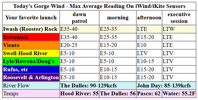
Keep in mind that this forecast attempts to predict what the iKite/iWind sensors will read. Think like a local! All sensors are not equal. Swell reads low. Viento/Arlington/The Wall read high compared to Swell. 30mph at Rufus (The Wall sensor) is about 23-24mph at Swell. 30mph at Swell is about 35-37mph at Rufus/Viento/Arlington. Hope that helps!
SHORT-TERM gorge wind forecast

Hi friends! I woke up super early this morning, and it was nuking at Stevenson and Iwash/Rooster. Nuking wind won’t stick around today, and there’s not much sign of wind in the next week or so. I’ll be gone from the 15th to the 23rd on retreat. Fortunately, it looks like there won’t be much in the Gorge wind forecast in that time period! I’ll probably do a forecast tomorrow (Saturday, 11/14), and then we won’t see each other again until the 24th.
Friday kicked off with gradients of 29.27/29.49/29.52 (whoa!) as a 960mb low spun offshore. Wind at 5am was 46mph at Iwash, 41mph at Stevenson, and 21mph at Viento. By sunrise, those easterlies will be down to 25-30mph at Stevenson and 25mph at Iwash Rock. The wind keeps fading. After 1pm, it’ll be below 10mph at Iwash and down to 15-20mph at Stevenson with easterlies at 15-20mph near The Dalles. After 4pm: light and variable all through the Gorge. River flow over the last 24 hours was 85-139kcfs, river temp is 55.2F, and high temp forecast is 55F with rain all morning and partly cloudy sky later.
RIVER FLOW FOR SITES BETWEEN AVERY (EAST OF THE DALLES) AND RUFUS: CLICK HERE FOR JOHN DAY DAM FLOW.
RIVER FLOW FOR SITES BETWEEN STEVENSON AND DOUG’S BEACH (WEST OF THE DALLES): CLICK HERE FOR THE DALLES DAM FLOW

LONGER-TERM gorge wind forecast
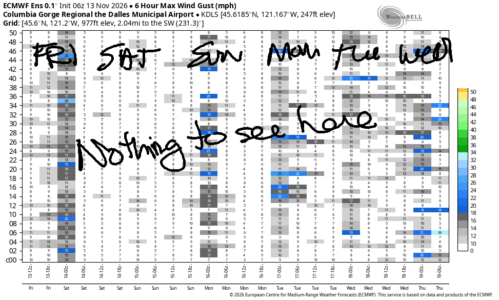
Saturday’s wind looks light and variable most of the day. After 4pm, easterlies build to 10mph at Stevenson, Iwash Rock, and Viento. High temp: 54F and partly cloudy.
Sunday sees yet another weather system swing through. Prior to dawn, we’ll have easterlies at 10-15mph at the usual spots. By daybreak, the wind turns light westerly west of Arlington. East of Arlington, there may be a few hours of gusty 15-18mph westerlies before the wind turns light out there too. High temp: 51 degrees. Light westerlies, under 10mph, are forecast on Monday. Tuesday starts light easterly and picks way up in the evening as another strong low spins off the coast. This could have some interesting implications for Wednesday’s Gorge weather, but you’ll have to read TATAS for that…
Tip via venmo, cash or check
Want to subscribe to the email version, support Temira, and get the forecast earlier? Click on the blue box up above or use the methods below. Year-round is $29.99 or more if you think it’s worth more. Only need snow or only need wind? Warm season (May-Oct) or cold season (Nov-Apr) is $19.99 or more if you think it’s worth more. Thanks for your support!

BARE BONES HOOD RIVER WEATHER FORECAST
Cloudy early, rainy midday, partly cloudy later. Temps start near 50 and rise to the mid 50s. Light to moderate easterlies. 71% chance of rainbows. Saturday will be partly cloudy. Temps start near 40 and rise to the mid 50s. Light and variable or calm wind. No rainbows. Rain overnight. Sunday will be rainy. Temps start near 40 and rise to 50ish. Light and variable wind. 67% chance of rainbows.
BIKE TRAILS INFO
NEXT WORK PARTY: Friday, November 13th at Family Man at 3pm with SQ Digs.
CLOSED TRAILS: Anything south of the 44 Road due to the Grasshopper Fire / Forest Closure Order: for example – Boulder Lakes, Gunsight, Gumjuwac, Lookout Mountain, 450, Fifteenmile.
TEMIRA’S AWESOME TRAVEL ADVISORY SERVICE
HYPERLOCAL WEATHER FORECAST FOR THE COLUMBIA GORGE
THE DALLES, HOOD RIVER, WHITE SALMON, TROUT LAKE, STEVENSON, CASCADE LOCKS, PARKDALE, ODELL, HUSUM, BZ, MILL A, WILLARD, GOLDENDALE, RUFUS, ARLINGTON, boardman

Good morning, neighbors! TATAS is so excited this morning. Sure, TATAS is about to leave for a week for an amazing meditation retreat with Matthew Brensilver and Gil Fronsdal (so no forecasts for a week), but more importantly, THERE’S SOMETHING INTERESTING IN THE FORECAST!!! Gorge weather has been decidedly unexciting since last January, and now, finally, we might see something interesting next Wednesday. Naturally TATAS won’t be here for it. SAD! Between now and next Tuesday night, we’ll continue with unseasonable warmth and intermittent rain. After Wednesday’s potential “incident”, we’ll likely have a few days of dry weather followed by a return to the dampness.
It is Friday morning, and TATAS will be busting their butt all day to clean their house for the housesitter. It’ll be a good day for it – rain is forecast. But first, let’s start with Glenwood. Up there in the hinterlands, Friday started 40 degrees. Elsewhere: right around 50 in many places, which is darn close to record high-lows. Those run about 50 degrees this time of year. Record high-highs are in the mid to upper 60s. Highs today will be be records, but they will be about 5 degrees above morning: 55 for areas from The Dalles westward and low 60s out in near the Tri-Cities. We’ll have light rain from Cascade Locks westward between 7am and 1pm and as far east as Biggs from 10am to 1pm. After that: partly to mostly cloudy and dry. OMG. So excited to see the sun after days of Nothing!!!
Today’s wind: 40mph out of the east early in the morning at Iwash (NOT a rooster) Rock and Stevenson quickly dropping to 15mph by sunrise and eventually turning light/variable in the late afternoon. In South Wasco County and nearby areas, you’ll have southerlies at 25-30mph today. TATAS is issuing a Rubbish Bin Warning – keep an eye on those trash cans, or they’ll be heading north at a rapid pace. The Dalles: easterlies at 15-20mph for a few hours this morning.
Saturday starts off drizzly west of Biggs with moderate to heavy rain west of Cascade Locks between 1am and 10am. Dry weather returns in the afternoon. Morning temps: 40-45. Afternoon: 54 in the weest, 57 in The Dalles, and 62 in the desert. Wind will be light and variable becoming easterly at 10mph near Stevenson in the afternoon.
Another rainy day is forecast on Sunday. That rain extends all the way to the Tri-Cities prior to dawn. For much of the day, it’ll be drizzly west of Lyle and east of Biggs with dry, partly cloudy weather in the middle. Morning temps: 40-45. Afternoon: 50-56. Wind: light and variable in the morning becoming light westerly in the afternoon.
Not much happens Monday (showery) or Tuesday (dry). Another beast of a low pressure system goes Beast Mode off the coast Tuesday night into Wednesday. It’s possible this one will drag in just enough cool-enough air for a wee bit of wet snow early Wednesday morning from 500′ on up. Elevated areas of Skamania, Klickitat, Hood River, Wasco, and Sherman Counties could see 1-3”. As of this morning, the timing looks perfect. Beyond that potential excitement, which is far from guaranteed, the weather looks dry for a couple of days then wet with seasonable temps. Safe travels. -TATAS
JONES BEACH, SAUVIE ISLAND, & COAST FORECAST
ON WINTER VACATION UNLESS DESPERATELY NEEDED.

Leave a Reply