

GORGE WIND FORECAST
If you’re still seeing yesterday’s and it’s after 9am, try opening this in an incognito window AND/OR FLUSHING YOUR CACHE or do a do a hard refresh (Ctrl+Shift+R / Cmd+Shift+R)

Keep in mind that this forecast attempts to predict what the iKite/iWind sensors will read. Think like a local! All sensors are not equal. Swell reads low. Viento/Arlington/The Wall read high compared to Swell. 30mph at Rufus (The Wall sensor) is about 23-24mph at Swell. 30mph at Swell is about 35-37mph at Rufus/Viento/Arlington. Hope that helps!
SHORT-TERM gorge wind forecast

Hi friends! If you’ve been looking for a big day in the desert, today’s the day! Get on it, because we’re looking at a light wind weekend. Moderate westerlies, perhaps in the teens, maybe up to 20mph, return Monday and potentially Tuesday, at which point significant uncertainty arrives in the Gorge wind forecast.
Friday started with light/variable wind and a deep, compact low pressures system poised to sweep inland mid-morning. When it does, wind speeds spike. You should feel confident driving pre-emptively today; if you’re seeing the super-nuker, you’ll want to be in position ahead of time – the full-nukage will lest for a few hours then fade to simply “strong”. Please consider a helmet and PFD today, and do keep an eye on your buddies. Experts-only conditions are on tap, and safety gear is highly advised.
After our zero-wind start, we’ll see quick build (9am?) to gusty 25-30mph from Stevenson to Mosier, gusty 15-25mph from Lyle to Doug’s, and gusty 30-33mph from Avery to Arlington at first. Add in some rain as far east as Biggs. After 11am (ish), westerlies drop to gusty 17-23mph (or less) between Stevenson and Doug’s and jump to 33-40mph from Avery all the way to Hermiston.
Best bet: Arlington to Threemile and beyond – it’s hard to know how gusty it will be at Rufus/The Wall – as this low moves inland, wind direction will shift; Arlington and Threemile will handle that better. After 2pm, the wind slowly fades; after 5pm, we’ll have 13-16mph from Stevenson to Doug’s with 29-33mph from Avery to Hermiston. River flow over the last 24 hours is 58-93kcfs, river temp is 66.2F, and high temp forecast is 60 in Hood River and 70 in the desert.

RIVER FLOW FOR SITES BETWEEN AVERY (EAST OF THE DALLES) AND RUFUS: CLICK HERE FOR JOHN DAY DAM FLOW.
RIVER FLOW FOR SITES BETWEEN STEVENSON AND DOUG’S BEACH (WEST OF THE DALLES): CLICK HERE FOR THE DALLES DAM FLOW

LONGER-TERM gorge wind forecast
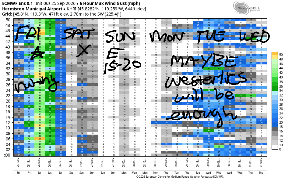
Saturday starts with light westerlies, under 10mph. The wind quickly turns calm and then switches to E 10-15mph at Iwash, Stevenson, Home Valley, and Viento. High temp: 66 in Hood River.
Sunday brings a slight chance of strong-enough easterlies to get some folks on the river. Early wind will be 20-25mph at Iwash/Rooster Rock and 15-20mph at Stevenson and Viento. In the afternoon, the wind fades away to nothing. High temp: 69 in Hood River.
A somewhat warmer day in The Dalles on Monday invites the westerlies back. As of this morning, the forecast suggests 15-18mph. Tuesday looks similar, but it’s way less certain – there’s quite a bit of range in the high temp forecast, which leaves the Gorge wind forecast uncertain as well. That’s about as far as I can get you for now. Stay safe out there today!
Tip via venmo, cash or check
Want to subscribe to the email version, support Temira, and get the forecast earlier? Click on the blue box up above or use the methods below. Year-round is $29.99 or more if you think it’s worth more. Only need snow or only need wind? Warm season (May-Oct) or cold season (Nov-Apr) is $19.99 or more if you think it’s worth more. Thanks for your support!

JONES BEACH, SAUVIE ISLAND, & COAST FORECAST
Wind northerly unless otherwise indicated. For coast, it’s North/Central/South with the “central” at approximately Florence. Swell forecast from NWS for central coast. Jones: westerly unless otherwise stated. Sauvie Island: northerly unless otherwise stated.
Coast Friday: S40->W15/LTV/N20, W swell 10′ at 10 seconds and SW 2′ @ 14. Saturday: 20/20-25/25-30, NW 6′ @ 9 and SW 2′ @ 13. Sunday: 15-20/20/25, N 3′ @ 5 and NW 4′ @ 9. Jones Friday: 7-10. Saturday: calm. Sunday: 10-13. Sauvie Island Friday: S30 → W 15. Saturday: N13-16. Sunday: 11-14.
BARE BONES HOOD RIVER WEATHER FORECAST
Cloudy early then rainy and windy then drizzly/showery. Temps start in the upper 50s and only rise to 60. Light west wind early, then strong, then moderate. 99.94% chance of rainbows. Saturday will be cloudy then partly high overcast. Temps start in the low 40s and rise to the mid 60s. Light and variable wind. No rainbows. Sunday starts partly Nothing then turns clear. Temps start in the low 40s and rise to the upper 60s. Light easterlies then calm. No rainbows.
BIKE TRAILS INFO
NEXT WORK PARTY: October 25th and November 8th in Post Canyon with the HRATS.
CLOSED TRAILS: Anything south of the 44 Road due to the Grasshopper Fire / Forest Closure Order: for example – Boulder Lakes, Gunsight, Gumjuwac, Lookout Mountain, 450, Fifteenmile.
TEMIRA’S AWESOME TRAVEL ADVISORY SERVICE
HYPERLOCAL WEATHER FORECAST FOR THE COLUMBIA GORGE
THE DALLES, HOOD RIVER, WHITE SALMON, TROUT LAKE, STEVENSON, CASCADE LOCKS, PARKDALE, ODELL, HUSUM, BZ, MILL A, WILLARD, GOLDENDALE, RUFUS, ARLINGTON, boardman

Good morning, neighbors! It’s Friday, yippee! A windy, windy day is on tap for the Gorge along with actual rain for everyone west of Bob’s Texas T-Bone (Rufus). After today’s weather excitement, you’ll probably want some calm. Can do – much quieter weather is forecast for the weekend. Caveat: we do have a chance of a light frost for some areas Saturday and Sunday morning, and Glenwood could see temps drop to the low 30s if all factors light up just right/wrong.
Glenwood was not cold this morning. Like the rest of us, it was warm: 52 degrees. And later, it will be windy! As a matter of fact, we’ll all get windy today, especially folks at elevation and/or on the downwind side of east-facing hills: Parkdale, Odell, Trout Lake, High Prairie, Snowden, Centerville, Goldendale, The Dalles, Dufur, Maupin, and other areas on the east side of the Cascade Crest. And the rest of you – you’ll be windy too – you just don’t have an official wind advisory. Why all the wind? A low pressure system moves inland this morning and into the desert this afternoon. In its wake, we’ll see 30+ mph wind all along the Nch’i Wana. Watch out near Viento this morning where super-strong wind could uproot some trees and blow cars around. Ditto from The Dalles eastward from late morning on. If your rubbish bin is outside this morning, post watch on it. It’s going eastward if it’s not tied down.
We’ll also have rain today: heavy west of Hood River from 8am-2pm and light to Biggs in the same time period. Rainfall tapers off into the afternoon and turns showery; we can’t rule out a thunderstorm or two. High temps: 57 in Stevenson, 60 in Hood River, 67 in The Dalles, and 72 in Pasco.
Everything calms down overnight into Saturday as the low exits the region. We’re left with light wind, partly cloudy sky, 850mb (5000′) temps at +2/+3C and dewpoints at 25-42. This puts Glenwood at risk of 30-33 degrees if it’s clear. Other locations that could drop below 36 if they have clear sky: Trout Lake, Snowden, High Prairie, Centerville, Goldendale, Steele Road area of The Dalles, and Dufur. Along the Nch’i Wana, a Nothing cloud is very likely Saturday morning as well as low clouds west of Mosier. Afternoon brings mostly clear sky with a few high clouds and temps from 65 to 69, warmest from The Dalles eastward. Wind will be westerly under 10mph early, calm midday, and light easterly in the afternoon, strongest near Stevenson and Iwash (dick) Rock.
Sunday morning brings similar frost risk despite somewhat warmer temps aloft – we’ll have east wind, dry air, and less chance of cloud cover. Nothing (cloud) is planned near the Nch’i Wana. Head to Iwash, Stevenson, and Viento for morning easterlies at 15-20mph. Elsewhere, the wind will be pretty much calm all day. By afternoon, the wind turns light and variable, perfect for some late-season nak*d tanning at Iwash Rock. Highs: 69-72.
Monday looks a little warmer both in the morning and afternoon. West wind returns at 15mph. Uncertainty climbs on Tuesday – a weak weather system might bring a little rain, and it might not. That’s all I have for you today. Safe travels. -TATAS
HEY! DON’T STOP READING! Is this community-focused forecast helpful to you? It sure is! It takes me a couple hours a day to write. Please join your friends and neighbors in contributing to keep it going. Venmo: @thegorgeismygym PayPal: twomirrors@gmail.com USPS: Temira / PO Box 841 / Hood River, Oregon 97031
MT HOOD SNOW FORECAST

QR codes and links for end-of-season tips – thank you!!!
Cash/check: Temira – PO BOX 841 – Hood River, Oregon 97031