

GORGE WIND FORECAST
If you’re still seeing yesterday’s and it’s after 9am, try opening this in an incognito window AND/OR FLUSHING YOUR CACHE or do a do a hard refresh (Ctrl+Shift+R / Cmd+Shift+R)
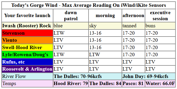
Keep in mind that this forecast attempts to predict what the iKite/iWind sensors will read. Think like a local! All sensors are not equal. Swell reads low. Viento/Arlington/The Wall read high compared to Swell. 30mph at Rufus (The Wall sensor) is about 23-24mph at Swell. 30mph at Swell is about 35-37mph at Rufus/Viento/Arlington. Hope that helps!
SHORT-TERM gorge wind forecast

Hi friends! It’s Friday – thanks for giving me the day off from the Gorge wind forecast yesterday. Today we’ll have moderate westerlies. Easterlies arrive this weekend, strongest prior to noon both days. Models hint at some sort of west wind Monday and Tuesday and potentially Wednesday. We’ll probably see easterlies on Thursday followed by a chance at a stronger west wind day sometime in the Friday to Sunday period next week as the weather turns cooler.
Friday started out nearly calm with small gradients: 30.03/30.01/30.01 for light onshore flow. We’ll have a couple hours of calm wind this morning for you to road bike and enjoy the quiet. Westerlies slowly build into the afternoon as a weak weather system transits far to the north of us. We should see 13-16mph from Stevenson to the Hatch by midday with 17-20mph from Stevenson to Avery after 2pm and lingering into early evening. River flow over the last 24 hours was 69-96kcfs, river temp is 66.0F, and high temp forecast is 79F and sunny.

RIVER FLOW FOR SITES BETWEEN AVERY (EAST OF THE DALLES) AND RUFUS: CLICK HERE FOR JOHN DAY DAM FLOW.
RIVER FLOW FOR SITES BETWEEN STEVENSON AND DOUG’S BEACH (WEST OF THE DALLES): CLICK HERE FOR THE DALLES DAM FLOW

LONGER-TERM gorge wind forecast
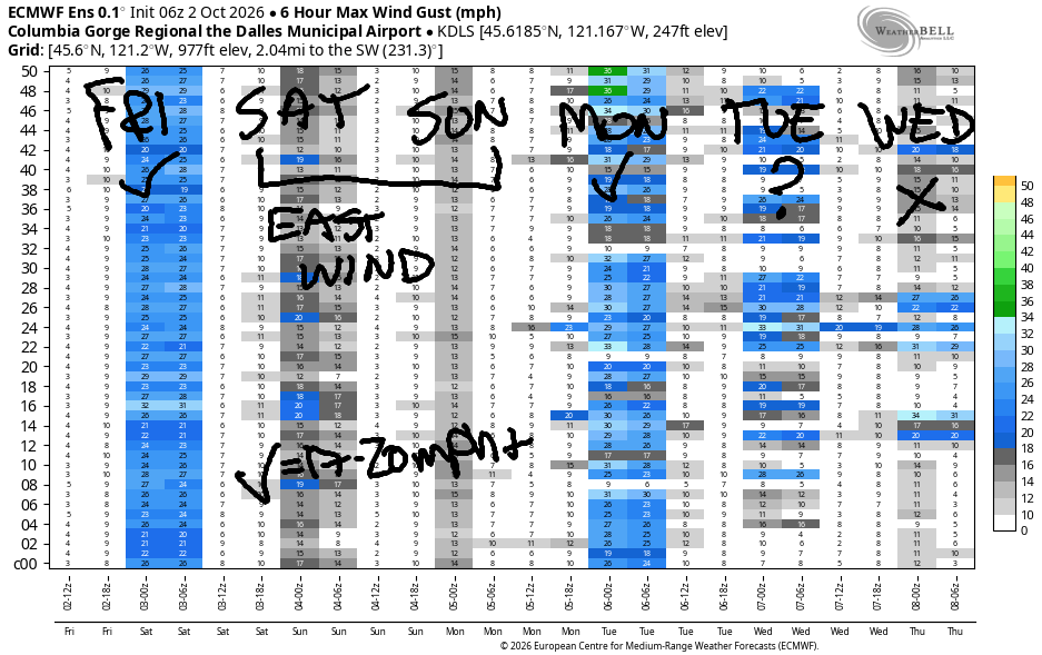
On Saturday, high pressure builds overhead and fires up fall easterlies. Early wind will be 25mph near Iwash, Stevenson, Home Valley, and Viento. You’ll have a few hours to get your fill. After 11am, the begins to fade. Those locations finish the day at 15mph. Between Swell and Mosier, the wind will be under 10mph all day. From Rowena eastward, the wind rises to 10mph out of the east. High temp: 79.
Sunday brings easterlies again, but they’ll fade faster. Early wind will be 20-25mph at the usual east wind spots. By 11am, it’ll be down to 15-20mph. Afternoon: 15mph at Stevenson and 10mph at Iwash, eventually dropping below 10mph. High temp: 82 degrees.
As of this morning, models suggest westerlies at 20-23mph or so between Stevenson and Hood River with Mosier and Rowena areas eventually joining in. High temp: 80. Models are less certain about Tuesday’s wind – it’s likely to be westerly, and it’s likely to be lighter than on Monday. Same for Wednesday – lighter yet. Models hint at easterlies for Thursday. This warm, sunny pattern may break down next Friday or sometime on the weekend which would likely result in a stronger westerly day. Have a wonderful day, everyone. Hope to see you on the Nch’i Wana soon!
Tip via venmo, cash or check
Want to subscribe to the email version, support Temira, and get the forecast earlier? Click on the blue box up above or use the methods below. Year-round is $29.99 or more if you think it’s worth more. Only need snow or only need wind? Warm season (May-Oct) or cold season (Nov-Apr) is $19.99 or more if you think it’s worth more. Thanks for your support!

JONES BEACH, SAUVIE ISLAND, & COAST FORECAST
Wind northerly unless otherwise indicated. For coast, it’s North/Central/South with the “central” at approximately Florence. Swell forecast from NWS for central coast. Jones: westerly unless otherwise stated. Sauvie Island: northerly unless otherwise stated.
Coast Friday: LTNW/N10-15/N25-30, W swell 4′ at 9 seconds. Saturday: 15-20/15/25, W 4′ @ 9. Sunday: 15-20/20/15-20, W 3′ @ 9. Thursday: only the North coast will be >15mph. Friday: Only the south coast. Jones Friday: LTW> Saturday: LTW. Sunday: 12-15. Sauvie Island Friday: 11-14. Saturday: 11-14. Sunday: 8-11.
BARE BONES HOOD RIVER WEATHER FORECAST
Sunny today. Temps start in the upper 40s and rise to the upper 70s. Calm wind early. Moderate westerlies later. No rainbows. Saturday will be sunny. Temps start near 50 and rise to the upper 70s. Light to moderate easterlies. No rainbows. Sunday will be sunny in the morning with a few clouds in the afternoon. Temps start in the low 50s and rise to the low 80s. Light easterlies in the morning. Calm in the afternoon. No rainbows.
BIKE TRAILS INFO
NEXT WORK PARTY: Saturday, October 3rd on Hospital Hill / Burdoin: Meet at 9am at the ball fields in White Salmon, corner of Tohomish and O’keefe. Work Party is 9am-1:30pm. Bring hedge trimmers, loppers, gloves, water. Sunday October 25 and November 8 with the HRATS in Post Canyon.
CLOSED TRAILS: Anything south of the 44 Road due to the Grasshopper Fire / Forest Closure Order: for example – Boulder Lakes, Gunsight, Gumjuwac, Lookout Mountain, 450, Fifteenmile.
TEMIRA’S AWESOME TRAVEL ADVISORY SERVICE
HYPERLOCAL WEATHER FORECAST FOR THE COLUMBIA GORGE
THE DALLES, HOOD RIVER, WHITE SALMON, TROUT LAKE, STEVENSON, CASCADE LOCKS, PARKDALE, ODELL, HUSUM, BZ, MILL A, WILLARD, GOLDENDALE, RUFUS, ARLINGTON, boardman
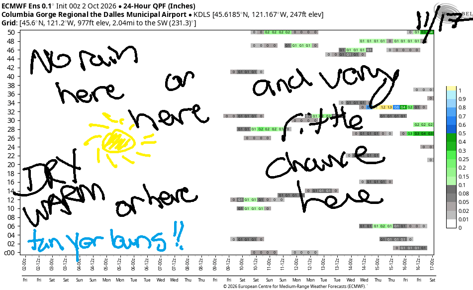
Good morning, neighbors! Warm, sunny, dry weather continues through at least next Friday. Temps will be well above normal with a slight chance of setting a record high on Monday (we did set a record high-low a couple days ago!) During this extended warm period, we’ll have a mix of east wind and west wind. In response, the Wicked Witch Of The East and the Wicked Warlock Of The West will come together in the Gorge, bump uglies, and make wicked babies (because two wrongs don’t make a right). Want to prevent wicked things in the world? Start by cultivating your own inner goodness!
Things are pretty darn good out there to start this TGIF – clear sky, calm wind, and 37 degrees in Glenwood. By afternoon, we’ll all be warm and sunny. Highs: 77 in Stevenson, 79 in Hood River, 84 in The Dalles, and 81 in Pasco. The wind goes from calm (may your heart be like this morning’s wind) this morning to 15-20mph between Stevenson and Avery this afternoon. To the east: light wind all day – perfect tanning weather (is tanning still a thing?)
ON Saturday morning, most of the Gorge will be clear, but a few high clouds will add some color to the sky east of The Dalles. A colorful sunrise is the equivalent of Mother Nature blushing. She’s blushing because the morning will be cold enough 45-55 degrees, for everyone of all genders to have perky nipples. Mother Nature blushes easily. What can I say? Afternoon: 79 in Stevenson and Hood River, 84 in The Dalles, and 82 in Pasco. We’ll have east wind at 20-25mph for the first half of the day at Iwash (tan your dong) Rock, and between Stevenson and Viento. In the afternoon, easterlies rise to 10mph east of Mosier and in the Hood River Valley (thanks to downsloping) and drop to 15mph from Viento westward.
Sunday looks very similar overall. Differences: temps a couple degrees warmer, and wind that dies off earlier. On Monday, a weak (not enough weightlifting) weather system well to the north drives temps down just a couple of degrees. In response, west wind returns at 20-25mph west of The Dalles. Temps drop a few more degrees on Tuesday (highs 76-82) and westerlies fall to 15-20mph. Similar weather is forecast Wednesday. Thursday: sunny with east wind.
As we look to the end of next week, models hint (but do not promise) at a stronger weather system that might bring cooler weather and could (low probability) bring a little rain. Honestly, there’s no clear sign of any significant rain in the next couple of weeks. That’s fine. It’s coming. Super El Niño and its super water-carrying capacity will come through at some point. Safe travels. -TATAS
HEY! DON’T STOP READING! Is this community-focused forecast helpful to you? It sure is! It takes me a couple hours a day to write. Please join your friends and neighbors in contributing to keep it going. Venmo: @thegorgeismygym PayPal: twomirrors@gmail.com USPS: Temira / PO Box 841 / Hood River, Oregon 97031
MT HOOD SNOW FORECAST

QR codes and links for end-of-season tips – thank you!!!
Cash/check: Temira – PO BOX 841 – Hood River, Oregon 97031

