

GORGE WIND FORECAST
If you’re still seeing yesterday’s and it’s after 9am, try opening this in an incognito window AND/OR FLUSHING YOUR CACHE or do a do a hard refresh (Ctrl+Shift+R / Cmd+Shift+R)
SHORT-TERM gorge wind forecast
Hi friends! West wind returns today and offers you a respite from hot dryland activities. High temps fall 11 degrees on Thursday, but it’s not The Cooldown You Were Looking For. Even so, stronger westerlies are in the cards. Ditto on Friday, as a trough (cool air) settles in and even drags some rain into the Gorge wind forecast. Westerlies continue into the middle of next week with the “proper” setup (when steadier, long-lasting, strong conditions are likely) for at least a couple days to start next week. We’ll get into more details down below.
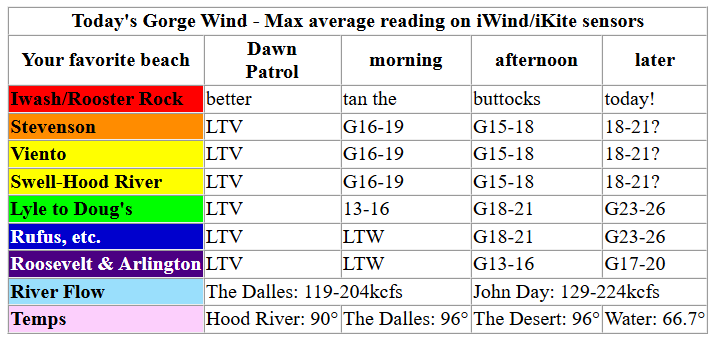
Starting with Wednesday… pressures early in the morning were 30.03/29.96/29.96, indicating a Corridor day (Viento to Hood River). But wait! A weak trough moves inland today for a late day, near-east nudge. Early wind was light/variable despite the 0.07 onshore gradient. By late morning, we’ll have 16-19mph from Stevenson to Mosier with 12-15mph from Lyle to Doug’s. As this system sneaks inland late morning or early afternoon, Hatch wind suffers – it’ll drop to gusty 15-18mph while Stevenson, Viento, and related areas build to 18-21mph. Between Mosier and Doug’s, you’ll find 18-21mph.
Thermal gradients and moderate offshore high pressure later today help in the wake of the system moving through; after 2pm, we’ll find gusty 23-26mph from Mosier to Blalock with 16-19mph near Arlington. Models suggest a possible rebound to 18-21mph at the Hatch after 5pm – that’s for you after-work folks! River flow over the last 24 hours was 119-224kcfs (129-224 at Rufus), river temp is 66.7F, and high temp forecast is 90F for Hood River and 96F east of The Dalles.
RIVER FLOW FOR SITES BETWEEN AVERY (EAST OF THE DALLES) AND RUFUS: CLICK HERE FOR JOHN DAY DAM FLOW.
RIVER FLOW FOR SITES BETWEEN STEVENSON AND DOUG’S BEACH (WEST OF THE DALLES): CLICK HERE FOR THE DALLES DAM FLOW

LONGER-TERM gorge wind forecast
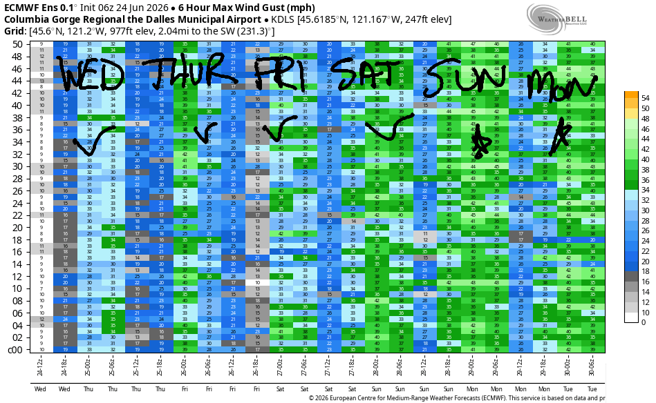
Somewhat stronger, gusty westerlies visit the Gorge on Thursday as a low moves towards BC and a cold front progresses eastward across the coastal waters. Early wind will be gusty 17-20mph from Viento to Mosier, 12-15mph near Rowena, and gusty 18-21mph from Avery to Arlington. The wind dips after Dawn Patrol and rebounds late morning. When the rebound happens, we’re expecting gusty 16-19mph from Stevenson to Hood River with gusty 25-28mph from Mosier to Threemile, strongest from Lyle to Arlington; the Avery to Arlington zone could intermittently rise to 28-31mph, but it’s going to be up-and-down.
Models once again point at an Executive Session rebound at the Hatch Thursday evening: 18-21mph. In the desert, from Avery to Arlington, there’s a decent chance of 28-31mph for the Executive Session thanks to the robust thermal gradient: high temps range from 79F in Hood River to 90F way out east.
A weather system swings through on Friday and drags some actual rain into the Gorge. Early wind, thanks to the drizzle, will be under 10mph all through the Gorge. Continued clouds and intermittent drizzle west of The Dalles will make for unreliable conditions between Stevenson and Doug’s; that said, there could be brief periods of “enough” wind. Look to the east for stronger, steadier wind aided by NW flow aloft. After 2pm, you’ll find 27-30mph from Avery to Threemile. High temps: 66F in Hood River and 79F in the desert. Nice thermal support! Caveat: atmospheric instability will be present and could potentially disrupt wind quality.
Unseasonably cool air and an unseasonably strong trough settles overhead on Saturday. Thermal gradients maintain the onshore flow, but instability may disrupt wind quality again. Early wind will be under 10mph west of The Dalles and in the teens to the east. Afternoon: 26-29mph from Lyle to Arlington. Highs: 63-75F.
Additional moving pieces on Sunday combine with increasing offshore high pressure and continued onshore thermal gradients for another mid-to-upper 20s day east of The Dalles. True “Classic Gorge Setup” is likely to settle in Monday and Tuesday for strong, steadier west wind with highs around 70F. It ain’t gonna be perfect the next six days, but it’s definitely going to be a decent stretch of westerlies. It’ll for-sure be nice to lose some of the heat. Have fun out there! See you on the Nch’i Wana soon!

Was that helpful? I knew it was! Guess what? All of this crucial work – from your personal wind and snow reports to the invaluable TATAS updates – is made possible by my relentless efforts. Maintaining this labor of love isn’t easy. Each daily forecast takes hours. Website hosting, weather model access, and back-end admin work takes time and money. That’s where you come in.
YOUR CONTRIBUTION MAKES A DIFFERENCE
- SUPPORT ACCURATE, HYPER-LOCAL WEATHER FORECASTING
- ENABLE ACCESS FOR ALL, EVEN THOSE WITH LESS MEANS
- SUPPORT A COOL HUMAN WHO WORKS HARD SO YOU CAN PLAY
Take a moment to click one of the buttons below. Donate $19.99 or more (how much does this forecast enhance your life?) and get the email in your inbox. Whether it’s a renewing subscription (auto-renew) or a one-time donation, every contribution makes a real difference. Help me keep this labor of love alive, so we can all continue playing, commuting, and living in the Gorge with peace of mind and the best weather forecasts possible. Thank you!


Hood River, Oregon 97031


JONES BEACH, SAUVIE ISLAND, & COAST FORECAST
Wind northerly unless otherwise indicated. For coast, it’s North/Central/South with the “central” at approximately Florence. Swell forecast from NWS for central coast. Jones: westerly unless otherwise stated. Sauvie Island: northerly unless otherwise stated.
Coast Wednesday: LTNW/NNW10-13/N25-30, NW swell 4′ @ 7 seconds. Thursday: SW5-10/LTV/N10-15, SW 2′ @ 17 and NW 3′ @ 7. Friday: W10-15/LTW/LTNW, SW 2′ @ 4 and W 5′ @ 8. Jones Wednesday: 24-27. Thursday: LTW. Friday: LTW. Sauvie Island Wednesday: 14-17. Thursday: 10-13. Friday: LTV.
BARE BONES HOOD RIVER WEATHER FORECAST
Partly high cloudy this morning. Partly mid and high cloudy this afternoon. Temps start in the mid 50s and rise to the low 90s. Moderate westerlies. No rainbows. Thursday will be High cloudy then mostly cloudy with a little drizzle possible after midnight. Temps star tint he upper 50s and rise to the upper 70s. Moderate westerlies. No rainbows. Friday will be cloudy then mostly cloudy. Temps start in the mid 50s and rise to the mid 60s. Light westerlies. 88% chance of rainbows.
TEMIRA’S AWESOME TRAVEL ADVISORY SERVICE
HYPERLOCAL WEATHER FORECAST FOR THE COLUMBIA GORGE
THE DALLES, HOOD RIVER, WHITE SALMON, TROUT LAKE, STEVENSON, CASCADE LOCKS, PARKDALE, ODELL, HUSUM, BZ, MILL A, WILLARD, GOLDENDALE, RUFUS, ARLINGTON, boardman
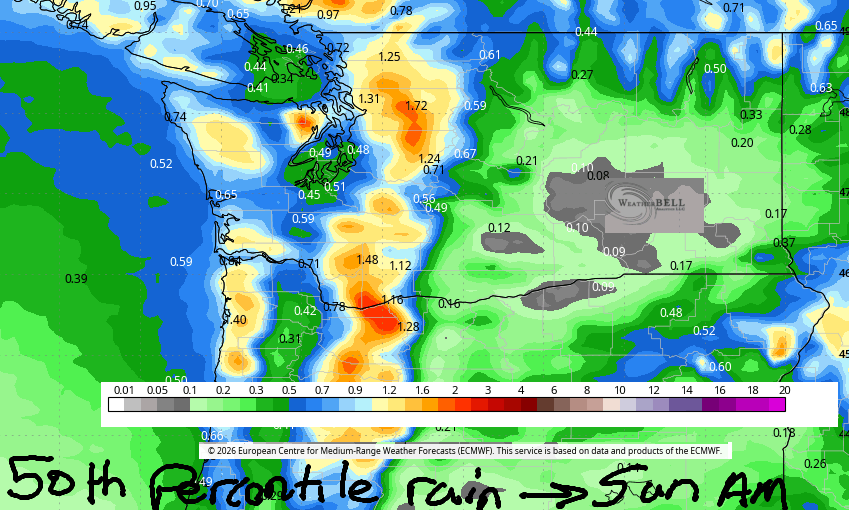
Good morning, neighbors! Last night I was at a friend’s house on the Heights until late, and then I went to my house in the lowlands, and I swear it was 15 degrees cooler on the Heights! It’s 6:30am right now, and all my windows and doors are open trying to cool down my home. You should do the same. Fortunately, this is the last day of heat for a while – cold air drops down from Alaska and Canada (THANK YOU, FRIENDS!) starting tomorrow and really settles in over the weekend. Next chance of hot weather isn’t until the end of next week. Rain: we’ll see a little with this system, but thankfully for cherry farmers, available moisture dropped in the last 24 hours. We’re expecting a trace in the desert, about 0.10” in The Dalles, up to 0.25” for the west side of Hood River (less on the east side) and up to 1.0” in the Cascades. We’ll refine those numbers tomorrow, okay?
Temps this morning were generally running 50-60 degrees with Glenwood at 45F (very nice!) and Middle Mountain at 66F (a bit hot for TATAS’ taste). Around the world, in places feeling the ire of POTUS, we have…
Tehran, Iran: 97, sunny, 12% humidity
Havana, Cuba: 83, sunny, 80% humidity
Muscat, Oman: 92, sunny, 74% humidity
Caracas, Venezuela: 70, cloudy, chance of rain, 87% humidity
Nuuk, Greenland: 39, partly cloudy, 89% humidity
Gaza City: 85, sunny, 63% humidity
Ottawa, Ontario, Canada: 65F, sunny, 67% humidity
Roads so far this morning appear to be free of !CE, snow, banana peels, and other slippery conditions.
Around here today – not quite as muggy as those places, but definitely on the sticky side. We end up partly cloudy this afternoon with temps ranging from 90F in Hood River to 96F from The Dalles eastward. West of The Dalles, the dewpoint will be around 50F this afternoon as a weak system swings through. This will turn on the westerlies enough to make it feel a little cooler. West wind builds to 15-20mph west of the Dalles and 20-25mph from Mosier to Rufus. Farther east: less wind and more Bighorn Sheep!
Thursday starts 50-60 degrees and partly high overcast. Pretty sunrise warning! Deeper clouds plow into the Gorge midday Thursday ahead of an incoming system, and a bit of drizzle is forecast overnight west of Hood River, near The Dalles, and east of Blalock Canyon. Afternoon: 76F in Stevenson, 79F in Hood River, 84F in The Dalles, and 90F in the desert. Doing the math… that’s 14 degrees from the west side to the desert. Wind likes this. Early westerlies will be 20-25mph west of Lyle with 10-15mph from Lyle to the Arlington Triangle. Afternoon wind will be 15-20mph west of Lyle and 25-30mph from Lyle to Boardman.
Much cooler air settles in on Friday. Available moisture spikes. We start the day with intermittent drizzle as far east as The Dalles and temps in the mid 50s. Cloud extend far past The Dalles. Early wind will be under 10mph all through the Gorge. Afternoon: under 15mph west of The Dalles and 25-30mph east of The Dalles, or perhaps east of Rufus, all the way to Boardman. In a fun twist, the snow level falls to 6000′ late Friday. If you’re missing snowfall, head to Timberline and run around catching snowflakes in your mouth. Best part of Friday: keeping the windows open all day long!
Even cooler conditions are forecast on Saturday, when highs will range from 61F to 75F. Showers continue. These will be less organized than Friday’s drizzle and more likely to contain a boom or two of thunder. West wind continues at 15-20mph west of Lyle and 25-30mph to the east. Sunday looks similar, but shower potential drops. Cool, breezy weather continues into the middle of next week. Safe travels. -TATAS
HEY! DON’T STOP READING! Is this community-focused forecast helpful to you? It sure is! It takes me a couple hours a day to write. Please join your friends and neighbors in contributing to keep it going. Venmo: @thegorgeismygym PayPal: twomirrors@gmail.com USPS: Temira / PO Box 841 / Hood River, Oregon 97031 You can test out the forecast subscription for a few days for free by signing up below. Easy! Do it!
MT HOOD SNOW FORECAST

QR codes and links for end-of-season tips – thank you!!!
Cash/check: Temira – PO BOX 841 – Hood River, Oregon 97031


Leave a Reply