

GORGE WIND FORECAST
If you’re still seeing yesterday’s and it’s after 9am, try opening this in an incognito window AND/OR FLUSHING YOUR CACHE or do a do a hard refresh (Ctrl+Shift+R / Cmd+Shift+R)
SHORT-TERM gorge wind forecast
Hi friends! It’s Friday, Juneteenth, TGIF, and here’s your Gorge wind forecast… We’re planning on a hot day with afternoon westerlies. Windier, cooler weather returns on Saturday thanks to a wiggle in the jet stream that moves into British Columbia. Moderate westerlies linger into Sunday before a couple days (or more?) of easterlies to start next week. Models suggest westerlies return middle to late next week, but strength and timing are unclear.
Juneteenth started off with gradients of 29.86/29.84/29.86 and light/variable wind. We’ll see a slow build into the afternoon as a shortwave moves towards BC and creates an onshore temp gradient by nudging the ridge/heat low into the desert. Given the forecast of highs in the 90s today, it’s going to be nothing short of a blow dryer out there!
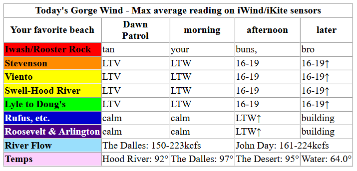
By late morning, westerlies rise to 10-13mph from Stevenson to Viento. They slowly build to 16-19mph this afternoon (with the Hatch potentially a bit less) from Stevenson to Doug’s. Models suggest stronger, more widespread westerlies late in the day, (up to 21-24mph from Stevenson to Doug’s with 24-27mph from Avery to Arlington), but I strongly suspect this won’t happen until after dark. That’s usually how this scenario plays out. River flow over the last 24 hours was 150-224kcfs, river temp is 64.0F, and high temp forecast is 92F for Hood River and mid 90s in the desert.
RIVER FLOW FOR SITES BETWEEN AVERY (EAST OF THE DALLES) AND RUFUS: CLICK HERE FOR JOHN DAY DAM FLOW.
RIVER FLOW FOR SITES BETWEEN STEVENSON AND DOUG’S BEACH (WEST OF THE DALLES): CLICK HERE FOR THE DALLES DAM FLOW

LONGER-TERM gorge wind forecast
Saturday starts off with a nice Dawn Patrol for TJ, Eddy, and Tom: westerlies at 25-28mph from Viento to Boardman with clouds west of the Hatch and lighter wind at Stevenson. Westerlies hold at 25-28mph into early afternoon but pull back to Arlington leaving Threemile and Boardman lighter. Don’t despair! From mid-afternoon on, the wind dips to 23-26mph from Stevenson to Hood River (maybe – if the clouds linger, the nuking continues), and rises to 29-34mph from Mosier to Arlington with 23-26mph at Threemile and 17-20mph at Boardman. That large range of wind mostly accounts for sensor reading disparities; we’ll see upper 20s near Rowena and low to (occasionally) mid 30s out east. High temps range from 77F in Hood River (down 15 degrees from Friday) to 91F in the desert.
Sunday sees high pressure excited to take back over – temps rebound, and the wind dips. Still… Dawn Patrol at 17-20mph from Stevenson to Mosier seems possible. That wind continues for a few hours before heating knocks the wind down to 10-13mph. Afternoon westerlies return at 17-20mph from Stevenson to Doug’s. Offshore high pressure (1028mb) is just strong enough that we could see the wind exceed expectations in the morning. Fingers crossed. Before I forget… there’s a swap meet at Windance on Sunday morning, 8am to noon.
High pressure really latches on for Monday and Tuesday. This gives us light to moderate easterlies and temps that soar past 90 degrees. Model agreement falls apart on Wednesday when models hint at somewhat cooler temps but aren’t quite certain. Stronger signals for cooling exist in the Euro ensemble beyond Wednesday, but there’s still a 10 degree range in the high temps. All that said – there’s a decent west wind signal in the ensembles starting Wednesday and stronger west wind signals from Thursday through the following Sunday or Monday. Fingers crossed! See you on the Nch’i Wana soon!

Was that helpful? I knew it was! Guess what? All of this crucial work – from your personal wind and snow reports to the invaluable TATAS updates – is made possible by my relentless efforts. Maintaining this labor of love isn’t easy. Each daily forecast takes hours. Website hosting, weather model access, and back-end admin work takes time and money. That’s where you come in.
YOUR CONTRIBUTION MAKES A DIFFERENCE
- SUPPORT ACCURATE, HYPER-LOCAL WEATHER FORECASTING
- ENABLE ACCESS FOR ALL, EVEN THOSE WITH LESS MEANS
- SUPPORT A COOL HUMAN WHO WORKS HARD SO YOU CAN PLAY
Take a moment to click one of the buttons below. Donate $19.99 or more (how much does this forecast enhance your life?) and get the email in your inbox. Whether it’s a renewing subscription (auto-renew) or a one-time donation, every contribution makes a real difference. Help me keep this labor of love alive, so we can all continue playing, commuting, and living in the Gorge with peace of mind and the best weather forecasts possible. Thank you!


Hood River, Oregon 97031


JONES BEACH, SAUVIE ISLAND, & COAST FORECAST
Wind northerly unless otherwise indicated. For coast, it’s North/Central/South with the “central” at approximately Florence. Swell forecast from NWS for central coast. Jones: westerly unless otherwise stated. Sauvie Island: northerly unless otherwise stated.
Coast Friday: LTNW/LTNW/LTN, NW swell 8′ @ 10 seconds and SW 2′ @ 15. Saturday: LTNW/LTNW/N20-25, NW 7′ @ 10 and SW 2′ @ 15. Sunday: 15-20/20/25-35, NW 5′ @ 9 and SW 2′ @ 14. Jones Friday: 24-27. Saturday: 17-20. Sunday: 16-19. Sauvie Island Friday: 12-15. Saturday: 12-15. Sunday: 15-18.
BARE BONES HOOD RIVER WEATHER FORECAST
Most clear today. Temps start in the upper 50s (open windows) and rise to the low 90s (close windows). Light and variable wind early. Moderate westerlies later. No rainbows. Saturday will be partly cloudy then mostly clear. Temps start in the upper 50s (open windows) and rise to the upper 70s (windows?). Strong to very strong westerlies. No rainbows. Sunday will be partly cloudy then mostly clear. Temps start in the low 50s and rise to the mid 80s. Moderate westerlies. No rainbows.
TEMIRA’S AWESOME TRAVEL ADVISORY SERVICE
HYPERLOCAL WEATHER FORECAST FOR THE COLUMBIA GORGE
THE DALLES, HOOD RIVER, WHITE SALMON, TROUT LAKE, STEVENSON, CASCADE LOCKS, PARKDALE, ODELL, HUSUM, BZ, MILL A, WILLARD, GOLDENDALE, RUFUS, ARLINGTON, boardman
Good morning, neighbors! It’s Juneteenth. If you’re not-Black and wondering what to do today (other than enjoy a Federal holiday), here are some ideas: reflect on the lingering impact of slavery. Reflect on the racist ideas you’ve learned from living in a White-dominant culture and understand how racism against People Of Color is harmful to the hearts of folks of all colors. Make a vow to speak up when you hear people expressing racist sentiments. Talk about racism with your White friends – normalize these conversations! Learn about police violence and mass incarceration and disparities in sentencing and prosecution. Respectfully attend a Juneteenth celebration (Jackson Park starting at 3pm) with an open heart and mind. Say the names of Black folks killed by police, including 1 year old Kohen Wiley who was shot and killed by police last week because police suspected his mother of stealing diapers. Reflect. Learn. Open your heart. Grow.
On to the weather…
Hot weather lingers through much of the next five days. Exception: Saturday, when cooler weather takes over for a short respite from the heat. Around here, cooling often brings wind, and this is no exception. Strong west wind and high fire danger is in the cards for Saturday. Hotter, less windy, weather is planned for Sunday through Tuesday followed by some sort of cooling in the middle to latter half of next week. No clear sign of rain exists in the ensembles, although there’s a slight chance west of The Dalles next weekend. At this point, I’d call rain unlikely in the next two weeks. Let’s get the cherry harvest over and then it can rain all it wants!
I was looking at temps this morning and got a bit distracted by the fact that the entire state of Nevada is under a Red Flag Warning. We’re under a fire weather watch (almost certain to transform to a RFW) starting Saturday morning. Other morning news: Glenwood was 51F this morning, warmer than the north end of Parkdale, which was 49F. The rest of us were mostly 55-60 degrees to start the day. Get those windows and doors open and cool off your home, cuz heat is coming: Afternoon brings 92F in Hood River, 97F in The Dalles, and 95F out in the desert. Light wind starts the day. Afternoon brings 15-20mph from Stevenson to The Dalles. Westerlies build into the night and rise into the mid 20s overnight, all the way from Stevenson to the Arlington Triangle. Before we move into tomorrow’s weather, let’s check in with all our friends across the world today:
Our friends around the world today
Tehran, Iran: 93, sunny, 17% humidity
Havana, Cuba: 81, partly cloudy, 83% humidity
Muscat, Oman: 97, sunny, 52% humidity
Caracas, Venezuela: 72, partly cloudy, 84% humidity
Nuuk, Greenland: 39, partly cloudy, 92% humidity
Gaza City: 84, sunny, 52% humidity
Ottawa, Ontario, Canada: 63F, cloudy, 87% humidity
Saturday’s Gorge weather forecast
Saturday starts off blissfully cool (mid 50s) and cloudy west of Hood River with mostly clear sky and 60ish to the east. Afternoon temps rise to 75F in Stevenson, 77F in Hood River, 82F in The Dalles, and 91F in the desert. West wind will be 25-30mph all the way from Viento to Boardman in the morning. Westerlies persist west of Lyle at 25-30mph all day and build to 30-35mph from Lyle east to Arlington’s Triangle, whatever that is (someone told me it’s like the Bermuda Triangle, but for precipitation).
Sunday’s Gorge weather forecast
While Sunday will start with a few low clouds in the west and mostly clear sky to the east, it’ll quickly turn mostly clear everywhere with a few high clouds. Morning temps will be 50-60F. Afternoon: 84-90F. West wind west of The Dalles will be 15-20mph early, 10-15mph midday, and 15-20mph in the afternoon and evening. Westerlies stay below 10mph east of The Dalles from mid-morning on.
Extended Gorge weather forecast
Monday and Tuesday look hot and sunny as offshore (easterly) flow takes over. Highs on Monday range from 93-97F. Tuesday: 97-101F. There’s some small hint of a 10 degree drop in highs on Wednesday and a continued slide in highs day-over-day through next weekend, but there’s a ton of uncertainty in the models. I am crossing my fingers for cooler weather. “Normal” high temps for this time of year in Hood River are in the mid 70s. There’s little sign we’ll be averaging mid-70s over the next couple of weeks. It’s starting to look like another hot summer is on tap. Safe travels. -TATAS
HEY! DON’T STOP READING! Is this community-focused forecast helpful to you? It sure is! It takes me a couple hours a day to write. Please join your friends and neighbors in contributing to keep it going. Venmo: @thegorgeismygym PayPal: twomirrors@gmail.com USPS: Temira / PO Box 841 / Hood River, Oregon 97031 You can test out the forecast subscription for a few days for free by signing up below. Easy! Do it!
MT HOOD SNOW FORECAST

QR codes and links for end-of-season tips – thank you!!!
Cash/check: Temira – PO BOX 841 – Hood River, Oregon 97031


Leave a Reply