

GORGE WIND FORECAST
If you’re still seeing yesterday’s and it’s after 9am, try opening this in an incognito window AND/OR FLUSHING YOUR CACHE or do a do a hard refresh (Ctrl+Shift+R / Cmd+Shift+R)
SHORT-TERM gorge wind forecast
Hi friends! Big westerlies are on tap today along with cooler weather than yesterday. I forgot to dry my wetsuit – oops. Lesser westerlies linger on Sunday before the Gorge wind forecast turns easterly for Monday and Tuesday, when there’s unlikely to be enough to get you on the water. Models aren’t certain if we’ll see enough of a cooldown on Wednesday for big westerlies, but we should see westerlies return. Beyond that: cooler weather and day after day of west wind.
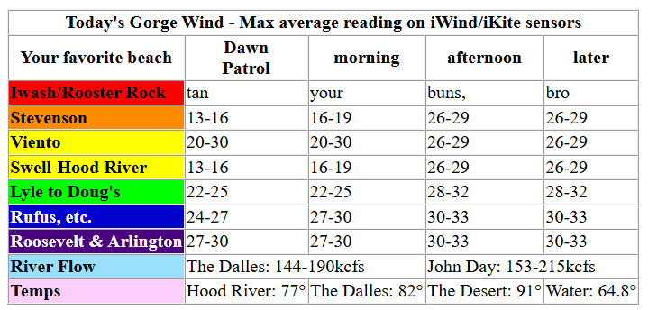
Saturday started with pressures of 30.00/29.85/29.76 and 1030mb (good) offshore. Gradients at 6am: 0.15(!) and 0.09 (good). With gradients like that, we should have wind all through the Gorge today! Early westerlies (8am – I woke up late) were in the teens at Stevenson through Hood River (32 at Viento), 20-25mph from Lyle to Rufus and at Threemile, and 30ish at Arlington. For the morning, your best results, 26-29mph, will be from Lyle to Arlington. West of the low clouds, the wind will be up and down and unreliable, except perhaps at Viento (gusty 20-30mph) which benefits from the passing of this weak system.
Afternoon sees the clouds burn back. This gives us 26-29mph from Stevenson to Mosier with 28-33mph from Lyle to Arlington. The lower readings will be on the iWind/iKite sensors near Rowena (those sensors just read lower), and the higher readings will be on the Rufus-Loroc sensors, which read higher. All that said, it looks like a great day in the Near East and Eastern Gorge with gustier, but still strong, wind west of Lyle. Yay! River flow over the last 24 hours was 144-215kcfs (153-215 at Rufus with that 215 reading late evening), river temp is 64.8F, and high temp forecast is 77F and clearing in Hood River and 91F in the desert. Now that I see that high temp in the desert, I wouldn’t be surprise if we see 33-36mph between Lyle and Arlington with 28-32mph at Threemile and 22-25mph at Boardman.
RIVER FLOW FOR SITES BETWEEN AVERY (EAST OF THE DALLES) AND RUFUS: CLICK HERE FOR JOHN DAY DAM FLOW.
RIVER FLOW FOR SITES BETWEEN STEVENSON AND DOUG’S BEACH (WEST OF THE DALLES): CLICK HERE FOR THE DALLES DAM FLOW

LONGER-TERM gorge wind forecast
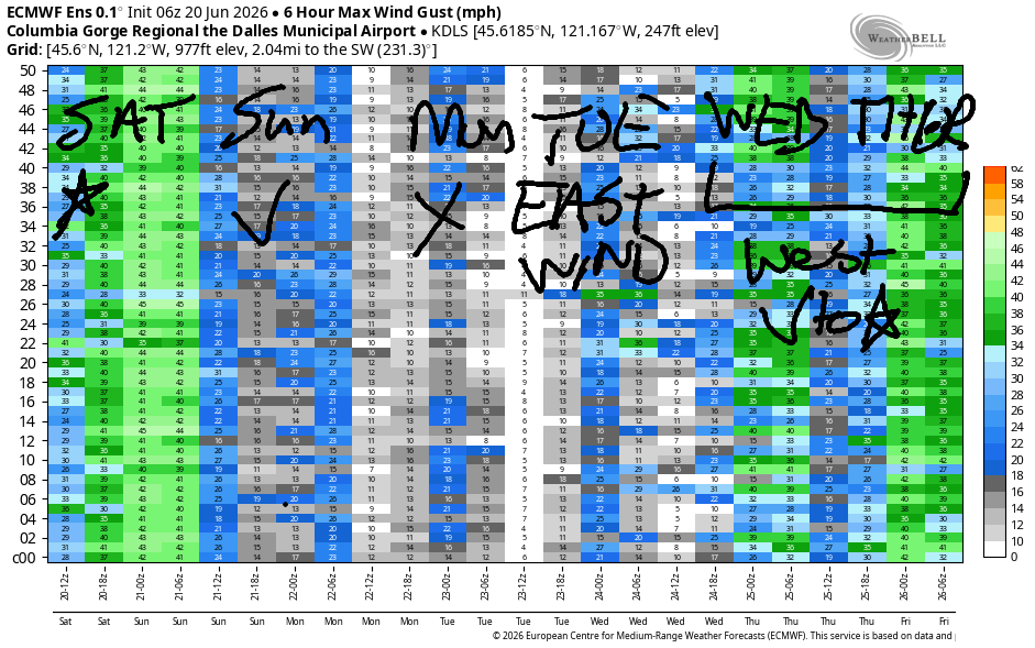
Sunday sees high pressure start to push into the PNW. Models do hint at morning marine clouds west of Hood River, which could lead to the wind over-performing. For now, we have a true Dawn Patrol (prior to 8am) at 16-19mph from Stevenson or Viento to the Hatch with lighter wind to the east. Models suggest the wind will drop quickly and land at 11-14mph by late morning, filling in from Stevenson to Hood River. Even lighter wind is forecast in the afternoon. That said… the morning marine clouds and offshore high pressure may be enough for a little more than forecast. High temp: 86F in Hood River.
Monday brings calm wind to start and a forecast of hot weather. Easterlies pick up to 15mph mid-morning near Stevenson, Home valley, and Viento with light/variable wind near Iwash/Rooster. Afternoon: E 5-10mph for all the spots between Iwash Rock and Viento. Light or calm wind will be found east of Viento. High temp: 93F. Tuesday morning looks a lot like Monday. Afternoon: 96 degrees with a switch to west wind late. 95% of the time these late-day westerlies under-perform, so don’t count on it. Just cross your fingers.
Westerlies return on Wednesday, but the strength is unclear. Just count on enough wind to get on the water. Ditto for the rest of the week and into the weekend, when the weather turns much cooler and brings a chance of rain. This hints at some good days out east. Fingers crossed – deets are far from clear this far out. See you on the Nch’i Wana soon!

Was that helpful? I knew it was! Guess what? All of this crucial work – from your personal wind and snow reports to the invaluable TATAS updates – is made possible by my relentless efforts. Maintaining this labor of love isn’t easy. Each daily forecast takes hours. Website hosting, weather model access, and back-end admin work takes time and money. That’s where you come in.
YOUR CONTRIBUTION MAKES A DIFFERENCE
- SUPPORT ACCURATE, HYPER-LOCAL WEATHER FORECASTING
- ENABLE ACCESS FOR ALL, EVEN THOSE WITH LESS MEANS
- SUPPORT A COOL HUMAN WHO WORKS HARD SO YOU CAN PLAY
Take a moment to click one of the buttons below. Donate $19.99 or more (how much does this forecast enhance your life?) and get the email in your inbox. Whether it’s a renewing subscription (auto-renew) or a one-time donation, every contribution makes a real difference. Help me keep this labor of love alive, so we can all continue playing, commuting, and living in the Gorge with peace of mind and the best weather forecasts possible. Thank you!


Hood River, Oregon 97031


JONES BEACH, SAUVIE ISLAND, & COAST FORECAST
Wind northerly unless otherwise indicated. For coast, it’s North/Central/South with the “central” at approximately Florence. Swell forecast from NWS for central coast. Jones: westerly unless otherwise stated. Sauvie Island: northerly unless otherwise stated.
Coast Saturday: LTNW/LTNW/N20-25, SW swell 7′ @ 10 seconds and SW 2′ @ 15. Sunday: 15-20/20/25-35, NW 6′ @ 9 and SW 2′ @ 15. Monday: 20/20/30-35, NW 6′ @ 9 and SW 2′ @ 14. Jones Saturday: 13-16. Sunday: 15-18. Monday: 13-16. Sauvie Island Saturday: 12-15 > 5pm. Sunday: 13-16. Monday: 16-19.
BARE BONES HOOD RIVER WEATHER FORECAST
Clouds this morning. Mostly clear this afternoon. Temps start in the upper 50s and rise to the upper 70s. Strong westerlies. No rainbows. Sunday will start with a few low clouds and turn mostly clear. Temps start in the low 50s and rise it the mid 80s. Moderate westerlies becoming light. No rainbows. Monday will be mostly clear with a few high clouds. Temps start in the mid 50s and rise to the low 90s. Light and variable wind. No rainbows.
TEMIRA’S AWESOME TRAVEL ADVISORY SERVICE
HYPERLOCAL WEATHER FORECAST FOR THE COLUMBIA GORGE
THE DALLES, HOOD RIVER, WHITE SALMON, TROUT LAKE, STEVENSON, CASCADE LOCKS, PARKDALE, ODELL, HUSUM, BZ, MILL A, WILLARD, GOLDENDALE, RUFUS, ARLINGTON, boardman
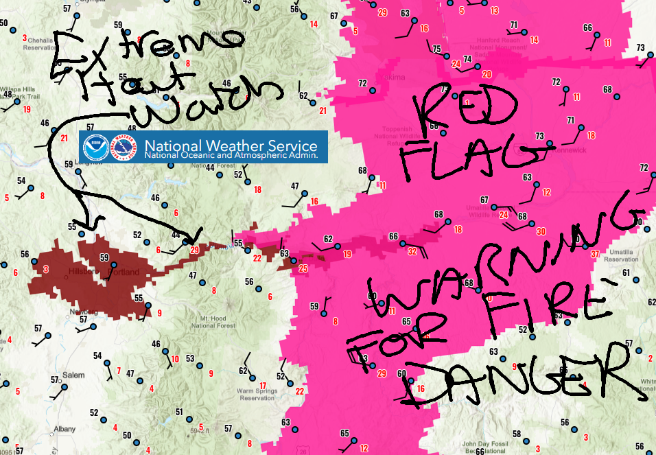
Good morning, neighbors! IT’S SO NICE RIGHT NOW IN HOOD RIVER!!! It’s a cloudy, cool start to the day which is darn refreshing. We’ll be back to sunshine and heat by Sunday with yet another Extreme Heat Watch posted for us starting Monday, when temps soar past 90. Don’t abandon all hope – models are insistent on much cooler weather to end next week and support us through next weekend. There’s even a chance of rain Friday into Saturday. Cherry farmers, I see you, and I’m keeping a close eye on the moisture. Road conditions: so far no !CE on the roads this morning – there are folks out looking in Hood River…
Glenwood this morning and our other friends around the world
The first thing that pops up on the NWS map this morning is a giant blob of hot pink – there’s a Red Flag Warning posted for areas east of Viento for extreme fire danger today. Do be careful out there, folks. Double-check your trailer chains, don’t mow or week whack with metal blades, and keep cigarette butts in the car. Next thing on the map: 55-60 degrees pretty much everywhere, even in Glenwood, where it’s 56F to start the day. Our friends around the world are mostly hot and mostly muggy, as per usual:
Tehran, Iran: 97, sunny, 14% humidity
Havana, Cuba: 83, partly cloudy, 80% humidity
Muscat, Oman: 96, sunny, 47% humidity
Caracas, Venezuela: 74, partly cloudy, 79% humidity
Nuuk, Greenland: 43, cloudy, 83% humidity
Gaza City: 83, sunny, 65% humidity
Ottawa, Ontario, Canada: 64F, cloudy, 81% humidity
Aren’t you glad you live in the Gorge?!??!
Today’s Gorge weather forecast
Today’s weather starts cloudy to the west and clear to the east and finishes sunny all around. Thanks to strong wind and relatively low humidity and dry fuels, fire danger will be extreme. Temps rise to 75F in Stevenson, 77F in Hood River, 82F in The Dalles, and 91F in the desert. West wind builds to 25-35mph all the way from Stevenson to the Arlington Triangle with 20-25mph farther east. There were two fires east of The Dalles yesterday – Maryhill and Blalock Canyon. Both are out, but that’s a sign of just how dry and dangerous it is out there already.
Sunday’s Gorge weather forecast
ON to Sunday… we start cloudy in the west with a few high clouds to the east and temps in the low 50s. Afternoon will be mostly sunny and 86-90F, warmest in The Dalles. Wind at dawn will be 15-20mph west of Mosier and light to the east. During the day, the wind fades and ends at 10mph west of Mosier and lighter to the east.
Monday’s Gorge weather forecast & the extended Gorge weather forecast
Monday looks mostly sunny, hot, and not very windy. After a mid 50s start, temps rise to the low 90s to the west and east of The Dalles and mid to upper 90s in The Dalles. Wind will be dead calm to start, east 10-15mph between Iwash (schlong) Rock and Viento midday, and under 10mph everywhere in the afternoon. Tuesday looks similar but a few degrees warmer – highs range from 96 to 100 degrees. Late in the day or sometime overnight, west wind returns.
This doesn’t result in much cooling by Wednesday – it’ll still be in the 90s – but it will be slightly cooler and windier. Temps continue to slide into next weekend, when we should top out in the 70s! TATAS loves this. TATAS is ambivalent about the rain – it’s possible we’ll see some Friday or Saturday, but it’s completely unclear how much. With cherry crops still on the trees, we do not want rain right now. After the cherries are harvested… we’ll take all the rain we can get. Speaking of cherry harvest and migrant workers, if you see !CE, please call PIRC at 888-622-1510 IMMEDIATELY. Put that number on speed dial right now, and share it with your friends. Help protect our community. Help protect your neighbors. Help protect our workers. Stand together against hatred and in compassion. Safe travels. -TATAS
HEY! DON’T STOP READING! Is this community-focused forecast helpful to you? It sure is! It takes me a couple hours a day to write. Please join your friends and neighbors in contributing to keep it going. Venmo: @thegorgeismygym PayPal: twomirrors@gmail.com USPS: Temira / PO Box 841 / Hood River, Oregon 97031 You can test out the forecast subscription for a few days for free by signing up below. Easy! Do it!
MT HOOD SNOW FORECAST

QR codes and links for end-of-season tips – thank you!!!
Cash/check: Temira – PO BOX 841 – Hood River, Oregon 97031


Leave a Reply