

GORGE WIND FORECAST
If you’re still seeing yesterday’s and it’s after 9am, try opening this in an incognito window
SHORT-TERM gorge wind forecast
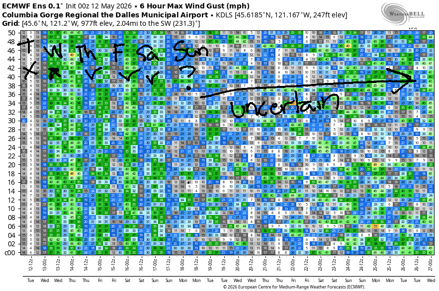
Hi friends! Looks like some fun planned for us over the next few days!!! I’m all jacked up and ready to ride! The fun starts this afternoon, as a cool trough drops down from Alaska and combines with the desert heat low for a massive gradient across the Cascades. (Almost) The Cooldown You Were Looking For is in the cards on Wednesday when NWS has an actual, honest-to-god High Wind WARNING posted for various local areas. Westerlies continue Thursday, Friday, and Saturday.
Tuesday, however, started with easterlies! Gradients were 29.88/30.00/30.02 to start the day with east wind at 35mph at Iwash/Rooster, 25mph at Stevenson, and 20mph at Viento. Get it early, because it’ll drop fast. By midday, Stevenson will be down to 10mph, and Iwash will be westerly at 10mph. West wind builds into the evening. For your executive session (after 5pm), you’ll find 27-31mph out of the west from Stevenson to Rufus. Please, please let this happen before dark! River flow over the last 24 hours was 214-256kcfs (239-256 at Rufus), river temp is 57.7F, and high temp forecast is 85F and dropping with the arrival of the westerlies.
RIVER FLOW FOR SITES BETWEEN AVERY (EAST OF THE DALLES) AND RUFUS: CLICK HERE FOR JOHN DAY DAM FLOW.
RIVER FLOW FOR SITES BETWEEN STEVENSON AND DOUG’S BEACH (WEST OF THE DALLES): CLICK HERE FOR THE DALLES DAM FLOW

LONGER-TERM gorge wind forecast
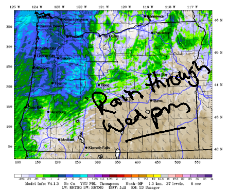
Wednesday starts out with actual drizzle all the way into the desert. Even so, we’ll start the day with gusty 17-20mph from Stevenson to Doug’s (more at Viento) and gusty 27-32mph from Avery to Boardman. After the rain stops, say after 11am, westerlies hold at gusty 17-20mph under the clouds west of Lyle. From Lyle eastward to Boardman, we’ll have 32-26mph with massive gusts. The wind starts to fade late afternoon and finishes at 27-30mph east of Mosier and 12-15mph west of Mosier. High temp: 63F in Hood River and 71F in the desert.
On Thursday morning, we’ll have light west wind and a little drizzle. Afternoon westerlies rise to gusty 15-18mph from Stevenson to Mosier with 22-25mph from Lyle to Arlington. Friday looks a bit stronger as offshore high pressure exerts more influence and the desert heats up just a bit. The forecast for Saturday is mid 20s, probably strongest out east. Sunday: probably lighter. Beyond that, uncertainty is too high to make any predictions, but this week should give you plenty of wind to keep you busy. See you on the Nch’i Wana soon!

Was that helpful? I knew it was! Guess what? All of this crucial work – from your personal wind and snow reports to the invaluable TATAS updates – is made possible by my relentless efforts. Maintaining this labor of love isn’t easy. Each daily forecast takes hours. Website hosting, weather model access, and back-end admin work takes time and money. That’s where you come in.
YOUR CONTRIBUTION MAKES A DIFFERENCE
- SUPPORT ACCURATE, HYPER-LOCAL WEATHER FORECASTING
- ENABLE ACCESS FOR ALL, EVEN THOSE WITH LESS MEANS
- SUPPORT A COOL HUMAN WHO WORKS HARD SO YOU CAN PLAY
Take a moment to click one of the buttons below. Donate $19.99 or more (how much does this forecast enhance your life?) and get the email in your inbox. Whether it’s a renewing subscription (auto-renew) or a one-time donation, every contribution makes a real difference. Help me keep this labor of love alive, so we can all continue playing, commuting, and living in the Gorge with peace of mind and the best weather forecasts possible. Thank you!


Hood River, Oregon 97031


JONES BEACH, SAUVIE ISLAND, & COAST FORECAST
Wind northerly unless otherwise indicated. For coast, it’s North/Central/South with the “central” at approximately Florence. Swell forecast from NWS for central coast. Jones: westerly unless otherwise stated. Sauvie Island: northerly unless otherwise stated. Coast Tuesday: W10/W5-10/LTS, W swell 4′ @ 11 seconds and 2′ @ 16. Wednesday: W15/W15/LTV, W 6′ @ 2 & 2′ @ 15. Thursday: SW 15/W10/N20-25, W 5′ @ 10 & 2′ @ 15. Jones Tuesday: 20-23. Wednesday: 10-13. Thursday: LTW. Sauvie Tuesday: 15-18. Wednesday: W 10-15. Thursday: 8-11.
BARE BONES HOOD RIVER WEATHER FORECAST
Partly high overcast today with increasing clouds this evening. Temps start in the mid 40s and rise to the mid 50s. Light easterlies early. Strong westerlies late. No rainbows. Wednesday will be cloudy with drizzle early and partly cloudy later. Temps start near 50 and rise to the low 60s. Moderate westerlies. 99% chance of rainbows. Thursday will be cloudy with a little drizzle early and dry weather later. Temps start in the upper 40s and rise to the upper 60s. Light to moderate westerlies. 99% chance of rainbows.
TEMIRA’S AWESOME TRAVEL ADVISORY SERVICE
HYPERLOCAL WEATHER FORECAST FOR THE COLUMBIA GORGE
THE DALLES, HOOD RIVER, WHITE SALMON, TROUT LAKE, STEVENSON, CASCADE LOCKS, PARKDALE, ODELL, HUSUM, BZ, MILL A, WILLARD, GOLDENDALE, RUFUS, ARLINGTON, boardman
Good morning, neighbors! All sorts of interesting weather is on tap this week. SO EXCITED! We’ll have blasting west wind starting this evening and continuing through tomorrow. Then we get some RAIN on Wednesday with SNOW in the Cascades along with super-duper strong wind east of Mosier. Cool weather continues into the weekend with a chance of frost on Thursday morning for select areas. Temps aloft will be cold enough for concern this weekend, but it looks like we’ll have enough cloud cover to protect us from frost. Fingers crossed. Final thing in the overview: it’s going to be very, very windy on Wednesday. Given that conditions are already dry, fire danger will be quite high. Please be very, very careful with sparks, flames, and anything else that could start a fire (accessing other dimensions, for example or launching space rockets or having sex outside).
Glenwood this morning
Looking around the Gorge this morning… Glenwood started the day at 37F, too warm for frost, and too cold to walk the dog naked. “Walk the dog” is not a euphemism; it just happens that people in Glenwood are so hardy that they often walk the dog sans clothes. They do wear shoes, because OSHA regulations say you need to wear shoes while dog-walking and everyone in Glenwood is a union member and follows all the OSHA rules. The rest of us (mostly) started the day at 45-50 degrees, except Middle Mountain, which woke up to 57F. Hot!
Today’s Gorge weather forecast
Speaking of hot, we’ll see warm temps today: 85F to the west, 90F in The Dalles, and 91F in the desert. That said… if the west wind arrives earlier than forecast, we might miss those targets. For the morning, we’ll have east wind at 35mph near Iwash (wiener) Rock and 25mph at Stevenson. The wind switches direction mid-afternoon and builds to 25-30mph out of the west from Stevenson to Rufus this evening. At least some high clouds stick around today, and the humidity ramps up in the evening making you feel sweaty and sticky.
Wednesday’s Gorge weather forecast
Overnight, we’ll have strong to very strong west wind all through the Gorge. Thanks to the wind, we’ll wake up to warmth: 50 degrees or so. Guess what else? Starting in the wee hours of Wednesday, we’ll have drizzle in the western Gorge that quickly spreads all the way east to Hermiston. Heavy rain is forecast between Multnomah Falls and Wyeth for a few hours in the morning, just in time for your drive to your city job. Rain ends east of The Dalles after 10am, and it ends in the western Gorge late afternoon.
Highs will be down TWENTY FUCKING DEGREES (!!!) from Tuesday, leaving us with 63F to the west, 68F in The Dalles, and 71F in the desert. Result: west wind at 30-40mph with gusts to 50+ east of Mosier. West side: way less wind, except at Viento, thanks to cloud cover. More Wednesday news: the snow level falls to 4500′, and up to 6” is forecast for 5000′ and above. That snowfall will be accompanied by very strong wind in the Cascades, Simcoes, etc. Wednesday is NOT a day to go hiking. Finally… well, I forgot what I was going to say… Oh, I was going to repeat what I said about fire danger.
Thursday’s Gorge weather forecast
Moving on to Thursday… We have a cloudy, drizzly start west of The Dalles with clear sky in the desert. For the afternoon, we’ll have clouds with dry conditions. The snow level starts around 4000′ and rises to 7000′. Wind will be light westerly, under 10mph. With temps at 850mb in the 0-2C range, elevated areas under clear sky (??Glenwood, Centerville, Goldendale, Dufur, east side of The Dalles??) are at some risk of frost. Otherwise, temps will be in the mid 40s most places. Clouds increase during the day, and temps make it to 68F-74F. West wind picks up to 15-20mph west of Mosier and 20-25mph between Mosier and Arlington.
Extended Gorge weather forecast
Unseasonably cool, sprinkly weather continues into the weekend. We’ll keep a VERY close eye on Sunday morning for the possibility of widespread frost. We’re currently expecting light wind, clear sky, a free air freezing level of 3000′, and 850mb temps at 0C. This is concerning. I’m making plans to cover my tomatoes, and I am holding off on planting peppers until after Sunday morning. That, of course begs the question of next week’s weather: uncertainty is present. Generally speaking, next week looks dry, warmer, and conducive to planting shit. Or to planting shit in shit, because plants like shit. Happy gardening. Safe travels. -TATAS
HEY! DON’T STOP READING! Is this community-focused forecast helpful to you? It sure is! It takes me a couple hours a day to write. Please join your friends and neighbors in contributing to keep it going. Venmo: @thegorgeismygym PayPal: twomirrors@gmail.com USPS: Temira / PO Box 841 / Hood River, Oregon 97031 You can test out the forecast subscription for a few days for free by signing up below. Easy! Do it!
MT HOOD SNOW FORECAST

QR codes and links for end-of-season tips – thank you!!!
Cash/check: Temira – PO BOX 841 – Hood River, Oregon 97031


