

GORGE WIND FORECAST
If you’re still seeing yesterday’s and it’s after 9am, try opening this in an incognito window AND/OR FLUSHING YOUR CACHE or do a do a hard refresh (Ctrl+Shift+R / Cmd+Shift+R)
SHORT-TERM gorge wind forecast
Hi friends! Yesterday proved a bit strange on the river with the swell only intermittently measuring up to the wind speed. It was a washing machine out there at times for sure! If that wore you out like it wore me out, rest well today. Moderate westerlies return Friday, strong wind is forecast Saturday, and we may round out the weekend with another moderate Corridor day in the Gorge wind forecast before heat and lesser wind return for a couple days.
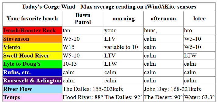
Thursday started off with lingering onshore gradients but not much wind: 30.03/29.95/29.96 (0.08/-0.01) with westerlies under 10mph everywhere except Viento, which was reading 15mph. Models give us a short period of 10-15mph this morning west of Mosier prior to the wind turning easterly at 10mph near Stevenson for a few hours midday. Afternoon: calm. River flow over the last 24 hours was 155-203kcfs, river temp is 63.3F, and high temp forecast is 88F and sunny.
RIVER FLOW FOR SITES BETWEEN AVERY (EAST OF THE DALLES) AND RUFUS: CLICK HERE FOR JOHN DAY DAM FLOW.
RIVER FLOW FOR SITES BETWEEN STEVENSON AND DOUG’S BEACH (WEST OF THE DALLES): CLICK HERE FOR THE DALLES DAM FLOW

LONGER-TERM gorge wind forecast
Friday starts out calm. Hottest temps shift to the desert on Friday afternoon, and that gives us hot thermals. By noon, westerlies build to 11-14mph from Stevenson to Hood River. Peak wind in the Corridor will be mid-afternoon at 18-21mph from Stevenson to Mosier. In the evening, the Stevenson-Hood River zone falls to 16-19mph, and Lyle to Avery rises to 19-22mph. High temp: 90F in Hood River and 96F in The Dalles.
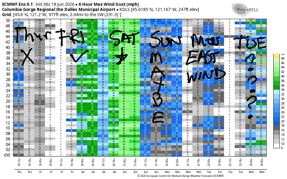
A shortwave/vort max moves into BC on Saturday and drags cooler air and marine clouds into the western Gorge. Heat lingers in the desert. High temps in Hood River fall from 90F Friday to 76F Saturday. This is The Cooldown You Were Looking For. Dawn Patrol starts with 26-29mph from Viento to Threemile and doesn’t back down. Afternoon: 25-28mph from Stevenson to Mosier with 28-32mph from Lyle to Arlington, 22-25mph at Threemile, and 20-23mph at Boardman. Highs range from 76F in Hood River to 90F in the desert.
Models have quite a bit of range for Sunday. For now, let’s call it upper teens. Light easterlies are forecast on Monday, Tuesday, and potentially Wednesday as another hot spell takes over. When that breaks, likely on Thursday, but possibly Wednesday, we should see another big west wind day. Enjoy your rest day. See you on the Nch’i Wana soon!

Was that helpful? I knew it was! Guess what? All of this crucial work – from your personal wind and snow reports to the invaluable TATAS updates – is made possible by my relentless efforts. Maintaining this labor of love isn’t easy. Each daily forecast takes hours. Website hosting, weather model access, and back-end admin work takes time and money. That’s where you come in.
YOUR CONTRIBUTION MAKES A DIFFERENCE
- SUPPORT ACCURATE, HYPER-LOCAL WEATHER FORECASTING
- ENABLE ACCESS FOR ALL, EVEN THOSE WITH LESS MEANS
- SUPPORT A COOL HUMAN WHO WORKS HARD SO YOU CAN PLAY
Take a moment to click one of the buttons below. Donate $19.99 or more (how much does this forecast enhance your life?) and get the email in your inbox. Whether it’s a renewing subscription (auto-renew) or a one-time donation, every contribution makes a real difference. Help me keep this labor of love alive, so we can all continue playing, commuting, and living in the Gorge with peace of mind and the best weather forecasts possible. Thank you!


Hood River, Oregon 97031


JONES BEACH, SAUVIE ISLAND, & COAST FORECAST
Wind northerly unless otherwise indicated. For coast, it’s North/Central/South with the “central” at approximately Florence. Swell forecast from NWS for central coast. Jones: westerly unless otherwise stated. Sauvie Island: northerly unless otherwise stated.
Coast Thursday: 20-25/20-25/20-25, NW swell 6′ at 9 seconds and SW 2′ @ 17. Friday: 15/10/LTV, NW 7′ @ 10, SW 2′ @ 16. Saturday: LTNW/NW10/N20-25, NW 7′ @ 9 and SW 2′ @ 15. Jones Thursday: 17-20. Friday: 24-27. Saturday: 15-18.
BARE BONES HOOD RIVER WEATHER FORECAST
Clear sky this morning. Temps start in the mid 50s and rise to the upper 80s. Calm wind or light/variable. No rainbows. Friday will be partly cloudy then clear. Temps start near 60 and rise to 90. Calm wind early. Moderate westerlies later. No rainbows. Saturday will be partly cloudy then mostly clear. Temps start in the upper 50s and rise to the mid 70s. Strong westerlies. No rainbows.
TEMIRA’S AWESOME TRAVEL ADVISORY SERVICE
HYPERLOCAL WEATHER FORECAST FOR THE COLUMBIA GORGE
THE DALLES, HOOD RIVER, WHITE SALMON, TROUT LAKE, STEVENSON, CASCADE LOCKS, PARKDALE, ODELL, HUSUM, BZ, MILL A, WILLARD, GOLDENDALE, RUFUS, ARLINGTON, boardman

Good morning, neighbors! A couple days of warm-to-hot, mostly sunny weather finish off this week. A brief cooldown on Saturday can’t hang on; we’re back to hot weather Sunday through at least next Tuesday. Cooler (but not cool) weather is likely to linger through the following weekend with a tiny chance of rain at the end of next week.
No rain today, tho. And it’s chilly to start the day in Glenwood – just 41 degrees. I wonder if folks in Glenwood sleep with the windows open. Research supports sleeping in a cool room. I do it when I can, but this morning the chill made it hard to get out of bed. The meowing cat convinced me. Anyway… checking in with friends around the world…
Tehran, Iran: 88, sunny, 22% humidity
Havana, Cuba: 83, sunny, 80% humidity
Muscat, Oman: 92, sunny, 66% humidity
Caracas, Venezuela: 71, partly cloudy, 86% humidity
Nuuk, Greenland: 41, cloudy, 92% humidity
Gaza City: 83, sunny, 59% humidity
Here in the Gorge, we’ll have a warm, sunny day with very little wind, which will make some of you very happy! Today’s high temps range from 87F in Stevenson to 92F in The Dalles and 90F in Pasco. Wind will be light westerly early, barely easterly (10mph in Stevenson) midday, and calm in the afternoon and evening.
Warm – 60 degrees or so – and partly cloudy sky starts Juneteenth. Attending the celebration at Jackson Park on Friday afternoon? Stay hydrated! If you can get up early enough for sunrise, do it! It’ll be a pretty one! And get your cool-weather stuff done early cuz it’s gonna be hot: 86F in Stevenson, 90F in Hood River, and 96F from The Dalles eastward. Calm wind starts the day. Westerlies build to 15-20mph from Stevenson to Avery in the afternoon and continue to climb overnight in response to…
A shortwave/vort max approaching and moving in to BC on Saturday drags clouds into the western half of the Gorge to start the day. This nudges the heat low to the desert and stabilizes the west side. All those words mean that it’s going to be 1) cooler and 2) much windier. Expect westerlies at 25-35mph all day from Viento to Boardman with Stevenson joining in at some point after the clouds burn off. Highs range from 74F in Stevenson to 90F out in Pasco. Warmer weather, 86-91F, returns on Sunday along with lighter wind and lots of sunshine. Hot, sunny weather sticks around through at least next Tuesday followed by another repeat of the cooldown cycle. Rinse and repeat. Safe travels. -TATAS
HEY! DON’T STOP READING! Is this community-focused forecast helpful to you? It sure is! It takes me a couple hours a day to write. Please join your friends and neighbors in contributing to keep it going. Venmo: @thegorgeismygym PayPal: twomirrors@gmail.com USPS: Temira / PO Box 841 / Hood River, Oregon 97031 You can test out the forecast subscription for a few days for free by signing up below. Easy! Do it!
MT HOOD SNOW FORECAST

QR codes and links for end-of-season tips – thank you!!!
Cash/check: Temira – PO BOX 841 – Hood River, Oregon 97031


Leave a Reply