

GORGE WIND FORECAST
If you’re still seeing yesterday’s and it’s after 9am, try opening this in an incognito window AND/OR FLUSHING YOUR CACHE or do a do a hard refresh (Ctrl+Shift+R / Cmd+Shift+R)
SHORT-TERM gorge wind forecast
Hi friends! A couple of windy days are on tap in the Gorge – widespread westerlies today. Corridor-focused west wind on Wednesday. A rest day is in the cards on Thursday to prepare you for the return of westerlies Friday, Saturday, and potentially Sunday. Given the very strong wind and dry conditions, you may want to download the WatchDuty app and subscribe in order to keep an eye on any wildfires that develop during these windy periods. Sadly, fire forecasting has entered the Gorge wind forecast.
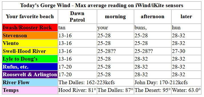
Tuesday’s Dawn Patrol didn’t really cooperate despite solid gradients: 30.07/29.94/29.88 (0.14/0.06). Gradients that strong this early combined with a forecast of 95F in the desert sets us up for a solid day. By mid-morning, we should have 26-29mph from Stevenson to Arlington. We’re currently waiting on low clouds that are supposed to push into the metro area and western Gorge – satellite imagery shows them around Kelso, slowly meandering south. If they don’t make it to the metro area, wind will be less than anticipated.
Early wind was in the 13-16mph range from Stevenson to Rowena (21mh at Viento) with 17-20mph from Avery to Threemile. If those clouds do what they’re supposed to, mid-morning wind will rise to 25-28mph from Stevenson to Arlington. If the clouds don’t join in, the zone from Swell to Hood River will under-perform. Another note: the wind will likley spike for a bit at the Hatch, drop, and then return later this afternoon due to the atmospheric shenanigans.
Afternoon wind rises to 28-32mph all the way from Stevenson to Threemile as offshore high pressure combines with the desert heat low and cooler, more stable air west of Hood River. In the evening, the wind continues, and models suggest the Hatch may really turn on late. Working folks: the wind will wait for you today! Get the Executive Session! Visitors: the Swell sensor (and forecast) reads low compared to other sensors; in other words, 24mph at Swell is not equal to 24mph at Rufus; it’s more like 31mph at Rufus/Arlington. This forecast predicts iWindsurf/iKitesurf sensor readings. River flow over the last 24 hours was 162-223kcfs (170-212 at Rufus), river temp is 63.0F, and high temps forecast is 81F in Hood River and 90+ in the desert.
RIVER FLOW FOR SITES BETWEEN AVERY (EAST OF THE DALLES) AND RUFUS: CLICK HERE FOR JOHN DAY DAM FLOW.
RIVER FLOW FOR SITES BETWEEN STEVENSON AND DOUG’S BEACH (WEST OF THE DALLES): CLICK HERE FOR THE DALLES DAM FLOW

LONGER-TERM gorge wind forecast
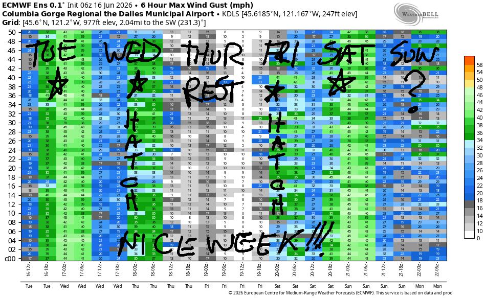
Low clouds coalesce in the metro area Wednesday morning. Desert: clear. Atmospheric shenanigans: way less impactful than on Tuesday. Dawn Patrol looks like 24-27mph from Viento to Hood River, perhaps Mosier too. Stevenson likely starts cloudy with 10-13mph, and the Rowena area starts at 13-16mph. The Corridor wins on Wednesday with 24-27mph all day. Stevenson joins when its clouds burn off. The Rowena zone joins at 24-27mph in the afternoon. Rufus eventually climbs to 17-20mph. High temps: 80F in Hood River and upper 80s east of The Dalles.
High pressure swaddles the land on Thursday and turns the wind light and variable. We might eventually see 11-14mph from Stevenson to Swell in the evening, just enough to cool us off a bit. High temps will be right around 90 degrees.
Cooler air approaches the coast on Friday and gives us low to mid 20s. Focus: Corridor. Saturday brings a stronger marine push and The Cooldown You Were Looking For. As of this morning, models suggest a very big day at the hatch with a solid day in the desert. Fingers crossed! Agreement falls apart on Sunday, but westerlies at 17-20mph or more are likely to continue. Let’s leave it there for today. Hopefully you can get out on the water! See you on the Nch’i Wana soon!

Was that helpful? I knew it was! Guess what? All of this crucial work – from your personal wind and snow reports to the invaluable TATAS updates – is made possible by my relentless efforts. Maintaining this labor of love isn’t easy. Each daily forecast takes hours. Website hosting, weather model access, and back-end admin work takes time and money. That’s where you come in.
YOUR CONTRIBUTION MAKES A DIFFERENCE
- SUPPORT ACCURATE, HYPER-LOCAL WEATHER FORECASTING
- ENABLE ACCESS FOR ALL, EVEN THOSE WITH LESS MEANS
- SUPPORT A COOL HUMAN WHO WORKS HARD SO YOU CAN PLAY
Take a moment to click one of the buttons below. Donate $19.99 or more (how much does this forecast enhance your life?) and get the email in your inbox. Whether it’s a renewing subscription (auto-renew) or a one-time donation, every contribution makes a real difference. Help me keep this labor of love alive, so we can all continue playing, commuting, and living in the Gorge with peace of mind and the best weather forecasts possible. Thank you!


Hood River, Oregon 97031


JONES BEACH, SAUVIE ISLAND, & COAST FORECAST
Wind northerly unless otherwise indicated. For coast, it’s North/Central/South with the “central” at approximately Florence. Swell forecast from NWS for central coast. Jones: westerly unless otherwise stated. Sauvie Island: northerly unless otherwise stated.
Coast Tuesday: 15-20/20-25/30-35, W swell 3′ at 9 seconds. Wednesday: 20-25/25-30/35-40, SW 3′ @ 19. Thursday: 25/20-25/25-30, SW 3′ @ 17. Jones Tuesday: 18-21. Wednesday: 17-20. Thursday: 14-17. Sauvie Island Tuesday: 13-16. Wednesday: 14-17. Thursday: 16.19.
BARE BONES HOOD RIVER WEATHER FORECAST
Mostly clear early. Maybe a few low clouds. Sunny later. Temps start in the upper 60s (RECORD HIGH LOW) and climb to the low 80s. Strong to very strong westerlies. No rainbows. Wednesday will be partly cloudy then clear. Temps start in the low 50s and rise to 80. Strong westerlies. No rainbows. Thursday will be partly high overcast. Temps start in the mid 50s and rise to the upper 80s. Light/variable wind. No rainbows.
TEMIRA’S AWESOME TRAVEL ADVISORY SERVICE
HYPERLOCAL WEATHER FORECAST FOR THE COLUMBIA GORGE
THE DALLES, HOOD RIVER, WHITE SALMON, TROUT LAKE, STEVENSON, CASCADE LOCKS, PARKDALE, ODELL, HUSUM, BZ, MILL A, WILLARD, GOLDENDALE, RUFUS, ARLINGTON, boardman

Good morning, neighbors! All’s quiet in the Gorge to start this morning, but the excitement climbs this afternoon with the addition of strong west wind. DO NOT BURN TODAY. Please secure your trailer chains. Don’t mow or weed whack with a metal blade. Any fires that start today will explode due to the wind. Many counties have burn bans in effect, and there’s a Red Flag Warning (extreme fire danger) posted for much of the Gorge today. There’s no sign of rain in the future to give us relief from the fire danger. While lack of rain is good news for cherry farmers, it means we’re in for a long summer of fire prevention. In the shorter term… generally speaking, temps remain quite warm, 80+ degrees, for the extended forecast period.
Glenwood, friends around the world, and today’s Gorge weather forecast
Today, thank goodness, will be much cooler than yesterday despite the record-warm start. Temps were generally running 60+, although a few areas started the day cooler: Dufur was around 50F, and Glenwood was 48F. Trout Lake started the day super-awesome at SIX-SEVEN degrees. A wiggle in the jet stream moves into BC today bringing cooler conditions compared to Monday. We’ll max out around 80 near Hood River, 87F in The Dalles, and 95F in the desert, which isn’t any cooler than yesterday. In response to the temp gradient from west to east, west wind skyrockets: Afternoon wind rises to 25-35mph all the way from Stevenson to Boardman. Really, seriously, take care with sparks and flames and coals and other fire-related stuff today.
Tehran, Iran: 93, sunny, 10% humidity
Havana, Cuba: 82, sunny, 79% humidity
Muscat, Oman: 96, sunny, 49% humidity
Caracas, Venezuela: 72, cloudy, 87% humidity
Nuuk, Greenland: 46, sunny, 79% humidity
Gaza City: 82, sunny, 59% humidity
Wednesday Gorge weather forecast
Clouds push inland to Viento (ish) early Wednesday morning, and cooler air flows into the Gorge. We start the day in the 50s most places. Right off the bat, west wind will be 25mph between Viento and Mosier. It eventually picks up to 25-30mph between Stevenson and The Dalles with 15-20mph near Biggs and Rufus. Highs will be 80F west of Mosier, in the mid 80s between Mosier and The Dalles, and near 90 out in the desert.
Thursday Gorge weather forecast
High pressure returns on Thursday and takes temps to the 90-93 range (too hot for TATAS) all across the Gorge. At least it’ll be cool enough in the morning, 50-55F, to cool off our homes. Wind will be light and variable Thursday becoming westerly at 10-15mph west of Mosier in the evening. Quick, do all the light-wind stuff before the wind roars back on Juneteenth!
Extended Gorge weather forecast
Slightly cooler, windier weather is forecast Juneteenth (Friday) and Saturday. Models show more uncertainty starting Sunday. I’ll leave you there for now. Community safety PSA: if you see !CE activity or suspect you see !CE vehicles, please call PIRC: 888-622-1510. Go ahead and put that in your phone now. Help keep our community safe and protected. Safety isn’t just about weather. Safe travels. -TATAS
HEY! DON’T STOP READING! Is this community-focused forecast helpful to you? It sure is! It takes me a couple hours a day to write. Please join your friends and neighbors in contributing to keep it going. Venmo: @thegorgeismygym PayPal: twomirrors@gmail.com USPS: Temira / PO Box 841 / Hood River, Oregon 97031 You can test out the forecast subscription for a few days for free by signing up below. Easy! Do it!
MT HOOD SNOW FORECAST

QR codes and links for end-of-season tips – thank you!!!
Cash/check: Temira – PO BOX 841 – Hood River, Oregon 97031


Leave a Reply