
Thank you for using this forecast. Like it? Find it useful? Support it (and me!) by sending some cash my way. Why? It takes me an hour or two each morning to produce this, and it makes your life better, safer, and more fun. That’s worth something! You can get the email version sent to you. Not $99 a year. Nope. Not $49. Just $12.34 or more gets you a subscription. Click below to give financial support. Thank you!!
Credit card payments click here – – – – – – – – – Click here to use your PayPal
Venmo: @theGorgeismyGym
Snail Mail: PO Box 841, Hood River, Oregon 97031
(note: I am not a non-profit entity. The only way to accept credit cards with a user-defined amount is to use the ‘donate’ button. Thanks for understanding!)
Auto-renewing subscription. New! Awesome!
The Forecast
CoronaChat
I worry that this selfishness will result in a longer period of lockdown. I worry that people will get hurt and end up using valuable resources. I worry that the more people think only of themselves, the more my friends in the medical profession will be put at risk. I worry that my friends will die.
I’m guessing that everyone reading this loves the outdoors. I know I do. Accessing the mountains and the trails and the water brings joy to my life. But there’s also joy that comes from outside. Fighting against reality, which in this case means very limited access to outdoor recreation, only makes us feel worse.
Seeking out other sources of joy (meditation, prayer, relationships, art, cooking, learning) gives us the freedom to make better choices. And seeing the ways we’re still connected to Nature can give some relief. Please, I’m begging you. Stay home. Save lives. Your choices could put your friends and community at risk. Practice patience, and our beloved outdoor recreation will return sooner rather than later.
| 4a-8a | 8a-12p | 12p-4p | 4p-8p | 8p-4a | |
|---|---|---|---|---|---|
| Tuesday 1500′->2000′->1000′ |
 |
|
|
 |
|
| Wednesday 1000′->2000′->500′ |
|
|
 |
 |
 |
| Thursday 500′->2000′->500′ |
 |
|
|
|
|
Mt. Hood Weather Forecast
Significant snowpack increases over the last 48 hours or so are setting us up for a better water year than expected this summer. It’s also making for treacherous conditions on the passes – I don’t even have to look at Tripcheck to tell you that chains are required. Snowy driving conditions continue over the next few days as low snow levels keep the snowpack climbing. Now, some of you will be tempted to go out backcountry skiing. Take a look at this sobering article about a recent BC rescue and consider carefully if you want to put others at risk. As for the forecast, light snow continues today. The snow level will be 1500-200′ in the morning, 2000′ in the afternoon, and 1000′ overnight. About 0.5” water value (WV) falls during the day, for 4-6” of new. Another 0.1” falls overnight, for another inch. Wind will be WNW 25-30 in the morning, W 30 in the afternoon, and WNW 15 overnight.Snowfall continues Wednesday morning before tapering off in the afternoon. There is a chance of thunder and hail in the afternoon before the sky clears overnight. The snow level will be 1000′ early, 2000′ in the afternoon, and 500′ under clear sky overnight. About 0.3” WV falls during the day, for 3-4” of snow. Just a trace falls in the evening. Wind will be WNW 15 in the morning, NW 10-15 in the afternoon, and WNW 15-20 overnight.
Thursday looks clear in the morning with atmospheric instability in the afternoon for mid-level clouds and a chance of thunder. The freezing level will be 500′ early, 2000′ in the afternoon, and 0′-500′ overnight. A trace of snow or hail may fall in the afternoon. Other than that – dry weather all day. Wind: WN W 15-20 early, NW 15-20 ion the afternoon, and W 10 overnight.
Friday looks mostly dry and clear with a moderate likelihood of instability and afternoon clouds. Snowfall returns on Saturday afternoon and ramps up over the weekend and into the early part of next week (unless something changes!). Yes, it’s tempting. Please don’t go up there – the National Forests are closed. You’d be breaking the law and putting others at risk. There will be another ski season!
Gorge Wind Forecast
First, a public service announcement. All Oregon and Washington State Parks are closed at this time. All Port of Hood River waterfront access is closed at this time. The Army Corps has closed all parks. They have also closed boat ramps. Swell City is also closed. This is an order to obey. It’s not one to sneak around and find a way to get on the river instead. That’s especially for you locals – set a good example so you don’t have folks coming down here from Covid-19 epicenters to play on the river and shop at our stores.For Tuesday, the morning starts with light west wind. Afternoon westerlies pick up to 10-13mph in the west and gusty 25-29 from The Dalles to Boardman. Wednesday starts light and variable. Afternoon wind picks up to W 7-11 from Stevenson to Avery with light wind in the eastern Gorge. Thursday starts with W 10-13 and picks up to 19-22 from Stevenson to Avery. The eastern Gorge ends up with light and variable wind.
COAST, JONES, SAUVIE’S: Detailed forecast is on winter break.
Hood River Weather Forecast
Nice day to stay inside! Rain falls all morning, becoming lighter and showery this afternoon. Temps will be in the upper 30’s early and upper 40’s later. Light wind early. Moderate to strong in the afternoon. 99% chance of rainbows. Wednesday looks rainy in the morning and showery in the afternoon with a chance of thunder and hail. Temps will be in the mid 30’s early and upper 40’s later. Light and variable wind early. Light wind later. 99% chance of rainbows. Thursday looks cloudy in the morning, clear midday, and partly cloudy with a chance of thunder and hail in the afternoon. Temps will be in the mid 30’s early and upper 40’s later. Light west wind early. Moderate later. 48% chance of rainbows. Looking for a complete Columbia Gorge forecast? Looking for more humor in your weather? Obscenities? You’re looking for my TATAS: Temira’s Awesome Travel Advisory Service on Facebook.Cycling
All trails and sno-parks in the Mt. Hood National Forest, Gifford Pinchot National Forest, and Columbia Gorge National Scenic Area are closed. While Post Canyon trails may be open as of this morning, you are not allowed to park at the bottom of Post or anywhere else in the trail system. You must ride there from somewhere else. Given the amount of rain we’ve had the trails will be too muddy to ride anyway. So, skip it! The Mosier Twin Tunnels trail is closed. If you want to ride a bike, please do so on the road where 1) social distancing is possible and 2) you are less likely to get injured and put a strain on the medical system.Upcoming Events – this section is on vacation due to Covid-19
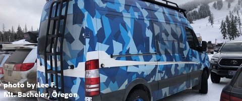
White Sprinter Van of the Week!
Click here for the White Sprinter Van map of the world!!!
Random Morning Thoughts – on break
Click here for the full events calendar.
Have an awesome day!
Temira