

MT HOOD SNOW FORECAST

QR codes and links for end-of-season tips – thank you!!!
Cash/check: Temira – PO BOX 841 – Hood River, Oregon 97031


Hey skiers and snowboarders! It’s been a rough season, and here with are with a pow day in mid-April. Timberline picked up 21” of fresh show. Meadows telemetry says 18”, and they have dropped uphill traffic restrictions. Teacup took the snowmobile out and did some snowmobile grooming yesterday – they plan more today. I guess I shouldn’t have taken off my snow tires! Chains or traction tires are required as of the time of this forecast on 26 and 35.
Tomorrow, Friday, will be the last snow forecast for the season (unless something unexpected happens). If you’ve found this useful, especially if you’ve been reading on the website, please consider leaving an end-of-season tip!
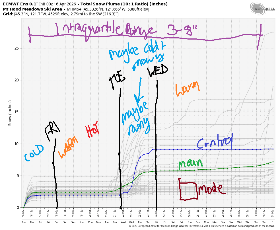
Short term Mt Hood snow forecast
Weather today will be sunny, and the April sun is strong, so get it as early as you can. The free air freezing level rises from 1000′ this morning to 2500′ this afternoon and 1000′ after midnight. Temps max out in the upper 20s at 5000′. Even so, the April sun will warm the snow and make it increasingly heavy. Wind today will be NW 25-30 in the morning, WNW 20-25 in the afternoon, and NW 20-25 after midnight. Snow surface: pow and packed pow warming to mashed potatoes.
Friday stays clear and sunny for most of the day. High clouds arrive in the afternoon and stick around. The free air freezing level starts around 1000′, rises to 5500′ in the afternoon, and reaches 7000′ after midnight. Temps max out around 40 degrees. Wind will be NW 20-25 in the morning, light westerly in the afternoon, and SSW 5-15 overnight. Snow surface is likely to be somewhere in the hardpack zone on the groom and sun crust off the groom.
Extended Mt Hood Snow Forecast
Sunshine continues Saturday morning, but high clouds take over in the afternoon. The free air freezing level rises from 7000′ to 9000′ with temps pushing all the way to 50 degrees. Wind will be 5-15mph out of the S or SW. Sunday looks similar – warm (low 50s) with light south wind.
Uncertainty skyrockets on Monday and continues into the deep future. We’re likely to see some precipitation in the middle of next week, but it’s likely to be rain. Beyond next Wednesday, models indicate warm weather. So… be glad we got this big mid-April snowstorms!
Was that helpful? I knew it was! Guess what? All of this crucial work – from your personal wind and snow reports to the invaluable TATAS updates – is made possible by my relentless efforts. Maintaining this labor of love isn’t easy. Each daily forecast takes hours. Website hosting, weather model access, and back-end admin work takes time and money. That’s where you come in.
YOUR CONTRIBUTION MAKES A DIFFERENCE
- SUPPORT ACCURATE, HYPER-LOCAL WEATHER FORECASTING
- ENABLE ACCESS FOR ALL, EVEN THOSE WITH LESS MEANS
- SUPPORT A COOL HUMAN WHO WORKS HARD SO YOU CAN PLAY
Take a moment to click one of the buttons below. Donate $19.99 or more (how much does this forecast enhance your life?) and get the email in your inbox. Whether it’s a renewing subscription (auto-renew) or a one-time donation, every contribution makes a real difference. Help me keep this labor of love alive, so we can all continue playing, commuting, and living in the Gorge with peace of mind and the best weather forecasts possible. Thank you!


Hood River, Oregon 97031


GORGE WIND FORECAST
If you’re still seeing yesterday’s and it’s after 9am, try opening this in an incognito window
SHORT-TERM gorge wind forecast
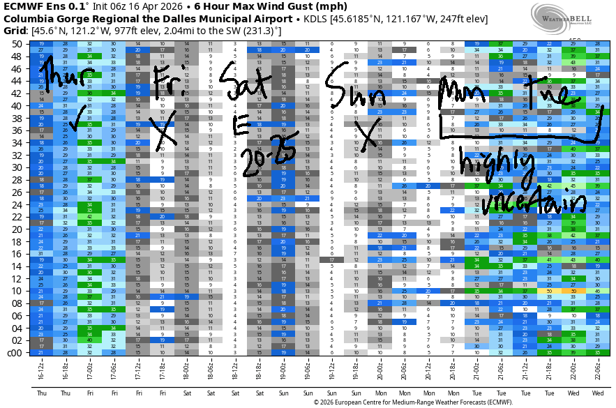
Hi friends! Looks like yesterday was another good day out at Rufus and Arlington. Work is getting in the way of me joining in! But I think I can pull it off today, and so should you! After today, we have a four-day stretch of “not much” – the next wind of any sort is on Saturday when easterlies rise to the marginal range: 20-25mph.
Thursday started with pressures of 30.18/30.12/30.03 for gradients of 0.06/0.09. This suggests Doug’s-Rufus for the sure thing. That said… models suggest clouds will dissipate in Hood River and allow wind in the Corridor (Viento to Hood River) too. Give it a couple hours to warm up. By mid-morning, we’ll have 18-21mph from Viento all the way to Arlington. A few hours of 20-23mph are likely from Viento to Hood River (and eventually Stevenson) into early afternoon.
During that same time period, the Mosier-Rufus stretch begins building and eventually lands at 29-33mph. Arlington makes it to 22-25mph this afternoon – wind speeds drop east of Rufus as clouds dissipate in the west. River flow over the last 24 hours was 189-218kcfs (209-217 at Rufus), river temp is 50.7F, and high temp forecast is 54F in Hood River and 61F out in the desert with mostly sunny sky.
RIVER FLOW FOR SITES BETWEEN AVERY (EAST OF THE DALLES) AND RUFUS: CLICK HERE FOR JOHN DAY DAM FLOW.
RIVER FLOW FOR SITES BETWEEN STEVENSON AND DOUG’S BEACH (WEST OF THE DALLES): CLICK HERE FOR THE DALLES DAM FLOW

LONGER-TERM gorge wind forecast
Friday starts with light westerlies, perhaps 7-10mph. By midday, the wind goes calm. Afternoon sees a rebound to 10mph near Stevenson, and only near Stevenson. High temp: 62F and partly high cloudy.
On Saturday, high pressure builds inland and a low spins well off the coast. This results in easterlies. Early in the day, you’ll find 25mph at Iwash (Rooster) Rock and 20mph at Stevenson. By afternoon, Iwash turns light/variable and Stevenson drops below 15mph. High temp: 68F and high overcast. Sunday currently looks light and variable. Uncertainty increases on Monday, so I’ll leave ya here for now. Hope to see you on the Nch’i Wana today!

BARE BONES HOOD RIVER WEATHER FORECAST
Partly cloudy sky this morning and mostly sunny later. Temps start in the upper 30s and end in the mid 50s. Moderately strong westerlies. No rainbows. Friday will be partly high cloudy then high cloudy. Temps start in the mid 30s and rise to the low 60s. Light west wind early. Calm later. No rainbows. Saturday will be high cloudy. Temps start in the upper 30s and rise to the upper 60s. Light easterlies. No rainbows.
TEMIRA’S AWESOME TRAVEL ADVISORY SERVICE
HYPERLOCAL WEATHER FORECAST FOR THE COLUMBIA GORGE
THE DALLES, HOOD RIVER, WHITE SALMON, TROUT LAKE, STEVENSON, CASCADE LOCKS, PARKDALE, ODELL, HUSUM, BZ, MILL A, WILLARD, GOLDENDALE, RUFUS, ARLINGTON, boardman
Good morning, neighbors! Many of you picked up a wee bit of snow yesterday – I can see snow on Underwood Mountain, and I heard tales of snow in Parkdale, High Prairie, and Trout Lake. Snow is done falling, but we’re not out of the woods with frost/freeze conditions until Saturday or Sunday. General forecast for the next ten days is cool until Saturday, dry until the middle of next week, and warm towards the end of next week.
Oops I lied about snow being done – I see light snowfall on the tippy top of Underwood. Speaking of snow, Timberline picked up 21” in this last storm. I haven’t seen Mt. Defiance this morning, but I’m betting it’s no longer snow-free. Hopefully you didn’t plant your tomatoes!
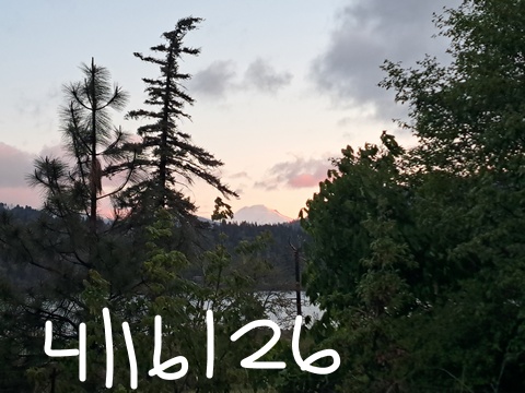
Glenwood this morning
It’s not snowing in Glenwood this morning because it’s clear. And because it’s clear, the temp has dropped to 25F, which doesn’t kill ticks, btw. Tick populations don’t drop because of cold. They drop in response to host (mouse, deer, snipe) populations dropping.
Today’s Gorge weather forecast
Today’s weather is unlikely to result in the reduction of tick populations, but maybe my friend Dick’s cats will reduce the gopher population some more and help with the ticks! This morning’s temps started in the 28-33 range in Parkdale, mid 30s in Mosier, and 29-34F in The Dalles. Goldendale: 28F, Centerville: 30F, Trout Lake: 32F. Afternoon temps only rise to 54F (west, partly cloudy), 57F (The Dalles), and 61F (The Desert). Clouds decrease during the day, and most of us end up mostly sunny. We’ll have west wind today: 20-25mph west of Mosier and 25-30mph from Mosier to Arlington.
Friday’s Gorge weather forecast
Overnight, the wind drops below 10mph all through the Gorge, the sky mostly clears, and dewpoints fall to 18-29F. At 850mb (~5000′), temps will be -3C. Widespread frost and sub-freezing temps are likely. Parkdale, Trout Lake, The Dalles: 27-30F. Mosier: 29-32F. Glenwood, Centerville, Goldendale: 25-28F. Odell: 30-33F. For the rest of the day… high clouds slide in, temps rise to the low 60s in the lowlands, and the wind goes dead calm.
Saturday’s Gorge weather forecast
On Saturday, we’ll have high clouds and filtered sun all day long. Morning temps are going to be warmer, but there’s still some chance of frost due to low dewpoints, east wind, and at least some radiational cooling overnight. Current guess for Parkdale is 32-35F. But that might change. Afternoon highs on Saturday will be 68-72F, warmest east of The Dalles. Wind will turn easterly. At Iwash (pen*s) Rock, you’ll find 25mph in the morning and calm wind in the afternoon. Stevenson: 20mph fading to 10mph. Rest of the Gorge: light easterly.
Extended Gorge weather forecast
High clouds and warmer temps are forecast on Sunday along with light and variable wind. Temps range from 69-76F down low with 50 degrees on the ski slopes and hiking trails at 5000′. Monday looks similar. Beyond that, uncertainty increases. It does look like we’ll see at least a little precipitation in the middle part of next week, but details are not clear. Safe travels. -TATAS
HEY! DON’T STOP READING! Is this community-focused forecast helpful to you? It sure is! It takes me a couple hours a day to write. Please join your friends and neighbors in contributing to keep it going. Venmo: @thegorgeismygym PayPal: twomirrors@gmail.com USPS: Temira / PO Box 841 / Hood River, Oregon 97031 You can test out the forecast subscription for a few days for free by signing up below. Easy! Do it!
JONES BEACH, SAUVIE ISLAND, & COAST FORECAST
ON WINTER VACATION UNLESS DESPERATELY NEEDED.
