

MT HOOD SNOW FORECAST

QR codes and links for end-of-season tips – thank you!!!
Cash/check: Temira – PO BOX 841 – Hood River, Oregon 97031


Hey skiers and snowboarders! Thank you so much for using this forecast all winter. I’m betting all of us wished for more snow. Hopefully this forecast helped you make the most of the snow we received. If it was helpful, please consider making an end-of-season tip to support me and all the work I put in to making your life more fun!
If you don’t use electronic payments, you can send cash or check to: Temira / PO Box 841 / Hood River, Oregon 97031
THANK YOU FOR YOUR SUPPORT!!! HAVE A GREAT SUMMER!!!
Sign up to try out the year-round forecast for wind, snow, and everything else!
GORGE WIND FORECAST
If you’re still seeing yesterday’s and it’s after 9am, try opening this in an incognito window
SHORT-TERM gorge wind forecast
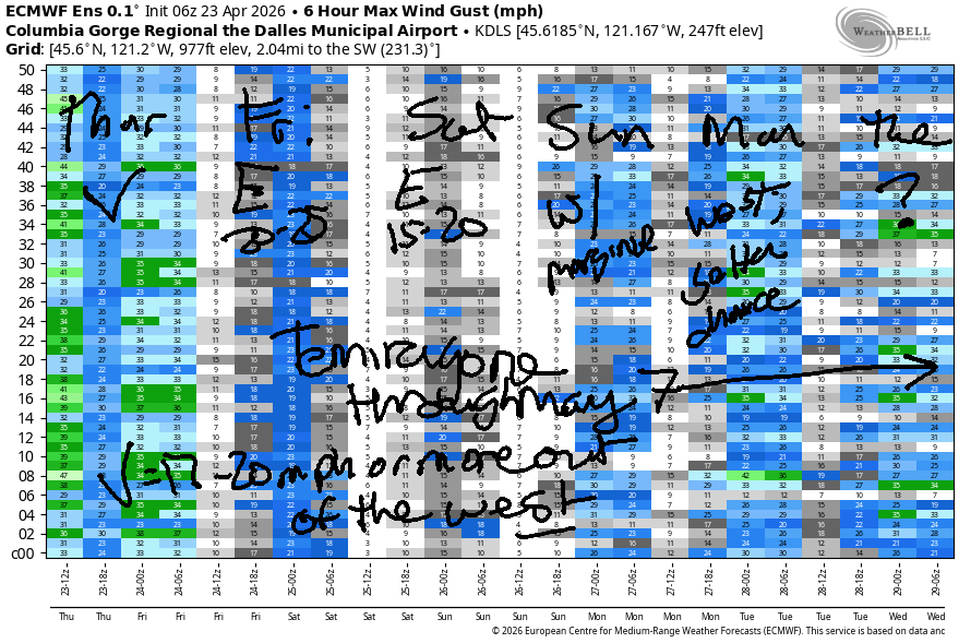
Hi friends! Sounds like the Blalock-Arlington stretch delivered the nukage late afternoon yesterday. Other locations, as expected, were impacted at various levels by the rain’s dampening effect. Even so, the Hatch had good, high-energy swell midday into the afternoon, and I’m sure some of you found fun other places. We’ll have westerlies today, easterlies Friday and Saturday, and a likely return to west wind Sunday. I’ll be on a silent retreat starting Friday, 4/24 through Thursday, 5/7. I shall see you again for a forecast on the 8th.
Thursday started with pressures of 30.23/30.15/30.06 for gradients of 0.08 and 0.09. While those numbers suggest you should head east, building high pressure suggests you’ll want to stay closer to Hood River. Early wind was right around 20mph east of Lyle to Threemile and in the 10-13mph range between Stevenson and Mosier. Exception: Viento at 29mph. There’s a decent chance of a period of 22-25mph from Lyle to Arlington early this morning before the wind drops to the teens or less in the desert this afternoon.
As the clouds burn back this morning, we’ll see the zone from Swell to Mosier build to 18-21mph with a slight chance of 20-23mph. Afternoon is a bit trickier – models suggest the wind will drop off to 11-14mph before rebuilding to gusty 19-22mph from Stevenson to Doug’s after 2pm as the desert warms. If the west-side clouds are more persistent than expected, the wind will exceed expectations, especially given very strong offshore high pressure. Fingers crossed. Either way, there should be a period of strong-enough wind to get some of you on the water. River flow over the last 24 hours was 193-230kcfs, river temp is 51.1F, and high temp forecast is 63F with decreasing clouds.
RIVER FLOW FOR SITES BETWEEN AVERY (EAST OF THE DALLES) AND RUFUS: CLICK HERE FOR JOHN DAY DAM FLOW.
RIVER FLOW FOR SITES BETWEEN STEVENSON AND DOUG’S BEACH (WEST OF THE DALLES): CLICK HERE FOR THE DALLES DAM FLOW

LONGER-TERM gorge wind forecast
High pressure builds inland overnight into Friday morning and turns the wind easterly. The day starts with E 10-15mph near The Dalles and light east wind elsewhere. By mid-morning, Stevenson and Iwash (Rooster) Rock rise to 20-25mph for a couple hours. As usual, we’ll see an afternoon fade. Stevenson and Iwash finish the day at 15mph, and areas to the east finish at 10mph. High temp: 63F and mostly clear.
Saturday brings another round of easterlies: 15-20mph in the morning at Stevenson and Iwash. Afternoon wind drops below 10mph all through the Gorge. Sunday is likely to start calm and turn westerly in the afternoon. As of this morning, the forecast suggests 15-18mph or so focused near the Hatch. Uncertainty increases as we look at the start of next week, but westerlies of some sort are likely Monday and Tuesday. Have a great couple of weeks, everyone. I’ll be back for you, refreshed and happy, on the 8th of May!

Was that helpful? I knew it was! Guess what? All of this crucial work – from your personal wind and snow reports to the invaluable TATAS updates – is made possible by my relentless efforts. Maintaining this labor of love isn’t easy. Each daily forecast takes hours. Website hosting, weather model access, and back-end admin work takes time and money. That’s where you come in.
YOUR CONTRIBUTION MAKES A DIFFERENCE
- SUPPORT ACCURATE, HYPER-LOCAL WEATHER FORECASTING
- ENABLE ACCESS FOR ALL, EVEN THOSE WITH LESS MEANS
- SUPPORT A COOL HUMAN WHO WORKS HARD SO YOU CAN PLAY
Take a moment to click one of the buttons below. Donate $19.99 or more (how much does this forecast enhance your life?) and get the email in your inbox. Whether it’s a renewing subscription (auto-renew) or a one-time donation, every contribution makes a real difference. Help me keep this labor of love alive, so we can all continue playing, commuting, and living in the Gorge with peace of mind and the best weather forecasts possible. Thank you!


Hood River, Oregon 97031


BARE BONES HOOD RIVER WEATHER FORECAST
Partly cloudy this morning and sunny later. Temps start in the upper 40s and rise to the low 60s. Moderate westerlies. No rainbows. Friday will be mostly clear then partly cloudy. Temps start in the upper 30s and rise tot he low 60s. Moderate easterlies. No rainbows. Saturday will be clear then partly cloudy. Temps start in the upper 30s and rise to the mid 60s. Light easterlies. No rainbows.
TEMIRA’S AWESOME TRAVEL ADVISORY SERVICE
HYPERLOCAL WEATHER FORECAST FOR THE COLUMBIA GORGE
THE DALLES, HOOD RIVER, WHITE SALMON, TROUT LAKE, STEVENSON, CASCADE LOCKS, PARKDALE, ODELL, HUSUM, BZ, MILL A, WILLARD, GOLDENDALE, RUFUS, ARLINGTON, boardman
Good morning, neighbors! Yesterday sure was a fun one – lots of rain and lots of wind. For a few hours in the evening, the Arlington Triangle boasted average wind speeds of 35-40mph. Boardheads were happy. Tumbleweeds were happy. That should make all of us happy! Nothing particularly exciting is forecast over the next several days. Instead, we’ll have sunshine, pop-up clouds in the afternoon, and frost chances Friday, Saturday, and Sunday mornings for select folks. Starting tomorrow, I’ll be on a silent retreat for two weeks. My housesitter, being on vacation, has declined to take over the forecast. I shall see you when I return!
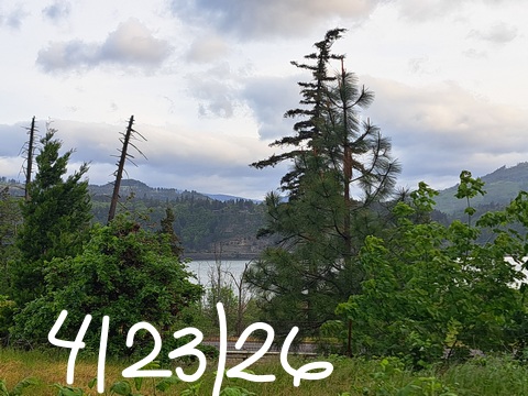
Glenwood this morning
Looking around the Gorge this morning, we have Glenwood at 40 degrees. Almost everyone else is above freezing. Exception: Clear Creek Road in Parkdale is 31 degrees this morning, a sign of much cooler air at elevation. As a matter of fact, it was so cool aloft that Timberline picked up about 7” of snow yesterday!
No snow is forecast today here in the Gorge (duh). Also not seen this morning: !CE, thankfully!
Today’s Gorge weather forecast
To start Thursday, we have clouds to the west and sun to the east with temps in the 40-50F range. Afternoon brings clear sky and 63 degrees (west) to 66 degrees (The Dalles) to 70 degrees (Fred Meyer) to 1,000,000 degrees (Hell). West wind will be 15-25mph in the morning and 15-20mph this afternoon all the way from Stevenson out into Arlington’s Triangle.
Friday’s Gorge weather forecast
We’ll hold on to clear sky into Friday morning. Thanks to east wind, dewpoints fall to 22-33F, with those coldest dewpoints on the slopes of Mt. Hood. At 850mb (~5000), temps will be between 0C and +3C. This puts Parkdale, Trout Lake, Glenwood, and Centerville in the 32-36F range. By afternoon, temps rise to 63F all through the Gorge with slightly cooler temps way out east near Hermiston. Little Fluffy Clouds pop up in the afternoon, everyone drops acid or MDMA, and everyone dances in the streets in a peaceful demonstration of the power of psychedelics for resistance against fascism. Or something like that.
Friday’s wind will be E 10-15mph near The Dalles to start with widespread E 10-15mph from midday on. Stevenson and Iwash (pen*s) Rock max out at 20-25mph midday before fading to 10-15mph in an attempt to be the same as all the other locations. Hint: if you are trying to be the same as everyone else, you will fail. Try being you instead. You are more awesome than you think.
Saturday’s Gorge weather forecast
On Saturday morning, frost chances are higher thanks to dewpoints in the 11-25F range. Remember that the driest air is up in the mountains, but it’s helpful to name it, kinda like your emotions: it’s helpful to name them too, at least silently to yourself and sometimes out loud! At 850mb, temps will be +1C. 30-34F seems likely for Parkdale, Centerville, Goldendale, Dufur, and the east side of The Dalles. Glenwood: 24-28F. Thanks to copious sunshine and another round of pop-up popcorn clouds, Saturday finishes right around 64-65F. Wind will be E 15-20mph near the usual spots (Cock Rock, Cascade Locks) in the morning with all areas fading to under 10mph in the afternoon. Regarding the frost… my garden is on the Heights in Hood River, and I’m concerned enough that I’m not planting tomatoes before I leave on my retreat. You should hold off too!
Sunday’s Gorge weather forecast
Another round of clear sky, low dewpoints, and cool air (+3C) aloft is forecast on Sunday for a lesser chance of frost. Still, 32-36F seems possible in Parkdale and other cool spots. Afternoon temps rise to … you got it… SIX-SEVEN (fuck yeah!) degrees pretty much everywhere. Calm wind in the morning gives way to west wind at 15-20mph west of The Dalles in the afternoon.
Extended Gorge weather forecast
Looking at the extended forecast (extended being however long I decide to make it with the start date also determined randomly by me), we see a slight chance of drizzle in the Monday-Tuesday window. It’s worth noting that temps aloft will remain relatively cool with slight frost chances through Tuesday morning. After that, uncertainty increases, but a general trend of “warmer and mostly dry” is in the cards through, well, the end of my retreat. I think that’s just peachy both for those of you staying in the Gorge and me in Washington happily exploring my own mind in service of my peace and kindness towards all beings. May y’all be happy, safe, healthy, and free from stress. See ya on the flip side! Safe travels. -TATAS
HEY! DON’T STOP READING! Is this community-focused forecast helpful to you? It sure is! It takes me a couple hours a day to write. Please join your friends and neighbors in contributing to keep it going. Venmo: @thegorgeismygym PayPal: twomirrors@gmail.com USPS: Temira / PO Box 841 / Hood River, Oregon 97031 You can test out the forecast subscription for a few days for free by signing up below. Easy! Do it!
JONES BEACH, SAUVIE ISLAND, & COAST FORECAST
ON WINTER VACATION UNLESS DESPERATELY NEEDED.
