

GORGE WIND FORECAST
If you’re still seeing yesterday’s and it’s after 9am, try opening this in an incognito window
SHORT-TERM gorge wind forecast
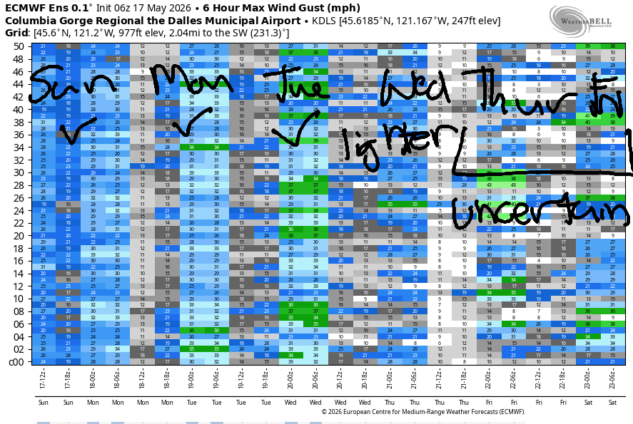
Hi friends! The rest day you’ve been looking for is scheduled today, although a few of you might take advantage of easterlies midday near Stevenson and Viento. Westerlies return on Friday and ramp up on Saturday. Reality may beat the models on Sunday, but an approaching weather system in the afternoon is likely to reduce wind quality and reliability. For Memorial Day, we’re looking at a strong cold front moving through. Generally, this gives us gusty, strong westerlies in the eastern Gorge. This system will give us rain on the west side. Beyond that, model uncertainty is high, but there’s some indication of strong wind Tuesday and Wednesday, and westerlies are generally forecast to linger into the extended forecast. Fingers crossed for that!
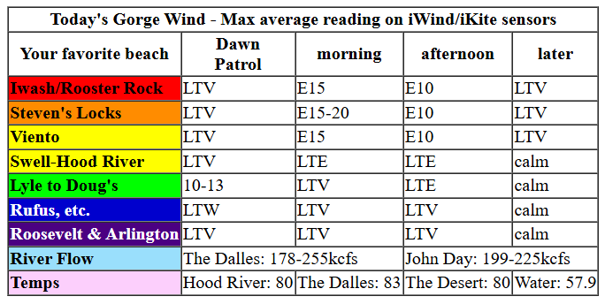
Thursday started off sunny and rather calm with pressures of 30.12/30.09/30.12. Models suggest easterlies will rise to 15mph near Stevenson this morning, perhaps 15-20mph if we get lucky. Iwash (Rooster) Rock rises to 10-15mph for a couple hours. By noon, wind will be on the downward trend to 10mph. It keeps falling into the evening; we’re left with nearly calm conditions or even glassy conditions to finish the day. River flow over the last 24 hours was 178-255kfs (199-225 at Rufus), river temp is 57.9F, and high temp forecast is 80F.
RIVER FLOW FOR SITES BETWEEN AVERY (EAST OF THE DALLES) AND RUFUS: CLICK HERE FOR JOHN DAY DAM FLOW.
RIVER FLOW FOR SITES BETWEEN STEVENSON AND DOUG’S BEACH (WEST OF THE DALLES): CLICK HERE FOR THE DALLES DAM FLOW

LONGER-TERM gorge wind forecast
Clear sky greets us on Friday. The forecast calls for the heat low to shift inland in the afternoon thanks to an approaching trough, and that’ll give us westerlies. The day starts with 10-13mph near Viento and under 10mph everywhere else. We’ll see a slow and steady build into the evening. By midday, westerlies climb to 13-16mph from Stevenson to Mosier. By late afternoon and into the evening, we’ll have 16-19mph from Stevenson to Doug’s with 11-14mph from Avery to Rufus. High temp: 82-86F.
Cool air and marine clouds take over the west side Saturday morning, and the desert will be mostly clear. Exact Dawn Patrol location depends on the extent of the low clouds. For now, let’s call it 25-28mph from Viento to Mosier with 11-14mph in cloudy Stevenson and 15-18mph from Rowena to Rufus for the early session. (I’M ALL JACKED UP FOR THIS!) Westerlies ramp up to 27-31mph from Stevenson to Mosier with 20-23mph near Rowena and 17-20mph near Rufus by late morning. Models (sadly) are calling for clouds to burn off in the metro area. When/if this happens, the Hatch wind will fade. Turn your attention to the Mosier-Rufus stretch for 26-29mph in the afternoon. Stevenson-Viento hang in with 21-24mph, and the Hatch likely drops to gusty 18-22mph. Arlington eventually builds to 20-23mph in the evening. High temp: 79F in Hood River and 89F in the desert.
An approaching weather system on Sunday throws a wrench into the stability machine. Models are all over the place on wind speed for Sunday; we could see upper teens, and we could see mid 20s. Given the significant cross-Cascade temp gradient, I’d guess we’ll see 20mph or more, but it’s likely to be gusty. High temp: 76F in Hood River and 84F in the desert.
A cold front swings through on Monday and brings rain to much of the Gorge in the afternoon. Models are all over the place with the wind. Most likely scenario is a burst of strong west wind ahead of the weather system and a longer-lasting but somewhat lesser period of westerlies after the rain diminishes. Model uncertainty increases on Tuesday and Wednesday, but generally speaking we have offshore high pressure and an onshore temp gradient. Both days are likely to be decent. After Wednesday, uncertainty really increases, so I’ll leave it there for now. Looks like a good stretch of wind, eh? See you on the Nch’i Wana soon!

Was that helpful? I knew it was! Guess what? All of this crucial work – from your personal wind and snow reports to the invaluable TATAS updates – is made possible by my relentless efforts. Maintaining this labor of love isn’t easy. Each daily forecast takes hours. Website hosting, weather model access, and back-end admin work takes time and money. That’s where you come in.
YOUR CONTRIBUTION MAKES A DIFFERENCE
- SUPPORT ACCURATE, HYPER-LOCAL WEATHER FORECASTING
- ENABLE ACCESS FOR ALL, EVEN THOSE WITH LESS MEANS
- SUPPORT A COOL HUMAN WHO WORKS HARD SO YOU CAN PLAY
Take a moment to click one of the buttons below. Donate $19.99 or more (how much does this forecast enhance your life?) and get the email in your inbox. Whether it’s a renewing subscription (auto-renew) or a one-time donation, every contribution makes a real difference. Help me keep this labor of love alive, so we can all continue playing, commuting, and living in the Gorge with peace of mind and the best weather forecasts possible. Thank you!


Hood River, Oregon 97031


JONES BEACH, SAUVIE ISLAND, & COAST FORECAST
Wind northerly unless otherwise indicated. For coast, it’s North/Central/South with the “central” at approximately Florence. Swell forecast from NWS for central coast. Jones: westerly unless otherwise stated. Sauvie Island: northerly unless otherwise stated.
Coast Thursday: 20-25/25/30-35, NW swell 6′ at 11 seconds. Friday: 15-20/20-25/30-35, NW 6′ @ 11. Saturday: 15-20/20-25/25-30, NW 6′ @ 9. Jones Thursday: 14-17. Friday: 23-26. Saturday: 18-22. Sauvie Island Thursday: 11-14. Friday: 13-16. Saturday: 10-13.
BARE BONES HOOD RIVER WEATHER FORECAST
Clear sky this morning with a few mixed clouds later. Temps start in the upper 40s and rise to 80. Light easterlies then calm. No rainbows. Friday will be mostly clear. Temps start in the low 50s and rise to the low 80s. Light westerlies early. Moderate later. No rainbows. Saturday starts partly cloudy then turns clear. Temps start in the low 50s and rise to the mi d70s. Strong westerlies. No rainbows. Next chance of rain: Monday.
TEMIRA’S AWESOME TRAVEL ADVISORY SERVICE
HYPERLOCAL WEATHER FORECAST FOR THE COLUMBIA GORGE
THE DALLES, HOOD RIVER, WHITE SALMON, TROUT LAKE, STEVENSON, CASCADE LOCKS, PARKDALE, ODELL, HUSUM, BZ, MILL A, WILLARD, GOLDENDALE, RUFUS, ARLINGTON, boardman
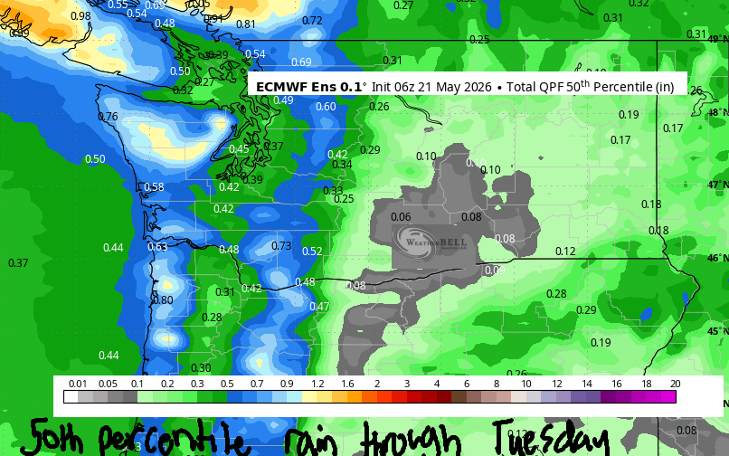
Good morning, neighbors! Not much going on in weather news until Saturday, when strong wind is expected west of Rufus, and Monday, when rain returns to the picture. Along with the rain, we’ll see the snow level drop as low as 4500′ – if the sky is clear enough on Tuesday morning, Dufur and Glenwood could drop near or below freezing. The rest of you – unlikely to need anything other than an extra layer of clothing on you. Plants should be fine. Pants will be fine too, as will the ants and sycophants!
Glenwood and Tehran this morning, and today’s Gorge weather forecast
Looking around the Gorge this morning, we have a lovely, sunny, clear-sky start to the day. Glenwood kicked it off with 38 degrees, but Centerville was the winner with 37F! In Tehran, Iran, the forecast today is for increasingly windy weather with a high of 79 degrees. Closer to home, temps range from 80-83F, hottest in The Dalles, which is no surprise at all, because it’s hot there often. All this results in east wind midday at 15-20mph near Stevenson and Iwash (dick) Rock with light east wind elsewhere. By early evening, the wind should turn as calm as a nun meditating under a bodhi tree with her hand on the ground.
Friday’s Gorge weather forecast
Overnight into Friday, we’ll have just a few high clouds. Stargazing should be A-ok with the waxing crescent moon. Morning temps range from the low 40s to the low 50s except in Glenwood, where upper 30s are likely. Wind will be nearly calm to start except near Stevenson, where westerlies will be about 10mph. Spray, baby, spray! West wind slowly builds to 15-20mph between Stevenson and Avery in the afternoon with lighter wind to the east. A few high clouds join, perhaps just enough to color the sunset happy. High temps range from 80F west of The Dalles to 85F from The Dalles eastward.
Saturday’s Gorge weather forecast
Much more interesting weather is forecast for Saturday, at least for me, because I’ll be spending the day on the Nch’i Wana on a foil board. SICK! EPIC! The day starts cloudy to the west and sunny to the east with west wind at 25-30mph from Viento to Mosier and 15-20mph east of Mosier to Rufus. Afternoon wind builds to 25-30mph from Stevenson to Rufus with 20-25mph to Arlington. The morning’s low clouds dissipate and leave us mostly clear with temps ranging from 75F (Stevenson) to 84F (The Dalles) and 89F (The Desert).
Extended Gorge weather forecast
An approaching weather system on Sunday adds a few clouds, takes away a few degrees (highs 73-84), and knocks the wind speeds down a bit. On Monday, many of us are likely to see some rain (see map). High temps will be down to 60F (Stevenson) 70F (The Dalles), and 74F (The Desert). Temps at 850mb (~5000′) fall to +2C, and the snow level falls as low as 4500′ by Tuesday morning. While there’s a lot of uncertainty for the second half of next week, it does appear we’ll enter a gentle warming trend that extends into next weekend. Safe travels. -TATAS
HEY! DON’T STOP READING! Is this community-focused forecast helpful to you? It sure is! It takes me a couple hours a day to write. Please join your friends and neighbors in contributing to keep it going. Venmo: @thegorgeismygym PayPal: twomirrors@gmail.com USPS: Temira / PO Box 841 / Hood River, Oregon 97031 You can test out the forecast subscription for a few days for free by signing up below. Easy! Do it!
MT HOOD SNOW FORECAST

QR codes and links for end-of-season tips – thank you!!!
Cash/check: Temira – PO BOX 841 – Hood River, Oregon 97031


