

GORGE WIND FORECAST
If you’re still seeing yesterday’s and it’s after 9am, try opening this in an incognito window AND/OR FLUSHING YOUR CACHE or do a do a hard refresh (Ctrl+Shift+R / Cmd+Shift+R)
SHORT-TERM gorge wind forecast
Hi friends! A hot day is on tap today, but we should have enough wind late in the day to cool you off with a river session! Much stronger west wind is forecast on Tuesday as a combo of factors knocks temps down on the west side and turns up the wind dial all the way out into the desert. Corridor westerlies are forecast Wednesday. Heat returns on Thursday and knocks down the wind. Beyond that… models do like the idea of stronger westerlies returning on Friday… call it 80-85% chance of getting many of you on the water.
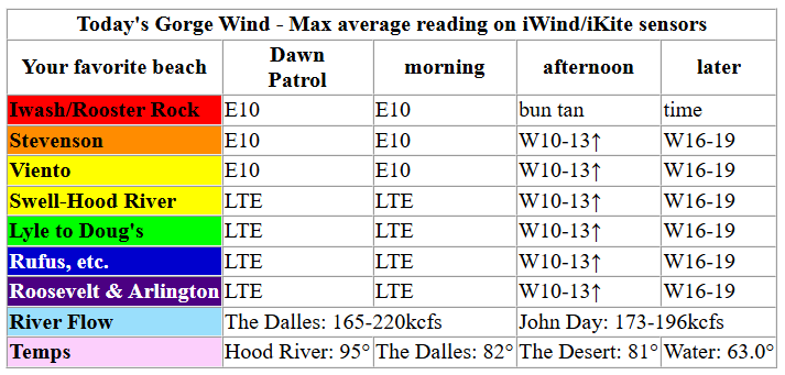
Monday started with light offshore gradients: 30.07/30.09/30.08. Easterlies were around 10mph at Iwash and Viento with variable/light wind at Stevenson. Stevenson joins at 10mph too, but that’s about it; by early afternoon, westerlies return at 10mph near Stevenson. We’ll see a slow build to 16-19mph from Stevenson to Arlington into this evening ahead of an approaching system. River flow over the last 24 hours was 165-220kcfs (173-196 at Rufus), river temp is 63.0F, and high temp forecast for Hood River is 95F.
RIVER FLOW FOR SITES BETWEEN AVERY (EAST OF THE DALLES) AND RUFUS: CLICK HERE FOR JOHN DAY DAM FLOW.
RIVER FLOW FOR SITES BETWEEN STEVENSON AND DOUG’S BEACH (WEST OF THE DALLES): CLICK HERE FOR THE DALLES DAM FLOW

LONGER-TERM gorge wind forecast

Tuesday brings cooling. Tuesday brings a weak shortwave. Tuesday brings some low clouds to the west side. Tuesday bring strong offshore high pressure. All of these factors except the shortwave are helpful. TJ and Eddy’s Dawn Patrol should be 26-29mph from Stevenson to Mosier with 22-25mph from Lyle to Arlington. As the shortwave moves through mid-morning (and pushes clouds into the western Gorge) the wind may fall and turn up-and-down for a few hours. Don’t despair. Even if there is a lull, the wind returns at 28-33mph from Viento to Boardman and eventually fills back to Stevenson as the shortwave’s low clouds burn off. High temps: 82F in Hood River and 96F in the far eastern desert.
A stable pattern sets us up for a lovely Wednesday: low clouds in the western Gorge to start, offshore high pressure, and heat from The Dalles eastward. This setup screams “CORRIDOR”. Early wind will be 19-22mph from Stevenson to The Hatch. We’ll see 23-26mph from Stevenson to Hood River by late morning with 13-16mph at Rowena. Models suggest a dip to 21-24mph in the afternoon with the wind filling in to the Rowena area. High temps: 81F in Hood River and 88F from The Dalles eastward.
Lighter wind, perhaps less than 15mph, is forecast on Thursday as heat returns. Uncertainty rears its head on Friday, but most members of the Euro ensemble bring 20+ mph west wind. About 80% of the ensemble member have a big day on Saturday. Stay tuned. See you on the Nch’i Wana soon!

Was that helpful? I knew it was! Guess what? All of this crucial work – from your personal wind and snow reports to the invaluable TATAS updates – is made possible by my relentless efforts. Maintaining this labor of love isn’t easy. Each daily forecast takes hours. Website hosting, weather model access, and back-end admin work takes time and money. That’s where you come in.
YOUR CONTRIBUTION MAKES A DIFFERENCE
- SUPPORT ACCURATE, HYPER-LOCAL WEATHER FORECASTING
- ENABLE ACCESS FOR ALL, EVEN THOSE WITH LESS MEANS
- SUPPORT A COOL HUMAN WHO WORKS HARD SO YOU CAN PLAY
Take a moment to click one of the buttons below. Donate $19.99 or more (how much does this forecast enhance your life?) and get the email in your inbox. Whether it’s a renewing subscription (auto-renew) or a one-time donation, every contribution makes a real difference. Help me keep this labor of love alive, so we can all continue playing, commuting, and living in the Gorge with peace of mind and the best weather forecasts possible. Thank you!


Hood River, Oregon 97031


JONES BEACH, SAUVIE ISLAND, & COAST FORECAST
Wind northerly unless otherwise indicated. For coast, it’s North/Central/South with the “central” at approximately Florence. Swell forecast from NWS for central coast. Jones: westerly unless otherwise stated. Sauvie Island: northerly unless otherwise stated.
Coast Monday: NNW15/N15-20/25-30, W swell 3′ @ 10 seconds. Tuesday: 15/20-25/30-40, W 3′ @ 10. Wednesday: 20-25/25-30/35-40, N 8′ @ 8 and SW 3′ @ 19. Jones Monday: 21-24. Tuesday: 16-19. Wednesday: 17-20. Sauvie Island Monday: 14-17. Tuesday: 13-16. Wednesday: 15-18.
BARE BONES HOOD RIVER WEATHER FORECAST
Partly high cloudy all day with smoke in the morning and fresh air late afternoon. Temps start in the mid 50s and rise to the mid 90s. Calm wind early. Moderate westerlies late. No rainbows. Tuesday will be clear then partly low cloudy then clear. Temps start in the mid to upper 60s and rise to the low 80s. Strong to very strong westerlies. No rainbows. Wednesday will be partly cloudy then clear. Temps start in the low 50s and rise to the low 80s. Moderately strong westerlies. No rainbows.
TEMIRA’S AWESOME TRAVEL ADVISORY SERVICE
HYPERLOCAL WEATHER FORECAST FOR THE COLUMBIA GORGE
THE DALLES, HOOD RIVER, WHITE SALMON, TROUT LAKE, STEVENSON, CASCADE LOCKS, PARKDALE, ODELL, HUSUM, BZ, MILL A, WILLARD, GOLDENDALE, RUFUS, ARLINGTON, boardman
Good morning, neighbors! Welcome to smoke season! Thanks to the 5000 acre Tule fire near Toppenish, we’ve had the earliest start to Smoke Season on record. Okay, Hood River Weather and I just started tracking this year, and we’ve decided Smoke Season starts with the first day that AQI rises over 150 in Hood River. Smoke should clear out this afternoon with the return of west wind. Then it’s on us to not make things worse – Tuesday’s wind puts us at risk for rapidly spreading fires. Don’t burn, don’t mow/weed whack with metal blades, do secure your trailer chains, and don’t pitch butts. No respite is in sight for 80+ degree weather. Cherry farmers: there’s no additional rain in sight for the next couple of weeks.
Community update
Looking around this morning, we see… the need to check in about yesterday. First, we had terrible road conditions in Hood River, where !CE kidnapped two community members, one in front of Walgreens and one in front of Hoody’s Oil on Tucker Road. Apparently !CE was in Hood River scouting a day prior, but folks didn’t know what to do. Here’s what to do (put this number in your phone): Call Portland Immigrant Rights Coalition IMMEDIATELY with make/model/color of the vehicles and plates if you can get them. Photos and videos can be texted. Number: 888-622-1510.
Glenwood and other friends this morning
Checking in with our community (somos uno) this morning, we have an extreme heat warning west of Home Valley and a Heat Advisory to the east. Most of us started the day between 50 and 60 degrees, but some notable exceptions exist: Glenwood at 45 degrees (lovely) and Middle Mountain (above the inversion) at 66 degrees (yucky). Checking in with our friends round the world:
Tehran, Iran: 93, sunny, 10% humidity
Havana, Cuba: 82, sunny, 79% humidity
Muscat, Oman: 96, sunny, 49% humidity
Caracas, Venezuela: 72, cloudy, 87% humidity
Nuuk, Greenland: 46, sunny, 79% humidity
Gaza City: 82, sunny, 59% humidity
Today’s Gorge weather forecast
On to today’s weather… HOT! Temps soar to 95F in Hood River, 100F in The Dalles, and 97F east of The Dalles. After noon, light west wind returns. By evening, we’ll have 15mph all the way from Stevenson to the Arlington Triangle. With the return of the westerlies, humidity will spike – models have the dewpoint in the upper 50s west of The Dalles this evening with 50 degree dewpoints to the east. MUGGY!
Tuesday’s Gorge weather forecast
Overnight, westerlies build in advance of a weak weather system that’ll swing through on Tuesday. Expect 60+ degree temps to start the day thanks to the wind. Tuesday’s record high-low in Hood River is 60F. This is likely to fall. GO RECORDS! Tuesday’s high temps make it to 82F in Hood River (much nicer than 95!), 88F in The Dalles (nicer than 100!), and 96F in the desert (about the same as today). Combine the dropping temps, the onshore heat gradient, and offshore high pressure for strong and dangerous west wind: 30mph west of Mosier to start with 25mph from Lyle to Arlington early. Afternoon: 30mph+ all the way from Stevenson to Hermiston. We’re under a fire weather watch on Tuesday. Why not a Red Flag Warning? Large fuels are still not quite dry enough. Even so, any fires that do start will experience rapid growth from the wind. Have a go bag ready.
Wednesday’s Gorge weather forecast and the extended Gorge weather forecast
Pleasant weather is forecast Wednesday. After a 45-55 degree start, temps rise to 81-88F, hottest from The Dalles into the desert. Folks west of Hood River start the day cloudy, and folks to the east start clear. By late morning, we’ll all be basking in sunshine under blue sky. West wind starts at 20mph between Stevenson and Hood River with less than 10mph to the east. Afternoon: 20-25mph from Stevenson to The Dalles with light wind east of The Dalles.
Heat, 90+, returns for all of us on Thursday and continues into Juneteenth and beyond. Models keep us warm and dry for the extended future. Along with Smoke Season, summer is here. Watch for !CE on the roads. Safe travels. -TATAS
HEY! DON’T STOP READING! Is this community-focused forecast helpful to you? It sure is! It takes me a couple hours a day to write. Please join your friends and neighbors in contributing to keep it going. Venmo: @thegorgeismygym PayPal: twomirrors@gmail.com USPS: Temira / PO Box 841 / Hood River, Oregon 97031 You can test out the forecast subscription for a few days for free by signing up below. Easy! Do it!
MT HOOD SNOW FORECAST

QR codes and links for end-of-season tips – thank you!!!
Cash/check: Temira – PO BOX 841 – Hood River, Oregon 97031


Leave a Reply