

GORGE WIND FORECAST
If you’re still seeing yesterday’s and it’s after 9am, try opening this in an incognito window AND/OR FLUSHING YOUR CACHE or do a do a hard refresh (Ctrl+Shift+R / Cmd+Shift+R)
SHORT-TERM gorge wind forecast

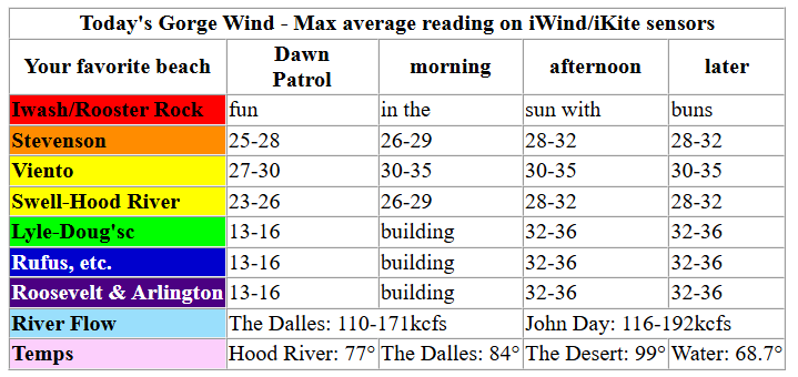
Hi friends! Nuking westerlies are on tap for the entire Gorge today – if you’re looking for lighter wind, get on it as early as possible! Today is the Gorge Downwind Champs race. If you’re recreating between Stevenson and Hood River, keep an eye upwind and yield the right of way to the racers. In general, if you are a powered craft (wind sport craft), you need to yield the right of way to a non-powered craft (paddler or empty-handed parawinger). Good luck, racers!
Yesterday’s disruptive thunderstorms have (mostly) cleared the area, and the wind was already blasting at dawn. 6am gradients were 30.01/29.85/29.81 for gradients of 0.16/0.04. Offshore: impressive 1032mb. Afternoon cross-cascade temp gradient today: 23 degrees!! Conditions are prime for a big day, including sites out east. At 653am, readings were 25 at Stevenson, 34 at Viento (reads high), and 26 at Swell (reads low) with teens near Rowena and light/variable wind east of The Dalles. Morning wind builds to 27-30mph from Stevenson to Doug’s with 24-27mph at Rufus and 20-23mph at Arlington.
Thanks to that massive afternoon temp gradient, lingering low clouds on the west side, and very strong offshore high pressure, the Gorge goes nuclear this afternoon: 28-31mph from Stevenson to Hood River with 32-36mph from Mosier to Arlington. Threemile joins at 28-31mph, and Boardman 25-28mph. Do keep an eye on the WatchDuty app today for any fire starts – this is just the sort of day where a wildfire could blow up and cause highway closures (and lots of worse things). River flow over the last 24 hours was 110-192kcfs (116-192 at Rufus), river temp is 68.7F, and high temp forecast is 77F in Hood River and 89F in Arlington.
RIVER FLOW FOR SITES BETWEEN AVERY (EAST OF THE DALLES) AND RUFUS: CLICK HERE FOR JOHN DAY DAM FLOW.
RIVER FLOW FOR SITES BETWEEN STEVENSON AND DOUG’S BEACH (WEST OF THE DALLES): CLICK HERE FOR THE DALLES DAM FLOW

LONGER-TERM gorge wind forecast
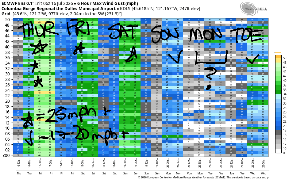
Low clouds settle in west of Hood River early Friday, offshore high pressure persists, and heat lingers in the desert. Early wind will be 17-20mph from Viento to Hood River with 10-13mph near Rowena and 18-22mph between Avery and Arlington. Mid-morning westerlies fill in at 22-25mph from Viento to Hood River with Stevenson lagging until the clouds burn off. For Friday afternoon, we’ll have 23-26mph from Stevenson to Doug’s with Rufus eventually joining in at 23-26mph. To the east, westerlies stay under 15mph from midday on. High temps: 83F in Hood River and 89F at Arlington.
Nearly identical conditions are forecast on Saturday with one change: slightly less marine layer at dawn gives us a better chance of a stronger start: dawn patrol at 21-24mph Viento-Hatch is likely followed by 23-26mph from Stevenson to Mosier in the morning. Afternoon: 23-26mph from Stevenson to Doug’s. Rufus is likely to decline participation on Saturday, but Avery should reach 20-23mph. High temp: 86F in Hood River and 92F in the desert.
Warmer weather and lesser marine clouds on Sunday still makes space for wind: call it 21-24mph focused on the Stevenson-Mosier zone. Monday looks hotter and lighter – ensembles peg it as the lightest day of the next week. We could still see 17-20mph between Stevenson and Hood River if we’re lucky. Beyond Monday, uncertainty rises, but the overall setup indicates westerlies day after day. A nice stretch of wind is on tap. Have fun. Be safe. See you on the Nch’i Wana soon!

Was that helpful? I knew it was! Guess what? All of this crucial work – from your personal wind and snow reports to the invaluable TATAS updates – is made possible by my relentless efforts. Maintaining this labor of love isn’t easy. Each daily forecast takes hours. Website hosting, weather model access, and back-end admin work takes time and money. That’s where you come in.
YOUR CONTRIBUTION MAKES A DIFFERENCE
- SUPPORT ACCURATE, HYPER-LOCAL WEATHER FORECASTING
- ENABLE ACCESS FOR ALL, EVEN THOSE WITH LESS MEANS
- SUPPORT A COOL HUMAN WHO WORKS HARD SO YOU CAN PLAY
Take a moment to click one of the buttons below. Donate $19.99 or more (how much does this forecast enhance your life?) and get the email in your inbox. Whether it’s a renewing subscription (auto-renew) or a one-time donation, every contribution makes a real difference. Help me keep this labor of love alive, so we can all continue playing, commuting, and living in the Gorge with peace of mind and the best weather forecasts possible. Thank you!


Hood River, Oregon 97031


JONES BEACH, SAUVIE ISLAND, & COAST FORECAST
Wind northerly unless otherwise indicated. For coast, it’s North/Central/South with the “central” at approximately Florence. Swell forecast from NWS for central coast. Jones: westerly unless otherwise stated. Sauvie Island: northerly unless otherwise stated.
Coast Thursday: WSW10/W10/N15-20, NW swell 4′ @ 8 seconds. Friday: LTNW/NNW10/N25-30, NW 4′ @ 7. Saturday: 15-20/20/25-30, NW 6′ @ 10. Jones Thursday: LTW. Friday: 11-14. Saturday: 15-18. Sauvie Island Thursday: LTW. Friday: 11-14. Saturday: 12-15.
BARE BONES HOOD RIVER WEATHER FORECAST
Mostly clear this morning. Sunny later. Temps start in the mid 60s and rise to the upper 70s. Blasting westerlies. No rainbows. Friday may start with a few low clouds, and then it’ll clear. Temps start in the mid 50s and rise to the low 80s. Moderate westerlies early. Moderately strong westerlies later. No rainbows. Saturday will be sunny. Temps start in the upper 50s and rise to the mid 80s. Moderately strong westerlies. No rainbows.
TEMIRA’S AWESOME TRAVEL ADVISORY SERVICE
HYPERLOCAL WEATHER FORECAST FOR THE COLUMBIA GORGE
THE DALLES, HOOD RIVER, WHITE SALMON, TROUT LAKE, STEVENSON, CASCADE LOCKS, PARKDALE, ODELL, HUSUM, BZ, MILL A, WILLARD, GOLDENDALE, RUFUS, ARLINGTON, boardman
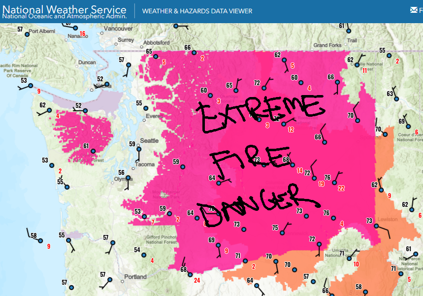
Good morning, neighbors! Dry lightning last night kicked off a few small fires locally (all under an acre as of publishing time), and now we’re in a Red Flag Warning for extreme fire danger. Be very careful out there today – the combo of dry conditions and super-strong wind will spin fires out of control quickly. On the plus side, many of us will see cooler temps today prior to yet another warming trend that starts on Friday. Long-term: rain is unlikely in the next two weeks, and the weather will be hot much of the time.
Thursday’s Gorge weather forecast
Thursday starts with some lingering thunderstorms west of Troutdale and east of Arlington with mostly clear sky and strong wind in the middle. Thankfully, cherry growers were spared significant rain last night. Lucky! Yay! Glenwood started today at a warm 55 degrees, and the rest of us were running 58-70 degrees. Wind at dawn was 25-30mph between Stevenson and Hood River. By afternoon, we’ll have 30-35mph all the way from Stevenson well past the Arlington Triangle for extreme fire danger. High temps range from 75 in Stevenson, 77 in Hood River, 84 in The Dalles, and 99 (wow) in Pasco – hence the massive west wind forecast. Stay safe!
Weather for our friends around the world
Before we move on to Friday, here’s what’s happening with our friends around the world this morning:
Bandar-e Mahshahr, Iran: 118, sunny, 8% humidity
Havana, Cuba: 84, partly cloudy, 78% humidity
Muscat, Oman: 88, sunny, 75% humidity
Caracas, Venezuela: 73, partly cloudy, 77% humidity
Nuuk, Greenland: 56, cloudy, 72% humidity
Gaza City: 85, sunny, 67% humidity
Ottawa, Canada: 72, sunny, 68% humidity
Friday-Saturday Gorge weather forecast
On Friday morning, areas west of Hood River start cloudy, and the rest of us start clear. Morning temps: 50-60 degrees. Afternoon: 80/83/89/94 (see Friday for the four locations). West wind will be 15-20mph in the morning all the way from Viento to Arlington’s Triangle. Afternoon: 25mph between Stevenson and Rufus with less to the east. Saturday looks nearly identical with slightly less morning cloud cover and 3 more degrees of afternoon heat.
Extended Gorge weather forecast
We’ll all be 90+ degrees on Sunday with clear sky, but the wind won’t stop for most: 20-25mph west of The Dalles. To the east: lighter. Except for areas west of Hood River where temps top out in the low 90s on Monday, we’ll all be 95+. Wind: probably 15-20mph. About 10 degrees of range is present in the temp forecast starting Monday. We could be merely “hot” (90-95), or we could be hot AF (95-100). Either way, models indicate continued moderate westerlies west of The Dalles with lighter wind east of The Dalles. No sign of rain or sub-80 degree weather is present in the next couple of weeks. That’s it for today. Safe travels. -TATAS
HEY! DON’T STOP READING! Is this community-focused forecast helpful to you? It sure is! It takes me a couple hours a day to write. Please join your friends and neighbors in contributing to keep it going. Venmo: @thegorgeismygym PayPal: twomirrors@gmail.com USPS: Temira / PO Box 841 / Hood River, Oregon 97031 You can test out the forecast subscription for a few days for free by signing up below. Easy! Do it!
MT HOOD SNOW FORECAST

QR codes and links for end-of-season tips – thank you!!!
Cash/check: Temira – PO BOX 841 – Hood River, Oregon 97031