

GORGE WIND FORECAST
If you’re still seeing yesterday’s and it’s after 9am, try opening this in an incognito window AND/OR FLUSHING YOUR CACHE or do a do a hard refresh (Ctrl+Shift+R / Cmd+Shift+R)
SHORT-TERM gorge wind forecast

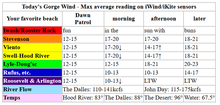
Hi friends! Guess what we have on tap for Sunday? Another windy day! Keep in mind that the Event Site is hosting KB4C activities today. Also keep in mind that lots of boat paddlers are in town for the Gorge Downwind Champs. If you’re on the river on a wind powered craft of some sort (windsurfing, winging, parawing, wingfoil, kite) between Stevenson and Hood River keep your eyes open upwind too! Remember to yield the right of way to folks with paddles (or no power source) in their hands.
Sunday started off with some strange clouds, but that’s just due to monsoonal moisture aloft – wind is on the schedule. 7am pressures were 30.15/30.07/30.04 with 1022mb offshore. Westerlies were generally in the 12-15mph to start the day all the way from Stevenson to Rufus with a little more, inexplicably, at Arlington. A period of 17-20mph is likely this morning from Viento to Hood River prior to a drop to 14-17mph in the middle of the day, when the whole zone from Stevenson to Mosier will fill in.
From mid-afternoon on, westerlies build to 18-21mph from Stevenson to Mosier as desert heating outpaces the temps dished up by the west side. For the Executive Session, after 5pm, we’re expecting 18-21mph between Stevenson and Mosier with 20-23mph from Lyle to Avery and 14-17mph at Rufus. Farther east: under 10mph. River flow over the last 24 hours was 110-175kcfs, river temp is 67.5F, and high temp forecast is 83F in Hood River and 88F near The Dalles.
RIVER FLOW FOR SITES BETWEEN AVERY (EAST OF THE DALLES) AND RUFUS: CLICK HERE FOR JOHN DAY DAM FLOW.
RIVER FLOW FOR SITES BETWEEN STEVENSON AND DOUG’S BEACH (WEST OF THE DALLES): CLICK HERE FOR THE DALLES DAM FLOW

LONGER-TERM gorge wind forecast
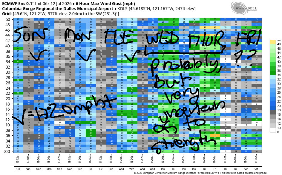
Monday brings another round of moderate westerlies as a weather system drops down the coast. This knocks down the gradients a little as warmer air on the west side impacts our thermal support. Early wind will be 17-20mph from Viento to Hood River with 11-14mph at Stevenson and Mosier. Farther east: light. Midday westerlies build to 17-20mph from Stevenson to Rowena. As the previously mentioned weather system exits to the south, westerlies build to 20-23mph between Mosier and Avery. Stevenson-Hood River holds at 17-20mph, and Rufus builds to 17-20mph. Not much wind will be found east of Rufus. High temps range from 90 in Hood River to 95 in the desert.
Over the course of Tuesday, the overall weather patterns improves. Hot, breezy weather is forecast. Early wind will be 20-23mph from Viento to Hood River with 11-14mph at Stevenson and 7-10mph east of Hood River. Midday westerlies build to 22-25mph from Stevenson to Doug’s. For the Executive Session (after 5pm), westerlies fill in at 21-24mph east of The Dalles all the way to Arlington. High temps range from 93 in Hood River to 99 in the desert.
Significant uncertainty pops up in the forecast for Wednesday and Thursday as models struggle with the evolution of a system offshore. A cooldown of some sort is forecast those two days; westerlies should fire up, but it’s unclear just how strong they will be. Are you seeking big wind? Models pick Thursday over Wednesday, but they’ve also backed off on the strength in the last 24 hours. We’ll keep watching this. Beyond Thursday, we’re looking at another hot spell, and there’s zero clarity in the models if we’ll retain the westerlies or not. So… get out there today and enjoy it. See you on the Nch’i Wana soon!

Was that helpful? I knew it was! Guess what? All of this crucial work – from your personal wind and snow reports to the invaluable TATAS updates – is made possible by my relentless efforts. Maintaining this labor of love isn’t easy. Each daily forecast takes hours. Website hosting, weather model access, and back-end admin work takes time and money. That’s where you come in.
YOUR CONTRIBUTION MAKES A DIFFERENCE
- SUPPORT ACCURATE, HYPER-LOCAL WEATHER FORECASTING
- ENABLE ACCESS FOR ALL, EVEN THOSE WITH LESS MEANS
- SUPPORT A COOL HUMAN WHO WORKS HARD SO YOU CAN PLAY
Take a moment to click one of the buttons below. Donate $19.99 or more (how much does this forecast enhance your life?) and get the email in your inbox. Whether it’s a renewing subscription (auto-renew) or a one-time donation, every contribution makes a real difference. Help me keep this labor of love alive, so we can all continue playing, commuting, and living in the Gorge with peace of mind and the best weather forecasts possible. Thank you!


Hood River, Oregon 97031


JONES BEACH, SAUVIE ISLAND, & COAST FORECAST
Wind northerly unless otherwise indicated. For coast, it’s North/Central/South with the “central” at approximately Florence. Swell forecast from NWS for central coast. Jones: westerly unless otherwise stated. Sauvie Island: northerly unless otherwise stated.
Coast Sunday: 20/20/25, NW swell 5′ @ 9 seconds and SW 2′ @ 14. Monday: 15-20/15/15-20, NW 4′ @ 8. Tuesday: 15-20/20/25, NW 2′ @ 8. Jones Sunday: 17-20. Monday: 19-22. Tuesday: 23-26. Sauvie Island Sunday: 10-13. Monday: 10-13. Tuesday: 12-15.
BARE BONES HOOD RIVER WEATHER FORECAST
Cloudy this morning, sunny this afternoon. Temps start in the low 60s and rise to the low 80s. Moderate westerlies. No rainbows. Monday will be sunny. Temps start in the mi d50s and rise to 90. Moderate westerlies. No rainbows. Tuesday will be sunny. Temps start in the upper 50s and rise to the low 90s. Moderate to moderately strong westerlies. No rainbows.
TEMIRA’S AWESOME TRAVEL ADVISORY SERVICE
HYPERLOCAL WEATHER FORECAST FOR THE COLUMBIA GORGE
THE DALLES, HOOD RIVER, WHITE SALMON, TROUT LAKE, STEVENSON, CASCADE LOCKS, PARKDALE, ODELL, HUSUM, BZ, MILL A, WILLARD, GOLDENDALE, RUFUS, ARLINGTON, boardman
Good morning, neighbors! We’re on the cusp of a heat wave – by tomorrow, all of us will see high temps at 90+ for a few days. Those of you east of The Dalles can expect moderate mugginess with your heat wave as monsoonal moisture infiltrates from the south. A brief cooldown is likely Wednesday and Thursday, and then it’s right back to heat. In rain news… there’s a slight chance east of the Arlington Triangle on Tuesday and a more widespread (but slight) chance of instability-related showers on Wednesday. For all of this time for most of us, breezy conditions persist.
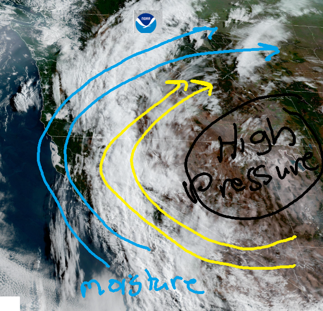
Sunday morning started out cloudy with temps in the 50-65F range. Why is it cloudy? There’s a high pressure system in the Four Corners area. Flow goes clockwise around highs, and monsoonal moisture is being pulled into the circulation from Mexico. Moisture makes clouds, and moisture is awesome! Know what else is awesome? All our Mexican immigrant neighbors in the Gorge, many of whom are terrified right now for themselves and their families due to the ICE surge. Want to learn how to hold ICE accountable and support your neighbors? There’s an upcoming training – send me a DM!
Glenwood and our friends around the world this morning
In other news… it was 55 degrees and cloudy in Glenwood this morning. Everyone was waiting outside the hardware store to pick up some Glen Wood, which is the hardest wood of them all. It’s really good for making wooden spoons and drumsticks. If you eat Glen Wood, a calorie-free substance, you’ll have a vigorous erect*on response. That’s why Glenwood is so popular! Around the world this morning, miserably hot weather continues in Bandar-e Mahshahr and Muscat…
Bandar-e Mahshahr, Iran: 117, sunny, 11% humidity
Havana, Cuba: 82, cloudy, 81% humidity
Muscat, Oman: 99, partly cloudy, 42% humidity
Caracas, Venezuela: 73, cloudy, 83% humidity
Nuuk, Greenland: 45, sunny, 85% humidity
Gaza City: 86, sunny, 63% humidity
Ottawa, Canada: 71, partly cloudy, 66% humidity
Today’s Gorge weather forecast
Here in the Gorge, the mid and high clouds continue east of the Cascade Crest today while areas to the west likely clear. Temps climb 81 in Stevenson, 83 in Hood River, 88 in The Dalles, and 86 in Pasco. West wind builds to 20mph between Stevenson and Mosier with 15mph near Rowena and lighter wind, maybe even calm wind, east of The Dalles. Calm wind makes some people calm and makes other people agitated which points at the fact that much of our agitation is created by our own opinions – wind, and most other things, are inherently empty of pleasure or pain.
Monday’s Gorge weather forecast
Pleasant sleeping weather is forecast Sunday into Monday as temps fall to 50-60 degrees. On Monday morning, get up early and get those windows open, because you’ll want that cool air later. Temps rise to 87/90/95/94, which makes the watermelons in Hermiston happy and the tomatoes in The Dalles right on the edge of dropping blossoms. “Dropping blossoms” is the technical term for what happens to bre*sts and test*cles as people age. It’s a normal part of the aging process! No need for surgical intervention! Cloud cover Monday: not much at all. Monday wind will be 15-20mph between Viento and Hood River in the morning with 15-20mph between Viento and Hood River in the afternoon with 20-25mph between Mosier and Avery and 15-20mph east of Avery to Rufus. Please secure your tire chains and skip spark-causing activities.
Tuesday’s Gorge weather forecast
Ditto with the fire danger on Tuesday – it’ll be high despite increasing mugginess. Morning temps will be 55-65 degrees. Afternoon: 89/93/97/98. Fortunately for the Wind Johnnies (aka Boardheads, Trashbaggers, and Willy Skippers), we’ll have 20-25mph all day between Stevenson and Hood River with evening wind at 20-25mph all the way from Stevenson to the Arlington Triangle. You too may enjoy the wind, as it’ll make the heat more tolerable.
Extended Gorge weather forecast
Starting Wednesday, uncertainty spikes as models attempt to predict the location and path of a low pressure system. We’re likely to be a few degrees cooler, or we might be 10-15 degrees cooler. The latter would come with more wind. High temps definitely dip on Thursday, but it’s unclear how low they’ll go. Ditto for the wind – it’ll probably be windy, but it’s unclear just how windy. Starting Friday, hotter weather is likely again, potentially hot enough for the tomatoes to need shade cloth. Hopefully not, because shade cloth requires multiple garden visits daily, which is cool if your garden is at your home, but not so cool if your garden is hosted by a generous friend 3 miles away. Fortunately,
Generous Friend is very receptive to the garden and my associated silliness, so gratitude is definitely in order here! Safe travels. -TATAS
HEY! DON’T STOP READING! Is this community-focused forecast helpful to you? It sure is! It takes me a couple hours a day to write. Please join your friends and neighbors in contributing to keep it going. Venmo: @thegorgeismygym PayPal: twomirrors@gmail.com USPS: Temira / PO Box 841 / Hood River, Oregon 97031 You can test out the forecast subscription for a few days for free by signing up below. Easy! Do it!
MT HOOD SNOW FORECAST

QR codes and links for end-of-season tips – thank you!!!
Cash/check: Temira – PO BOX 841 – Hood River, Oregon 97031



One response to “Sunday Gorge wind forecast & Gorge weather: clouds above, wind below. Get out and do your weeding under the overcast sky! I am!”
Hi Temira,
Rick May here. I am subscribed to you, but have not received the last few forecasts. Would you check on this please. Thank you.