

GORGE WIND FORECAST
If you’re still seeing yesterday’s and it’s after 9am, try opening this in an incognito window AND/OR FLUSHING YOUR CACHE or do a do a hard refresh (Ctrl+Shift+R / Cmd+Shift+R)
SHORT-TERM gorge wind forecast

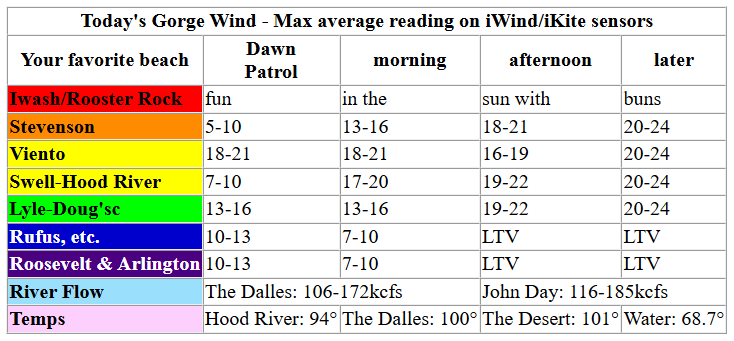
Hi friends! Hot weather with a decent breeze is in the cards for Wednesday. After a wild night of (possible) thunderstorms, we’re set for very strong west wind on Thursday. Westerlies at 20+ linger Friday and Saturday before falling a bit on Sunday in response to much hotter weather. Looking at the ensembles for the next couple of weeks, we have Monday as the lightest day with westerlies likely to pick back up again on Tuesday and linger. Fingers crossed! It is July… the windiest month in the Gorge! It’s also the most crowded month, and this week we have 800+ boat paddlers enjoying the fun as part of the Gorge Downwind Champs. Keep an eye upwind and yield the right of way, especially on Thursday, as they’re having a race!
Wednesday brings westerlies around 20mph west of The Dalles after a lighter start. Pressures early in the morning were 30.10/30.06/30.01 for gradients of 0.04/0.05. Westerlies started the day generally in the 10-13mph range all the way to Arlington with Viento the outlier at 19-22mph. By late morning, well have 17-20mph from Stevenson to the Hatch with 13-16mph in Hood River and less than 15mph near Rowena. Wind east of The Dalles will be on a downward trend all day.
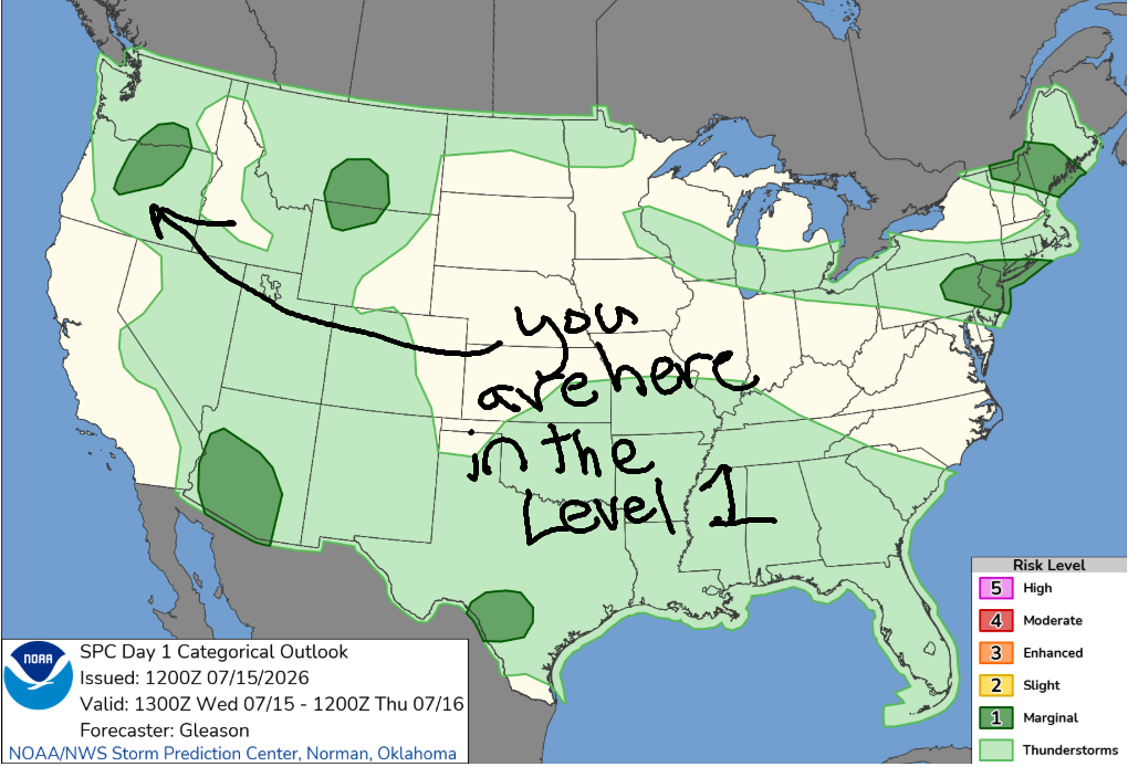
Westerlies build into the evening. Afternoon brings 19-22mph from Stevenson to Doug’s (light/variable to the east) and evening brings 20-24mph from Stevenson to Doug’s, but probably lighter near the Hatch. Sometime after 5pm or 8pm, instability enters the picture – we are under a Level 1 thunderstorm risk tonight. If you see thunderheads building, get off the water. River flow over the last 24 hours was 106-185kcfs, river temp is 68.7F, and high temp forecast is 94F for Hood River.
RIVER FLOW FOR SITES BETWEEN AVERY (EAST OF THE DALLES) AND RUFUS: CLICK HERE FOR JOHN DAY DAM FLOW.
RIVER FLOW FOR SITES BETWEEN STEVENSON AND DOUG’S BEACH (WEST OF THE DALLES): CLICK HERE FOR THE DALLES DAM FLOW

LONGER-TERM gorge wind forecast
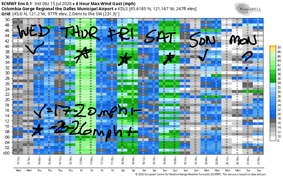
Thursday starts with lingering thunderstorm potential, but that should clear the area by 8am or 11am at the latest. We’re left with a nuker of a day! Thursday, by the way, is the Gorge Downwind Champs race. Be hyper-aware of what’s happening upwind of you if you’re playing in the river west of the Hood River Bridge. Early wind, barring thunderstorms, will be 27-30mph from Stevenson to Rufus with 22-25mph from Philippi to Threemile. Afternoon: 27-31mph from Stevenson to Hood River with 31-36mph from Mosier to Arlington and 28-32mph from Threemile to Boardman. High temps: 78F in Hood River, 85F in The Dalles, and 98F way out in the desert.
Another decent day is forecast Friday after a rather light start. Low clouds make their way into the western Gorge while sun starts the day out east. Early wind is just 11-14mph from Stevenson to Doug’s with 14-17mph from Avery to Boardman. Westerlies slowly build to 23-26mph by mid-afternoon from Stevenson to Doug’s with 20-23mph at Rufus and not much to the east. Executive session peeps (after 5pm) – the wind will hold for you too. High temps: 83F in Hood River and 90F at Rufus.
Saturday looks like a carbon copy of Friday but 5 degrees warmer. Models aren’t all that excited about Sunday (although it is many days from now), but the overall picture is good, and the wind is likely to over-perform. Let’s call it 17-20mph for now. Sunday’s wind focus will be between Stevenson and Hood River. Ensembles point at Monday as the lightest day in the next two weeks, but westerlies are likely to pick up again after that despite temps running 90-100 degrees. Sounds like a darn fine forecast. I hope you can get some time on the water. See you on the Nch’i Wana soon!

Was that helpful? I knew it was! Guess what? All of this crucial work – from your personal wind and snow reports to the invaluable TATAS updates – is made possible by my relentless efforts. Maintaining this labor of love isn’t easy. Each daily forecast takes hours. Website hosting, weather model access, and back-end admin work takes time and money. That’s where you come in.
YOUR CONTRIBUTION MAKES A DIFFERENCE
- SUPPORT ACCURATE, HYPER-LOCAL WEATHER FORECASTING
- ENABLE ACCESS FOR ALL, EVEN THOSE WITH LESS MEANS
- SUPPORT A COOL HUMAN WHO WORKS HARD SO YOU CAN PLAY
Take a moment to click one of the buttons below. Donate $19.99 or more (how much does this forecast enhance your life?) and get the email in your inbox. Whether it’s a renewing subscription (auto-renew) or a one-time donation, every contribution makes a real difference. Help me keep this labor of love alive, so we can all continue playing, commuting, and living in the Gorge with peace of mind and the best weather forecasts possible. Thank you!


Hood River, Oregon 97031


JONES BEACH, SAUVIE ISLAND, & COAST FORECAST
Wind northerly unless otherwise indicated. For coast, it’s North/Central/South with the “central” at approximately Florence. Swell forecast from NWS for central coast. Jones: westerly unless otherwise stated. Sauvie Island: northerly unless otherwise stated.
Coast Wednesday: NNW10-15/NNW10-15/N20-25, NW swell 4′ @ 8 seconds. Thursday: W10-15/LTW/N20-25, NW 4′ @ 8 and W 2′ @ 18. Friday: 10-15/20/30, NW 4′ @ 8 and W 2′ @ 17. Jones Wednesday: 25-28. Thursday: 8-11. Friday: 7-10. Sauvie Island Wednesday: 13-16. Thursday: 8-11. Friday: 10-13.
BARE BONES HOOD RIVER WEATHER FORECAST
Sunny today. Clouds increase late and thunderstorms are likely overnight. Temps start in the mid 60s and rise to the mid 90s. Moderate westerlies becoming moderately strong late. No rainbows. Thursday starts partly to mostly cloudy with a slight chance of thunder and clears by midday. Temps start in the low to mid 60s and rise to the upper 70s. Strong westerlies. 11% chance of rainbows. Friday will be mostly clear then sunny. Temps start in the mid 50s and rise to the low 80s. Light westerlies early. Moderately strong later. No rainbows.
TEMIRA’S AWESOME TRAVEL ADVISORY SERVICE
HYPERLOCAL WEATHER FORECAST FOR THE COLUMBIA GORGE
THE DALLES, HOOD RIVER, WHITE SALMON, TROUT LAKE, STEVENSON, CASCADE LOCKS, PARKDALE, ODELL, HUSUM, BZ, MILL A, WILLARD, GOLDENDALE, RUFUS, ARLINGTON, boardman
Good morning, neighbors! Darn nice morning we’re having here – plenty cool to open all the windows and doors and let the morning in. Tonight has the potential for excitement – my apologies to the orchardists for not touching on this earlier. For some reason I thought we were done picking cherries, but that was a poor assumption. More on the potential for rain in a bit. After tonight’s excitement, we’re looking at a very windy day on Thursday with high fire danger. Another warming trend arrives Friday with 95+ degrees forecast for potentially all of us starting Sunday and lingering for a while.
Glenwood this morning and our friends around the world
First, let’s talk cold: it was 50 in Glenwood this morning, which isn’t all that cold. It’s about perfect for rocking in grandpa’s old rocker on the porch and watching the sun rise. Speaking of sunrise, TATAS is in full favor of year-round DST and after-work light all year round. Please oh please can our Senators do something useful for once and pass the House bill on year-round DST?!?! Many other places in the world don’t care about changing the clocks because when you’re closer to the equator, there’s no reason… a few of our friends are examples, and here’s their weather:
Bandar-e Mahshahr, Iran: 117, sunny, 6% humidity
Havana, Cuba: 85, sunny, 76% humidity
Muscat, Oman: 90, sunny, 79% humidity
Caracas, Venezuela: 74, partly cloudy, 76% humidity
Nuuk, Greenland: 46, cloudy, 88% humidity
Gaza City: 85, sunny, 66% humidity
Ottawa, Canada: 75, cloudy, 65% humidity
Today’s Gorge weather forecast
Now, let’s look at the Gorge today. We’re under southerly flow aloft due to a high in the Four Corners. A low will swing up the coast late today and add some energy to this setup. As the low transits, wind shear (different directions and speeds) develops. All that’s to say that instability skyrockets late today and into the night resulting in thunderstorm risk. The Storm Prediction Center has Cascade Locks to Celilo Village under a Level 1 risk of severe storms. Everyone else: plain old thunderstorm risk with a bit more risk in South Wasco and the corridor leading to Bend and Madras (where they had ICE storms the last couple of days). Given the significant amount of available moisture – an inch or more – heavy downpours are possible, although the areal forecast for rain is 0.0” to 0.25”. Prime risk time is 8pm tonight to 2am on Thursday, potentially to 5am. Also possible: strong outflow wind and lightning. As always, thunderstorms will pop up wherever they want which makes locations of heavy rain impossible to predict. This is particularly annoying if you have already put out your cherry bins.
Temps today (Wednesday) max out at 89 in Stevenson, 94 in Hood River, 100 in The Dalles, and 101 in Pasco. Add in humidity – dewpoint of 50 degrees or so – for a sticky, hot day. Wind builds to 20mph between Stevenson and Murdoch this afternoon with 10-15mph in The Dalles and no wind (unless it comes from a thunderstorm) east of The Dalles.
Thursday’s Gorge weather forecast
Thursday starts with lingering storms and a mix of mid and high clouds. By mid-morning, low clouds surge into areas west of Hood River. Temps early in the morning are likely to be 65+ thanks to cloud cover. West wind will be 25-30mph right off the bat from Stevenson to Rufus with 20-25mph to Boardman. Afternoon: partly cloudy west of Hood River, mostly clear to the east, and windy AF: 30+ mph all the way from Stevenson to the Arlington Triangle with 25-30mph to Boardman. Highs range from 75 in Stevenson to 84 in The Dalles and 98 in Pasco.
Extended Gorge weather forecast
Things calm down a bit on Friday. To the west of Wyeth, the day starts cloudy. To the east: sunny. Temps will be 50-60 degrees in the morning. Afternoon: 80 in Stevenson, 83 in Hood River, 89 in The Dalles, and 93 in Pasco. West wind starts at 10-15mph west of The Dalles and 15mph east of The Dalles. Afternoon: 25mph between Stevenson and The Dalles with 15-20mph near Rufus and less to the east. Saturday looks almost identical to Friday but a few degrees warmer with a few less morning clouds.
By Sunday, the weather looks hot and sunny with highs from 90-100 degrees. West wind persists at 15-20mph west of The Dalles. To the east: calm. For next week, models suggest hot weather and moderate to moderately strong westerlies west of The Dales each day. That’ll do for now. Enjoy the storms tonight. May the rain miss the cherries! Safe travels. -TATAS
HEY! DON’T STOP READING! Is this community-focused forecast helpful to you? It sure is! It takes me a couple hours a day to write. Please join your friends and neighbors in contributing to keep it going. Venmo: @thegorgeismygym PayPal: twomirrors@gmail.com USPS: Temira / PO Box 841 / Hood River, Oregon 97031 You can test out the forecast subscription for a few days for free by signing up below. Easy! Do it!
MT HOOD SNOW FORECAST

QR codes and links for end-of-season tips – thank you!!!
Cash/check: Temira – PO BOX 841 – Hood River, Oregon 97031



Leave a Reply