

GORGE WIND FORECAST
If you’re still seeing yesterday’s and it’s after 9am, try opening this in an incognito window AND/OR FLUSHING YOUR CACHE or do a do a hard refresh (Ctrl+Shift+R / Cmd+Shift+R)
SHORT-TERM gorge wind forecast

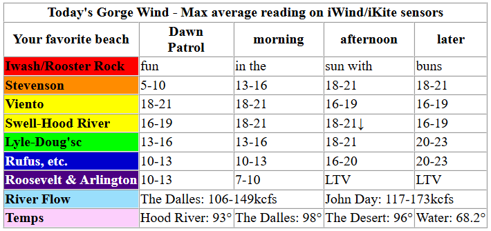
Hi friends! Hot weather is in the cards the next couple of days, but so are moderate westerlies. Stronger wind, with some potential disruptions, is forecast on Thursday. More on that in a bit. Much more settled conditions Friday and Saturday keep the westerlies blowing. Sunday: probably lighter. Beyond that, uncertainty is high in our Gorge wind forecast, but there are hints of continued westerly flow – strength is more the question than direction.
Tuesday started with pressures of 30.04/29.96/29.94 and an offshore low/high combo for gradients of 0.08/0.02. Aloft: mid and high clouds thanks to monsoonal moisture from way down south. Early wind was 15-18mph between Viento and Hood River with 10-13mph to the east and 5-10mph at Stevenson. By late morning, westerlies build to 18-21mph from Stevenson to Hood River with 13-16mph near Mosier and 13-16mph at Rowena.
Desert heating depresses the west side wind in the afternoon and nudges it up east of Hood River. We’ll finish the day with 16-19mph(ish) from Stevenson to Hood River or Mosier and 20-23mph from Lyle to Rufus. The strongest wind will wait until after 5pm as a gift to you worker bees. River flow over the last 24 hours was 106-173kcfs (117-173 at Rufus), river temp is 68.2F, and high temp forecast is 93F in Hood River.
RIVER FLOW FOR SITES BETWEEN AVERY (EAST OF THE DALLES) AND RUFUS: CLICK HERE FOR JOHN DAY DAM FLOW.
RIVER FLOW FOR SITES BETWEEN STEVENSON AND DOUG’S BEACH (WEST OF THE DALLES): CLICK HERE FOR THE DALLES DAM FLOW

LONGER-TERM gorge wind forecast
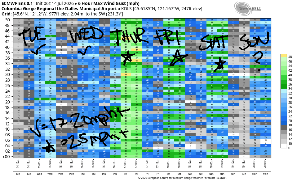
Complications enter the picture on Wednesday in the form of instability and uncertainty, but the westerlies should continue. Early wind will only be 11-14mph and only from Viento to the Hatch. Expect a slow build through the morning. After 11am, we’ll have 17-20mph from Stevenson to Doug’s. There’s some indication of a brief period of stronger wind late in the day ahead of a possible weather impulse, but models are not in a agreement on that. In addition, atmospheric instability is possible all day, and especially between 2pm and 8pm. This could impact wind quality and quantity. High temp: 93F.
Thursday’s not quite The Cooldown You Were Looking For, but it’s sure got potential for wind! Much cooler weather is forecast on the west side, and much hotter weather is forecast to the east. The Euro is pretty much all in on a BIG day. The GFS has something to say about that – it wants to bring a low overhead and destabilize the setup. With those caveats out of the way, let’s call it 80% chance of nuking. Early wind 22-25mph from Viento to Mosier. Afternoon: 30-35mph all the way from Stevenson to Arlington with a little less at Threemile and Boardman. Highs range form 82 in Hood River to the upper 90s out near Boardman. Hopefully there’s more clarity about the instability and path of the low pressure system tomorrow!
Friday looks more stable and reliable and pretty darn strong. Marine clouds make their way into the western Gorge in the morning and burn off in the afternoon. We’re probably looking at 26-29mph between Stevenson and Arlington. Slightly lesser conditions are forecast on Saturday with the focus west of The Dalles. Sunday: less windy, probably. Beyond that, I’m not making any guesses – model spread is high. Generally speaking, the flow remains westerly. Have fun! See you on the Nch’i Wana soon!

Was that helpful? I knew it was! Guess what? All of this crucial work – from your personal wind and snow reports to the invaluable TATAS updates – is made possible by my relentless efforts. Maintaining this labor of love isn’t easy. Each daily forecast takes hours. Website hosting, weather model access, and back-end admin work takes time and money. That’s where you come in.
YOUR CONTRIBUTION MAKES A DIFFERENCE
- SUPPORT ACCURATE, HYPER-LOCAL WEATHER FORECASTING
- ENABLE ACCESS FOR ALL, EVEN THOSE WITH LESS MEANS
- SUPPORT A COOL HUMAN WHO WORKS HARD SO YOU CAN PLAY
Take a moment to click one of the buttons below. Donate $19.99 or more (how much does this forecast enhance your life?) and get the email in your inbox. Whether it’s a renewing subscription (auto-renew) or a one-time donation, every contribution makes a real difference. Help me keep this labor of love alive, so we can all continue playing, commuting, and living in the Gorge with peace of mind and the best weather forecasts possible. Thank you!


Hood River, Oregon 97031


JONES BEACH, SAUVIE ISLAND, & COAST FORECAST
Wind northerly unless otherwise indicated. For coast, it’s North/Central/South with the “central” at approximately Florence. Swell forecast from NWS for central coast. Jones: westerly unless otherwise stated. Sauvie Island: northerly unless otherwise stated.
Coast Tuesday: NW10-15/NNW10-15/N20, NW swell 3′ @ 9 seconds. Wednesday: NNW10/NNW10/N20, W 3′ @ 10. Thursday: W10/W10/N10-15. Jones Tuesday: 21-24. Wednesday: 23-26. Thursday: 13-16. Sauvie Island Tuesday: 13-16 > 5pm. Wednesday: 14-17 > 5pm. Thursday: SW 10.
BARE BONES HOOD RIVER WEATHER FORECAST
Cloudy this morning. Mostly clear later. Temps start near 70 and rise to the low 90s. Moderate westerlies. No rainbows. Wednesday will be clear then partly cloudy with a slight chance of thunder. Temps start in the low 60s and rise to the low 90s. Moderate westerlies. 18% chance of rainbows. Thursday will be mostly cloudy then mostly clear. Temps start in the low 60s and rise to the low 80s. Moderately strong westerlies early. Strong later. No rainbows.
TEMIRA’S AWESOME TRAVEL ADVISORY SERVICE
HYPERLOCAL WEATHER FORECAST FOR THE COLUMBIA GORGE
THE DALLES, HOOD RIVER, WHITE SALMON, TROUT LAKE, STEVENSON, CASCADE LOCKS, PARKDALE, ODELL, HUSUM, BZ, MILL A, WILLARD, GOLDENDALE, RUFUS, ARLINGTON, boardman
Good morning, neighbors! Hot weather sticks around for a couple more days. Thunderstorms might pop up between tonight and Thursday afternoon. A brief dip in high temps Thursday and Friday takes us right back into another hot spell starting this weekend.
Today’s Gorge weather forecast, Glenwood’s start, and the weather for our friends around the world!
Looking out my window this morning… it’s sunny to the west with mid and high clouds from Underwood eastward thanks to monsoonal moisture streaming northward around the Four Corners high. Glenwood is under the clouds and 54 degrees this morning. In Hood River, it was nearly 70 this morning, which explains why I felt so warm all night despite open windows and fans. If you like it warm, you’ll like this afternoon: 89 in Stevenson, 93 in Hood River, 98 in The Dalles, and 96 in Pasco. West wind rises to 15-20mph by late morning and fills in between Stevenson and Rufus by evening. That will help you feel somewhat cooler, but the dewpoint will not: expect muggy weather west of The Dalles with the dewpoint climbing to 50 degrees by this evening. Speaking of hot and muggy… around the world, we have hot, humid weather in many of the places we’re learning to love:
Bandar-e Mahshahr, Iran: 123, sunny, 7% humidity
Havana, Cuba: 81, cloudy, 82% humidity
Muscat, Oman: 94, partly cloudy, 67% humidity
Caracas, Venezuela: 72, partly cloudy, chance of rain, 85% humidity
Nuuk, Greenland: 48, partly cloudy, 83% humidity
Gaza City: 86, sunny, 61% humidity
Ottawa, Canada: 76, partly cloudy, 82% humidity
Wednesday’s Gorge weather forecast
The Wednesday-Thursday forecast is a bit uncertain thanks to model disagreement on the path of an offshore low. Here’s the broad-brush picture: on Wednesday, it’ll still be hot and muggy (60-70 for lows, 90-99 for highs) and breezy (15-20mph west of Avery). However… the timing and path of this low will make all the difference in precipitation possibility – we do have a chance of thunderstorms popping up late Tuesday night into, potentially, Thursday morning.
Thursday’s Gorge weather forecast
On Thursday, high temps drop to 80 in Stevenson and Hood River, 89 in The Dalles, and 97 in the desert. Cool air plows into the metro area and combines with the desert heat for very strong west wind. Fire danger will be extreme. In addition, there’s a slight chance of thunderstorms in the morning before conditions stabilize in the afternoon. Expect a mostly cloudy start followed by partly cloudy sky west of Hood River and sun to the east.
Extended Gorge weather forecast
The weather settles in and settles down on Friday. Expect sunshine, temps in the 82-94 range (hottest in Pasco), and strong west wind. Add 3-5 degrees of warmth for Saturday and repeat the rest of the forecast. Heat, 90-100 for The Dalles, persists into the middle of next week, when slight cooling trend is possible, but uncertainty is high. Safe travels. -TATAS
HEY! DON’T STOP READING! Is this community-focused forecast helpful to you? It sure is! It takes me a couple hours a day to write. Please join your friends and neighbors in contributing to keep it going. Venmo: @thegorgeismygym PayPal: twomirrors@gmail.com USPS: Temira / PO Box 841 / Hood River, Oregon 97031 You can test out the forecast subscription for a few days for free by signing up below. Easy! Do it!
MT HOOD SNOW FORECAST

QR codes and links for end-of-season tips – thank you!!!
Cash/check: Temira – PO BOX 841 – Hood River, Oregon 97031



Leave a Reply