

GORGE WIND FORECAST
If you’re still seeing yesterday’s and it’s after 9am, try opening this in an incognito window AND/OR FLUSHING YOUR CACHE or do a do a hard refresh (Ctrl+Shift+R / Cmd+Shift+R)
SHORT-TERM gorge wind forecast
Hi friends! Hot, east-wind weather continues today. By Monday afternoon, we’re back to westerlies. Models still have their hands on the scales for Tuesday – a big west wind day is in the cards all the way from Stevenson to Threemile and perhaps beyond. Models suggest the Corridor will be the place to be on Wednesday. Beyond that, there’s quite a bit of uncertainty in the models; they seem to think Thursday will be a light wind day with stronger wind next Friday and Saturday, but the range of possible outcomes is quite high.
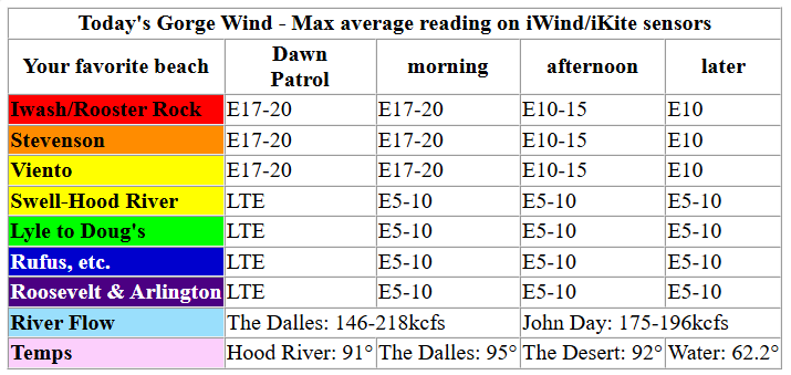
Looking at Sunday morning, we’ve got easterlies at 15mph at Viento and Stevenson and 10mph at Iwash/Rooster to start. Iwash picks up to 20mph mid-morning, Stevenson rises to 17-20mph, and Viento hangs around 15mph. The wind starts to fade after mid-morning. By afternoon, all areas will be down to 10mph; from Hood River eastward, the wind builds to 7-10mph after mid-morning. River flow over the last 24 hours was 146-218kcfs (175-196 at Rufus), river temp is 62.2F, and high temp forecast is 91F in Hood River.
RIVER FLOW FOR SITES BETWEEN AVERY (EAST OF THE DALLES) AND RUFUS: CLICK HERE FOR JOHN DAY DAM FLOW.
RIVER FLOW FOR SITES BETWEEN STEVENSON AND DOUG’S BEACH (WEST OF THE DALLES): CLICK HERE FOR THE DALLES DAM FLOW

LONGER-TERM gorge wind forecast
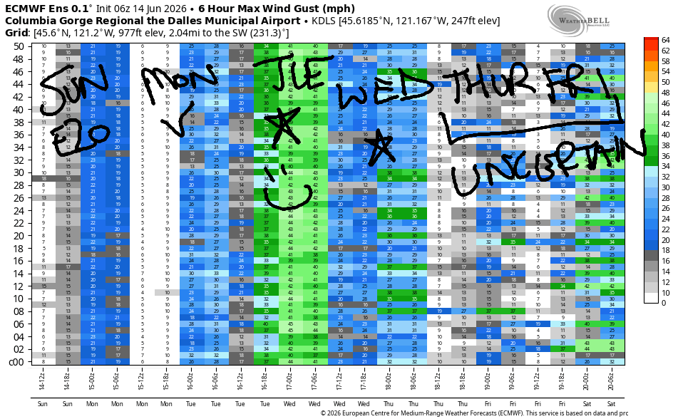
Monday starts dead calm. Quick! Get out there and do whatever you like to do in glassy conditions! In the afternoon, a low moves towards BC and a shortwave approaches us. This gives us hair-dryer westerlies at 17-20mph from Stevenson to Doug’s and 14-17mph from Avery to Rufus. It’s possible we could see 18-22mph from Stevenson to Rufus with 14-17mph at Arlington for the Executive Session after 5pm. High temp: 96F.
That shortwave moves inland on Tuesday morning and drags a few low clouds into the western Gorge and metro area mid-morning. This will reinforce the early wind, which will already be strong. TJ and Eddy’s Dawn Patrol starts with 26-29mph from Stevenson to Mosier with 23-26mph as far east as Rufus. Afternoon: 30-33mph all the way from Stevenson to Threemile and 27-30mph at Boardman. It’s possible there could be a slight dip as the system moves inland, but it’ll all work out before and after that. High temps: 83F in Hood River and low to mid 90s east of The Dalles. Consider a water pack for your downwinding excursions!
As of this morning, models suggest morning marine clouds on Wednesday with a 26-29mph Dawn Patrol. There are signs the wind will fade in the afternoon, but either way, it’ll be a windy one. Significant uncertainty exists around Thursday, and uncertainty continues beyond that. However, Friday and Saturday both look likely to be solid westerly days per the Euro ensemble. That’s enough for today. See you on the Nch’i Wana soon!

Was that helpful? I knew it was! Guess what? All of this crucial work – from your personal wind and snow reports to the invaluable TATAS updates – is made possible by my relentless efforts. Maintaining this labor of love isn’t easy. Each daily forecast takes hours. Website hosting, weather model access, and back-end admin work takes time and money. That’s where you come in.
YOUR CONTRIBUTION MAKES A DIFFERENCE
- SUPPORT ACCURATE, HYPER-LOCAL WEATHER FORECASTING
- ENABLE ACCESS FOR ALL, EVEN THOSE WITH LESS MEANS
- SUPPORT A COOL HUMAN WHO WORKS HARD SO YOU CAN PLAY
Take a moment to click one of the buttons below. Donate $19.99 or more (how much does this forecast enhance your life?) and get the email in your inbox. Whether it’s a renewing subscription (auto-renew) or a one-time donation, every contribution makes a real difference. Help me keep this labor of love alive, so we can all continue playing, commuting, and living in the Gorge with peace of mind and the best weather forecasts possible. Thank you!


Hood River, Oregon 97031


JONES BEACH, SAUVIE ISLAND, & COAST FORECAST
Wind northerly unless otherwise indicated. For coast, it’s North/Central/South with the “central” at approximately Florence. Swell forecast from NWS for central coast. Jones: westerly unless otherwise stated. Sauvie Island: northerly unless otherwise stated.
Coast Sunday: 20/25/unknown due to possible southerly marine push, N 7 @ 7 and W 2 @ 11. Monday: 15-20/20/25-30, W 3′ @ 10. Tuesday: 15-20/20/35, N 8′ @ 8, SW 2′ @ 14, SW 2′ @ 19. Jones Sunday: LTV. Monday: 23-26. Tuesday: 17-20. Sauvie Island Sunday: 8-11. Monday: 15-18. Tuesday: 15-18.
BARE BONES HOOD RIVER WEATHER FORECAST
Mostly clear today. Temps start in the low 50s and rise to the low 90s. Light easterlies. No rainbows. Monday will be partly high cloudy. Temps start in the low 60s and rise to the mid 90s. Calm wind early. Moderate westerlies later. No rainbows. Tuesday will be sunny. A few low clouds may drift in before the sky clears again. Temps start in the mid 60s and rise to the low 80s. Strong to very strong westerlies. No rainbows.
TEMIRA’S AWESOME TRAVEL ADVISORY SERVICE
HYPERLOCAL WEATHER FORECAST FOR THE COLUMBIA GORGE
THE DALLES, HOOD RIVER, WHITE SALMON, TROUT LAKE, STEVENSON, CASCADE LOCKS, PARKDALE, ODELL, HUSUM, BZ, MILL A, WILLARD, GOLDENDALE, RUFUS, ARLINGTON, boardman
Good morning, neighbors! Get up and get your windows and doors open. Trap some cool air before it’s gone! We’re looking at hot weather today and Monday almost everywhere in the PNW with 85+ degree heat continuing east of Hood River on Tuesday and beyond. No rain is forecast in the next couple of weeks. On Tuesday, we have a super windy day in the cards, 30+ mph all through the Gorge, for very concerning fire weather conditions.
Glenwood and our friends around the world this morning
Starting with Sunday morning… Glenwood began this day with 43 degrees. They were very, very, very happy and well rested after such a cool night! Our other friends around the world are like this as of the time of this forecast being written:
Tehran, Iran: 93, sunny, 10% humidity
Havana, Cuba: 82, partly cloudy, 78% humidity
Muscat, Oman: 93, sunny, 71% humidity
Caracas, Venezuela: 74, cloudy, 69% humidity
Nuuk, Greenland: 48, sunny, 71% humidity
Gaza City: 79, sunny, 72% humidity
Today’s Gorge weather forecast
Folks low down and west of Hood River were 60+ degrees. There’s an inversion in place, and some higher locations are also above 60F. Get aggressive with your cold air storage, people. By afternoon, we’re looking at 90-95 degrees all through the Gorge. Some escape is possible by heading up into the mountain at 5000′, where temps should be around 70F. You can also escape the heat by heading to the cold storage at Lage Orchards or McCurdy Farms (don’t actually do that, okay?) Today’s wind maxes out at 15-20mph at Iwash, Stevenson, and Viento with 10mph east of Viento out into the desert. Ditto in the hills: 10-15mph. At least it won’t be muggy for most of us – dewpoints remain in the 30s or 40s. Exception: late in the day, dewpoints rise to the low 60s west of Hood River. MUGGY!
Monday’s Gorge weather forecast
Overnight, models suggest partly high overcast sky and temps that fall to the low 60s by Monday morning. We’ll have quite a few thin high clouds thanks to a system near BC. This sets us up for a very colorful sunrise at 5:16am. High clouds stick around all day but do nothing to dampen the heat. 96-100F is the forecast all the way from the west side to Pasco. Monday’s wind starts as calm as a cat sleeping in a sunbeam. Afternoon brings west wind at 15-20mph between Stevenson and Arlington. With the return of the west wind, humidity will skyrocket – dewpoints are forecast to rise to the mid 50s. Stake out a swimming hole, because oppressive heat and humidity is planned for Monday afternoon.
Tuesday’s Gorge weather forecast
A weak weather system is forecast for Tuesday. High temps respond by diving for cover. Unfortunately, the combo of humidity and westerlies will start the day very warm – record high-low temps are likely to fall. Call it 65F and humid to start. Afternoon temps max out in the low 80s west of Mosier, upper 80s in The Dalles, and mid 90s out in Pasco. Our biggest concern Tuesday is very strong west wind: 25-30mph right off the bat from Stevenson to Mosier with 25mph to Rufus and 20mph to Arlington. Afternoon wind rises to 30-35mph all the way from Stevenson to Boardman. While large fuels, according to NWS, aren’t dry enough for a Red Flag Warning, things are dry out there. Combine that with the wind, and we’re looking at huge fire danger Tuesday. Please secure trailer chains – when they drag, they make sparks, and that starts fires. Don’t burn stuff. Don’t toss cigarette buts. Skip the mowing and metal-blade weed whacking. If you want to be extra prepared, toss five gallons of water (contained, not loose) and a shovel in your car. Fingers crossed for no fire starts!
Extended Gorge weather forecast
Wednesday brings another windy day, especially west of The Dalles. Temps max out in the 82-89F range. Uncertainty increases in the weather models after Wednesday, but “warm” is a good description of what’s planned for the extended forecast. For now, there’s no sign of significant rain or thunderstorms through the 28th. Okay, peeps. Find your sunscreen, shades, and swim trunks and stake out a swimming hole. Safe travels. -TATAS
HEY! DON’T STOP READING! Is this community-focused forecast helpful to you? It sure is! It takes me a couple hours a day to write. Please join your friends and neighbors in contributing to keep it going. Venmo: @thegorgeismygym PayPal: twomirrors@gmail.com USPS: Temira / PO Box 841 / Hood River, Oregon 97031 You can test out the forecast subscription for a few days for free by signing up below. Easy! Do it!
MT HOOD SNOW FORECAST

QR codes and links for end-of-season tips – thank you!!!
Cash/check: Temira – PO BOX 841 – Hood River, Oregon 97031


Leave a Reply