

GORGE WIND FORECAST
If you’re still seeing yesterday’s and it’s after 9am, try opening this in an incognito window
SHORT-TERM gorge wind forecast

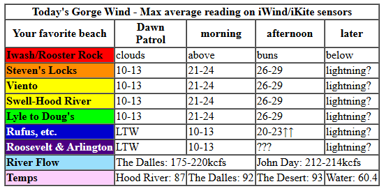
Hi friends! Super fun shredding with you yesterday morning! We’ll continue with community shred sessions today, tomorrow, Saturday, and Sunday. Looks like the wind will back off for a couple days to start next week (great timing, as I’m in an online training all day Monday and Tuesday) before picking up again in the middle of next week. Uncertainty remains high after Tuesday, so I can’t give you any deets. Let’s start where I can give you all the goods in the Gorge wind forecast: today…
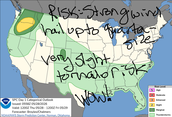
Thursday kicked off with light westerlies and pressures of 29.83/29.76/29/74 with 30.24 offshore. All the big wind-causing action takes place in the desert today – a low moving in from the south combines with heat-caused lower pressure in the desert for big afternoon gradients. Today’s big caveat is atmospheric instability driven by that incoming low – we are under a very unusual Level 2 from the Storm Prediction Center today for severe thunderstorms this evening. You’ll want to be off the water before that happens!
By mid-morning, we’ll have 20-23mph from Stevenson to Mosier with 10-13mph from Lyle to Doug’s and less to the east. The wind keeps building into the afternoon. If the pieces fall into place just right, westerlies skyrocket early afternoon: 26-29mph from Stevenson to Hood River with 29-32mph from Mosier to Avery and 20-23mph at Rufus. Given the lack of clouds in the metro area and surface instability, the Hatch is likely to under-perform. If things don’t fall apart prior to 5pm, we could see 30-33mph this afternoon from Stevenson to Rufus.
When the storms start to near our area (they’re coming from the SSE), all bets are off on the wind. And you don’t want to mess with these storms – there’s going to be a lot of lightning. What an awesome weather day this will be! River flow over the last 24 hours was 175-220kcfs (212-214kcfs at Rufus), river temp is 60.4F, and high temp forecast is 87F in Hood Rive rand 93F in the desert.
RIVER FLOW FOR SITES BETWEEN AVERY (EAST OF THE DALLES) AND RUFUS: CLICK HERE FOR JOHN DAY DAM FLOW.
RIVER FLOW FOR SITES BETWEEN STEVENSON AND DOUG’S BEACH (WEST OF THE DALLES): CLICK HERE FOR THE DALLES DAM FLOW

LONGER-TERM gorge wind forecast
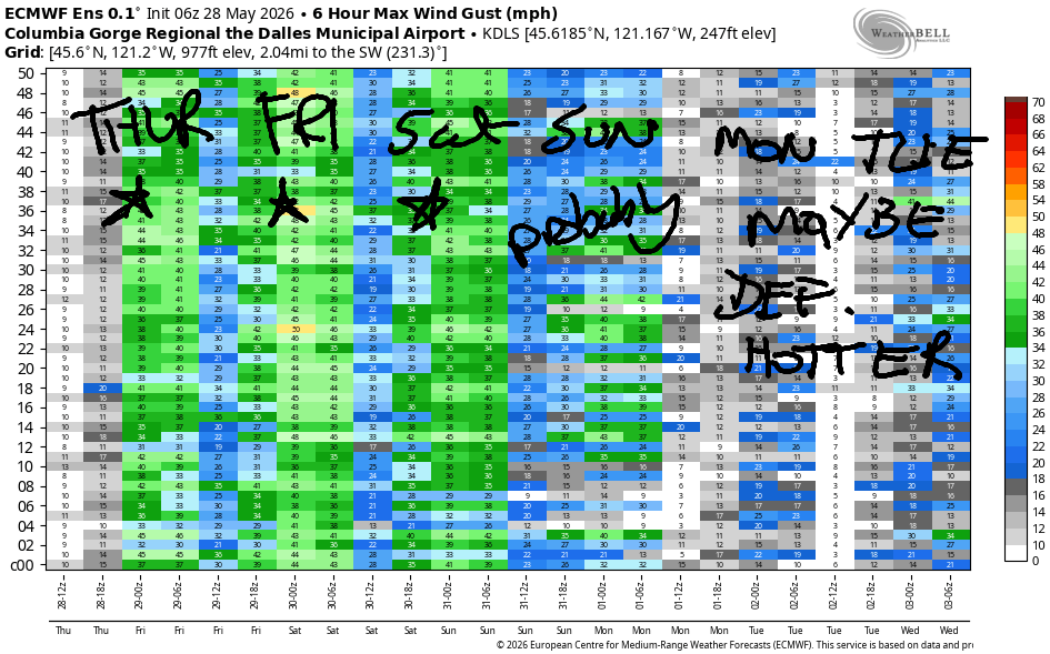
Friday sees a cold front come in from the west with abundant low clouds and stabilizing air. Drizzle is likely as far east as Avery in the morning, which will push your morning session to the east. We start with gusty 20-26mph from Viento to Hood River, 20-23mph from Lyle to Doug’s, and 28-31mph from Avery to Hermiston. Afternoon wind builds to 26-29mph from Stevenson to Mosier with 29-33mph from Lyle to Hermiston. Models suggest the wind will linger into the evening with a slight decreases for areas east of Lyle. High temp: 64F in Hood River (down over 20 degrees from Thursday!!!) and 75F in the desert.
On Saturday, we have a lovely setup: offshore high pressure, low clouds on the west side, and somewhat warmer conditions in the desert. Early wind will be 19-22mph from Stevenson to Rowena with 12-15mph east into the desert. Afternoon: 23-26mph from Stevenson to Avery with 10-13mph at Rufus. Given lingering low clouds and offshore high pressure at 1028mph (right on the edge of strong enough for good surprises), we could see reality beat the models. High temp: 66F in Hood River and 73F in the desert.
Models give us 23-26mph on Sunday, likely strongest near the Hatch and definitely with a shot at over-performing conditions. Lesser wind is forecast on Monday and Tuesday as hotter weather takes over. As of right now, conditions look pretty light on Monday and Tuesday with stronger wind forecast on Wednesday. Here’s hoping we eek out just enough wind for folks to get on the river with the warm temps at the start of the week. See you on the Nch’i Wana soon!

Was that helpful? I knew it was! Guess what? All of this crucial work – from your personal wind and snow reports to the invaluable TATAS updates – is made possible by my relentless efforts. Maintaining this labor of love isn’t easy. Each daily forecast takes hours. Website hosting, weather model access, and back-end admin work takes time and money. That’s where you come in.
YOUR CONTRIBUTION MAKES A DIFFERENCE
- SUPPORT ACCURATE, HYPER-LOCAL WEATHER FORECASTING
- ENABLE ACCESS FOR ALL, EVEN THOSE WITH LESS MEANS
- SUPPORT A COOL HUMAN WHO WORKS HARD SO YOU CAN PLAY
Take a moment to click one of the buttons below. Donate $19.99 or more (how much does this forecast enhance your life?) and get the email in your inbox. Whether it’s a renewing subscription (auto-renew) or a one-time donation, every contribution makes a real difference. Help me keep this labor of love alive, so we can all continue playing, commuting, and living in the Gorge with peace of mind and the best weather forecasts possible. Thank you!


Hood River, Oregon 97031


JONES BEACH, SAUVIE ISLAND, & COAST FORECAST
Wind northerly unless otherwise indicated. For coast, it’s North/Central/South with the “central” at approximately Florence. Swell forecast from NWS for central coast. Jones: westerly unless otherwise stated. Sauvie Island: northerly unless otherwise stated.
Coast Thursday: NNW15-20/10-15/LTV, NW swell 11′ at 17 seconds, wow! Friday: 15/15/25-30, NW 8′ @ 14. Saturday: 15-20/20/30-35, NW 6′ @ 12. Jones Thursday: 25-28. Friday: 21-24. Saturday: 21-24. Sauvie Island Thursday: 15-18. Friday: 13-16. Saturday: 13-16.
BARE BONES HOOD RIVER WEATHER FORECAST
Clear this morning. A few clouds later. Thunderstorms this evening. Temps start in the low 60s (WARM!) and rise to the upper 80s (HOT – close windows!). Light westerlies early. Strong later. No rainbows. Friday will be showery/drizzly early and partly cloudy later. Temps start in the low 50s and rise to the mid 60s. Strong westerlies. 78% chance of rainbows. Saturday will be cloudy then mostly clear. Temps start in the low 40s and rise to the mid 60s. Moderate to moderately strong westerlies. No rainbows.
TEMIRA’S AWESOME TRAVEL ADVISORY SERVICE
HYPERLOCAL WEATHER FORECAST FOR THE COLUMBIA GORGE
THE DALLES, HOOD RIVER, WHITE SALMON, TROUT LAKE, STEVENSON, CASCADE LOCKS, PARKDALE, ODELL, HUSUM, BZ, MILL A, WILLARD, GOLDENDALE, RUFUS, ARLINGTON, boardman
Good morning, neighbors! We have quite a day on tap – beautiful weather followed by one heck of a thunderstorm show this evening. Things settle down Friday morning as a cold front swings through and stabilizes the atmosphere. Accompanying the stability: drizzle, strong wind, and much cooler weather. Windy, pleasant, not-too-hot weather persists through the weekend, and then warmer weather is forecast to start next week.
All our friends this morning
Checking in with friends this morning, we have… 47F in Glenwood, just warm enough for nudity while brewing coffee. In Tehran, our terrified friends are expecting 88F and 15% humidity – the weather is pretty damned nice there day after day. Havana, as usual, is set for mugginess: 83 degrees and 79% humidity with a chance of thunderstorms. In Muscat, Oman, the forecast is for 104 degrees with 27% humidity, which is going to feel pretty darn hot and sticky while people are processing the US president’s statements about bombing Oman. Yesterday’s peak planetary heat was 122F in Jacobabad, Pakistan, where it’s forecast to be 117F tomorrow and never below 105F this week. This isn’t really a surprise – it’s one of the hottest places on earth!
Today’s Gorge weather forecast
If you’re not quite ready for summer heat, today may feel like you’re in one of the hottest places on earth! Early in the morning, the dewpoint was 53F in Hood River, and it’s forecast to rise to 55F. Temps max out around 87F (Hood River) and 92-93F (The Dalles eastward). “Sticky” describes this afternoon’s heat – it’s gonna feel quite muggy. It might be the first AC day of the year! At least it’ll be windy: 25-35mph this afternoon (prior to instability arriving, anyway) all the way from Stevenson to Rufus. To the east of Rufus, the wind holds off until after 5pm (probably) and then storms out of the south ahead of an incoming low with 30+ mph. Unless you’re a highly skilled boardhead, you do not want to be on the Nch’i Wana this afternoon!
Let’s talk thunderstorms: all that moisture is fuel for the fire when a system moving in from the south triggers instability this evening. Everything comes together for a decent chance of severe thunderstorms after 5pm. We’re expecting strong storms, copious lightning, periods of pouring rain, strong outflow wind, and hail up to the size of a quarter. SPC even mentioned the possibility of a tornado! Storms start in the 5am-8pm window and continue into late evening.
Friday’s Gorge weather forecast
They’re stopped by an incoming cold front from the west that stabilizes the air mass early on Friday. This drags low clouds into the western Gorge. Temps start in the upper 40s to mid 50s on Friday morning west of the Cascades with much warmer temps possible to the east. Drizzle is likely as far east as Celilo Village in the morning. By afternoon, we dry out, Most of the clouds burn off, and we’re left with partly cloudy sky. High temps range from 64F (Hood River) to 68F (The Dalles) and 75F (The Desert). Combine the west-side clouds and cool air with east side heat and a departing low and offshore high pressure for very strong west wind: 20-30mph in the morning from Viento to Hermiston with 30-35mph in the afternoon. Given the abundant lightning Thursday night and strong wind Friday, wildfires are likely. Have your go bag ready and keep an eye on WatchDuty.
Extended Gorge weather forecast
Calmer weather is forecast on Saturday. We’ll start with clouds to the west and partly cloudy sky east of Mosier. Temps at 850mb (~5000′) are forecast to be somewhere in the 0C to +2C range, which puts Glenwood and Dufur at 30-34F. Upper Valley: 35-39F if it’s clear. Otherwise, warmer. Afternoon sees temps rise to 66-73F, coolest to the west and warmest in the desert. Morning wind will be 15-20mph to Rowena with 10-15mph east to Arlington. Afternoon: 25-30mph from Stevenson to Avery with less to the east. Windy, 70-75 degrees weather is forecast Sunday. Warmer, less windy weather returns Tuesday and Wednesday after which uncertainty rises. So let’s stop there for today. Enjoy the storm watching tonight. Safe travels! -TATAS
HEY! DON’T STOP READING! Is this community-focused forecast helpful to you? It sure is! It takes me a couple hours a day to write. Please join your friends and neighbors in contributing to keep it going. Venmo: @thegorgeismygym PayPal: twomirrors@gmail.com USPS: Temira / PO Box 841 / Hood River, Oregon 97031 You can test out the forecast subscription for a few days for free by signing up below. Easy! Do it!
MT HOOD SNOW FORECAST

QR codes and links for end-of-season tips – thank you!!!
Cash/check: Temira – PO BOX 841 – Hood River, Oregon 97031