

GORGE WIND FORECAST
If you’re still seeing yesterday’s and it’s after 9am, try opening this in an incognito window
SHORT-TERM gorge wind forecast
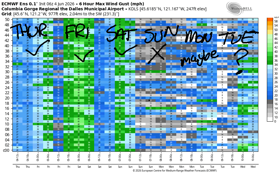
Hi friends! The wind took its sweet time arriving yesterday, but the Executive Session at the Hatch was pretty darn good! Lesser wind is in the Gorge wind forecast today as brief high pressure builds inland. A low moving this way on Friday sets up a strong cross-Cascade temperature gradient and a five-degree cooldown over today; this isn’t The Cooldown You Were Looking For, but it will bring us wind. Westerlies continue on Saturday, and then the wind drops to the light/variable zone on Sunday in response to rain. Looking beyond that, there’s quite a bit of uncertainty; westerlies of some sort are likely through Thursday or potentially Friday, when a warming trend might shut things down. We’ll have to see how this plays out….
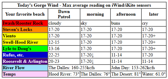
Thursday started with pressures of 30.22/30.15/30.10 and 1029mb offshore for 0.07/0.05. A few marine clouds were floating past Hood River. Westerlies were 22-25mph from Rufus to Arlington; 15-20mph in the Rowena zone, and 10-20mph in the cloudy zone between Stevenson and Mosier. We do expect the clouds to burn back today, meaning the wind between Rufus and Arlington is going to drop. Models suggest a drop in wind mid-morning, but I’m going out on a limb with 17-20mph from Stevenson to Doug’s all the way into early afternoon. East of Doug’s, the wind is going to drop to 11-14mph by late morning.
Afternoon wind has a shot at building to 20-23mph from Stevenson to Doug’s (although the Hatch is likely to drop when the metro area clears) with 17-20mph from Avery to Rufus after 5pm. River flow over the last 24 hours was 153-262kcfs, lowest early this morning. River temp is 61.0F, and high temp forecast is 73F for Hood River and 81F for Pasco.
RIVER FLOW FOR SITES BETWEEN AVERY (EAST OF THE DALLES) AND RUFUS: CLICK HERE FOR JOHN DAY DAM FLOW.
RIVER FLOW FOR SITES BETWEEN STEVENSON AND DOUG’S BEACH (WEST OF THE DALLES): CLICK HERE FOR THE DALLES DAM FLOW

LONGER-TERM gorge wind forecast
Friday starts off cool and cloudy with a true Dawn Patrol (prior to 8am) possible at 20-23mph at the Hatch. By 8am, we’re looking at 13-16mph from Stevenson to Doug’s with 19-22mph from Avery to Arlington. Late morning wind rises to 26-29mph from Lyle to Arlington with 20-23mph at Threemile. An approaching system is likely to knock the wind down below 15mph between Stevenson and Mosier. In the afternoon, the wind stays light west of Lyle and rises to gusty 27-30mph from Lyle to Arlington with 23-26mph from Threemile to Hermiston. If someone could knock the current down to 150kcfs or less at Rufus on Friday, I’d be so appreciative! Highs range from 67F in Hood river to 78F in Hermiston with clouds all day in the western Gorge and partly high overcast sky in the afternoon out east.
Saturday brings some rain to the west side and partly cloudy sky to the east side. This keeps the strongest wind east of Hood River. Early wind will be 7-10mph west of Lyle with 18-22mph from Lyle to Threemile. Afternoon: 13-16mph from Stevenson to Mosier with 27-31mph from Lyle to Threemile. As always, keep in mind that the Hatch sensor reads low compared to those out-east sensors; 27-30mph at Rufus, Arlington, or Threemile is more like 20-24mph at the Hatch. High temp Saturday: 62F in Hood River (with intermittent rain) and 72F in the desert.
Sunday is likely to be calm or light/variable. Monday starts light and picks up to the upper teens or low 20s. Lots of uncertainty exists beyond that. Generally speaking, some sort of westerlies stick around for the first half of next week, most likely, but there’s also a chance of rain. Warmer weather is forecast for the second half of next week, but predicting the wind really depends on the exact orientation of an incoming ridge, so I”m not going to try – with heat, we’re generally looking at Corridor wind (near Hood River), and ensembles are useless for that. Have a great day on the Nch’i Wana today – see you out there soon!

Was that helpful? I knew it was! Guess what? All of this crucial work – from your personal wind and snow reports to the invaluable TATAS updates – is made possible by my relentless efforts. Maintaining this labor of love isn’t easy. Each daily forecast takes hours. Website hosting, weather model access, and back-end admin work takes time and money. That’s where you come in.
YOUR CONTRIBUTION MAKES A DIFFERENCE
- SUPPORT ACCURATE, HYPER-LOCAL WEATHER FORECASTING
- ENABLE ACCESS FOR ALL, EVEN THOSE WITH LESS MEANS
- SUPPORT A COOL HUMAN WHO WORKS HARD SO YOU CAN PLAY
Take a moment to click one of the buttons below. Donate $19.99 or more (how much does this forecast enhance your life?) and get the email in your inbox. Whether it’s a renewing subscription (auto-renew) or a one-time donation, every contribution makes a real difference. Help me keep this labor of love alive, so we can all continue playing, commuting, and living in the Gorge with peace of mind and the best weather forecasts possible. Thank you!


Hood River, Oregon 97031


JONES BEACH, SAUVIE ISLAND, & COAST FORECAST
Wind northerly unless otherwise indicated. For coast, it’s North/Central/South with the “central” at approximately Florence. Swell forecast from NWS for central coast. Jones: westerly unless otherwise stated. Sauvie Island: northerly unless otherwise stated.
Coast Thursday: NW10/NNW10-15/N25-30, W swell 5′ at 10 seconds and SW 2′ @ 16. Friday: W10-15/NW10/N20, SW 2′ @ 18. Saturday: W10/W10/N15-20, W 6′ @ 9 and SW 2′ @ 17. Jones Thursday: 12-15. Friday: LTW. Saturday: LTW. Sauvie Island Thursday: 12-15 > 5pm. Friday: W 10-13. Saturday: W 15-18.
BARE BONES HOOD RIVER WEATHER FORECAST
Mostly clear this morning. Clear this afternoon. Temps start in the mid 50s and rise to the low 70s. Moderate westerlies. No rainbows. Friday will be mostly cloudy. Temps start in the upper 40s and rise to the upper 60s. Moderate westerlies. No rainbows. Saturday will be cloudy with intermittent sprinkles or drizzle. Temps start in the upper 40s and rise to the low 60s. Light westerlies. 99% chance of rainbows.
TEMIRA’S AWESOME TRAVEL ADVISORY SERVICE
HYPERLOCAL WEATHER FORECAST FOR THE COLUMBIA GORGE
THE DALLES, HOOD RIVER, WHITE SALMON, TROUT LAKE, STEVENSON, CASCADE LOCKS, PARKDALE, ODELL, HUSUM, BZ, MILL A, WILLARD, GOLDENDALE, RUFUS, ARLINGTON, boardman
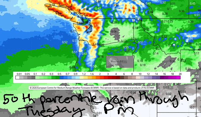
Good morning, neighbors! Junuary is about to make an appearance with sub-normal temps and some rain. Models are all over the place on rain amounts, but we’ll be keeping a very close eye on this as cherries are getting to the point where rain may impact them. Starting Friday, the free air freezing level (snow level as well) falls to 5500′ or less and stays there through (probably) Wednesday. Keep that in mind if you’re hiking or mountain biking or whatever else people do at higher elevations. (bumpin’ uglies?)
Glenwood and our international friends this morning
While that recap is exciting, this morning is sensible. Glenwood started the day at 44 degrees with sunshine. Looking around the world at our friends being threatened by the current US administration: Tehran is 86 degrees, sunny, with 22% humidity; Havana is 81F, partly cloudy, chance of thunder, and 82% humidity – MUGGY!; Muscat, Oman is 95 degrees, sunny, 59% humidity, and has a forecast low of 88F – brutally hot and muggy; finally, Caracas, Venezuela will be 78F, cloudy, and 81% humidity, also quite muggy.
Today’s Gorge weather forecast
Human family members in the Gorge will have some of the best weather in the world today (and no wars or violent cage matches). After a 45-55 degree start, we’ll end up perfectly pleasant. Hood River: 73F; The Dalles, 76F; Pasco, 81F. Morning clouds west of Mosier burn off by midday, and we’re all left sunny. West wind will be 15-20mph from Stevenson to Rufus by this afternoon with a chance at 20-25mph west of The Dalles. Overnight, keep your eyes on the northern horizon – the sun sent a package our way, and it’s possible it’ll explode into Aurora Borealis tonight!
Friday’s Gorge weather forecast
Low pressure (and cooler air) slowly moves towards us from Alaska on Friday. While clouds will increase especially west of the Cascade Crest, any associated moisture should stay west and north of Camas. Morning temps will be in the 40s to low 50s. Afternoon brings SIX-SEVEN degrees to Hod River, 72F to The Dalles, and 78F to Pasco. Afternoon cloud cover will be mostly cloudy to the west and partly high overcast east of Mosier. West wind starts at 15mph or so all the way from Stevenson to Arlington. Afternoon wind drops below 15mph west of Lyle and rises to 25-35mph from Lyle to Hermiston.
Extended Gorge weather forecast
Models get more aggressive about rain on Saturday as a weather system swings inland. We’ll have a cloudy start to the west of The Dalles and partly cloudy sky to the east with temps in the 40-50F range. Snow level: 4000! Afternoon brings temps ranging from 60F west of Hood river to 72F out in the desert. Rain is likely. Expect drizzle all day west of Viento with intermittent showers to Hood River through 5pm. Areas as far east as The Dalles could see a little drizzle (probably under 0.05”) prior to 11am. Early wind will be 5-10mph west of The Dalles and 15-25mph to the east. Afternoon: 15mph west of Lyle and 25-35mph to the east of Lyle.
A dry start Sunday gives way to a potentially stronger weather system Sunday night into Monday. We’ll be keeping a very close eye on this one as it has some potential to impact cherries. Intermittent rain is possible into Wednesday along with temps generally in the 65-75 degree rain. Rainbows will be numerous. Please protect yourself from their radical rainbow pro-trans agenda. A “radical pro-trans agenda” says that people should have access to medical care, official documents that match their gender identity, and general goodwill and safety from those around them. Rainbows are in support of this (It’s Pride Month, btw), and hopefully you are too! May we all be happy, safe, and cared for. Safe travels. -TATAS
HEY! DON’T STOP READING! Is this community-focused forecast helpful to you? It sure is! It takes me a couple hours a day to write. Please join your friends and neighbors in contributing to keep it going. Venmo: @thegorgeismygym PayPal: twomirrors@gmail.com USPS: Temira / PO Box 841 / Hood River, Oregon 97031 You can test out the forecast subscription for a few days for free by signing up below. Easy! Do it!
MT HOOD SNOW FORECAST

QR codes and links for end-of-season tips – thank you!!!
Cash/check: Temira – PO BOX 841 – Hood River, Oregon 97031


Leave a Reply