

GORGE WIND FORECAST
If you’re still seeing yesterday’s and it’s after 9am, try opening this in an incognito window
SHORT-TERM gorge wind forecast
Hi friends! Another fun day was had on the Nch’i Wana (Columbia River) yesterday. We settle into a much-needed rest day today. Easterlies pick up enough on Tuesday to get some of you on the river for a quick morning session, but the afternoon brings more time for resting. Stronger westerlies return on Wednesday, and some sort of west wind persists into Saturday, at least.
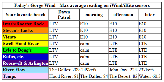
Monday started with pressures of 30.18/30.13/30.11 and light/variable wind. Easterlies pick up to 10mph at Stevenson, Iwash/Rooster Rock, Viento, and Home Valley late morning and persist into the afternoon. Elsewhere: calm or light east wind. River flow over the last 24 hours was 209-249kcfs (224-237 at Rufus), river temp is 60.3F, and high temp forecast is 81F and sunny.
RIVER FLOW FOR SITES BETWEEN AVERY (EAST OF THE DALLES) AND RUFUS: CLICK HERE FOR JOHN DAY DAM FLOW.
RIVER FLOW FOR SITES BETWEEN STEVENSON AND DOUG’S BEACH (WEST OF THE DALLES): CLICK HERE FOR THE DALLES DAM FLOW

LONGER-TERM gorge wind forecast
Tuesday starts with easterlies at 20-25mph at the usual east wind spots (maybe a bit less at Viento). You’ll get a few hours before the wind drops to 15mph. East of Viento, easterlies pick up to 10-15mph for a bit before fading in the afternoon. High temp: 84F and mostly sunny.
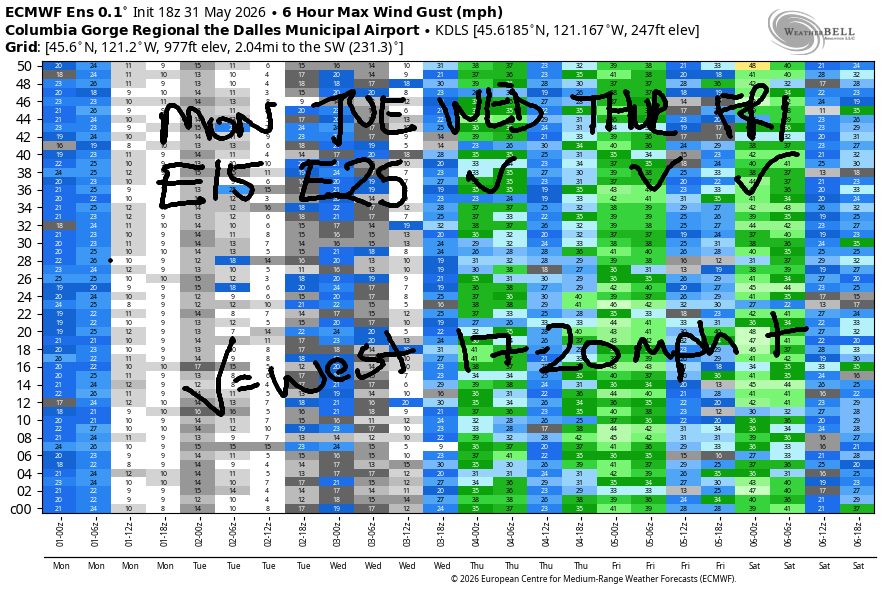
A system approaches on Wednesday and turns the wind westerly again. This isn’t an ideal setup – mid and high clouds combine with instability for a day that’s likely to be gusty, up-and-down, and rather unreliable. That said… expect 22-25mph early from Stevenson to Rufus. Areas west of Mosier are likely to be particularly gusty due to cloud cover. East of Mosier, midday wind rises to 17-31mph as far east as Rufus. In the afternoon and into the evening, we currently have a forecast of 29-33mph as offshore high pressure rebuilds and lends a helping hand. High temp: 76F in Hood River and 85F in the desert.
Another system approaches on Thursday for another gusty day. Call it 22-25mph strongest from Mosier to Doug’s. Friday is yet another not-ideal setup, but it does look to bring 30+ mph for areas east of The Dalles. The weekend forecast currently calls for 20-23mph both days. Looks like another decent week of wind. See you on the Nch’i Wana soon!

Was that helpful? I knew it was! Guess what? All of this crucial work – from your personal wind and snow reports to the invaluable TATAS updates – is made possible by my relentless efforts. Maintaining this labor of love isn’t easy. Each daily forecast takes hours. Website hosting, weather model access, and back-end admin work takes time and money. That’s where you come in.
YOUR CONTRIBUTION MAKES A DIFFERENCE
- SUPPORT ACCURATE, HYPER-LOCAL WEATHER FORECASTING
- ENABLE ACCESS FOR ALL, EVEN THOSE WITH LESS MEANS
- SUPPORT A COOL HUMAN WHO WORKS HARD SO YOU CAN PLAY
Take a moment to click one of the buttons below. Donate $19.99 or more (how much does this forecast enhance your life?) and get the email in your inbox. Whether it’s a renewing subscription (auto-renew) or a one-time donation, every contribution makes a real difference. Help me keep this labor of love alive, so we can all continue playing, commuting, and living in the Gorge with peace of mind and the best weather forecasts possible. Thank you!


Hood River, Oregon 97031


JONES BEACH, SAUVIE ISLAND, & COAST FORECAST
Wind northerly unless otherwise indicated. For coast, it’s North/Central/South with the “central” at approximately Florence. Swell forecast from NWS for central coast. Jones: westerly unless otherwise stated. Sauvie Island: northerly unless otherwise stated.
Coast Monday: 20/15-20/25-30, NW swell 4′ at 9 seconds. Tuesday: LTW/LTW/LTNW, W 3′ @ 12 and SW 2′ @ 18. Wednesday: LTW/LTW/N15-20, W 4′ @ 11 and SW 2′ @ 16. Jones Monday: LTW. Tuesday: LTW. Wednesday: 15-18. Sauvie Island Monday: 11-14. Tuesday: LTV. Wednesday: 10-13.
BARE BONES HOOD RIVER WEATHER FORECAST
Clear sky this morning with some high clouds later. Temps start in the mid 40s and rise to the low 80s. Light west wind early. Light east wind later. No rainbows. Tuesday will be mostly clear. Temps start in the mid 50s and rise to the mid 80s. Light easterlies. No rainbows. Wednesday will be partly to mostly cloudy. Temps start in the mid 50s and rise to the mid 70s. Moderately strong to strong westerlies. 1% chance of rainbows.
TEMIRA’S AWESOME TRAVEL ADVISORY SERVICE
HYPERLOCAL WEATHER FORECAST FOR THE COLUMBIA GORGE
THE DALLES, HOOD RIVER, WHITE SALMON, TROUT LAKE, STEVENSON, CASCADE LOCKS, PARKDALE, ODELL, HUSUM, BZ, MILL A, WILLARD, GOLDENDALE, RUFUS, ARLINGTON, boardman
Good morning, neighbors! Nothing exciting happens in the next few days – warm, mostly sunny weather is forecast Tuesday and Wednesday followed by cooler, breezier weather Wednesday through Friday. There’s some chance of rain west of Hood River this weekend, when temps will be 70 or less through the Gorge. For a period of time this weekend, temps at 5000′ will drop to 32-35F, allowing snow to fall above 5000′ or so. If the sky can clear on Saturday morning, Glenwood and Dufur will be at risk of frost.
All our friends, including Glenwood, this morning
But no frost nowhere not even a chance this morning. Even Glenwood is well above freezing at 37 degrees. Everyone is on the porch sipping coffee and listening to the birds singing at the sunrise. Other friends this morning: Tehran is expecting 86F today with a low of 65; Havana, Cuba, expects 82 degrees and clouds with high humidity; Muscat, Oman is 102 degrees today with enough humidity for a heat index of 106. Low temp there today: 92F. This does not seem like somewhere TATAS would enjoy living! Wishing all of those friends safety and comfort today!
Today’s Gorge weather forecast
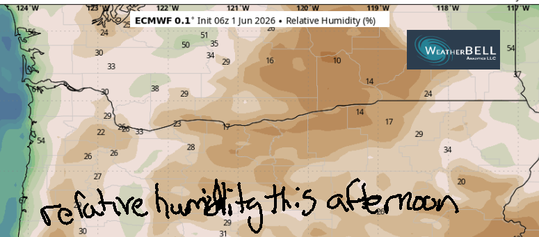
Here in the Gorge, we’re expecting a sunny and low-humidity day as the wind turns offshore. Temps rise to the low 80s all across the lowlands with 85F possible in The Dalles. Wind will be light westerly early, calm midday, and E 10mph west of Hood River in the afternoon. That is all.
Tuesday’s Gorge weather forecast
On Tuesday, decent overnight humidity recovery starts us off with 45-55 degrees under mostly clear sky. Afternoon weather will be 84-87 degrees in the lowlands with full-on sunshine. Expect low humidity, once again. East wind peaks at 20-25mph near Iwash (dick) Rock and between Stevenson and Viento in the morning before dropping to 10mph in the afternoon. Elsewhere, easterlies rise to 5-15mph mid-morning before turning light in the afternoon. Burning anything would be poor decision making. You. Are. Smarter. Than. That!
Extended Gorge weather forecast
A weather system approaches from the west on Wednesday and drags in clouds. Rain is unlikely except well north of the Nch’i Wana, where a few showers are possible but far from certain. What is certain is wind. Westerlies start at 20-25mph and build to 25-35mph in the afternoon all the way from Stevenson to Hermiston. Highs range from 73F in Stevenson to 76F in Hood River to 80F in The Dalles and 85F in the desert. Cool, breezy weather continues Thursday and Friday.
Next weekend looks cool. There’s a chance of some rain west of Hood River, but no promises. Saturday looks impressively cool: just 60 degrees for a high temp! After next weekend, models hint at some sort of warming trend, but the amplitude of the heat is unclear: by the following weekend, high temp forecasts range from 75 to 95 degrees, which really isn’t much of a forecast at all! Safe travels! -TATAS
HEY! DON’T STOP READING! Is this community-focused forecast helpful to you? It sure is! It takes me a couple hours a day to write. Please join your friends and neighbors in contributing to keep it going. Venmo: @thegorgeismygym PayPal: twomirrors@gmail.com USPS: Temira / PO Box 841 / Hood River, Oregon 97031 You can test out the forecast subscription for a few days for free by signing up below. Easy! Do it!
MT HOOD SNOW FORECAST

QR codes and links for end-of-season tips – thank you!!!
Cash/check: Temira – PO BOX 841 – Hood River, Oregon 97031


Leave a Reply