

GORGE WIND FORECAST
If you’re still seeing yesterday’s and it’s after 9am, try opening this in an incognito window
SHORT-TERM gorge wind forecast
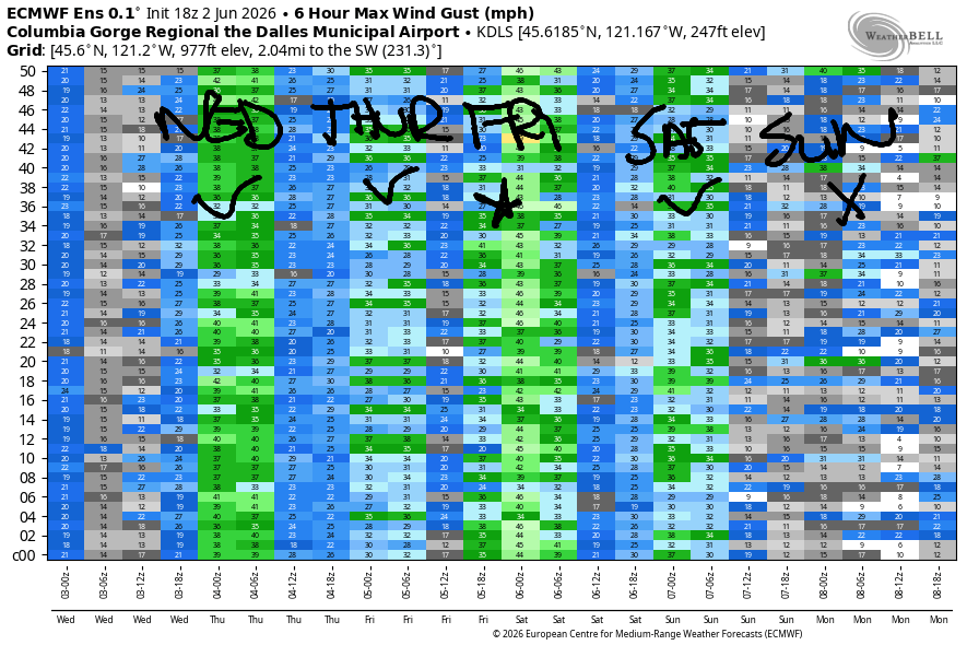
Hi friends! Lots of moving pieces in the forecast for the next week or so as a series of spring weather systems impacts the Pacific Northwest. Westerlies of some sort stick around through Saturday with the strongest day in this stretch likely to be Friday. Models hint at a rest day from windsports on Monday and perhaps Tuesday with hints of stronger wind (but lots of uncertainty) returning next Tuesday.
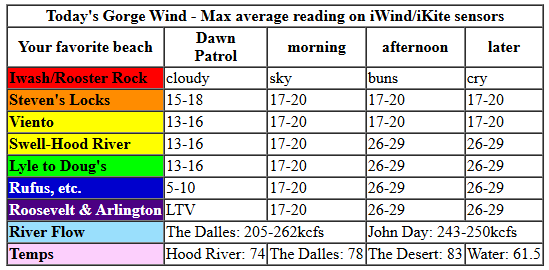
Looking at today, Wednesday, we started with pressures of 30.05/29.95/29.97 for gradients of 0.10/-0.02. A warm front is moving through the area, and that’ll be followed by a cold front later. All these moving pieces are not ideal. We start with westerlies in the 13-16mph range from Stevenson to Doug’s with light/variable wind farther east. As the cold front moves inland mid to late afternoon, gusty westerlies build.
After 2pm, we’re looking at 26-29mph from Mosier to Arlington, strongest from Doug’s to Rufus. Between Stevenson and Hood River, we’ll have gusty 16-19mph. Just prior to the cold front, and also after it clears the area, we’re likely to see a short-lived spike of stronger, gusty wind at the Hatch. Timing that? Uncertain. River flow over the last 24 hours was 205-262kcfs, river temp is 61.5F, and high temp forecast is 74F for Hood River and 80ish in the desert. Rufus current: 243-250kcfs.
RIVER FLOW FOR SITES BETWEEN AVERY (EAST OF THE DALLES) AND RUFUS: CLICK HERE FOR JOHN DAY DAM FLOW.
RIVER FLOW FOR SITES BETWEEN STEVENSON AND DOUG’S BEACH (WEST OF THE DALLES): CLICK HERE FOR THE DALLES DAM FLOW

LONGER-TERM gorge wind forecast
Thursday starts with low clouds to the west and clear sky to the east with 10-13mph all the way from Stevenson to Arlington. The wind slowly builds to 17-20mph from Stevenson to Arlington mid to late morning. Afternoon sees areas east of The Dalles drops to 15mph while Stevenson-Doug’s holds at 17-20mph. 20-23mph is possible from Viento to Doug’s late in the day. High temp: 74-81F.
Friday sees another approaching weather system. The day starts with 15-18mph from Stevenson to Threemile. Afternoon wind builds to 27-31mph from Lyle to Rufus with 25-28mph east of Rufus to Hermiston. Areas west of Lyle will be cloudy and quite gusty and likely under 15mph. High temps: 67-79F.
Models currently call for 22-25mph on Saturday, but atmospheric instability may impact that. As of this morning, we’re looking at a light wind day Sunday and probably Monday. Uncertainty is quite high beyond that, but models do hint at stronger westerlies returning next Tuesday. I’ll leave you there for now. See you on the Nch’i Wana soon!

Was that helpful? I knew it was! Guess what? All of this crucial work – from your personal wind and snow reports to the invaluable TATAS updates – is made possible by my relentless efforts. Maintaining this labor of love isn’t easy. Each daily forecast takes hours. Website hosting, weather model access, and back-end admin work takes time and money. That’s where you come in.
YOUR CONTRIBUTION MAKES A DIFFERENCE
- SUPPORT ACCURATE, HYPER-LOCAL WEATHER FORECASTING
- ENABLE ACCESS FOR ALL, EVEN THOSE WITH LESS MEANS
- SUPPORT A COOL HUMAN WHO WORKS HARD SO YOU CAN PLAY
Take a moment to click one of the buttons below. Donate $19.99 or more (how much does this forecast enhance your life?) and get the email in your inbox. Whether it’s a renewing subscription (auto-renew) or a one-time donation, every contribution makes a real difference. Help me keep this labor of love alive, so we can all continue playing, commuting, and living in the Gorge with peace of mind and the best weather forecasts possible. Thank you!


Hood River, Oregon 97031


JONES BEACH, SAUVIE ISLAND, & COAST FORECAST
Wind northerly unless otherwise indicated. For coast, it’s North/Central/South with the “central” at approximately Florence. Swell forecast from NWS for central coast. Jones: westerly unless otherwise stated. Sauvie Island: northerly unless otherwise stated.
Coast Wednesday: LTW/LTW/N15-20, W swell 6′ at 11 seconds and SW 2′ @ 15 seconds. Thursday: LTNW/N10-15/30-35, W 5′ @ 10 and SW 2′ @ 16. Friday: W10/LTW/N20, SW 2′ @ 18 and W 6′ @ 12.
BARE BONES HOOD RIVER WEATHER FORECAST
Cloudy with a little drizzle this morning and partly cloudy this afternoon. Temps start in the upper 60s (no record, sad) and finish in the mid 70s. Moderate westerlies. 1% chance of rainbows. Thursday will be mostly cloudy then mostly clear. Temps start in the low 50s and rise to the mid 70s. Light westerlies early. Moderate westerlies later. No rainbows. Friday will be partly cloudy then cloudier with a chance of rain overnight. Temps start in the upper 40s and rise to the upper 60s. Moderate westerlies. No rainbows.
TEMIRA’S AWESOME TRAVEL ADVISORY SERVICE
HYPERLOCAL WEATHER FORECAST FOR THE COLUMBIA GORGE
THE DALLES, HOOD RIVER, WHITE SALMON, TROUT LAKE, STEVENSON, CASCADE LOCKS, PARKDALE, ODELL, HUSUM, BZ, MILL A, WILLARD, GOLDENDALE, RUFUS, ARLINGTON, boardman
Good morning, neighbors! It’s a cloudy start to the day here in the Gorge, and we even picked up a little drizzle. That’s not the last of the rain – the bulk arrives on Friday night. Quantities and locations are not certain yet, but we’ll definitely be keeping an eye on this for impacts on cherries. Other than that… generally cool weather (under 80F) through the weekend.
Glenwood and other friends around the world this morning
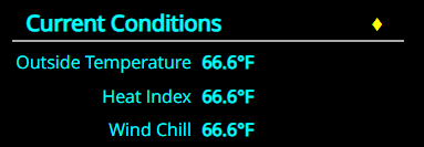
Wednesday started off quite warm – 66.6 degrees in Hood River (probably a bad omen) and 52F in Glenwood. Other friends around the world are expecting… 86 degrees and 21% humidity in Tehran; 83F and 76% humidity in Havana; 98 degrees and 44% humidity in Muscat, Oman, where the low today will be 90F; and 76 degrees and 69% humidity in Caracas, Venezuela. Elsewhere locally: just plain WARM this morning with lows from 55 to 70 degrees.
Today’s Gorge weather forecast
A little drizzle is possible this morning as far east as Avery, but it may not reach the ground – rain is likelier the higher up you go. Clearing arrives this afternoon with temps ranging from 74F (Hood River) to 78F (The Dalles) and 83F (Pasco). West wind picks up to 15-20mph west of Mosier and 25-30mph from Mosier to the Arlington Triangle.
Thursday’s Gorge weather forecast
Overnight, we may see a little drizzle west of Cascade Locks. Thursday morning starts with low clouds west of Mosier and clear sky to the east with temps in the 40-55F range. West wind will be 10-15mph all through the Gorge to start the day. Afternoon wind rises to 15-20mph from Stevenson to Arlington. Temps max out between 74F (west) to 81F (desert).
Extended Gorge weather forecast
Another weather system is forecast Friday evening. We start the day at 40-50 degrees with partly to mostly cloudy sky and west wind at 15-20mph. Afternoon looks cloudy, windy (25-30mph) and 67F (Hood River) to 79F (Pasco). Rain is likely overnight. Its unclear how far east ti will extend; as of now, models hint at rain as far east as The Dalles, but they’re also all over the map in terms of how much rain we get. Cool weather (64-72F) is forecast Saturday with showers west of Hood river. Sunday looks warmer (75F or so). It’s possible we could see significant rain on Monday, but models do not yet agree on that. I’ll leave it there for now – running late this morning. Safe travels. -TATAS
HEY! DON’T STOP READING! Is this community-focused forecast helpful to you? It sure is! It takes me a couple hours a day to write. Please join your friends and neighbors in contributing to keep it going. Venmo: @thegorgeismygym PayPal: twomirrors@gmail.com USPS: Temira / PO Box 841 / Hood River, Oregon 97031 You can test out the forecast subscription for a few days for free by signing up below. Easy! Do it!
MT HOOD SNOW FORECAST

QR codes and links for end-of-season tips – thank you!!!
Cash/check: Temira – PO BOX 841 – Hood River, Oregon 97031


Leave a Reply