

GORGE WIND FORECAST
If you’re still seeing yesterday’s and it’s after 9am, try opening this in an incognito window
SHORT-TERM gorge wind forecast
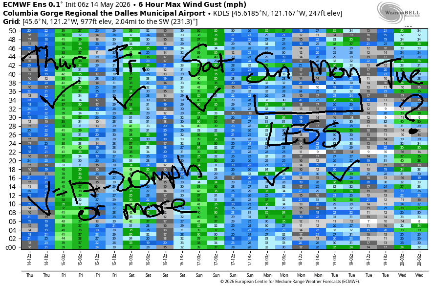
Hi friends! The far, far east was the place to be yesterday with Threemile and Boardman taking the prizes for the strongest wind. Moderately strong to strong westerlies continues through Saturday followed by somewhat lesser westerlies Sunday and Monday. Before I forget… the bathtub is really full right now; the water level is high. As a result, there is a lot of debris in the river, or at least there is near the Hatchery and probably all through the pool below The Dalles Dam (not sure about the other lakes). Be careful out there!
Thursday started with pressures of 30.20/30.15/30.11 for gradients of 0.05/0.04. Offshore: 30.36. Once again, we have moving parts to the setup, which isn’t ideal – a trough and front are forecast to move inland. Result: another round of up-and-down westerlies. Early wind was 15-18mph from Viento to Hood River and the same from Arlington to Boardman. Other locations were generally under 10-15mph. We’ll see a slow build as the desert warms.
By early afternoon, you’ll find gusty 16-19mph from Stevenson to Mosier with gusty 20-24mph from Mosier to Arlington. Later wind, aided by cool air pushing in to the west side, rises to gusty 25-28mph from Lyle to Threemile with continued upper teens west of Hood River. River flow over the last 24 hours was 196-238kcfs (2234-238 at Rufus), river temp is 57.7F, and high temp forecast is 66F in Hood River and 73F out east.
RIVER FLOW FOR SITES BETWEEN AVERY (EAST OF THE DALLES) AND RUFUS: CLICK HERE FOR JOHN DAY DAM FLOW.
RIVER FLOW FOR SITES BETWEEN STEVENSON AND DOUG’S BEACH (WEST OF THE DALLES): CLICK HERE FOR THE DALLES DAM FLOW

LONGER-TERM gorge wind forecast
Another round of “moving parts” is forecast on Friday. We’ll start with less than 10mph west of The Dalles and 15-18mph from Avery to Boardman. As a system pushes inland and adds some mid-level clouds to the mix, we’ll see the wind build: gusty 13-16mph from Stevenson to Hood River with, eventually, gusty 25-28mph from Mosier to Boardman. The far east folks are having a great time of it lately! High temps range from 62F in Hood River to 70F out in the desert.
Cool air slides inland on Saturday and triggers instability. Somewhat balancing that is a weak heat low in WA and strong to very strong offshore high pressure with lingering clouds on the west side of the Cascades. Early wind will be light west of The Dalles with 25-28mph between Avery and Arlington. The GFS wants to give us 30+ in the desert Saturday afternoon. The Euro is slightly less optimistic. Complicating the picture is surface-based instability and a chance of thunderstorms; this tends to impact wind quality and reliability. So, we’ll have wind, but it might not be the best wind. High temps range from 57F in Hood River to 65F in the desert.
Somewhat lesser westerlies are forecast Sunday and Monday, perhaps upper teens to low 20s. Beyond that, model uncertainty is too high to make any predictions. Not a bad stretch of wind for this time of year! Hope to see you on the Nch’i Wana soon!

Was that helpful? I knew it was! Guess what? All of this crucial work – from your personal wind and snow reports to the invaluable TATAS updates – is made possible by my relentless efforts. Maintaining this labor of love isn’t easy. Each daily forecast takes hours. Website hosting, weather model access, and back-end admin work takes time and money. That’s where you come in.
YOUR CONTRIBUTION MAKES A DIFFERENCE
- SUPPORT ACCURATE, HYPER-LOCAL WEATHER FORECASTING
- ENABLE ACCESS FOR ALL, EVEN THOSE WITH LESS MEANS
- SUPPORT A COOL HUMAN WHO WORKS HARD SO YOU CAN PLAY
Take a moment to click one of the buttons below. Donate $19.99 or more (how much does this forecast enhance your life?) and get the email in your inbox. Whether it’s a renewing subscription (auto-renew) or a one-time donation, every contribution makes a real difference. Help me keep this labor of love alive, so we can all continue playing, commuting, and living in the Gorge with peace of mind and the best weather forecasts possible. Thank you!


Hood River, Oregon 97031


JONES BEACH, SAUVIE ISLAND, & COAST FORECAST
Wind northerly unless otherwise indicated. For coast, it’s North/Central/South with the “central” at approximately Florence. Swell forecast from NWS for central coast. Jones: westerly unless otherwise stated. Sauvie Island: northerly unless otherwise stated. Coast Thursday: SW10/W5-1-0/N25-30, W swell 6′ @ 10 seconds. Friday: WSW20-25/W15-20/N20-25, W 7′ @ 9. Saturday: NW15-20/NW15/N25-35, W 10′ @ 13. Jones Thursday: LTW. Friday: 7-10. Saturday: 13-16. Sauvie Island Thursday: NW 11-14. Friday: SW 10. Saturday: NW 15-18.
BARE BONES HOOD RIVER WEATHER FORECAST
Drizzle this morning. Partly cloudy this afternoon. Temps start in the low 50s and rise to the mid 60s. Moderate westerlies. 98% chance of rainbows. Friday will be drizzly early, dry midday, and drizzly in the evening. Temps start in the mid 40s and rise to the low 60s. Moderate westerlies. 71% chance of rainbows. Saturday will be cloudy and showery early and partly cloudy later with thunderstorms possible in the afternoon. Temps start in the low 40s and rise to the upper 50s. Light westerlies early. Moderate later. 70% chance of rainbows.
TEMIRA’S AWESOME TRAVEL ADVISORY SERVICE
HYPERLOCAL WEATHER FORECAST FOR THE COLUMBIA GORGE
THE DALLES, HOOD RIVER, WHITE SALMON, TROUT LAKE, STEVENSON, CASCADE LOCKS, PARKDALE, ODELL, HUSUM, BZ, MILL A, WILLARD, GOLDENDALE, RUFUS, ARLINGTON, boardman
Good morning, neighbors! It’s a chilly, drizzly morning for many, and there’s a trace of new snow on the local volcanoes. Sounds funny when I say it that way, doesn’t it? “Local volcano!” Unseasonably cool weather – normal is 65-70 – interspersed with drizzle continues for a few days before we probably ride the temp elevator upwards for the first half of next week. Along with this chilly weather comes a chance of frost – a slight chance on Friday morning and a much better chance on Sunday morning.
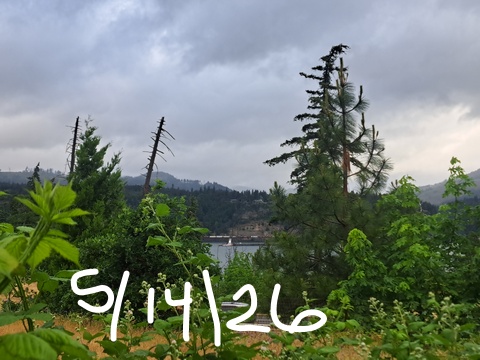
Glenwood this morning and today’s Gorge weather forecast
Thursday starts with intermittent drizzle to The Dalles for the morning with drizzle continuing on-and-off into the evening as far east as Cascade Locks. Glenwood started the day at 48 degrees – nothing interesting ever happens there when it’s cloudy. At least 48 is divisible by 3 which makes it cool. You know it’s divisible by 3 because 4 + 8 = 12 which is divisible by 3. You’re welcome! By afternoon, temps rise to the mid 60s west of Mosier, 70 degrees in The Dalles, and low 70s out in the desert with partly cloudy sky all through the Gorge. West wind picks up to 15-20mph west of Mosier and 25-30mph from Mosier east to Threemile Canyon which is nine miles east of the three-sided Arlington Triangle and many, many miles from the nearest three-colored stoplight.
Friday’s Gorge weather forecast
Overnight into Friday morning, we’ll have clouds to the west and partly cloudy sky to the east. The free air freezing level will be around 2500′, and temps at 850mb will be around -1C. Fortunately, models do keep the sky cloudy with light drizzle in the wee hours of the morning as far east as The Dalles. This should protect all the growing areas from frost or sub-freezing temps. If there’s unexpected clearing overnight, we could see temps fall below 36F in Dufur, Trout Lake, Glenwood, Goldendale (unless it’s windy there), and the Upper Valley. That’s a low-probability scenario. Lowland locations start the day in the mid 40s.
Morning wind will be less than 10mph west of The Dalles and 15-20mph to the east. Afternoon wind rises to 15mph west of Mosier and 25-30mph from Mosier to Boardman. Highs range from 62F in Hood River to 70F out in the desert. Another round of light drizzle is likely overnight all the way east to Celilo Village and south into south Wasco, Sherman, and Gilliam Counties. Snow level: 4000′.
Saturday’s Gorge weather forecast
Another system moves in on Saturday and triggers atmospheric instability. We’ll start with intermittent morning showers, turn partly cloudy midday, and move into a thunderstorm-possible setup in the afternoon and evening. Another chilly start is expected, but so are clouds, sprinkles, and wind, so we’re unlikely to see frost except perhaps in Glenwood if it’s clear there. Wind will be 5-10mph west of Avery in the morning with 25-30mph from Avery to Boardman. Afternoon wind rises to 15-20mph west of Lyle and 25-35mph from Lyle to Boardman. Highs will be well below normal with upper 50s west of Rowena, 60ish near The Dalles, and mid 60s in the desert.
Extended Gorge weather forecast
Clearing sky, cold temps aloft (0C at 850mb), and light wind combine for possible frost on Sunday morning. We’ll keep a close eye on this. It’s possible that Trout Lake, the Parkdale area, Dufur, and the east side of The Dalles could see temps fall below 36F. Afternoon brings sunshine and temps from 63-69F with 20mph west wind. We’re out of the danger zone by Monday morning (except in Glenwood), as temps aloft rise to 5C, sunshine returns, and highs climb to 70-75F. Generally speaking, we should see a few days of warming weather, but the details are unclear. For what it’s worth, I’m planting my peppers and basil on Monday. Safe travels. -TATAS
HEY! DON’T STOP READING! Is this community-focused forecast helpful to you? It sure is! It takes me a couple hours a day to write. Please join your friends and neighbors in contributing to keep it going. Venmo: @thegorgeismygym PayPal: twomirrors@gmail.com USPS: Temira / PO Box 841 / Hood River, Oregon 97031 You can test out the forecast subscription for a few days for free by signing up below. Easy! Do it!
MT HOOD SNOW FORECAST

QR codes and links for end-of-season tips – thank you!!!
Cash/check: Temira – PO BOX 841 – Hood River, Oregon 97031


