

GORGE WIND FORECAST
If you’re still seeing yesterday’s and it’s after 9am, try opening this in an incognito window
SHORT-TERM gorge wind forecast
Hi friends! Sounds like the Rufus area served up the goods for many of you yesterday! Today, and for the next few days, we’ll have an opportunity to drive less – westerlies will be focused in the Corridor with lingering opportunities to spend some time at Rufus. Temps will be on the rise too, which I’m sure many of you will appreciate after yesterday’s chill!
Sunday started with pressures of 30.25/30.16/30.11 with clouds in the hole and sun to the east. Offshore: 1032mb. Strong! Before you get on the river, head on over to Windance for the first swap meet of the season. Mark your calendars for June 21, July 19, and August 23 for the rest of those swaps. CGW2’s season opener swap meet is May 24th at Lot 1 on the Hood River waterfront. Rest of their dates: July 5, September 6. Back to the forecast: models have at least some marine layer sticking around today west of Hood River as a shortwave ridge moves inland. Offshore: strong high pressure.
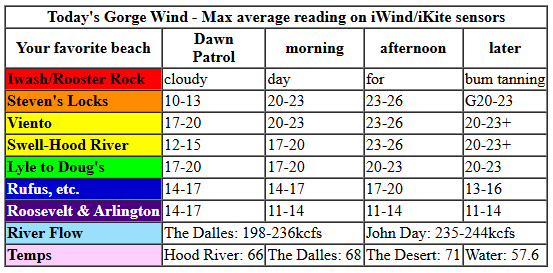
Early wind was 10-13mph all through the Gorge, likely dampened by cool temps. By late morning, we’ll have 23-26mph from Stevenson to Hood River with 17-20 near Rowena and less near Rufus. Afternoon wind fills in from Stevenson to Doug’s at 23-26mph with 20-23mph at Avery and 14-17mph at Rufus. If the low clouds really hang in there today on the west side, we could see Stevenson-Mosier exceed expectations. River flow over the last 24 hours was 198-244kcfs (235-244kcfs at Rufus), river temp is 57.6F, and high temp forecast is 66F in Hood River and 71F in the desert.
RIVER FLOW FOR SITES BETWEEN AVERY (EAST OF THE DALLES) AND RUFUS: CLICK HERE FOR JOHN DAY DAM FLOW.
RIVER FLOW FOR SITES BETWEEN STEVENSON AND DOUG’S BEACH (WEST OF THE DALLES): CLICK HERE FOR THE DALLES DAM FLOW

LONGER-TERM gorge wind forecast
Offshore high pressure continues on Monday, and a low pressure system approaches British Columbia, home of Cheezies, Coffee Crisp, and universal healthcare. Early wind will be 17-20mph from Viento to Mosier with light wind in cloudy Stevenson and 11-14mph near Rowena. In the desert, the wind starts under 10mph. By late morning, westerlies rise to gusty 20-23mph from Stevenson to Doug’s or Avery with 11-14mph at Rufus. Clouds eventually dissipate on the west side, but not before the desert gets a jump on the heating. This allows for gusty 21-25 from Stevenson to Rufus with a decent shot at gusty 24-28 from Mosier to Doug’s. Arlington and Threemile eventually, probably after 5pm, build to 20-23mph or a bit more. High temp: 71F in Hood River and 75F in the desert.
Light wind starts your Tuesday – just 11-14mph from Viento to the Hatch with 5-10mph in Stevenson and also from Hood River to Arlington. A weak system moves through in the morning and nudges the wind up to gusty 18-21mph from Stevenson to Mosier with 12-15mph near Rowena. Afternoon wind rises to 22-25mph from Stevenson to Viento, gusty 17-21mph at the Hatch, and 22-25mph from Stevenson to Rufus. Hold out a bit longer, and you should get 26-29mph from Stevenson to Arlington, strongest from Rowena to Rufus. High temps range from 71F to 77F.
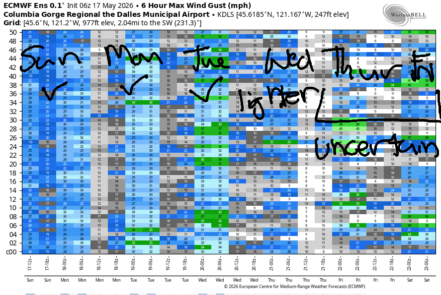
Looking at the longer-range forecast… models suggest lighter wind on Wednesday, perhaps 16-19mph focused on the Corridor. Uncertainty jumps on Thursday with models calling for anything from light wind to upper 20s. Uncertainty lingers in the forecast into the deeper future. That said, models generally indicate westerlies of some sort with very low potential for zero-wind days. Looks like May is going to deliver! Yay! See you on the Nch’i Wana soon!

Was that helpful? I knew it was! Guess what? All of this crucial work – from your personal wind and snow reports to the invaluable TATAS updates – is made possible by my relentless efforts. Maintaining this labor of love isn’t easy. Each daily forecast takes hours. Website hosting, weather model access, and back-end admin work takes time and money. That’s where you come in.
YOUR CONTRIBUTION MAKES A DIFFERENCE
- SUPPORT ACCURATE, HYPER-LOCAL WEATHER FORECASTING
- ENABLE ACCESS FOR ALL, EVEN THOSE WITH LESS MEANS
- SUPPORT A COOL HUMAN WHO WORKS HARD SO YOU CAN PLAY
Take a moment to click one of the buttons below. Donate $19.99 or more (how much does this forecast enhance your life?) and get the email in your inbox. Whether it’s a renewing subscription (auto-renew) or a one-time donation, every contribution makes a real difference. Help me keep this labor of love alive, so we can all continue playing, commuting, and living in the Gorge with peace of mind and the best weather forecasts possible. Thank you!


Hood River, Oregon 97031


JONES BEACH, SAUVIE ISLAND, & COAST FORECAST
Wind northerly unless otherwise indicated. For coast, it’s North/Central/South with the “central” at approximately Florence. Swell forecast from NWS for central coast. Jones: westerly unless otherwise stated. Sauvie Island: northerly unless otherwise stated. Coast Sunday: 15-20/20-25/nuking, NW swell 8′ @ 11 seconds. Monday: 10-15/15-20/30-40, NW 8′ @ 16. Tuesday: 10-15/15-20/25-35, NW 7′ @ 14. Jones Sunday: 16-19. Monday: 16-19. Tuesday: 10-13. Sauvie Island Sunday: 13-16. Monday: 11-14. Tuesday: 7-10.
BARE BONES HOOD RIVER WEATHER FORECAST
Clear sky today. Temps start in the low 40s and rise to the mid 60s. Moderately strong westerlies. No rainbows. Monday will be cloudy then clear. Temps start in the low 40s and rise to the low 70s. Moderately strong westerlies. No rainbows. Tuesday will be mostly clear. Temps start in the low 40s and rise to the low 70s. Light westerlies early. Strong later. No rainbows.
TEMIRA’S AWESOME TRAVEL ADVISORY SERVICE
HYPERLOCAL WEATHER FORECAST FOR THE COLUMBIA GORGE
THE DALLES, HOOD RIVER, WHITE SALMON, TROUT LAKE, STEVENSON, CASCADE LOCKS, PARKDALE, ODELL, HUSUM, BZ, MILL A, WILLARD, GOLDENDALE, RUFUS, ARLINGTON, boardman
Good morning, neighbors! Brrrr…. it’s chilly out there this morning. Thankfully, this is the last of the worst of the chill for hopefully the rest of the warm season. A warming trend lingers through at least the mid to latter half of the upcoming week. Dry weather is likely all the way through next week with a slight chance of rain next week or perhaps next week – chances are pretty low. You’ll be hard-pressed to find a no-wind day in the next couple of weeks. Best chance for light wind looks like this morning, Tuesday morning or potentially early Wednesday.
Gorge morning weather roundup
Looking around the region this morning, we had a few areas that dropped into the 32-36F range this morning. I’m not sure if the chill lasted long enough for frost (which can happen at 36F and below due to radiational cooling). Parkdale stations were reading 34-37F this morning, Trout Lake was 33F, Goldendale 31-36F, Dufur 30F, and Glenwood… wasn’t reporting, sadly, because it’s just the kind of morning when Glenwood would take the prize! Up in the mountains… Timberline is reporting 13” of new snow and 23 degrees, and there’s about 8” on the snow stake at the base of Meadows. Oh do the volcanoes look pretty this morning all dressed up in white!
For the rest of today… we start with low clouds to the west and sunshine to the east. As a weak system moves inland, a few little fluffy mid-level clouds pop up in the afternoon. The wind started pretty light – under 10mph everywhere. It’ll build to 25mph from Stevenson to Avery this afternoon with 15-20mph between the mouth of the Deschutes and the Arlington Triangle. Highs range from 61F (Cascade Locks) to 66F (Hood River) and 68F (The Dalles). Father east: low 70s.
Monday’s Gorge weather forecast
Monday starts with low and mid-level clouds west of Mosier and high clouds to the east. Afternoon: mostly clear. We’re likely to have a spectacular sunrise somewhere around here with that setup. Temps range form 37F-45F to start the day. By afternoon, we’ll have 65F in the western Gorge, 71F in Hood River, and 73F in The Dalles with mid-70s farther east. Wind: 15-20mph from Viento to Mosier in the morning with 10mph or less elsewhere. Afternoon wind builds to 20-30mph from Stevenson to Rufus and 20-25mph near Arlington’s well-groomed Triangle.
Tuesday’s Gorge weather forecast
Tuesday’s weather won’t be so different than Monday. We start partly cloudy in the west with a few high clouds to the east and temps from 37-45F. Wind will be light to start: 10-15mph from Viento to Hood River with under 10mph elsewhere. Spray, baby, spray! Afternoon wind rises to 25-30mph from Stevenson to Rufus with 20-25mph near the Arlington Triangle. Temps max out in the mid 60s in Stevenson, 70 degrees near Hood River, and 75 degrees in The Dalles.
Wednesday’s Gorge weather forecast
We’ll pick up a few more degrees of warmth on Wednesday – The Dalles maxes out right around 80. Wind will be down to 15-20mph. Uncertainty increases on Thursday as the high temp range widens. While there’s some indication of a minor cooling trend into the start of the following week, the range of possible high temps is large, and details are unclear. As I mentioned earlier, there is a slight chance of some drizzle late in the weekend, but it’s far from certain – only about 30% of the Euro ensemble is on board with rain for Cascade Locks, and there’s even less chance farther east.
Valuable Advice for Gardeners Inhabiting Neighboring Areas
Now, let’s talk about what’s really important – my garden. And yours. Unless a drastic shift happens in the forecast models, everyone below 1000′ is probably going to be frost-free from now through the summer. There are a few days where Glenwood may still see a frost, and the Parkdale area will flirt with 36F the next couple of mornings. I’m going to go ahead and plant pretty much everything – I discovered a couple tomatillo volunteers yesterday, which tells me my soil is warm enough to plant anything I want. Ditto with the 8” tall sunflower volunteers. Happy gardening. Safe travels. -TATAS
HEY! DON’T STOP READING! Is this community-focused forecast helpful to you? It sure is! It takes me a couple hours a day to write. Please join your friends and neighbors in contributing to keep it going. Venmo: @thegorgeismygym PayPal: twomirrors@gmail.com USPS: Temira / PO Box 841 / Hood River, Oregon 97031 You can test out the forecast subscription for a few days for free by signing up below. Easy! Do it!
MT HOOD SNOW FORECAST

QR codes and links for end-of-season tips – thank you!!!
Cash/check: Temira – PO BOX 841 – Hood River, Oregon 97031


Hey skiers and snowboarders! Thank you so much for using this forecast all winter. I’m betting all of us wished for more snow. Hopefully this forecast helped you make the most of the snow we received. If it was helpful, please consider making an end-of-season tip to support me and all the work I put in to making your life more fun!
If you don’t use electronic payments, you can send cash or check to: Temira / PO Box 841 / Hood River, Oregon 97031
THANK YOU FOR YOUR SUPPORT!!! HAVE A GREAT SUMMER!!!
