

GORGE WIND FORECAST
If you’re still seeing yesterday’s and it’s after 9am, try opening this in an incognito window
SHORT-TERM gorge wind forecast
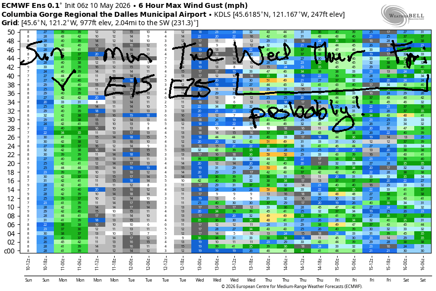
Hi friends! It’s Sunday morning, and Dawn Patrol isn’t cooperating with the gradients or yesterday’s Dawn Patrol forecast. That’s okay – it’ll still be windy today. Get it while you can. Easterlies take over Monday and Tuesday as high pressure builds over the region and heats us all up. Models are struggling to resolve the next pattern change; it happens Wednesday or Thursday, and the deets of “how” aren’t clear either. That said, we’re likely to see a return to relatively strong, rather gusty west wind by Thursday at the latest.
Sunday morning started with pressures of 30.05/29.97/29.97 for gradients of 0.08/0.00. Offshore: 30.17 for a little more support. Today’s moving piece is a shortwave trough moving inland late morning. Since dawn patrol deigned to cooperate, you’ll be looking east this afternoon for the strongest wind. That said… morning wind should build to 22-25mph from Stevenson to Avery.
Afternoon: Hatch is likely to drop to gusty 17-21mph in response to the atmospheric shenanigans; Stevenson and Viento should hold in the 22-25mph range. From Mosier to Rufus early afternoon, we’ll see gusty 27-30mph. From Mosier to Threemile mid-afternoon, westerlies rise to 28-32mph and hopefully steady out some as the system clears the eastern Gorge. River flow over the last 24 hours was 211-240kcfs (224-240 at Rufus), river temp is 57.4F, and high temp forecasts range from 73F in Hood River to 84F in Pasco.
RIVER FLOW FOR SITES BETWEEN AVERY (EAST OF THE DALLES) AND RUFUS: CLICK HERE FOR JOHN DAY DAM FLOW.
RIVER FLOW FOR SITES BETWEEN STEVENSON AND DOUG’S BEACH (WEST OF THE DALLES): CLICK HERE FOR THE DALLES DAM FLOW

LONGER-TERM gorge wind forecast
High pressure builds inland on Monday. In response, the day starts perfectly calm and perfectly perfect for whatever you like to do when there’s zero wind. Easterlies rise to 15mph at Stevenson and 10mph at Iwash/Rooster Rock mid-morning, hold for a few hours, and end the day at 10mph. High temp: 80F.
Thanks to a heat low on the west side, Tuesday starts with stronger easterlies: 25mph at both Iwash and Stevenson. Afternoon wind fades to 10-15mph at Iwash and 10mph at Stevenson. High temp: 86F.
As I mentioned earlier, there’s quite a bit of uncertainty about Wednesday; we can clearly see this in the high temp forecast for The Dalles which ranges from 62F to 81F. Many members of the Euro ensemble call for nuking westerlies; the GFS deterministic is not so enthusiastic. Worst case scenario is likely to bring us at least some west wind in the Corridor Wednesday evening. Better agreement is found in the forecast for Thursday when models agree on relatively strong west wind. Same for Friday. Hope to see you on the Nch’i Wana today!

Was that helpful? I knew it was! Guess what? All of this crucial work – from your personal wind and snow reports to the invaluable TATAS updates – is made possible by my relentless efforts. Maintaining this labor of love isn’t easy. Each daily forecast takes hours. Website hosting, weather model access, and back-end admin work takes time and money. That’s where you come in.
YOUR CONTRIBUTION MAKES A DIFFERENCE
- SUPPORT ACCURATE, HYPER-LOCAL WEATHER FORECASTING
- ENABLE ACCESS FOR ALL, EVEN THOSE WITH LESS MEANS
- SUPPORT A COOL HUMAN WHO WORKS HARD SO YOU CAN PLAY
Take a moment to click one of the buttons below. Donate $19.99 or more (how much does this forecast enhance your life?) and get the email in your inbox. Whether it’s a renewing subscription (auto-renew) or a one-time donation, every contribution makes a real difference. Help me keep this labor of love alive, so we can all continue playing, commuting, and living in the Gorge with peace of mind and the best weather forecasts possible. Thank you!


Hood River, Oregon 97031


BARE BONES HOOD RIVER WEATHER FORECAST
Mostly cloudy this morning. Mostly clear later. Temps start in the upper 40s and rise to the low 70s. Moderately strong westerlies after a light wind start. No rainbows. Monday will be mostly clear. Temps start in the mid 40s and rise to 80. Calm wind early. Light easterlies later. No rainbows. Tuesday will be partly high cloudy. Temps start in the low 50s and rise to the mid 80s. Light easterlies. No rainbows.
TEMIRA’S AWESOME TRAVEL ADVISORY SERVICE
HYPERLOCAL WEATHER FORECAST FOR THE COLUMBIA GORGE
THE DALLES, HOOD RIVER, WHITE SALMON, TROUT LAKE, STEVENSON, CASCADE LOCKS, PARKDALE, ODELL, HUSUM, BZ, MILL A, WILLARD, GOLDENDALE, RUFUS, ARLINGTON, boardman
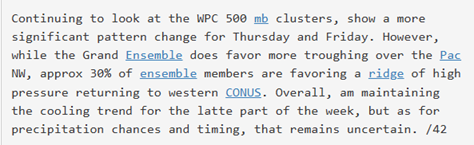
Good morning, neighbors! Unseasonably warm weather continues this week with high temps hovering a few or a lot of degrees above normal: normal is somewhere between SIX-SEVEN and 70 degrees for Hood River and 71 to 74 for The Dalles. Cooler temps are possible for a couple days at the end of the week, but models suggest we’ll hop right back on the warm-weather train for the following week. All that said, NWS is only predicting a cooling trend in the “latte” part of the week, so perhaps it will only be cool in the morning? Or only cool whenever you are drinking a latte?
Sunday started off with Glenwood as the superstar with a 36 degree start. Next chance for frost anywhere in the region starts next Friday, but there’s too much model spread to either breathe a sigh of relief or start to panic. If you are desperate to encounter sub-freezing temps, try cleaning out your chest freezer in preparation for this summer’s bounty of fresh fish and produce!
Sunday won’t be a great day to add to the chest freezer, but it will be a good day to be outside thanks to high clouds, cooler temps, and a breeze. West wind rises to 20-25mph west of Celilo Village by late morning and builds to 25-35mph from Mosier to Threemile this afternoon. High temps range from 73F (Hood River) to 77F (The Dalles), 84F (Pasco), and 108F (Garoua, Cameroon, where it was 116F yesterday).
After Sunday’s weather system moves through, we’re left with a mostly clear Monday thanks to high pressure. Morning temps along the Nch’i Wana will be in the mid 40s. Frost: naw. Afternoon temps rise to 80 degrees. Need a near-zero wind morning? Monday is your day. Conditions will be dead calm early with light easterlies from mid-morning on. Strongest wind will be E 15mph near Stevenson and E 10mph near Iwash (male genit*lia) Rock.
Thanks to some high clouds Tuesday morning, temps start warmer: low 50s. Southerly flow aloft maintains thin high clouds. Down below the clouds, we’ll see temps rise to 86F (Hood River) and 90-92F from The Dalles eastward. East wind starts the day at 25mph near Iwash (dick) Rock and Stevenson with light easterlies elsewhere. Afternoon wind falls to 10-15mph in the western Gorge and continues to be light easterly in other locations.
Uncertainty skyrockets on Wednesday as models struggle to resolve the path of an incoming trough. Wednesday is likely to be cooler, windier, and cloudier than Monday or Tuesday. As we move into Thursday and Friday and Saturday, temps definitely cool off, and west wind definitely picks up. Uncertainty continues past the weekend, but we’re likely to see warmer weather next week. Nothing too extreme, but probably warmer than “normal”, whatever that means these days. Safe travels. -TATAS
HEY! DON’T STOP READING! Is this community-focused forecast helpful to you? It sure is! It takes me a couple hours a day to write. Please join your friends and neighbors in contributing to keep it going. Venmo: @thegorgeismygym PayPal: twomirrors@gmail.com USPS: Temira / PO Box 841 / Hood River, Oregon 97031 You can test out the forecast subscription for a few days for free by signing up below. Easy! Do it!
JONES BEACH, SAUVIE ISLAND, & COAST FORECAST
ON WINTER VACATION UNLESS DESPERATELY NEEDED.
MT HOOD SNOW FORECAST

QR codes and links for end-of-season tips – thank you!!!
Cash/check: Temira – PO BOX 841 – Hood River, Oregon 97031


