


Thank you for using this forecast. I offer it freely so you can have more fun and plan your life. It does take significant time and energy to produce. If you find yourself using it often, or if you feel your life is more awesome because of my work, please make a donation. You can get this forecast via email by donation. The email subscription isn’t $99/year. Not $50/year. Donating $12.34 or more gets you on the list for 12 months. Thank you for your support and thank you for trusting my forecast.
Click here to donate using a credit card.
Click here to donate via PayPal.
Venmo: @theGorgeismyGym
Snail Mail: PO Box 841, Hood River, Oregon 97031
Get the email version free through the end of August – try it out! Click here.
| Your favorite beach | Dawn Patrol |
9am- 11:30a |
11:30a- 3pm |
3pm- dusk |
|
|---|---|---|---|---|---|
| Rooster Rock | lightning | strikes | buns | a’fright | |
| Steven’s Locks | 10-13 | 10-13 | 15-18 | G15-18 | |
| Swell-Hood River | 10-13 | 10-13 | 15-18 | thunder | |
| Doug’s, Lyle, Rowena | 10-13 | 10-13 | 7-10 | lightning | |
| Rufus, etc. | 10-13 | 10-13 | 7-10 | lightning | |
| Roosevelt & Arlington | 10-13 | 10-13 | 7-10 | lightning | |
Gorge Wind Forecast
Today’s A Low pressure moving inland on Saturday will bring some westerlies, but also another round of thunder and lightning. The weather stabilizes on Sunday, but lingering clouds in the west shift the wind a bit east. Models disagree on the strength of the westerlies on Monday.
For Saturday, you’ll want to get what you can before the thunder returns mid-afternoon. Morning westerlies will be 11-14 or so through the entire Gorge, but driving eastward probably isn’t the right choice today. Expect the wind to build to 15-18 or so from Stevenson to Hood River by early afternoon with 7-10 out east. We may see a brief period of gusty 22-25 from Stevenson to Mosier this afternoon before storms arrive and make the river an unsafe place to be. River flow is 148 kcfs and temp is 70 degrees.
A marine layer pushes in on Sunday and stabilizes the local weather. Models suggest the western Gorge wind will fade as the day goes on. We start with 15-18 from Stevenson to Hood River with 24-27 from Mosier to Roosevelt. Western Gorge wind fades to 11-14, and Mosier to Roosevelt fades to 22-25 in the afternoon.
Predictions for Monday vary among the models, but the GFS does tend to underplay things with this setup. It’s calling for single digits early with low double digits in the afternoon. The Euro is more robust, calling for peak speeds in the 19-23 range. Looking at the general picture for the rest of the week… support arrives in the form of offshore high pressure. That’s a setup known for steadier, stronger westerlies. Rest up for it!
COAST, JONES, SAUVIE’S: Coast (north/central/south, wind N unless otherwise specified). Saturday: NW5/LTNW/LTV, NW swell 3′ at 8 seconds. Sunday: LTW/LTW/N10-15, NW 2′ @8. Monday: LTW/NW5/N15-20, SW 2′ @ 16. Jones Saturday: 25-28. sunday: 7-10. Monday: 15-18. Sauvie’s Saturday: nope. Sunday: 7-10. Monday: 5-8.
Hood River Weather Forecast
A partial nothing cloud this morning gives way to brief clearing and another round of thunderheads. Temps will be in the low 60’s early and mid 70’s later. Muggy. Moderate westerlies. 16% chance of rainbows. Sunday starts with low clouds and ends clear. Temps will be in the upper 50’s early and mid 70’s later. Moderate westerlies. No rainbows. Monday looks partly cloudy. Temps will be in the mid 50’s early and near 80 in the afternoon. Light west wind. No rainbows.
Looking for a complete Columbia Gorge forecast? Looking for more humor in your weather? Obscenities? You’re looking for my TATAS: Temira’s Awesome Travel Advisory Service on Facebook.
Road and Mountain Biking
Industrial Fire Level is now Level III. Moto is no longer allowed on trails or unimproved roads, including in Post Canyon. Kreps land and SDS lands will close within the next couple of weeks due to fire danger – date is not yet set. Riorden Hill Road is closed between the end of the pavement and Family Man. Family Man is also closed, as is access to it, meaning you will need to choose other routes to Upper Post. Red Hill Road is theoretically closed to cars due to logging. Folks have ridden it on bikes on the weekend, but ride at your own risk. Chip sealing will happen on Highway 30 between Mosier and Rowena Crest August 12-14.
All local trails are open – I received confirmation of Huffman Peak too. Apparently Boulder Lakes is quite overgrown. Whoopdee is closed for logging, but Ronnoc trail and the climb out are open. Red Hill Road is supposedly closed for logging. Ride at your own risk. If you’re riding Underwood, please do not park at the trailhead as per request by SDS. Continue past the trailhead 0.5 miles or so to the new parking area. The cows are off Hospital Hill, which means your dog can come along.
Upcoming Events
Today’s the waterfront music festival in Stevenson. That’s your only opportunity to dance today, but you can check out these events: there’s a Horse Show in Stevenson today. Post Canyon has the 50k ultramarathon today, and the Bridge of the Gods Run is tomorrow. Movie fans can catch Mary Poppins tonight at Sorosis Park in The Dalles. Meadows planned for a stargazing party tonight, but it remains to be seen if the starts will be out. The sky should clear in time for the peak of the Perseids early Monday and Tuesday.
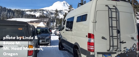
White Sprinter Van of the Week!
Click here for the White Sprinter Van map of the world!!!
Random Morning Thoughts: on vacation.
Click here for the full events calendar.
Have an awesome day today!
Temira
