

GORGE WIND FORECAST
If you’re still seeing yesterday’s and it’s after 9am, try opening this in an incognito window
SHORT-TERM gorge wind forecast
Hi friends! Sounds like you had a few good days of wind while I was on retreat. Yay! Happy for you! More wind is forecast for you in the next few days, and rest days will be mixed in there too. Uncertainty skyrockets after Monday, so don’t trust any forecasts beyond that for now. Happy to let you know when the uncertainty settles down! In the meantime…
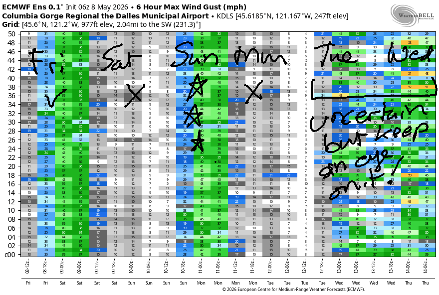
Let’s settle down into today’s wind forecast, shall we? Friday started with pressures of 30.09/29.99/29.93 for gradients of 0.10/0.06. That’s a good start and points to a day with potential for wind from the Corridor to the near east. A weak system moves through the area today and leaves us with stabilizing conditions this afternoon. For the morning, you’ll find gusty 20-23mph from Viento to the Hatch with 17-20mph at Stevenson, Hood River, and Mosier. To the east: 7-10mph near Rowena and 15-18mph from Avery to Arlington. We’ll see a mid-morning bump to gusty 24-27mph from Avery to Threemile as this system moves through.
Afternoon leaves us with partly cloudy sky to the west, sun to the east, and stronger westerlies. Stevenson to Hood River hangs in with 20-23mph, Mosier gets 22-25mph, and Lyle to Arlington rises to gusty 27-31mph. River flow sites aren’t up to date, but yesterday was 189-211kcfs for The Dalles and 216-228kcfs for Rufus. River temp is 56.5F, and high temp forecasts range from 71F for Hood River to 82F for Pasco.
RIVER FLOW FOR SITES BETWEEN AVERY (EAST OF THE DALLES) AND RUFUS: CLICK HERE FOR JOHN DAY DAM FLOW.
RIVER FLOW FOR SITES BETWEEN STEVENSON AND DOUG’S BEACH (WEST OF THE DALLES): CLICK HERE FOR THE DALLES DAM FLOW

LONGER-TERM gorge wind forecast
High pressure moves inland on Saturday and shuts things down (mostly). Morning wind will be 5-10mph from Stevenson to The Hatch (at best) and potentially calm for a period. After 2pm, the wind slowly rises to 11-14mph from Stevenson to Hood River with calm wind elsewhere. High temp: 81F with partly cloudy sky.
A trough approaches Sunday and combines with high pressure offshore for an excellent day on the river. TJ’s Dawn Patrol looks like gusty 25-28mph from Stevenson to Mosier with 12-15mph near Rowena and less wind out east. By late morning, we’ll have 28-32mph from Stevenson to Doug’s with 22-25mph from Rufus to Arlington. Given all the movement, a mid-morning crash is possible at the Hatchery. If this happens, don’t freak out. Afternoon wind looks like 29-33mph from Viento to Rufus with 22-26mph at cloudy Stevenson. Best bet: to the east, my friends! After 5pm, the wind starts to fade, but there should still be plenty from Mosier east to Arlington or maybe even Threemile. High temps range from 74F to 86F for solid thermal support.
Monday and Tuesday are likely to bring warmer weather and light east wind, although there’s enough uncertainty on Tuesday that we could actually see westerlies. Models indicate some sort of cooldown (maybe) for the middle of next week, but uncertainty is quite high. I’ll leave this here for now due to the lack of clarity. Hope to see you on the Nch’i Wana today and Sunday!

Was that helpful? I knew it was! Guess what? All of this crucial work – from your personal wind and snow reports to the invaluable TATAS updates – is made possible by my relentless efforts. Maintaining this labor of love isn’t easy. Each daily forecast takes hours. Website hosting, weather model access, and back-end admin work takes time and money. That’s where you come in.
YOUR CONTRIBUTION MAKES A DIFFERENCE
- SUPPORT ACCURATE, HYPER-LOCAL WEATHER FORECASTING
- ENABLE ACCESS FOR ALL, EVEN THOSE WITH LESS MEANS
- SUPPORT A COOL HUMAN WHO WORKS HARD SO YOU CAN PLAY
Take a moment to click one of the buttons below. Donate $19.99 or more (how much does this forecast enhance your life?) and get the email in your inbox. Whether it’s a renewing subscription (auto-renew) or a one-time donation, every contribution makes a real difference. Help me keep this labor of love alive, so we can all continue playing, commuting, and living in the Gorge with peace of mind and the best weather forecasts possible. Thank you!


Hood River, Oregon 97031


BARE BONES HOOD RIVER WEATHER FORECAST
High clouds this morning. Partly cloudy later. Temps start in the upper 50s and finish in the low 70s. Moderate to moderately strong westerlies. No rainbows. Saturday will be partly cloudy then partly high cloudy. Temps start in the mid 40s and rise to the low80s. Calm wind early. Moderate westerlies later. No rainbows. Sunday will be cloudy then partly cloudy. Temps start in the low 50s and rise to the mid 70s. Strong to nuking westerlies. No rainbows.
TEMIRA’S AWESOME TRAVEL ADVISORY SERVICE
HYPERLOCAL WEATHER FORECAST FOR THE COLUMBIA GORGE
THE DALLES, HOOD RIVER, WHITE SALMON, TROUT LAKE, STEVENSON, CASCADE LOCKS, PARKDALE, ODELL, HUSUM, BZ, MILL A, WILLARD, GOLDENDALE, RUFUS, ARLINGTON, boardman
Good morning, neighbors! It’s sooooooo good to be back with all of you in our beautiful community! Looks like it’s been warm (record warm mornings!) and breezy the last few days. The trend continues today. Nezt up: warm, not-so-windy weather Saturday and then a blasting wind day on Sunday. Model agreement falls apart by Tuesday, and on Wednesday, there’s a 20 degree spread in the possible high temps. Next chance of any rain at all: next weekend….
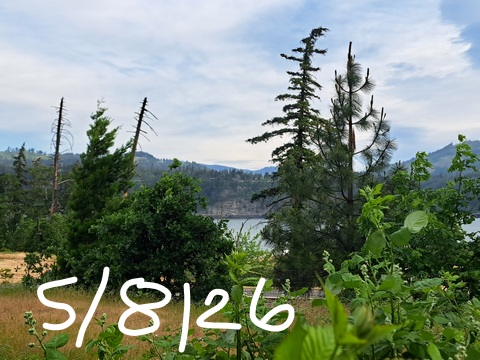
Glenwood this morning
Despite near-record warmth (57F with a record of 58F) in Hood River this morning, it’s only 40F in Glenwood. This is why MY tomatoes are getting planted and Glenwood’s aren’t. But don’t worry, Glenwood – I’ll have plenty to share!
Today’s Gorge weather forecast
Weather today looks damned fine for gardening. After a cloudy start, we’re left with Little Fluffy Clouds to the west and clear sky east of Mosier or so. Temps rise to 71F (Hood River), 75F (The Dalles) and 82F (The Desert). West wind will be 15-20mph west of Mosier early with 10-15mph to the east. Midday: 20mph west of The Dalles, 25mph east to Threemile Canyon, which is more than three miles long, less than three miles wide, and lower than three miles in elevation. I assumed all that, by the way, so don’t rely on it because I might be hallucinating like an AI. Afternoon wind: 20-25mph between Stevenson and Mosier with 25-30mph from Lyle to Arlington.
Saturday’s Gorge weather forecast
Overnight into Saturday, the week turns into the weekend. Amazing how that happens every week, isn’t it? Areas west of Hood River start the day with some low clouds. Areas to the east start clear. Despite the addition of a few high clouds everywhere in the afternoon, it’ll be quite warm: low 80s to the west and east and mid 80s for The Dalles, hottest place in Da Gorge. Hotter than even me, and I’m the hottest non-binary weather forecaster in the Gorge! Back to the weather outside my pants… it won’t be very windy Saturday – light or calm all day east of Hood River with westerlies at 10-15mph west of Mosier in the afternoon, and only in the afternoon, not in the morning.
I should say that I’m really jacked up on Prednisone this morning, so don’t mind the hypomania.
Sunday’s Gorge weather forecast
Weather “stuff” happens on Sunday. Result: cooler temps for the west side, hotter temps for the east side, and BLASTING west wind for all. Happy: ME, cuz I’m a boardhead. Happy: tumbleweeds! Unhappy: anyone who choose to be irritated by the wind – better to choose to simply accept it and even better to choose to be excited for peeps who are having fun with it! Morning temps will be in the low 50s under mostly cloudy sky. Afternoon: 74F to the west (with low clouds), 78F in The Dalles (sunny), and 86F in the desert (sunny). Wind will be 25-30mph to start from Stevenson to Mosier with 10-15mph to the east. By afternoon: 30+mph all through the Gorge.
Extended Gorge weather forecast
It’s likely Monday will be warm (80+) and sunny with light east wind, but after that, model agreement falters. Tuesday will probably be quite warm – 80+ for sure, but the spread is almost 10 degrees. Exponentially bigger uncertainty is present Wednesday, when the possible high temps range from the mid 60s to nearly 90 degrees. Spread is even more impressive aloft where 850mb temp forecast range is 5C to 20C on Wednesday!
It’s likely but not certain we’ll see cooler weather towards the end of next week with a little rain possible next weekend, but seriously don’t make plans around that yet. Model uncertainty is high. In a crazy twist, 850mb temps could potentially drop to the 0-5C range next weekend. Combine that with the possibility of moisture for a little mountain snow and a slight chance of frost for select areas of the Gorge. We’ll keep a close eye on it. That said, I’m planting my tomatoes in Hood River tomorrow. Fuck it. Happy gardening. Safe travels. -TATAS
HEY! DON’T STOP READING! Is this community-focused forecast helpful to you? It sure is! It takes me a couple hours a day to write. Please join your friends and neighbors in contributing to keep it going. Venmo: @thegorgeismygym PayPal: twomirrors@gmail.com USPS: Temira / PO Box 841 / Hood River, Oregon 97031 You can test out the forecast subscription for a few days for free by signing up below. Easy! Do it!
JONES BEACH, SAUVIE ISLAND, & COAST FORECAST
ON WINTER VACATION UNLESS DESPERATELY NEEDED.
MT HOOD SNOW FORECAST

QR codes and links for end-of-season tips – thank you!!!
Cash/check: Temira – PO BOX 841 – Hood River, Oregon 97031


