

GORGE WIND FORECAST
If you’re still seeing yesterday’s and it’s after 9am, try opening this in an incognito window
SHORT-TERM gorge wind forecast
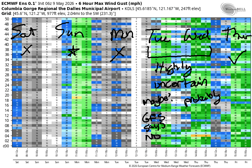
Hi friends! Nice to see some of you on the river yesterday. Unless you’re doing dock starting or E-foil or SUP or some other light-wind activity, we won’t meet on the water again until tomorrow (Sunday). Make plans to make the most of it – another rest day is likely on Monday. Next high-probability day is Wednesday, and models do like the idea of wind for the latter half of the upcoming week.
Looking at Saturday morning… it’s not quite glassy out there now (it’s light westerly), but it might turn dead calm at some point this morning. Pressures started at 30.16/30.13/30.13… not much to work with. By afternoon, temps equalize across the Cascades, and the wind turns light easterly, perhaps 5-10mph near Stevenson. River flow over the last 24 hours was 214-233kcfs, river temp is 56.7F, and high temp forecast is 81F for Hood River.
A weather system on Sunday gives us several helpful factors: weak high pressure offshore, reinforcing cool air and clouds on the west side, hot weather in the desert. We’ll have at least 10 degrees of cross-Cascade temp gradient to help us out. Given the moving parts, there’s likely to be an unreliable/gusty period of wind midday.
Get after the dawn patrol for 23-26mph from Viento to Mosier with 13-16mph near Rowena. East of there, DP will be light. It’s possible we’ll see a bump to 27-31mph from Viento to Mosier in the dawn patrol prior to the wind dropping at the Hatch; it’s likely the hatch will fall to gusty 19-23mph with the entrance of this weather system. From Mosier to Threemile, we’ll see the wind climb to gusty 28-32mph in the afternoon. After 5pm, it falls to 25-28mph. High temp: 74F in Hood River and 85F out in the desert with increasing clouds midday and clearing out east in the afternoon.
RIVER FLOW FOR SITES BETWEEN AVERY (EAST OF THE DALLES) AND RUFUS: CLICK HERE FOR JOHN DAY DAM FLOW.
RIVER FLOW FOR SITES BETWEEN STEVENSON AND DOUG’S BEACH (WEST OF THE DALLES): CLICK HERE FOR THE DALLES DAM FLOW

LONGER-TERM gorge wind forecast
Warm, dry, sunny weather sets up across the region on Monday. We’re left calm to start. Midday wind rises to E 10-15mph at Iwash (Rooster) Rock and Stevenson. High temp: 81F.
Uncertainty increases on Tuesday as models struggle to resolve whatever they’re struggling with! The GFS calls for easterlies at 15-20mph. The Euro ensembles give us a shot at both light easterlies and light westerlies. Better agreement exists in the models for Wednesday – we’re likely to see west wind, but the details are unclear. Westerlies are likely again for the latter half of next week along with much cooler temps compared to what we’re seeing today. Hope to see you on the Nch’i Wana for some of this wind!

Was that helpful? I knew it was! Guess what? All of this crucial work – from your personal wind and snow reports to the invaluable TATAS updates – is made possible by my relentless efforts. Maintaining this labor of love isn’t easy. Each daily forecast takes hours. Website hosting, weather model access, and back-end admin work takes time and money. That’s where you come in.
YOUR CONTRIBUTION MAKES A DIFFERENCE
- SUPPORT ACCURATE, HYPER-LOCAL WEATHER FORECASTING
- ENABLE ACCESS FOR ALL, EVEN THOSE WITH LESS MEANS
- SUPPORT A COOL HUMAN WHO WORKS HARD SO YOU CAN PLAY
Take a moment to click one of the buttons below. Donate $19.99 or more (how much does this forecast enhance your life?) and get the email in your inbox. Whether it’s a renewing subscription (auto-renew) or a one-time donation, every contribution makes a real difference. Help me keep this labor of love alive, so we can all continue playing, commuting, and living in the Gorge with peace of mind and the best weather forecasts possible. Thank you!


Hood River, Oregon 97031


BARE BONES HOOD RIVER WEATHER FORECAST
Clear sky this morning adds a few high clouds later. Temps start in the low 50s and rise to the lo w80s. Light and variable wind. No rainbows. Sunday will be cloudy then partly cloudy. Temps start in the l0w 50s and rise to the mid 70s. Strong to very strong westerlies. No rainbows. Monday will be partly cloudy then mostly clear. Temps start in the mid 40s and rise to the low 80s. Calm wind early. Light easterlies later. No rainbows.
TEMIRA’S AWESOME TRAVEL ADVISORY SERVICE
HYPERLOCAL WEATHER FORECAST FOR THE COLUMBIA GORGE
THE DALLES, HOOD RIVER, WHITE SALMON, TROUT LAKE, STEVENSON, CASCADE LOCKS, PARKDALE, ODELL, HUSUM, BZ, MILL A, WILLARD, GOLDENDALE, RUFUS, ARLINGTON, boardman
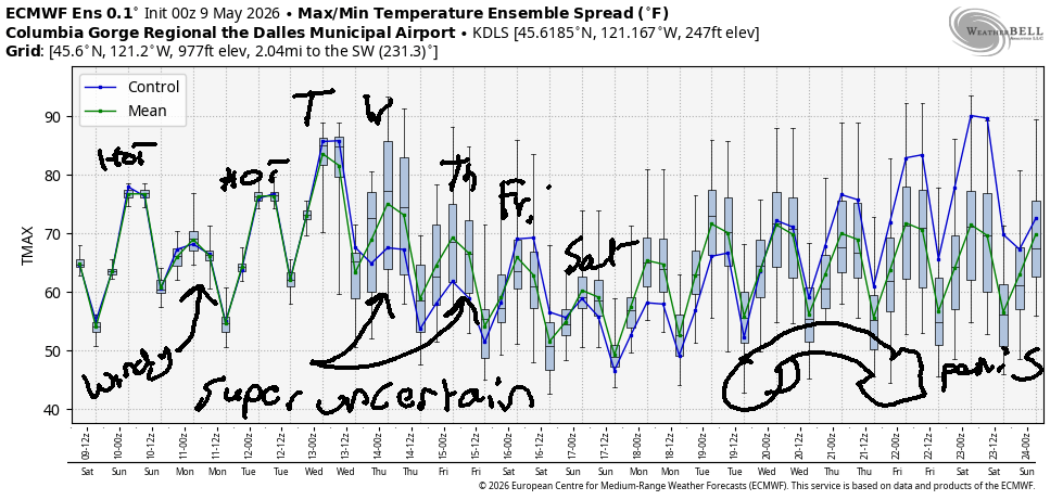
Good morning, neighbors! Sure looks like summer out there this morning – perfectly clear sky, light wind, floods of tourists headed this way on I-84… Today’s tourists will be of the hiking/beer drinking type. Tomorrow’s: wind johnnies. Looking at the upcoming week or so, we have warm, calm weather today, Monday and Tuesday; cooler/windy weather for Mom’s Day; warmth on Tuesday, and somewhat cooler weather into the end of the week. We might even see a tiny bit of rain in the latter half of the week or next weekend. Growers: we’ll keep a close eye on Friday and Saturday mornings as there’s some potential for temps to dip low enough for a light frost…
Glenwood this morning and today’s Gorge weather forecast
Speaking of frost…. guess where there’s frost this morning? GLENWOOD!!! Thermometers were reading 32F there this morning which is merely 47% of 67! After this chilly start (it’s as cold as 38F in Parkdale, FYI), temps warm up to the low 80s all across the lowlands. Wind today will be light westerly early, calm midday, and light easterly this afternoon. We should add just enough high clouds later today to make for a colorful sunset, and temps will be warm enough to make it worthy of hanging outside to watch. Make your sunset-watching more fun by drinking soda water and burping the word “ouch” loudly.
Sunday’s Gorge weather forecast
Ma Nature shakes things up on Sunday by sending a shortwave through. A shortwave is when short people wave. “Short” is defined as under 5’0”, so it’s mostly youth doing the waving. We’ll start the day warm: low 50s in the lowlands with low clouds to the west and mostly clear sky tot he east. Clouds increase during the day, but never completely obscure the blue sky east of The Dalles. Temps rise to the low 70s (west), upper 70s in The Dalles, and mid 80s in the desert. If you’ve been paying attention, you know that a cross-Cascade temp gradient of this size will result in strong west wind. Indeed: 25mph to start west of Mosier with 10mph to the east. Afternoon: 20-30mph west of Mosier and 25-35mph east of Mosier to Arlington. Wind Johnny Boardheads: ecstatic.
Monday’s Gorge weather forecast
After the passing of Sunday’s system, we’re left with the passing of Monday morning’s poop. Get it out of the way early! Sky coverage Monday morning will be partly cloudy west of Mosier and clear to the east. Given calm wind, Glenwood will potentially frost again, but other locations should be above 36F with mid 40s down low. Thanks to high pressure inland, the rest of the day will be sunny with light east wind and temps from 81-84F.
Extended Gorge weather forecast
Warm weather continues on Tuesday (probably) with light east wind (probably), although there is some model disagreement. Agreement falls apart on Wednesday as the ECMWF ensemble calls for high temps in The Dalles anywhere from 63F to 81F. Signs are more clear of a cooldown for the rest of the week with an increasing chance of light drizzle as we move later into the week. Should you plant your tomatoes? I am. But if you’re at elevation, you’ll want to keep a close eye on next Friday and Saturday as models do hint at the possibility of unseasonably cool air aloft. We’ll watch it and see. Safe travels. -TATAS
HEY! DON’T STOP READING! Is this community-focused forecast helpful to you? It sure is! It takes me a couple hours a day to write. Please join your friends and neighbors in contributing to keep it going. Venmo: @thegorgeismygym PayPal: twomirrors@gmail.com USPS: Temira / PO Box 841 / Hood River, Oregon 97031 You can test out the forecast subscription for a few days for free by signing up below. Easy! Do it!
MT HOOD SNOW FORECAST

QR codes and links for end-of-season tips – thank you!!!
Cash/check: Temira – PO BOX 841 – Hood River, Oregon 97031


JONES BEACH, SAUVIE ISLAND, & COAST FORECAST
ON WINTER VACATION UNLESS DESPERATELY NEEDED.
