| Snow level | 4a-8a | 8a-12p | 12p-4p | 4p-8p | 8p-4a |
|---|---|---|---|---|---|
| Saturday 4000′->5500′->4000′ |
 |
|
|
 |
|
| Sunday 4000′->8500′ |
|
|
|
|
|
| Monday 8500′->10,000′ |
|
|
|
|
|
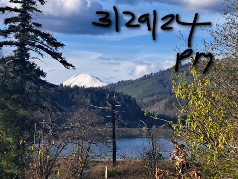
Mt. Hood Snow Forecast
If you like sunshine with your snow, you’ll get it this weekend. Also, temps won’t be super warm on the slopes, so the snow will hold up for at least part of the day. The weather turns warmer Monday and Tuesday – the freezing level rises to 10,000′. After that, we’re back to cooler weather on the slopes with maybe half a foot of snow forecast for Wednesday.
In the meantime… Saturday will be sunny all day with a few mid-level clouds in the afternoon. The free air freezing level (FAF) will be 4000′ all day and 5500′ overnight with temps maxing out in the mid 30s at 5000′. Wind: E 15 in the morning, W 10-15 in the afternoon, and N 10 overnight. Sunday will be sunny. The FAF will be 4000′ in the morning, 5500′ in the afternoon, and 8500′ after midnight. Temps max out in the mid to upper 30s after a sub-freezing start. Wind: N 10 in the morning and afternoon and N 20 after midnight. Expect hardpack conditions both days softening up in sunny areas in the afternoon (today, Friday, was packed powder).
Monday will be warmer. The FAF rises from 8500′ in the morning to 10,000′ in the afternoon. Wind: N 20 all day and NW 5-10 overnight. High temps will be in the low 40s. Tuesday looks sunny and warm with the FAF at 10,000′. Temps max out near 50. A warm start to Wednesday gives way to a snowy afternoon as temps fall from +10C to -3C at 5000′ during the day. About half a foot of snow is forecast in the 24 hour period. After that? Cooler with intermittent light snow for a while. Winter ain’t over!
A poem:
Was that forecast helpful?
Did it save you time or gas money?
Did it make your life more fun?
Then please make a contribution.
Writing this takes me an hour or two a day.
Without your support, I can’t keep it up.
Keep the forecast going.
Subscribe or donate.
And share my forecast with your friends!
 |
 |
 |
|
Not ready to subscribe? No problem – please share this forecast with all your friends too!
Or try a month for free!

Gorge Wind Forecast
Hi friends! Lots of times the models back off, but this time they’re changing in our favor. Does west wind and 60+ degree weather sound good? You’re in the right place! Saturday starts with E 15-20 at Iwash (Rooster) and E 10-15 at Stevenson. The wind quickly drops to 10mph at both places and goes calm all through the Gorge early in the afternoon. A weak system containing cooler air pushes into the west half of the PNW late in the day and, if the timing is just right, drives westerlies at 17-20 from Stevenson to Mosier or Doug’s. River flow Friday was 133-173kcfs, river temp is 47.6F, and high temp forecast is 63F.
A nice marine layer on the west side burns off Sunday afternoon as warmer, dry air arrives from the north. Still… the onshore temp gradient remains all day. Expect 21-24 from Viento to Mosier or The Dalles early Sunday (Dawn Patrol!) with 14-17 east of The Dalles to Arlington. The wind drops to 7-10 out east by late morning. Between Stevenson and Mosier, the wind holds at 21-24 or so. In the afternoon, as the west side warms, the wind drops to 14-17. High temp: 63F. The warm ridge moves to the east side of the Cascades by Monday morning, and offshore high pressure holds. Expect 22-25 Dawn Patrol from Stevenson to Mosier with 13-16 out east. Mid-morning wind climbs to 25-28 from Stevenson to Mosier with 18-22 from Lyle to Doug’s and 13-16 east of The Dalles to Arlington. The wind may drop a little in the afternoon, but generally speaking, it’ll be windy all day. High temp: 67F.
Extended forecast: Tuesday: 13-16. Wednesday: 24-27 near the Hatch early. 28-32 from Avery to Threemile in the afternoon. Expect the wind to be less punchy and less reliable than Monday’s wind. It’ll also be quite a bit cooler – perhaps low to mid 50s. Ready? Set. Go!
 |
|
Jones, Sauvie’s, Coast Forecast – On vacation ‘til summer unless otherwise noted
Very basic Hood River weather forecast. Don’t plan your life around this. You really should read TATAS
Warm and dry for the next four days. On Saturday, the sky will be clear then mostly clear. Temps start in the mid 30’s and rise to the low 60’s. Light easterlies in he morning. Calm wind midday. Moderate westerlies in the evening. No rainbows. Sunday will be mostly clear then clear. Temps start in the upper 30’s and rise to the low 60s. Moderately strong westerlies. No rainbows. Monday will be mostly clear. Temps start near 40 and rise to the upper 60s. Strong westerlies. No rainbows. Read Temira’s Awesome Travel Advisory Service on Facebook for a detailed forecast that may help you plan your day.
Local-ish Events
Please let me know of outdoor-related local-ish events. If you don’t tell me, I don’t know!
Indian Bowl and Roll (the baby sis to Amayah’s) opens April 5th in Hood Rivert. The White Salmon – Bingen community-wide yard sale is April 19th and 20th. On April 16th at 6pm, Master Gardener Denis Carlson gives a talk at the Hood River Library on controlling rodents in your garden.
Regular weekly events:. NK Studio’s by-donation Tuesday morning yoga class is back. Ferment’s Tuesday night 4-mile walk/run is at 6pm. There’s meditation with monks at 5:15pm (an hour) and 6:30pm (30 minutes plus a talk) at Yoga Samadhi in White Salmon. The Tri Club is done for the season. At 7:15am on Wednesdays, there’s a run from the White Salmon Bakery. At 7am on Friday morning, there’s a run from Pine Street Bakery. On Fridays at 2:30pm, there’s a free meditation and stretching class at Yoga Samadhi. On Saturday at 9am, there’s a by-donation outdoor group fitness on the 2rd floor deck about Ferment Brewing.
Cycling
It’s pretty wet out there after a couple days of rain. Best chance for Saturday is Syncline. Maybe wait until Sunday before attempting other trails – they’ll be wet from the Wednesday/Thursday rain. Sisterwives and Kleeway in Post Canyon are currently closed for rebuilding. Regarding the trails in general: don’t ride in the mud. You’ll damage the trails. Don’t ride if it was below freezing the previous night and is above freezing (or sunny) when you go to ride; freeze-thaw trails are susceptible to permanent damage. Ride gravel. Ride your trainer. Build trails. There are trail builders seeking extra hands on seven additional miles of trail on Whoopdee. Contact HRATS for more information. If you’re parking at Post Canyon, you will need a parking pass. Those can be purchased at many local shops or online.
Sprinter Van of the Week!
 Click here for the Sprinter Van map of the world!!!
Have an awesome day!