

GORGE WIND FORECAST
If you’re still seeing yesterday’s and it’s after 9am, try opening this in an incognito window
SHORT-TERM gorge wind forecast
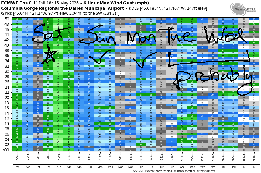
Hi friends! A long stretch of west wind remains in the cards in your favorite Gorge wind forecast. Today’s likely to be the strongest (although tomorrow could over-perform) – next week brings warming temps with lesser westerlies. There still should be plenty to get many of you on the Nch’i Wana for some fun.
Saturday morning kicked off with pressures of 30.21/30.15/30.08 and 30.47 offshore. Early gradients were 0.06/0.07. We’ll have a system moving inland this afternoon, and that will keep showers going on and off west of The Dalles into the evening. Morning wind will be gusty 14-17mph from Viento to Doug’s (cloudy, drizzly, and light in Stevenson) with 23-26mph from Avery to Boardman.
Afternoon wind drops below 15mph west of Lyle or west of The Dalles (depends on the rain brought by the incoming system), and rises to 30-33mph as far east as Arlington. East of Arlington, instability is likely to drive thunderstorms which will negatively impact the wind this afternoon. It’s possible thunderstorms could build in other locations as well; any storms will be surface-based and thus disruptive to the wind. River flow over the last 24 hours was 236-280kcfs (241-267 at Rufus), river temp is 57.7F, and high temp forecast is 57F in Hood River and 61-65F east of The Dalles.
RIVER FLOW FOR SITES BETWEEN AVERY (EAST OF THE DALLES) AND RUFUS: CLICK HERE FOR JOHN DAY DAM FLOW.
RIVER FLOW FOR SITES BETWEEN STEVENSON AND DOUG’S BEACH (WEST OF THE DALLES): CLICK HERE FOR THE DALLES DAM FLOW

LONGER-TERM gorge wind forecast
Another round of westerlies is forecast on Sunday. Models suggest we’ll have Dawn Patrol at 17-20mph from Viento to Rufus, but cold temps could result in lesser Dawn Patrol wind than models predict. With strong offshore high pressure lingering and clouds forecast to stick around (at least in part) on the west side, we may see reality beat models; with that in mind, late morning wind will likely rise to 22-25mph from Viento to Avery. Afternoon: 24-27mph from Mosier to Rufus. High temp: 65-70F, coldest to the west and warmest to the east. Some instability is forecast east of The Dalles – that will likely impact wind quality in the desert.
Westerlies continue on Monday. We start with 15-18mph from Viento to Mosier with 10-13mph in Stevenson and east of Mosier to Arlington. Afternoon wind rises to 23-26mph from Stevenson to Arlington. High temp: 70-75F. Similar conditions are forecast on Tuesday with slightly lesser wind on Wednesday. I’ll leave it there for now. See you on the Nch’i Wana soon!

Was that helpful? I knew it was! Guess what? All of this crucial work – from your personal wind and snow reports to the invaluable TATAS updates – is made possible by my relentless efforts. Maintaining this labor of love isn’t easy. Each daily forecast takes hours. Website hosting, weather model access, and back-end admin work takes time and money. That’s where you come in.
YOUR CONTRIBUTION MAKES A DIFFERENCE
- SUPPORT ACCURATE, HYPER-LOCAL WEATHER FORECASTING
- ENABLE ACCESS FOR ALL, EVEN THOSE WITH LESS MEANS
- SUPPORT A COOL HUMAN WHO WORKS HARD SO YOU CAN PLAY
Take a moment to click one of the buttons below. Donate $19.99 or more (how much does this forecast enhance your life?) and get the email in your inbox. Whether it’s a renewing subscription (auto-renew) or a one-time donation, every contribution makes a real difference. Help me keep this labor of love alive, so we can all continue playing, commuting, and living in the Gorge with peace of mind and the best weather forecasts possible. Thank you!


Hood River, Oregon 97031


JONES BEACH, SAUVIE ISLAND, & COAST FORECAST
Wind northerly unless otherwise indicated. For coast, it’s North/Central/South with the “central” at approximately Florence. Swell forecast from NWS for central coast. Jones: westerly unless otherwise stated. Sauvie Island: northerly unless otherwise stated. Coast Saturday: NW20-25/NNW20/N25-30, W swell 9′ at 13 seconds. Sunday: NNW10-15/N20/N30-40, NW 7′ @ 11. Monday: 10/15-20/25-30+, NW 6′ @ 16. Jones Saturday: 12-15. Sunday: 11-14. Monday: 18-21. Sauvie Island Saturday: WNW15-28. Sunday: 10-13. Monday: 11-14.
BARE BONES HOOD RIVER WEATHER FORECAST
Drizzle on and off into the evening with a slight chance of thunder. Dry overnight. Temps start in the mid 40s and rise to the upper 50s. Light to moderate westerlies. 99% chance of rainbows. Sunday will be cloudy then partly cloudy. Temps start in the upper 30s and rise to the mid 60s. Moderate westerlies. No rainbows. Monday will be cloudy then clear. Temps start in the low 40s and rise to 70. Moderate westerlies early. Moderately strong later. Mo rainbows.
TEMIRA’S AWESOME TRAVEL ADVISORY SERVICE
HYPERLOCAL WEATHER FORECAST FOR THE COLUMBIA GORGE
THE DALLES, HOOD RIVER, WHITE SALMON, TROUT LAKE, STEVENSON, CASCADE LOCKS, PARKDALE, ODELL, HUSUM, BZ, MILL A, WILLARD, GOLDENDALE, RUFUS, ARLINGTON, boardman
Good morning, neighbors! It’s chilly out there this morning, just like it was chilly yesterday afternoon. It was so chilly that I froze my butt off, and maybe you did too! It’s also chilly enough that Bennett Pass is snow-covered this morning, and there’s 4” of new snow at 5000′! Snow continues to accumulate at pass level through tonight – up to a foot is likely above 5000′. This leaves us with a chance of sub-freezing temps or frost here in the Gorge on Sunday morning for a select few folks. Beyond Sunday, we enter a warming spell with temps expected to climb towards 80 in The Dalles by the middle of the week.
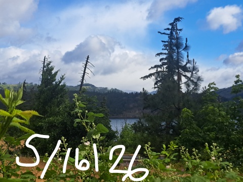
Glenwood this morning
Looking at this morning, we have a chilly start: cloudy Glenwood is 39 degrees and celebrating the achievements of upper Parkdale (36F) and Dufur (36F) and Trout Lake (36F).
Today’s Gorge weather forecast
Temps only rise to the mid 50s (west), 60ish (The Dalles) and 65F (Pasco) this afternoon as 850mb temps hover around -2C. Thanks to offshore high pressure and desert sunshine, west wind climbs today: 15mph west of Lye and, eventually, 30-35mph from Lyle to the Arlington Triangle. We’ll have intermittent rain into early evening as far east as The Dalles – watch out for sneaky rainbow – and thunderstorms are possible this afternoon anywhere the sun breaks through the clouds and warms the ground-level air. Thunderstorm potential ends with the setting of the sun. Snow level today: 3500′ falling briefly to 2500′ overnight before rising to 3500′ Sunday morning.
Sunday’s Gorge weather forecast
Sunday morning starts cloudy to the west and clear to the east with west wind at 15-20mph, dewpoints in the 28-38F range, 850mb temps at -2C. If the sky clears of clouds, or turns partly cloudy overnight in our growing zones, some wind-protected locations will be at risk of frost: Dufur, Trout Lake, Glenwood, Steele Road area of The Dalles, Snowden (above 2000′), High Prairie (above 2000′), and potentially Parkdale. If cloud cover is far less than anticipated, other areas could be added: Odell, Husum. Underwood. Goldendale and Centerville are likely to be too windy for frost, but if the wind isn’t present, there’s a risk there too. Given the fact that dewpoints are pretty high, a hard freeze is very unlikely – fog/clouds will form easily and keep temps from dropping too far.
Rest of Sunday: decreasing clouds with highs ranging from 65F in Hood River to 68F in The Dalles and 76F in Pasco. West wind will be 15-20mph to start from Viento to Rufus with 10-15mph east of Rufus. Afternoon: 15-20mph west of Mosier and east of Rufus with 25-30mph between Mosier and Rufus.
Monday’s Gorge weather forecast
Dry weather is forecast on Monday. The day starts with low and mid-level clouds to the west and high clouds to the east. The only place at risk of sub-freezing temps is Glenwood, and that’s only if the sky is clear there, which it probably wont’ be. The west side clears in the afternoon and tops out around 70F. The east side hangs on to a mix of mid and high-level clouds and finishes at 75 degrees. West wind rises from 15-20mph in the morning to 25mph in the afternoon with the wind filling in all the way from Stevenson to the Arlington triangle.
Extended Gorge weather forecast
Tuesday will be mostly sunny, frost-free, with highs ranging from 72F to 78F. West wind will be around 25mph. Similar, slightly warmer weather is forecast on Wednesday. Generally speaking, the weather stays dry and temps hang out in the 70s until next Saturday, after which uncertainty skyrockets and nobody can tell what the weather will do. Now if you’ll excuse me, I have to go see if there’s snow on Mt. Defiance. If there is, I guess I’ll pull all my tomatoes out of the ground because I shouldn’t have planted them yet. Safe travels. -TATAS
HEY! DON’T STOP READING! Is this community-focused forecast helpful to you? It sure is! It takes me a couple hours a day to write. Please join your friends and neighbors in contributing to keep it going. Venmo: @thegorgeismygym PayPal: twomirrors@gmail.com USPS: Temira / PO Box 841 / Hood River, Oregon 97031 You can test out the forecast subscription for a few days for free by signing up below. Easy! Do it!
MT HOOD SNOW FORECAST

QR codes and links for end-of-season tips – thank you!!!
Cash/check: Temira – PO BOX 841 – Hood River, Oregon 97031


