

GORGE WIND FORECAST
If you’re still seeing yesterday’s and it’s after 9am, try opening this in an incognito window
SHORT-TERM gorge wind forecast
Hi friends! Windy weather is on tap for much of the next week or so – today looks like a solid one all the way to out Rufus. Sunday’s Gorge wind forecast is a bit lighter, but wild weather and potentially nuking wind is in the cards on Memorial Day. Forecast certainty is lower from Tuesday onward, but generally speaking, westerlies of 17-20mph+ are in the cards for the long haul. Yay!
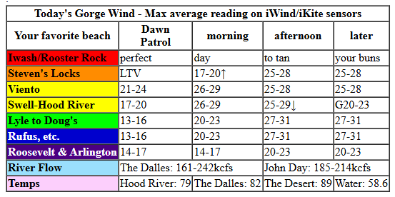
Saturday started with pressures of 29.94/29.82/29.80 and 30.24 offshore. Low clouds were present west of Hood River – “clouds in the hole” – and the metro area appeared mostly cloudy on webcams. Models do suggest the clouds will burn off relatively quickly today which will likely impact the Hatch wind. Dawn Patrol was under-performing gradients: 14-17mph or so from Viento to the Hatch with 10-13mph at Stevenson and also most locations east of Hood River to Arlington. Morning wind builds to 26-29mph from Viento to Mosier with 20-23mph near Rowena, Avery, and eventually from Maryhill to Rufus.
As the desert heat intensifies this afternoon and clouds dissipate in the metro area, two things happen: 1) the Hatch is likely to drop to gusty low 20s while Stevenson-Hood River holds at 25-28mph. From Mosier to Rufus, westerlies build to 27-31mph this afternoon. Arlington: 20-23mph. East of Arlington, the wind will be significantly lighter. River flow over the last 24 hours was 161-242kcfs (185-214kcfs at Rufus), River temp is 58.6F, and high temp forecast is 79F for Hood River and 89F way out east in the desert.
RIVER FLOW FOR SITES BETWEEN AVERY (EAST OF THE DALLES) AND RUFUS: CLICK HERE FOR JOHN DAY DAM FLOW.
RIVER FLOW FOR SITES BETWEEN STEVENSON AND DOUG’S BEACH (WEST OF THE DALLES): CLICK HERE FOR THE DALLES DAM FLOW

LONGER-TERM gorge wind forecast
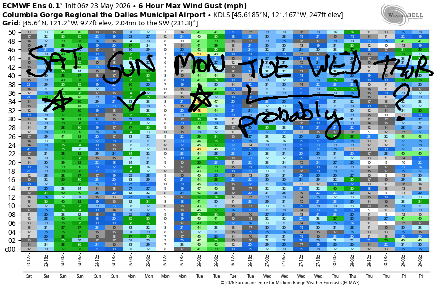
Sunday looks like a sunny day, all day, all the way from the metro area to the desert. Guess what else: there’s a CGW2 swap meet at Lot 1 in the morning! Offshore: decreasing pressure. Desert: heat low. This gives us 17-20mph in the morning from Viento to the Hatch. As a front approaches offshore in the afternoon, Stevenson-Hood River falls to 14-17mph, and Mosier-Arlington builds to 17-20mph. High temp: 79F in Hood River and 87F in the desert.
Monday looks exciting! An approaching cold front drives massive pressure gradients in the afternoon. This is not The Cooldown You Were Looking For – there’s instability and rain involved – but it does have the potential for a period of nuking westerlies. Don’t be fooled by the morning wind: 14-17mph from Stevenson to Arlington. As the cold front approaches in the afternoon and rain arrives for the west side, a big cross-Cascade temp and pressure gradient develop. 30+ mph is likely from Stevenson to Rufus by midday with 30+ mph (maybe a lot more) from Viento to Threemile for the mid-afternoon and early evening hours. These frontally-driven winds tend to be relatively short-lived (a few hours at best), so a pre-emptive drive should be considered. High temp forecast is 70F in Hood River and 85F in the desert.
Cooler, showery conditions persist on Tuesday and perhaps into Wednesday. Quite a bit of uncertainty is present in the wind forecast, but for now… call it 20-23mph on Tuesday and similar conditions on Wednesday. Beyond that, uncertainty increases. So, that’s the end of the forecast for today. See you on the Nch’i Wana soon!

Was that helpful? I knew it was! Guess what? All of this crucial work – from your personal wind and snow reports to the invaluable TATAS updates – is made possible by my relentless efforts. Maintaining this labor of love isn’t easy. Each daily forecast takes hours. Website hosting, weather model access, and back-end admin work takes time and money. That’s where you come in.
YOUR CONTRIBUTION MAKES A DIFFERENCE
- SUPPORT ACCURATE, HYPER-LOCAL WEATHER FORECASTING
- ENABLE ACCESS FOR ALL, EVEN THOSE WITH LESS MEANS
- SUPPORT A COOL HUMAN WHO WORKS HARD SO YOU CAN PLAY
Take a moment to click one of the buttons below. Donate $19.99 or more (how much does this forecast enhance your life?) and get the email in your inbox. Whether it’s a renewing subscription (auto-renew) or a one-time donation, every contribution makes a real difference. Help me keep this labor of love alive, so we can all continue playing, commuting, and living in the Gorge with peace of mind and the best weather forecasts possible. Thank you!


Hood River, Oregon 97031


JONES BEACH, SAUVIE ISLAND, & COAST FORECAST
Wind northerly unless otherwise indicated. For coast, it’s North/Central/South with the “central” at approximately Florence. Swell forecast from NWS for central coast. Jones: westerly unless otherwise stated. Sauvie Island: northerly unless otherwise stated.
Coast Saturday: 15-20/20-25/30-35, NW swell 6′ at 9 seconds. Sunday: LTW/LTNW/S10-15, NW 6′ @ 11. Monday: SW5-20/SW15/LTV, W 11′ @ 12. Jones Saturday: 18-21. Sunday: 14-17. Monday: LTW. Sauvie Island Saturday: 12-15. Sunday: 7-10. Monday: SW 15.
BARE BONES HOOD RIVER WEATHER FORECAST
Clear most of the day with high clouds later. Temps start in the mid 50s and rise to the upper 70s. Strong westerlies. No rainbows. Sunday will be partly high overcast. Temps start in the low 50s and rise to the upper 70s. Moderate westerlies. No rainbows. Monday will be partly cloudy then mostly cloudy. Temps start in the low 50s and rise to 70. Light westerlies early. Nuking later. Slight chance of thunder. Drizzle in the evening. 14% chance of rainbows.
TEMIRA’S AWESOME TRAVEL ADVISORY SERVICE
HYPERLOCAL WEATHER FORECAST FOR THE COLUMBIA GORGE
THE DALLES, HOOD RIVER, WHITE SALMON, TROUT LAKE, STEVENSON, CASCADE LOCKS, PARKDALE, ODELL, HUSUM, BZ, MILL A, WILLARD, GOLDENDALE, RUFUS, ARLINGTON, boardman
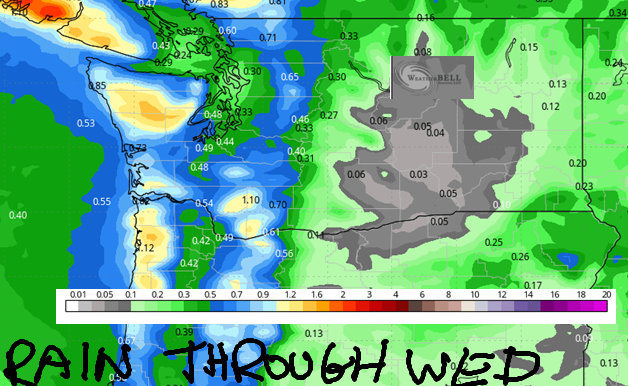
Good morning, neighbors! Another summery spring day is on tap… I keep forgetting it’s only May because it’s been warm and sunny and my tomatoes are so happy. But don’t you worry – a reminder of spring arrives Monday through Wednesday with cooler temps and some rain. We’re keeping our eyes on the wind on Monday as well – there’s some chance of strong-enough westerlies to, at the very lease, send your rubbish bin on an eastward walkabout. Also in the cards early next week: a bit of snow above 3500′ and a tiny chance of frost for Glenwood and Dufur on Tuesday morning should the sky clear Monday night.
Glenwood & Tehran this morning & today’s Gorge weather forecast
Speaking of Glenwood, it’s 41 degrees there this morning. In Tehran, Iran, where every human is a person deserving of love just like you, temps max out at 81F under sunny sky with relatively humidity of just 16%. Closer to home, where the bombs are not falling and people feel relatively safe, we’ll start with clouds to the west and clear sky to the east. West wind at 10-15mph this morning picks up to 25-30mph this afternoon, and all the low clouds burn away. Enough high clouds join the picture in the evening to give us a colorful sunset. Highs today max out near 76 in Stevenson, 79 n Hood River, 82 in The Dalles, and 89 in Pasco. All the Boardhead Wind Johnnies jump for joy and scatter to all the reaches of the Gorge.
Sunday’s Gorge weather forecast
Overnight into Sunday, we’re left with mostly clear sky and a few high clouds. A few clouds linger during the day, but we’ll mostly be sunny. After a 50ish degree start in the lowlands, temps rise to 76F in Stevenson with a temp gradient that ends at 87F in Pasco. West wind will be 15-20mph between Viento and Hood River early with 5-10mph to the east. Afternoon: 15-20mph everywhere between Stevenson and the Arlington Isosceles Triangle, which is right new to the Arlington Equilateral Triangle, which often gets into arguments with the Arlington Obtuse Triangle while caring for the Arlington Acute Triangle.
Monday’s (exciting) Gorge weather forecast
Cool shit happens on Monday! A chilly low drops down from Alaska and moves towards BC in search of universal healthcare (MEDICARE FOR ALL!). This triggers a massive cross-Cascade temp gradient, afternoon rain for the west side, a chance of thunder, and very strong west wind. Temps start in the 45-52F range and rise to 65F in Cascade Locks, 70F in Hood River, 76F in The Dalles, and 84F in Pasco. West wind starts at just 15mph, but it’ll rise to 30-40mph in the afternoon. Whoa! This is not the day to attempt a burn pile. It is, however, a great day to thank our service members and barbecue up some ribs for all your friends!
Extended Gorge weather forecast
Cooler temps and a little drizzle or showers continue into Tuesday and Wednesday. Up in the mountains, the snow level will be below 5000′ for much of this period. Not much snow is expected, but for folks working or playing at elevation, preparation will be key. Uncertainty rises on Wednesday with hints of a brief warming trend followed by cooling at the end of next week. After that: potentially warmer, but a huge range of possible outcomes in the forecast. So… let’s leave it there for now. Safe travels. -TATAS
HEY! DON’T STOP READING! Is this community-focused forecast helpful to you? It sure is! It takes me a couple hours a day to write. Please join your friends and neighbors in contributing to keep it going. Venmo: @thegorgeismygym PayPal: twomirrors@gmail.com USPS: Temira / PO Box 841 / Hood River, Oregon 97031 You can test out the forecast subscription for a few days for free by signing up below. Easy! Do it!
MT HOOD SNOW FORECAST

QR codes and links for end-of-season tips – thank you!!!
Cash/check: Temira – PO BOX 841 – Hood River, Oregon 97031


