

MT HOOD SNOW FORECAST

QR codes and links for end-of-season tips – thank you!!!
Cash/check: Temira – PO BOX 841 – Hood River, Oregon 97031


Hey skiers and snowboarders! Thank you so much for using this forecast all winter. I’m betting all of us wished for more snow. Hopefully this forecast helped you make the most of the snow we received. If it was helpful, please consider making an end-of-season tip to support me and all the work I put in to making your life more fun!
If you don’t use electronic payments, you can send cash or check to: Temira / PO Box 841 / Hood River, Oregon 97031
THANK YOU FOR YOUR SUPPORT!!! HAVE A GREAT SUMMER!!!
Sign up to try out the year-round forecast for wind, snow, and everything else!
Was that helpful? I knew it was! Guess what? All of this crucial work – from your personal wind and snow reports to the invaluable TATAS updates – is made possible by my relentless efforts. Maintaining this labor of love isn’t easy. Each daily forecast takes hours. Website hosting, weather model access, and back-end admin work takes time and money. That’s where you come in.
YOUR CONTRIBUTION MAKES A DIFFERENCE
- SUPPORT ACCURATE, HYPER-LOCAL WEATHER FORECASTING
- ENABLE ACCESS FOR ALL, EVEN THOSE WITH LESS MEANS
- SUPPORT A COOL HUMAN WHO WORKS HARD SO YOU CAN PLAY
Take a moment to click one of the buttons below. Donate $19.99 or more (how much does this forecast enhance your life?) and get the email in your inbox. Whether it’s a renewing subscription (auto-renew) or a one-time donation, every contribution makes a real difference. Help me keep this labor of love alive, so we can all continue playing, commuting, and living in the Gorge with peace of mind and the best weather forecasts possible. Thank you!


Hood River, Oregon 97031


GORGE WIND FORECAST
If you’re still seeing yesterday’s and it’s after 9am, try opening this in an incognito window
SHORT-TERM gorge wind forecast
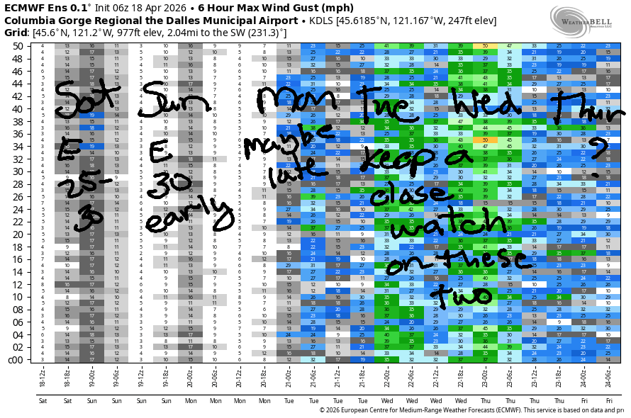
Hi friends! Moderate easterlies are in the Gorge wind forecast for the next couple of days. Starting Monday, there’s more uncertainty. Uncertainty is even higher Tuesday as a low pressure system moves inland. There’s some potential for a big west wind day on Wednesday in the wake of this low’s passage. More on that in a bit…
Saturday started with pressures of 30.07/30.14/30.16 for 0.07/0.02 easterly gradients. Morning wind will be 25-30mph near Iwash/Rooster and 20mph near Stevenson. After 11am, the wind starts fading. By later afternoon, Iwash readings will be around 10mph, and Stevenson will be down to 10-15mph. River flow over the last 24 hours was 210-247kcfs, river temp is 50.9F, and high temp forecast is 69F with increasingly clear sky.
RIVER FLOW FOR SITES BETWEEN AVERY (EAST OF THE DALLES) AND RUFUS: CLICK HERE FOR JOHN DAY DAM FLOW.
RIVER FLOW FOR SITES BETWEEN STEVENSON AND DOUG’S BEACH (WEST OF THE DALLES): CLICK HERE FOR THE DALLES DAM FLOW

LONGER-TERM gorge wind forecast
Sunday’s easterlies look a bit stronger. Early wind will be 30-35mph at Stevenson and 30mph at Iwash. If you want the strongest wind, move fast. Models suggest both spots will drop to 20-25mph by 11am and continue fading. Stevenson ends the day at 15mph, and Iwash ends light and variable. Other areas of the Gorge see easterlies rise to 5-10mph mid-morning and hold into the afternoon. High temp: 73F and partly to mostly cloudy.
Monday starts calm or light westerly. In response to desert heating, afternoon westerlies rise to 13-16mph or so. An offshore low nudges cooler air into the west side late in the day. If the timing works out just right, we could see a strong evening session between Stevenson and Mosier. Fingers crossed!
Details become less clear for Tuesday and Wednesday. Models agree that we’ll have west wind, but they don’t agree on the strength, and they also don’t agree on possible atmospheric instability. That said, I have my eyes on Wednesday in the desert, which means I’d better bust out my to-do list, because I’m headed out for a two-week retreat next Friday and would love to get on the water before I go. Hope to see you on the river before that!

BARE BONES HOOD RIVER WEATHER FORECAST
High overcast this morning. Mostly clear later. Temps start in the upper 30s and rise to the upper 60s. Light easterlies. No rainbows. Sunday will be mostly cloudy. Temps start in the mid 40s and rise to the low 70s. Light to moderate easterlies. No rainbows. Monday will be cloudy. Temps start in the low 50s and rise to the mid 70s. Light easterlies then light westerlies with strong westerlies overnight. No rainbows.
TEMIRA’S AWESOME TRAVEL ADVISORY SERVICE
HYPERLOCAL WEATHER FORECAST FOR THE COLUMBIA GORGE
THE DALLES, HOOD RIVER, WHITE SALMON, TROUT LAKE, STEVENSON, CASCADE LOCKS, PARKDALE, ODELL, HUSUM, BZ, MILL A, WILLARD, GOLDENDALE, RUFUS, ARLINGTON, boardman
Good morning, neighbors! It’s chilly and cloudy to start Saturday, and that’s about the last of the chill for a while. Thanks to warm air aloft and the presence of high clouds many nights, we should stay above freezing for the foreseeable future. Next chance of something “exciting” comes midweek when a low pressure system moves inland. A few models have some atmospheric instability early in the week, and many ensemble members bring us a bit of rain on Wednesday. Other than that… not much going on around here other than lots of garden setup and lots of orchard activity!
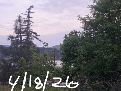
Glenwood this morning
It’s Saturday morning, and Glenwood (of course) is below freezing: 30F. Up in Parkdale, temps range from 32-35F this morning. The rest of us are generally running 35-40F, except Centerville, where they’re almost as cold as Glenwood but not quite: 31F.
Today’s Gorge weather forecast
This morning’s cloud cover mostly dissipates by afternoon. We’re left with mostly clear sky. Lowland temps range form 69F to the west and 72F out in the desert. East wind will be 20-30mph this morning near Iwash (cock) Rock and Stevenson. That wind fades to 10-15mph this afternoon. For the rest of us: light wind.
Sunday’s Gorge weather forecast
Sunday looks very similar in some ways: mostly cloudy sky most of the day, similar strength easterlies in the western Gorge, warm temps. Differences: easterlies rise to 10-15mph in the hills and areas away from the Nch’i Wana, and temps rise to 73-77F. Oh, and the clouds last longer. Okay, there are lots of difference between Saturday and Sunday’s weather, but both days will still be part of the weekend!
Monday’s Gorge weather forecast
Warm, overcast weather continues on Monday. After a 50F start (WARM) for many of us, temps rise to 75F in the west and nearly 80F from The Dalles eastward. For most of the day, we’ll have light/variable wind. Late in the day, an offshore low pressure system makes a move inland. This results in cooling temps and the potential for strong west wind, especially overnight.
Extended Gorge weather forecast
Uncertainty skyrockets in the Tuesday-Wednesday time frame. Generally speaking the weather turns a bit cooler and windier, but the timing of that change is unclear. By Wednesday, high temps will likely be below 60F. Rain is possible. Beyond that, a fair bit of uncertainty exists, but the weather is almost certain to be relatively warm (60+ degrees) and mostly dry through the first few days of May with very low chance of any frost nights. Good. I’ll be on a two-week retreat, and my housesitter will be very excited for the nice Gorge weather. Safe travels. -TATAS
HEY! DON’T STOP READING! Is this community-focused forecast helpful to you? It sure is! It takes me a couple hours a day to write. Please join your friends and neighbors in contributing to keep it going. Venmo: @thegorgeismygym PayPal: twomirrors@gmail.com USPS: Temira / PO Box 841 / Hood River, Oregon 97031 You can test out the forecast subscription for a few days for free by signing up below. Easy! Do it!
JONES BEACH, SAUVIE ISLAND, & COAST FORECAST
ON WINTER VACATION UNLESS DESPERATELY NEEDED.
