

GORGE WIND FORECAST
If you’re still seeing yesterday’s and it’s after 9am, try opening this in an incognito window
SHORT-TERM gorge wind forecast

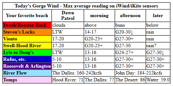
Hi friends! Today’s not quite the cooldown we were looking for, but the Gorge wind forecast has enough to get us on the river! Lesser westerlies are in the cards on Tuesday, but we’ll return to our regularly scheduled 20+ mph on Wednesday. It’s likely we’ll be plagued by atmospheric instability Tuesday through Thursday – expect gusty and unreliable conditions (perfect for paddling, the sport that doesn’t care about wind quality!). Friday’s forecasts continue to suggest a cooler system will drop down from Alaska and drive stronger westerlies. Fingers crossed this forecast holds – the Euro ensemble certainly likes our chances! Ok, before I really dive in, I want to express my deepest gratitude to the guy who hooked me up with an amazing new DW SUP board for a really good price. I so appreciate your generosity and kindness and will pay it forward!
Monday started with pressures of 29.80/29.78/29.76 and a cold low approaching off the coast. Wind wasn’t doing much at all as I started typing, but it was already at 17-20 (Viento to the Hatch) by the time I finished. As this system approaches with cool air, and the desert heats up, we’ll see the wind build. By late morning, Stevenson-Rufus should be at 20-23mph. In the afternoon, the cold front pushes rain into the western Gorge. Ahead of this front, wind speeds should jump dramatically. We’re expecting gusty 25-28+ from Stevenson to Rufus by mid-afternoon with the potential for 27-30mph. Viento tends to over-perform in this situation, and the Hatch tends to be very gusty. Looking at the sounding model, there is some potential for surface-based instabilty; if it manifests, the wind won’t cooperate. Don’t vote for that, okay?
As the rain pushes farther east (to Hood River, and also from Wishram to Biggs) late afternoon, the wind does too. We finish up with 27-30mph from Viento to Threemile. Expect very gusty conditions in the Rufus section, but hey, at least the current is down! River flow over the last 24 hours was 160-242kcfs (184-212 at Rufus). River temp was 59.0F. High temp forecast is 71F in Hood River and 86F in the desert – that huge difference is really going to help wind speeds this afternoon! One last thing – this is not an ideal setup. Sometimes the big wind associated with these cold fronts doesn’t pan out, and there doesn’t see to be a lot of logic to when it’s good / not good. So, it’s possible the wind could end up being a lot lighter than the forecast above. For the highest chance of success, get right ahead of that incoming cold front for a 60-90 minute near-guaranteed blast.
RIVER FLOW FOR SITES BETWEEN AVERY (EAST OF THE DALLES) AND RUFUS: CLICK HERE FOR JOHN DAY DAM FLOW.
RIVER FLOW FOR SITES BETWEEN STEVENSON AND DOUG’S BEACH (WEST OF THE DALLES): CLICK HERE FOR THE DALLES DAM FLOW

LONGER-TERM gorge wind forecast
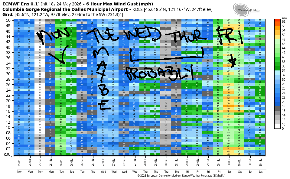
Tuesday sees us under cool air aloft with showery conditions at the surface. We start the day with 7-10mph west of The Dalles and 10-13mph east of The Dalles. Afternoon wind builds to 19-22mph from Lyle to Rufus with 10mph or less to the west and east of that zone. High temp: 65-68F.
On Wednesday, we’ll have a bit of a chaotic setup: wind aloft will be easterly, and wind at the surface will be westerly. This results in widespread instability with possible disruption to the wind. Even so, we’ll have high pressure offshore and a deep heat low in Montana combining for synoptic-scale assistance for the westerlies. For now, let’s call it 24-27mph from Viento to Mosier in the morning with 18-22mph east of Mosier all the way to Arlington. Afternoon: mid 20s as far east as Doug’s with teens to the east. This is highly likely to change!
Significant instability is forecast by about 70% of the euro ensembles for Thursday, which isn’t a great sign for wind. That said, the models also call for more wind than Wednesday. So… we shall see. All eyes then turn to Friday when an approaching trough/cold front combines with a heat low in the desert and offshore high pressure for a potentially nuking west wind day. If you trust in the Euro, solid westerlies continue through at least Saturday. Let’s leave it there for now. See you on the Nch’i Wana this afternoon!

Was that helpful? I knew it was! Guess what? All of this crucial work – from your personal wind and snow reports to the invaluable TATAS updates – is made possible by my relentless efforts. Maintaining this labor of love isn’t easy. Each daily forecast takes hours. Website hosting, weather model access, and back-end admin work takes time and money. That’s where you come in.
YOUR CONTRIBUTION MAKES A DIFFERENCE
- SUPPORT ACCURATE, HYPER-LOCAL WEATHER FORECASTING
- ENABLE ACCESS FOR ALL, EVEN THOSE WITH LESS MEANS
- SUPPORT A COOL HUMAN WHO WORKS HARD SO YOU CAN PLAY
Take a moment to click one of the buttons below. Donate $19.99 or more (how much does this forecast enhance your life?) and get the email in your inbox. Whether it’s a renewing subscription (auto-renew) or a one-time donation, every contribution makes a real difference. Help me keep this labor of love alive, so we can all continue playing, commuting, and living in the Gorge with peace of mind and the best weather forecasts possible. Thank you!


Hood River, Oregon 97031


JONES BEACH, SAUVIE ISLAND, & COAST FORECAST
Wind northerly unless otherwise indicated. For coast, it’s North/Central/South with the “central” at approximately Florence. Swell forecast from NWS for central coast. Jones: westerly unless otherwise stated. Sauvie Island: northerly unless otherwise stated.
Coast Monday: SW15-20/SW15/LTV, W swell 9′ @ 13 seconds and SW 6′ @ 6. Tuesday: NNW15/NNW15/N20, W 14′ @ 15. Wednesday: NNW10-15/NNW10/N15, NW 7′ @ 11. Jones Monday: LTW. Tuesday: 11-14. Wednesday: 17-20. Sauvie Island Monday: SW15. Tuesday: instability will mess it all up. Wednesday: NW 5-10.
BARE BONES HOOD RIVER WEATHER FORECAST
High clouds this morning. Increasing clouds later with a chance of rain after 5pm. Temps start in the low 60s and rise to the low 70s. Light west wind early. Strong later. 15% chance of rainbows. Tuesday will be cloudy with showers then partly cloudy. Temps start in the mid 40s and rise to the mid 60s. Light westerlies. 98% chance of rainbows. Wednesday might be rainy early, and it might not. It will be cloudy. We might see thundershowers in the afternoon. Temps start in the mid 40s and rise to the low 70s. Moderately strong to strong westerlies. 18% chance of rainbows.
TEMIRA’S AWESOME TRAVEL ADVISORY SERVICE
HYPERLOCAL WEATHER FORECAST FOR THE COLUMBIA GORGE
THE DALLES, HOOD RIVER, WHITE SALMON, TROUT LAKE, STEVENSON, CASCADE LOCKS, PARKDALE, ODELL, HUSUM, BZ, MILL A, WILLARD, GOLDENDALE, RUFUS, ARLINGTON, boardman
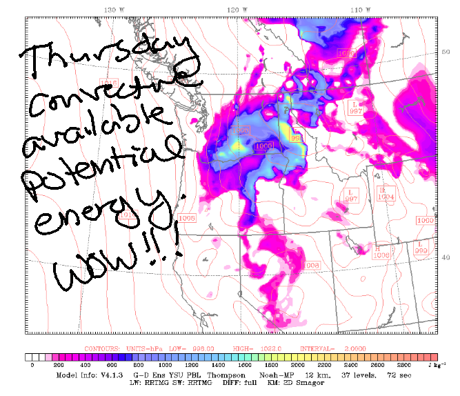
Good morning, neighbors! Been bored with the weather lately? You’ll be bored no more – change is in the air (literally) as a low pressure system comes to visit from Alaska. It’ll bring cooler temps, stronger wind, and a bit of rain for some of us this week. Temps do climb again into Friday, but they’ll probably drop off again next weekend. Thunderstorms are possible (but unlikely) on Tuesday or Wednesday, and there’s a more likely chance of thunder on Thursday.
Glenwood, Tehran, and Havana this morning
Checking in with our friends this morning… we started the day tied for the record high-low in Hood River at 59 degrees. Glenwood was 50. The forecast for our fellow human beings in Tehran is 84 degrees with 11% humidity, and the forecast for our friends in Havana is 81 degrees and 76% humidity.
Today’s Gorge weather forecast
Our Gorge weather forecast contains increasing clouds today as a cold front approaches. After 2pm, it starts raining west of Viento, and it’ll probably rain hard enough to impact the evening commute (call it “moderate” rainfall). By 5pm, drizzle makes it to Hood River with drizzle between Wishram and Biggs. Overnight: a round of heavy rain passes through areas south and east of The Dalles. Temps today range from 68F in Stevenson to 71 in Hood River, 77 in The Dalles, and 86 in Pasco. In a fun twist, today’s system will drive the snow level down to 4000′ by Tuesday morning! Wind today: light westerly to start with westerlies at 25-35mph all the way from Stevenson to Hermiston this afternoon and evening.
Tuesday’s Gorge weather forecast
Tuesday kicks off with drizzle as far east as Stevenson and also rain out near the Tri Cities. Intermittent showers pop up during the day thanks to instability. This results in a high chance of rainbows. Hide your children. Rainbows cause people to tumble into the LGBTQ+ family (like me – I’m queer because I saw too many rainbows). Tuesday morning temps start in the 40-47F range and rise to 62F (Stevenson), 65F (Hood River), and 68F (The Dalles eastward). Wind will be 10mph to start. It rises to 20mph between Lyle and Rufus with 10mph to the east and west. Snow level: 4000′ rising to 5500′.
Extended Gorge weather forecast (watch out for thunderstorms Thursday!)
For Wednesday, we’ll have instability, a chance of thunder, and the potential for some early-morning wraparound moisture. Maybe. Wraparound moisture would be awesome. ANY rain would be awesome! After a mid-40s start, temps rise to 70-78F. West wind will be in he 20-25mph range all the way from Stevenson to Rufus. Thursday looks warmer and rather interesting thanks to instability – thunderstorms are possible. Wind: 20-25mph. Temps: 75-86F after a warm start.
Models suggest a cooler system will drop down from Alaska on Friday and repeat Memorial Day’s weather: windy with a chance of rain. Let’s leave it there for now. I’m still not awake, my coffee isn’t working, and I’m going to take more drastic measures – energy drink, here I come! Safe travels. -TATAS
HEY! DON’T STOP READING! Is this community-focused forecast helpful to you? It sure is! It takes me a couple hours a day to write. Please join your friends and neighbors in contributing to keep it going. Venmo: @thegorgeismygym PayPal: twomirrors@gmail.com USPS: Temira / PO Box 841 / Hood River, Oregon 97031 You can test out the forecast subscription for a few days for free by signing up below. Easy! Do it!
MT HOOD SNOW FORECAST

QR codes and links for end-of-season tips – thank you!!!
Cash/check: Temira – PO BOX 841 – Hood River, Oregon 97031