

GORGE WIND FORECAST
If you’re still seeing yesterday’s and it’s after 9am, try opening this in an incognito window
SHORT-TERM gorge wind forecast
Hi friends! Nice to see you all at the Hatch yesterday. There certainly is a fun mix of floating objects in the river: windsurfers, SUP foilers, trash baggers, E-foilers, wingers, a kiter, and probably some others I missed! We’ll have more opportunities in the Gorge wind forecast this week to make a floating-object salad and new floating-object friends. This opportunity starts today, Monday, with another round of mid-20s westerlies.
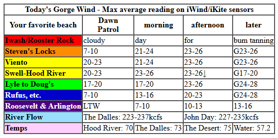
Early pressures Monday were 30.27/30.16/20.15 for gradients of 0.11/0.01. Offshore: 1028mb for added support. High clouds are indicative of a weather system moving into BC and suggest somewhat gusty, unreliable conditions today. TJ and Eddy’s Dawn Patrol was 20-23mph from Viento to the Hatch with 13-16mph near Rowena and under 10mph pretty much everywhere else. Westerlies hold at 21-24mph this morning from Viento to the Hatch and fill in from Stevenson to Doug’s late morning.
With the approach of this system this afternoon and the dissipation of low clouds in the metro area, we’re likely to see the Hatch drop to 17-20mph. Elsewhere in the Stevenson to Rufus zone, the wind rises to gusty 24-28mph after 2pm and continues into the evening. Arlington eventually builds to 13-16mph. River flow over the last 24 hours was 223-237kcfs, river temp is 57.2F, and high temp forecast is 70F for Hood River and 75F in the desert.
RIVER FLOW FOR SITES BETWEEN AVERY (EAST OF THE DALLES) AND RUFUS: CLICK HERE FOR JOHN DAY DAM FLOW.
RIVER FLOW FOR SITES BETWEEN STEVENSON AND DOUG’S BEACH (WEST OF THE DALLES): CLICK HERE FOR THE DALLES DAM FLOW

LONGER-TERM gorge wind forecast
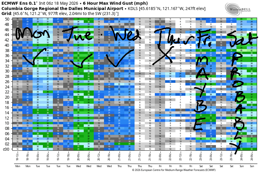
Tuesday sees the previously mentioned weather system move inland to WA/BC. High pressure builds offshore behind it late in the day, probably not early enough to settle things down and give us steadier wind. But maybe we’ll get lucky! So… expect 15-18mph from Stevenson to the Hatch to start with 7-10mph from Hood River to Arlington. The wind slowly builds to 21-24mph from Stevenson to Avery with 14-17mph at Rufus by early afternoon. Swell-Hood River are likely to under-perform in the morning. If things can stabilize early enough, we’ll see 20-23mph from Stevenson to Hood River from mid-afternoon on with 25-28mph from Mosier to Rufus and 20-23mph at Arlington. High temp: 72F in Hood River with partly cloudy sky in the morning and mostly sunny later.
Wednesday brings a less “active” weather day with a decent chance for reality to exceed the models. Those models call for 13-16mph near the Hatch in the morning with 20-23mph from Stevenson to Mosier and 17-20mph near Rowena in the afternoon. Fingers crossed for reality to exceed expectations! High temp: 78F.
Model agreement falls apart on Thursday with the GFS calling for little to no wind and the NWS automated forecast calling for “breezy” conditions. The Euro isn’t ‘much help here due to low resolution. Gut instinct says it’s going to be a bit warm in the metro area for significant wind in the Gorge – you’ll be better served at Jones Beach or the Coast. Forecast for now: under 15mph. As of this morning, models suggest stronger wind is possible on Friday and likely on Saturday and possible again on Sunday. Looks like a great week of wind, eh? See you on the Nch’i Wana soon!

Was that helpful? I knew it was! Guess what? All of this crucial work – from your personal wind and snow reports to the invaluable TATAS updates – is made possible by my relentless efforts. Maintaining this labor of love isn’t easy. Each daily forecast takes hours. Website hosting, weather model access, and back-end admin work takes time and money. That’s where you come in.
YOUR CONTRIBUTION MAKES A DIFFERENCE
- SUPPORT ACCURATE, HYPER-LOCAL WEATHER FORECASTING
- ENABLE ACCESS FOR ALL, EVEN THOSE WITH LESS MEANS
- SUPPORT A COOL HUMAN WHO WORKS HARD SO YOU CAN PLAY
Take a moment to click one of the buttons below. Donate $19.99 or more (how much does this forecast enhance your life?) and get the email in your inbox. Whether it’s a renewing subscription (auto-renew) or a one-time donation, every contribution makes a real difference. Help me keep this labor of love alive, so we can all continue playing, commuting, and living in the Gorge with peace of mind and the best weather forecasts possible. Thank you!


Hood River, Oregon 97031


JONES BEACH, SAUVIE ISLAND, & COAST FORECAST
Wind northerly unless otherwise indicated. For coast, it’s North/Central/South with the “central” at approximately Florence. Swell forecast from NWS for central coast. Jones: westerly unless otherwise stated. Sauvie Island: northerly unless otherwise stated. Coast Monday: 10-15/15-20/30-35, NW swell 7′ at 10 seconds. Tuesday: 10-15/15-20/30-35, NW 7′ @ 14. Wednesday: 15-20/20-25/30-40, NW 6′ @ 12. Jones Monday: 18-21. Tuesday: 7-10. Wednesday: 15-18. Sauvie Island Monday: 11-14. Tuesday: NW 10-13. Wednesday: 15-18.
BARE BONES HOOD RIVER WEATHER FORECAST
High clouds this morning. Mostly clear later. Temps start in the low 50s and rise to 70. Moderately strong westerlies. No rainbows. Tuesday will be partly cloudy. Temps start in the low 40s and rise to the low 70s. Moderate westerlies early. Moderately strong westerlies later. No rainbows. Wednesday will be partly cloudy then mostly clear. Temps start in the upper 40s and rise to the upper 70s. Light westerlies early. Moderate westerlies late in the day. No rainbows.
TEMIRA’S AWESOME TRAVEL ADVISORY SERVICE
HYPERLOCAL WEATHER FORECAST FOR THE COLUMBIA GORGE
THE DALLES, HOOD RIVER, WHITE SALMON, TROUT LAKE, STEVENSON, CASCADE LOCKS, PARKDALE, ODELL, HUSUM, BZ, MILL A, WILLARD, GOLDENDALE, RUFUS, ARLINGTON, boardman
Good morning, neighbors! Rather mild, rather unexciting, dry weather is on tap for this entire week. A slight chance of rain pops up next weekend. By slight, I mean as slight as someone who has bought into the patriarchy’s idea that women should be skinny and slight and obsessed with how they look (because that keeps them busy with their body-based shame instead of rebelling against the system). Frost is about as likely this week as the fall of the patriarchy this week, but we can hope for the latter while appreciating the former!
Glenwood this morning & today’s Gorge weather forecast
Let’s catch up with Glenwood. The sensor is back online and reporting 33F this morning. According to someone in the Hood River Weather chatroom, Glenwood bottomed out at 27F yesterday. Bottoming out is different than bottoming and not nearly as fun. Parkdale and Dufur are both reporting 37-40F this morning. So, all is good in the Gorge. Temps today rise to 70F in Hood River, 73F in The Dalles, and 75F in the desert. We’ll have high clouds this morning, clear sky midday, and partly cloudy sky this afternoon. West wind starts at 20mph from Viento to Hood River and rises to 25mph from Stevenson to Rufus this afternoon with 15mph near Arlington’s equilateral triangle. This is not the biggest triangle in the world. According to AI, that honor goes to the “Bermuda Triangle”. And this goes to show how ridiculous AI can be, because “what is the biggest triangle in the world” is a completely non-nonsensical question!
Tuesday’s Gorge weather forecast
Speaking of nonsensical, Tuesday morning starts with temps in the 40-49F range with a few scattered upper 30s. Sky will be cloudy west of Hood river and partly high overcast elsewhere, so keep your camera handy for sunrise at 5:37am. . Morning wind will be 15-20mph between Viento and Mosier with 5-10mph east into the desert. Afternoon wind rises to 20-25mph from Stevenson to Hood River with 25-30mph from Mosier to Rufus and 20-25mph to Arlington. Highs range from 66F (Cascade Locks) to 72F (HR), 75 (TD), and 78F (Pasco). FYI, my cat has the zoomies right now.
Wednesday’s Gorge weather forecast
Wednesday starts with clouds to the west and partly cloudy sky to the east with temps in the 40-50F range. Afternoon will be partly high overcast, which gives us a decent chance for a pretty sunset. Temps rise to 69F (CL) to 78-80F (HR to the desert). Wind will be 15mph west of Mosier and calm east of Mosier to start. Afternoon: 20-25mph from Stevenson to Mosier with 15-20mph near Rowena and less than 15mph to the east.
Extended Gorge weather forecast
Your best chance for a light wind day to Get Shit Done is Thursday, although west wind is likely to pick up in the afternoon. Model agreement starts to fall apart on Friday, when it might stay as warm as Thursday, and it might start to cool off. Between Saturday and Monday, we’ll lose 10-20F off the high temps. Add in a chance of rain in that window – about 80% chance for Cascade Locks and 30% for The Dalles. Rain chances for areas west of Mosier continue into next week, but model uncertainty is quite high about precipitation, temps, and the answer to life, the universe and everything.
Best answer I have: get out and do some gardening. It’s good for the soul. If you don’t have a garden and want one, find a community garden or ask someone with land! Looking at the extended forecast, there’s some chance temps at 850mb will dip as low as 0C next week which could put Glenwood and Dufur at risk for frost. But that’s a long ways out to be making predictions, and also, we’re approaching the time of year when short nights make frost increasingly unlikely. I’m gonna plant corn and peppers and basil today. You do you, boo. Safe travels. -TATAS
HEY! DON’T STOP READING! Is this community-focused forecast helpful to you? It sure is! It takes me a couple hours a day to write. Please join your friends and neighbors in contributing to keep it going. Venmo: @thegorgeismygym PayPal: twomirrors@gmail.com USPS: Temira / PO Box 841 / Hood River, Oregon 97031 You can test out the forecast subscription for a few days for free by signing up below. Easy! Do it!
MT HOOD SNOW FORECAST

QR codes and links for end-of-season tips – thank you!!!
Cash/check: Temira – PO BOX 841 – Hood River, Oregon 97031


