

GORGE WIND FORECAST
If you’re still seeing yesterday’s and it’s after 9am, try opening this in an incognito window
SHORT-TERM gorge wind forecast
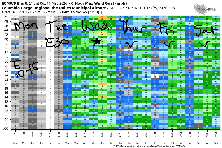
Hi friends! Fun playing on the Nch’i Wana with you yesterday! Not much happens today on the river, but I bet you can find some other fun things to do! Easterlies pick up just enough to get you on the river on Tuesday, and if we get lucky, westerlies will return late in the day. The Cooldown You’ve Been Looking For arrives on Wednesday with potential for a big, big west wind day. Westerlies continue Thursday and Friday as cool weather lingers. Beyond that, model uncertainty rises, but most ensemble members give us westerlies through the weekend.
Looking at Monday morning, we have light onshore gradients to start the day (30.18/30.13/30.15), but hot weather in the Valley of Willies (Willamette Valley) will turn the wind easterly. Peak wind will be late morning at Stevenson (15mph) and Iwash/Rooster Rock (10mph). The wind equalizes at 10mph in the afternoon. Areas east of Viento will be less than 10mph all day. River flow over the last 24 hours was 211-257kcfs (238-257 at Rufus), river temp is 57.4F, and high temp forecast is 79F and sunny.
RIVER FLOW FOR SITES BETWEEN AVERY (EAST OF THE DALLES) AND RUFUS: CLICK HERE FOR JOHN DAY DAM FLOW.
RIVER FLOW FOR SITES BETWEEN STEVENSON AND DOUG’S BEACH (WEST OF THE DALLES): CLICK HERE FOR THE DALLES DAM FLOW

LONGER-TERM gorge wind forecast
The west side heat low dominates the picture for most of Tuesday. East wind results. If we’re lucky, a trough approaching in the afternoon will nudge the heat low to the desert and give us late-day westerlies. Morning wind will be 30mph at Iwash/Rooster and 25mph at Stevenson. The wind fades late morning and leaves us with 20-25mph by early afternoon. Calm conditions hold for a few hours in the late afternoon, and might be replaced by west 17-20mph (Stevenson to Doug’s) for the Executive Session (after 5pm). High temp: 86F under mostly clear sky.
Overnight into Wednesday, westerlies skyrocket. We’re left with (TJ and Eddy’a) Dawn Patrol of 25-28mph from Stevenson to Doug’s with 13-16mph into the desert. The wind just builds and builds. Expect 30+ mph on the west side sensors (which read low compared to the desert), and 35mph on the sensors from Rowena east to Arlington. Farther east, the wind will be less. High temp: 72F in Hood river and 82F in the desert with partly cloudy sky.
Uncertainty climbs Thursday and Friday and Saturday, but models do call for moderate to moderately strong westerlies. Numbers would probably be more helpful, eh? There’s too much uncertainty for clear predictions, but it’s almost certain we’ll see 17-20mph or more. Temps will be cooler – in the 65-75F range. It’s even possible we could see a little rain in there. This is looking like a solid week of wind. I’m looking forward to joining you on the Nch’i Wana! See you out there soon!

Was that helpful? I knew it was! Guess what? All of this crucial work – from your personal wind and snow reports to the invaluable TATAS updates – is made possible by my relentless efforts. Maintaining this labor of love isn’t easy. Each daily forecast takes hours. Website hosting, weather model access, and back-end admin work takes time and money. That’s where you come in.
YOUR CONTRIBUTION MAKES A DIFFERENCE
- SUPPORT ACCURATE, HYPER-LOCAL WEATHER FORECASTING
- ENABLE ACCESS FOR ALL, EVEN THOSE WITH LESS MEANS
- SUPPORT A COOL HUMAN WHO WORKS HARD SO YOU CAN PLAY
Take a moment to click one of the buttons below. Donate $19.99 or more (how much does this forecast enhance your life?) and get the email in your inbox. Whether it’s a renewing subscription (auto-renew) or a one-time donation, every contribution makes a real difference. Help me keep this labor of love alive, so we can all continue playing, commuting, and living in the Gorge with peace of mind and the best weather forecasts possible. Thank you!


Hood River, Oregon 97031


JONES BEACH, SAUVIE ISLAND, & COAST FORECAST
Wind northerly unless otherwise indicated. For coast, it’s North/Central/South with the “central” at approximately Florence. Swell forecast from NWS for central coast. Jones: westerly unless otherwise stated. Sauvie Island: northerly unless otherwise stated. Coast 20-25/20-25/30, W swell 5′ at 11 seconds. Tuesday: LTW/LTW/LTV, W 5′ @ 12. Wednesday: NW 10-15/W10/LTV, W 6′ @ 12. Jones Monday: LTE. Tuesdsay: 20-23. Wednesday: 23-26. Sauvie Island Monday: 15-18. Tuesday: calm. Wednesday: 10.
BARE BONES HOOD RIVER WEATHER FORECAST
Clear all day. Temps start in the upper 40s and rise to the upper 70s. Light easterlies. No rainbows. Tuesday will be mostly clear. Temps start in the low 50s and rise to the mi d80s. Light to moderate easterlies. No rainbows. Wednesday will be partly cloudy. Temps start in the mid 50s and rise to the low 70s. Strong westerlies. No rainbows.
TEMIRA’S AWESOME TRAVEL ADVISORY SERVICE
HYPERLOCAL WEATHER FORECAST FOR THE COLUMBIA GORGE
THE DALLES, HOOD RIVER, WHITE SALMON, TROUT LAKE, STEVENSON, CASCADE LOCKS, PARKDALE, ODELL, HUSUM, BZ, MILL A, WILLARD, GOLDENDALE, RUFUS, ARLINGTON, boardman
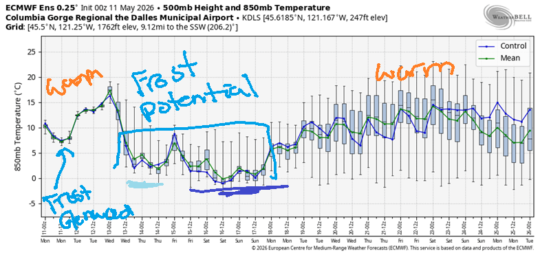
Good morning, neighbors! It’s a beautiful start to the day – sunny and clear. Not much changes from that other than the thermometer reading. Warmer weather is forecast on Tuesday. We then tumble into a cooler pattern starting Thursday and potentially continuing into the weekend. Temps aloft look cold enough Saturday and Sunday to put some of us at risk of frost. More on that later…
Glenwood this morning and today’s Gorge weather forecast
Speaking of frost… yeah, Glenwood had some this morning – it was 32 degrees there to start the day. Also in the cold club: the northern part of the Upper Valley, with 36F to start the day. By afternoon, we’ll all be sitting pretty with high temps near 80 degrees. Wind will be calm this morning and light easterly from late morning on. Peak wind will be in the usual spots – Dick Rock and Stevenson – at 10-15mph.
Tuesday’s Gorge weather forecast
Tuesday brings a few high clouds and 10 more degrees of heat – highs will be 85-90 west of Mosier and right around 90 from The Dalles eastward. HOT! TOO HOT! Tuesday’s record high in Hood River is 94F, so we’re unlikely to set a record, but this is still unseasonably warm. Other Tuesday news: east wind at 25-30mph near Iwash (schlong) Rock and Stevenson in the morning, calm for a bit in the afternoon, and west wind at 15-20mph from Stevenson to The Dalles in the evening.
Wednesday’s Gorge weather forecast
Overnight, we’ll have strong west wind as a cooler system approaches the area. Given the wind and partly cloudy sky to start, morning temps will be in the mid 50s. High temps on Wednesday will be down 10-20 degrees from Tuesday which puts us in the upper 60s to low 70s on the west side and low 80s east of The Dalles. If you’ve lived here a while, you know how this plays out in terms of wind: it’s going to be very, very windy on Wednesday, 30+ mph all through the Gorge. Thank the stars it isn’t super dry yet, because the potential for wildfire spread would be high. If it happens to be super-dry where you are, please be very careful with sparks and flames.
Extended Gorge weather forecast and frost discussion
Cooler, windy weather continues through the end of the week with a slight chance of some sprinkles here and there. We’ll talk more about that when models are more certain.
Now, let’s talk about frost potential. Starting Wednesday, temps at 850mb (~5000′) drop below +3C, and those temps have the potential to fall below 0C for the weekend. With clear sky and calm wind, frost would be certain. As of this morning, the forecast calls for wind and at least partly cloudy sky and some chance of precipitation. All those factors are working in our favor to prevent frost. Still, given the overall setup and unseasonably cool temps, I’d recommend keeping your guard up. If you haven’t yet put sensitive plants in the ground, especially if you’re at elevation, consider delaying until after next weekend. I already planted tomatoes, so I’m F’ed there, but I’m going to postpone planting peppers until after the weekend. I recommend you do the same. Happy growing. Safe travels. -TATAS
HEY! DON’T STOP READING! Is this community-focused forecast helpful to you? It sure is! It takes me a couple hours a day to write. Please join your friends and neighbors in contributing to keep it going. Venmo: @thegorgeismygym PayPal: twomirrors@gmail.com USPS: Temira / PO Box 841 / Hood River, Oregon 97031 You can test out the forecast subscription for a few days for free by signing up below. Easy! Do it!
MT HOOD SNOW FORECAST

QR codes and links for end-of-season tips – thank you!!!
Cash/check: Temira – PO BOX 841 – Hood River, Oregon 97031


