

MT HOOD SNOW FORECAST

QR codes and links for end-of-season tips – thank you!!!
Cash/check: Temira – PO BOX 841 – Hood River, Oregon 97031


Hey skiers and snowboarders! It’s been fun spending ski season with you! This is the last snow forecast of the year – the other forecasts will continue all summer. Snow forecasting returns sometime in November depending on what the weather is doing. If this has been valuable for you over the last six months, please do take the time to leave an end-of-season tip (which I will spend on summer sport gear and the peace & non-violence chaplaincy training I just got accepted to!)
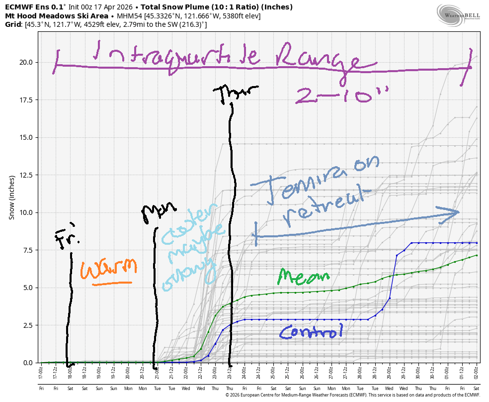
Short term Mt Hood snow forecast
Friday on Mt. Hood brings sunshine in the morning and sun filtered through high clouds in the afternoon. The free air freezing level will be 1000-1500′ to start the day, 5000′ in the afternoon, and 7000′ to finish. Snow surface will be hardpack on the groom. Off the groom, I’m guessing we’ll have a sun crust despite the cold temps – April sunshine is pretty strong. Temps max out in the mid to upper 30s today at 5000′. Wind will be NW 10-15 early, light westerly this afternoon, and SW 10-15 after midnight.
Notes… Nordic skiers: Teacup did some snowmobile grooming the last couple of mornings. No post yet from them today. No report either from ODOT on road conditions, but it does look like they did some deicing on 35 (towards Parkdale) from their station that’s south of Parkdale. Expect icy roads.
Extended Mt Hood Snow Forecast
Saturday’s sky will be tainted by high clouds, but the sun will filter through. The free air freezing level (FAF) will be 7000′ in the morning, 85000′ in the afternoon, and 10,000′ after midnight. Temps max out around 50F at 5000′. Wind will be SW or S 5-15mph all day and all night.
Sunday will be cloudy to start then high overcast. The FAF hovers around 10,000′ for the 24 hour period with temps maxing out around 50F at 5000′. Wind will be S 10-15 all day and E 15-20 overnight.
As we move into next week, uncertainty skyrockets. Models are pretty certain Monday will be dry and warm. There’s some indication of precipitation (probably rain, but possibly snow) in the Tuesday-Wednesday time period. After next Thursday, the weather warms up and turns dry again. Have a wonderful summer, everyone! Here’s to a snowier winter next year… and please do leave a tip if you’ve found this forecast helpful this winter!
Was that helpful? I knew it was! Guess what? All of this crucial work – from your personal wind and snow reports to the invaluable TATAS updates – is made possible by my relentless efforts. Maintaining this labor of love isn’t easy. Each daily forecast takes hours. Website hosting, weather model access, and back-end admin work takes time and money. That’s where you come in.
YOUR CONTRIBUTION MAKES A DIFFERENCE
- SUPPORT ACCURATE, HYPER-LOCAL WEATHER FORECASTING
- ENABLE ACCESS FOR ALL, EVEN THOSE WITH LESS MEANS
- SUPPORT A COOL HUMAN WHO WORKS HARD SO YOU CAN PLAY
Take a moment to click one of the buttons below. Donate $19.99 or more (how much does this forecast enhance your life?) and get the email in your inbox. Whether it’s a renewing subscription (auto-renew) or a one-time donation, every contribution makes a real difference. Help me keep this labor of love alive, so we can all continue playing, commuting, and living in the Gorge with peace of mind and the best weather forecasts possible. Thank you!


Hood River, Oregon 97031


GORGE WIND FORECAST
If you’re still seeing yesterday’s and it’s after 9am, try opening this in an incognito window
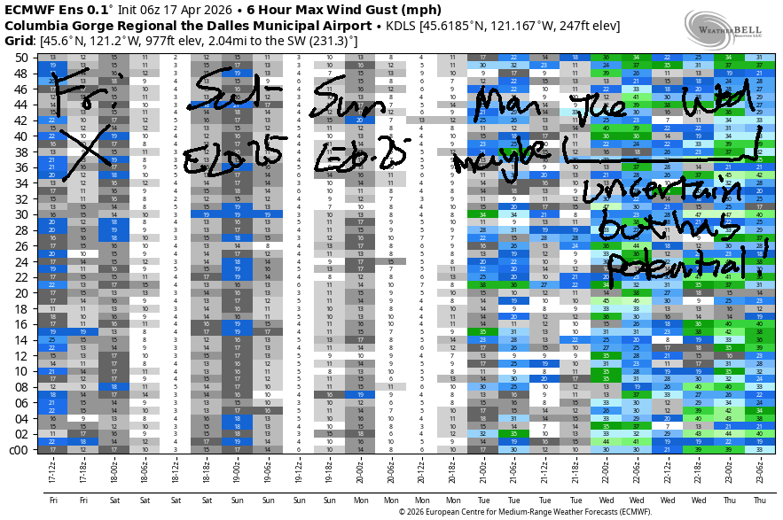
SHORT-TERM gorge wind forecast
Hi friends! It’s another beautiful morning in the Gorge. We’re set for a light wind day today (Friday) followed by moderate easterlies for the weekend. Uncertainty climbs starting Monday. There is some indication of solid west wind Tuesday and Wednesday, but models are far from agreeing on the details.
Friday kicked off with pressures of 30.34/30.29/30.26 for moderate onshore gradients. Westerlies at dawn were generally 7-10mph all through the Gorge. Given the gradients and presence of clouds, a couple hours of 12-15mph wind from Viento to Hood River seems possible early this morning. By midday, models take the wind below 10mph all through the Gorge. River flow over the last 24 hours was 179-231kcfs, river temp is 50.7F, and high temp forecast is 61F and sunny.
RIVER FLOW FOR SITES BETWEEN AVERY (EAST OF THE DALLES) AND RUFUS: CLICK HERE FOR JOHN DAY DAM FLOW.
RIVER FLOW FOR SITES BETWEEN STEVENSON AND DOUG’S BEACH (WEST OF THE DALLES): CLICK HERE FOR THE DALLES DAM FLOW

LONGER-TERM gorge wind forecast
Saturday starts with easterlies at 25mph at Iwash (Rooster) Rock and 20-25mph at Stevenson. The wind holds for a couple hours in the morning before dropping to 10mph in the afternoon. High temp: 69F and partly high overcast. Sunday looks similar: 25mph to start at Stevenson and 15mph to start at Iwash. By 1pm, Stevenson drops to 15mph, and Iwash turns light westerly. Stevenson eventually picks up to W 10mph in the afternoon. High temp: 72F and partly to mostly cloudy.
Uncertainty increases as next week starts. Models are all over the place! For now, we’re looking at a light start on Monday with the possibility of upper teens to low 20s at the Hatch late in the day. Tuesday and Wednesday have potential, but it completely depends on the evolution and inland progression of an offshore low. Vote for the GFS deterministic which has nuking wind both days. Euro ensemble: far less optimistic. Heads up: I’ll be gone for two weeks starting the 24th and then hear every day until mid-August.

BARE BONES HOOD RIVER WEATHER FORECAST
Clear sky this morning. Increasing high clouds late. Temps start in the low 40s and rise to the low 60s. Light westerlies early. Calm wind later. No rainbows. Saturday will be partly high overcast. Temps start in the upper 30s and rise tot he upper 60s. Light easterlies. No rainbows. Sunday will be partly to mostly cloudy. Temps start in mid 40s and rise to the low 70s. Light easterlies most of the day. Light westerlies late. No rainbows.
TEMIRA’S AWESOME TRAVEL ADVISORY SERVICE
HYPERLOCAL WEATHER FORECAST FOR THE COLUMBIA GORGE
THE DALLES, HOOD RIVER, WHITE SALMON, TROUT LAKE, STEVENSON, CASCADE LOCKS, PARKDALE, ODELL, HUSUM, BZ, MILL A, WILLARD, GOLDENDALE, RUFUS, ARLINGTON, boardman
Good morning, neighbors! An absolutely PERFECT day is on tap: sunshine, light wind, and low 60s. Dry, mild weather persists through at least next Monday. Models indicate some possibility of moisture along with cooler temps for the middle of next week, but the details are unclear. Beyond that, warm weather returns and looks likely to stick around for a while.
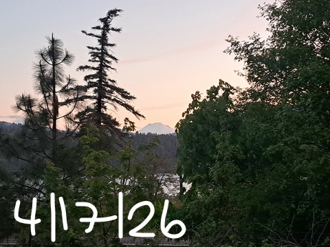
Glenwood this morning
It is NOT warm in Glenwood this morning. Every time I look, it’s colder. As of the writing of this forecast, it was 23 degrees. BRRR! If you multiple 23 by 3, you get 69, so that’s what everyone in Glenwood is doing this morning!
Today’s Gorge weather forecast
Elsewhere: Parkdale is surprisingly “warm” this morning at 30-33F. High Prairie, Centerville, Goldendale, and the Steele Road area of The Dalles are all reading 31F. I’m guessing it was breezier and/or a little cloudier than expected last night, because it really should be colder given the temps at 850mb: currently 19F! Well, I’m not complaining about the last of a hard freeze and nobody else is either! Speaking of freeze… it’s quite likely you’ll encounter icy conditions on the mountain passes today and potentially on some of the lower roads. Be careful out there!
Rest of Friday: clouds west of Hood River eventually burn off. The rest of us will be clear and sunny most of the day with increasing high clouds in the afternoon. That should set up a colorful sunset, yay. Lowland temps max out in the 61-63F range. West wind at 5-10mph this morning goes calm or nearly so by midday. This means it a PERFECT day to spend in the garden! (Also, TATAS will have rare/exotic tomato starts for sale again this year when they return from retreat around the 10th)
Saturday’s Gorge weather forecast
Saturday morning brings high clouds, light east wind, 850mb temps at +3C, and dewpoints from 22F (Mt. Hood Meadows) to 32F (Rufus). Low temps: Parkdale: 32-36F. Glenwood: 30-33F. Otherwise, temps should be in the mid 30s to low 40s. With extensive high cloud coverage early, we’re likely to have a gorgeous sunrise. That’s right around 6:21am. GET YOUR ASS OUT OF BED! At least a few high clouds linger into Saturday. This does not stop the warming: we’ll see 69F (west), 70F (The Dalles), and 72F (Pasco). Wind will be minimal most of the day at most places. Exceptions include the morning at Iwash (pen*s) Rock and Stevenson, where easterlies will be 25mph to start the day and 10mph to finish.
Sunday’s Gorge weather forecast
Cloudy, mild weather is forecast Sunday. Morning temps will be 40+ degrees most places, and 45+ degrees in many places. Temps rise to the low 70s (East Wind Drive-In line) to 74F (The Dalles bottle return line) and 78F (Amayah’s food cart line in Biggs). Wind will be E 15-25mph in the usual spots in the morning and light westerly in the afternoon. In the middle of the day, easterlies rise to 5-10mph most places.
Extended Gorge weather forecast
Warm, high overcast weather continues on Monday with highs in the 75-80F range. Wind will be light in the morning and may (or may not) pick up to 15-20mph in the afternoon. Model consensus falls apart Tuesday into Wednesday. If things line up just right (possibility 1) we could see thunderstorms. If they line up just right (possibility 2) we could see blasting west wind. If they line up just right (possibility 3, which doesn’t exclude 1 or 2) we could see some rain. Beyond the middle of next week, models have more certainty: relatively warm, probably dry weather. Safe travels. -TATAS
HEY! DON’T STOP READING! Is this community-focused forecast helpful to you? It sure is! It takes me a couple hours a day to write. Please join your friends and neighbors in contributing to keep it going. Venmo: @thegorgeismygym PayPal: twomirrors@gmail.com USPS: Temira / PO Box 841 / Hood River, Oregon 97031 You can test out the forecast subscription for a few days for free by signing up below. Easy! Do it!
JONES BEACH, SAUVIE ISLAND, & COAST FORECAST
ON WINTER VACATION UNLESS DESPERATELY NEEDED.
