

GORGE WIND FORECAST
If you’re still seeing yesterday’s and it’s after 9am, try opening this in an incognito window
SHORT-TERM gorge wind forecast
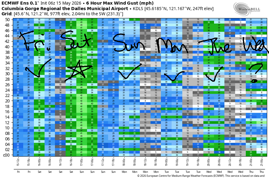
Hi friends! A long stretch of west wind is in the Gorge wind forecast. Saturday and Sunday are likely to be the strongest, but instability could impact wind quality especially on Saturday. Next week’s wind looks lighter, but still looks westerly.
Friday morning started with pressures of 30.21/30.13/30.08 for gradients of 0.08/0.05. A cold front is forecast to move inland this afternoon or evening. By mid-morning, the westerlies build to 14-17mph from Viento (Stevenson is likely to be drizzly and lighter) to Doug’s with 18-22mph from Avery to Boardman. In the afternoon, there’s a good chance of a short (60-90 minutes) pre-frontal burst of gusty 22-26mph from Viento to the Hatch or Hood River prior to the wind falling below 15mph with the arrival of drizzle as far east as Celilo.
After 2pm, areas east of Lyle get the same pre-frontal treatment: gusty 26-29mph from Avery to Arlington for a few hours with the wind eventually picking up to 20-23mph between Threemile and Boardman. River flow over the last 24 hours was 21-267kcfs (235-267 at Rufus), river temp is 57.7F, and high temp forecast is 60F in Hood River and 65F out east.
RIVER FLOW FOR SITES BETWEEN AVERY (EAST OF THE DALLES) AND RUFUS: CLICK HERE FOR JOHN DAY DAM FLOW.
RIVER FLOW FOR SITES BETWEEN STEVENSON AND DOUG’S BEACH (WEST OF THE DALLES): CLICK HERE FOR THE DALLES DAM FLOW

LONGER-TERM gorge wind forecast
The weather system clears the area early Saturday and leaves us with west-side clouds, offshore high pressure, a cross-Cascade temp gradient, and, unfortunately, widespread atmospheric instability. Areas east of Rufus will be most affected by the instability – keep that in mind for your decision making. Morning wind will be 7-10mph with intermittent showers west of Avery. Between Maryhill and Boardman, Saturday starts with 17-20mph. Thanks to continued showers and clouds, areas west of Mosier will probably stay light, under 15mph, but we can’t rule out the Hatch surprising us if clearing over-performs.
Head between Lyle (or maybe Avery) and Threemile for midday wind of 27-30mph. If instability really increases with afternoon warming, things could fall apart. If not, we have a good shot at decent-quality 30-33mph from Lyle to Rufus in the afternoon. East of Rufus: thunderstorms are more likely to impact your experience. High temp: 57F in Hood River and 65F out in the desert under partly cloudy sky.
Sunday starts with clouds to the west and clear sky out east with 16-19mph from Viento to Boardman. We’re expecting a cold start, which will lead to a slow build in the wind. By midday, we’ll have 18-21mph from Stevenson to Doug’s with 14-17mph from Avery to Boardman. Models suggest an afternoon build to 23-26mph from Mosier to Rufus with 14-17mph west of Mosier and also at Arlington. High temp: 63-68F.
Models take the wind down a few notches for Monday, Tuesday, and Wednesday, but we’re still likely to see 17-20mph or more. At least, that’s what the Euro ensemble says. It also hings at Stronger wind next Thursday. Beyond that, uncertainty increases, but there are hints of stronger wind (but vast uncertainty) next weekend. But I can’t recommend trusting a forecast that far out! See you on the Nch’i Wana soon!

Was that helpful? I knew it was! Guess what? All of this crucial work – from your personal wind and snow reports to the invaluable TATAS updates – is made possible by my relentless efforts. Maintaining this labor of love isn’t easy. Each daily forecast takes hours. Website hosting, weather model access, and back-end admin work takes time and money. That’s where you come in.
YOUR CONTRIBUTION MAKES A DIFFERENCE
- SUPPORT ACCURATE, HYPER-LOCAL WEATHER FORECASTING
- ENABLE ACCESS FOR ALL, EVEN THOSE WITH LESS MEANS
- SUPPORT A COOL HUMAN WHO WORKS HARD SO YOU CAN PLAY
Take a moment to click one of the buttons below. Donate $19.99 or more (how much does this forecast enhance your life?) and get the email in your inbox. Whether it’s a renewing subscription (auto-renew) or a one-time donation, every contribution makes a real difference. Help me keep this labor of love alive, so we can all continue playing, commuting, and living in the Gorge with peace of mind and the best weather forecasts possible. Thank you!


Hood River, Oregon 97031


JONES BEACH, SAUVIE ISLAND, & COAST FORECAST
Wind northerly unless otherwise indicated. For coast, it’s North/Central/South with the “central” at approximately Florence. Swell forecast from NWS for central coast. Jones: westerly unless otherwise stated. Sauvie Island: northerly unless otherwise stated. Coast Friday: WSW20-25/W15-20/N20-25, W swell 8′ @ 14 seconds. Saturday: NW20/NW15-20/N25-30, W 8′ @ 13. Sunday: NW10/N15-20/N30+, NW 7′ @ 11. Jones Friday: LTW. Saturday: 17-20. Sunday: 18-21. Sauvie Island Friday: W10. Saturday: NW 15-18. Sunday: N10-13.
BARE BONES HOOD RIVER WEATHER FORECAST
Partly cloudy this morning. Mostly cloudy with drizzle this evening. Temps start near 50 and rise to 60. Moderate westerlies. 61% chance of rainbows. Saturday will be cloudy and showery with a slight chance of thunderstorms. Temps start in the low 40s and rise to the upper 50s. Light westerlies. 98% chance of rainbows. Sunday will be cloudy then partly cloudy. Temps start around 40 and rise to the low 60s. Moderate to moderately strong westerlies. 1% chance of rainbows.
TEMIRA’S AWESOME TRAVEL ADVISORY SERVICE
HYPERLOCAL WEATHER FORECAST FOR THE COLUMBIA GORGE
THE DALLES, HOOD RIVER, WHITE SALMON, TROUT LAKE, STEVENSON, CASCADE LOCKS, PARKDALE, ODELL, HUSUM, BZ, MILL A, WILLARD, GOLDENDALE, RUFUS, ARLINGTON, boardman
Good morning, neighbors! Unseasonably cool weather with west-side showers continues through the weekend. That’s followed up with a slow warming trend into next weekend, after which uncertainty is way too high to formulate a forecast. Highlights in the next few days: snow in the Cascades tonight into tomorrow with a good likelihood of 6” or more above 4000′ and snowflakes down as low as 2500′ at times. Pop-up thunderstorms are possible on Saturday, and there remains a chance of frost in Sunday’s forecast (more on that later).
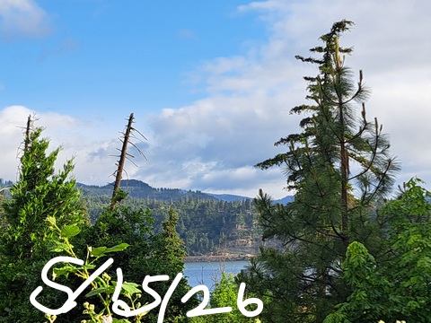
Glenwood this morning
Nothing special was happening to start Friday other than a beautiful spring morning: cloudy with drizzle west of Wyeth and partly cloudy to the east. Thanks to wind and cloud cover, Glenwood started the day at 44 degrees. Looking around the region, Parkdale was the lowest reading at 40F. In Lahsh, Tajikistan, temps rose to 120F yesterday, highest on the planet for the day!
Today’s Gorge weather forecast
We’ll see exactly half that many degrees in Hood River today; temps max out around 60F there with 64F in The Dalles and SIX-SEVEN degrees in the desert. After hovering to the NW during the day, a cold front moves in this evening. Rain starts up near Cascade Locks around 5pm and makes it as far east as Celilo Village by 8pm. Drizzle continues into Saturday morning. During this time, the snow level falls from 3500′ to 2500′ meaning a select few of you (Underwood, Willard, Snowden, High Prairie) could see “chunky rain” tonight into Saturday morning. Today’s wind: 15mph west of The Dalles all day building to 25-30mph from Avery east to Boardman this afternoon.
Saturday’s Gorge weather forecast
Saturday morning starts with drizzle as far east as Wishram, where the rams are wishing for rain, and the ewes are glad the rams are distracted. After 11am, rain pulls back to areas west of Underwood and lingers until 5pm or so. Thanks to surface heating and cold air aloft, all areas of the Gorge have a chance of surface-based thunderstorms Saturday afternoon into early evening. Temps start in the upper 30s to low 40s with clouds to the west and sun to the east. Afternoon highs range from the mid 50s (west) to low 60s (The Dalles) and mid 60s (The Desert). Wind starts with 5-10mph west of Avery and 15-20mph from Maryhill to Boardman. Afternoon wind rises to 10-15mph west of Lyle and 30mph from Lyle to Threemile Canyon. Given that we’ve already see a couple small wildfires, you’ll want to hold off on burn piles or other flame-infused activities on Saturday.
Sunday’s Gorge weather forecast
Things get interesting Saturday night into Sunday morning as the sky clears, the wind settles down (but doesn’t stop), and temps aloft fall to -2C or -3C. Dewpoints are forecast to be in the 27-38F range. Frost shouldn’t happen down low thanks to the high dewpoints – clouds will form before frost can. Away from the Nch’i Wana (Big River), the forecast is trickier and depends on cloud cover. Glenwood is likely to fall below 30F if it’s clear there. Centerville and Goldendale and The Dalles should be too windy for frost. Parkdale and Odell and Trout Lake are the big question marks due to uncertainty about cloud cover. Given the dewpoints, let’s rule out a hard freeze. 36F seems within reach simply due to the freezing level being at 2500′ and temps aloft below 0C. So…. be prepared.
For the rest of Sunday, we’ll have partly cloudy sky. East of The Dalles, instability lingers for a chance of afternoon thunderstorms. High temps range from 63F on the west side to 68F on the east side. West wind will be 15-20mph from Viento to Boardman in the morning. Afternoon wind rises to 25mph from Stevenson to Avery and falls below 15mph east of Rufus.
Extended Gorge weather forecast
Starting Monday, dry, stable weather returns along with plenty of sunshine. Temps slowly make their way back into the 70s. West wind continues all week long, stronger at times, and lesser at times. This will make the boardheads happy, if not the rest of y’all. Beyond next Saturday, uncertainty skyrockets. There’s some indication of a return to cooler weather to start the following week, but that’s pretty far out there to be making guesses about the weather. Happy gardening. Safe travels. -TATAS
HEY! DON’T STOP READING! Is this community-focused forecast helpful to you? It sure is! It takes me a couple hours a day to write. Please join your friends and neighbors in contributing to keep it going. Venmo: @thegorgeismygym PayPal: twomirrors@gmail.com USPS: Temira / PO Box 841 / Hood River, Oregon 97031 You can test out the forecast subscription for a few days for free by signing up below. Easy! Do it!
MT HOOD SNOW FORECAST

QR codes and links for end-of-season tips – thank you!!!
Cash/check: Temira – PO BOX 841 – Hood River, Oregon 97031


