

GORGE WIND FORECAST
If you’re still seeing yesterday’s and it’s after 9am, try opening this in an incognito window
SHORT-TERM gorge wind forecast
Hi friends! It’s Friday, TGIF, and it’s another breezy day in the Gorge! Westerlies of some sort are in the Gorge wind forecast today and tomorrow with lesser wind on Sunday. Monday looks rainy and not-windy. Westerlies return on Tuesday and Wednesday and probably Thursday before a warming trend impacts the PNW. Wind in that warm period depends on where exactly the hottest weather sets up, and that’s not yet decided. Hopefully the heat will end with “The Cooldown You Were Looking For.”
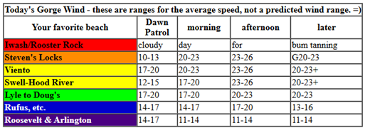
Friday started with pressures of 30.06/29.98/29.93 and an approaching weak weather system. Best chance for the Corridor (Viento to Hood River) will be this morning. You’ll probably have to shift east in the afternoon. Early wind was 10-13mph at Stevenson with 18-22mph all the way from Viento out to Arlington. Models give us a period of 21-24mph at the Hatch this morning prior to the wind dropping to 15-18mph from Stevenson to Mosier late morning. Out east, we’ll have 20-23mph this morning.
Afternoon wind builds to 26-29mph from Mosier to Hermiston, strongest in the Mosier-Rufus stretch. Models suggest the Hatch might get a nudge back to the 21-24mph range mid-afternoon as a trough moves towards BC and reinforces cool air on the west side. Executive session (after 5pm): 12-15mph from Stevenson to Mosier with 25-28mph from Lyle to Threemile and 17-20mph near Hermiston. River flow over the last 24 hours was 193-255kcfs, river temp is 61.3F, and high temp forecast is 67F in Hood River and 77F in the desert.
RIVER FLOW FOR SITES BETWEEN AVERY (EAST OF THE DALLES) AND RUFUS: CLICK HERE FOR JOHN DAY DAM FLOW.
RIVER FLOW FOR SITES BETWEEN STEVENSON AND DOUG’S BEACH (WEST OF THE DALLES): CLICK HERE FOR THE DALLES DAM FLOW

LONGER-TERM gorge wind forecast
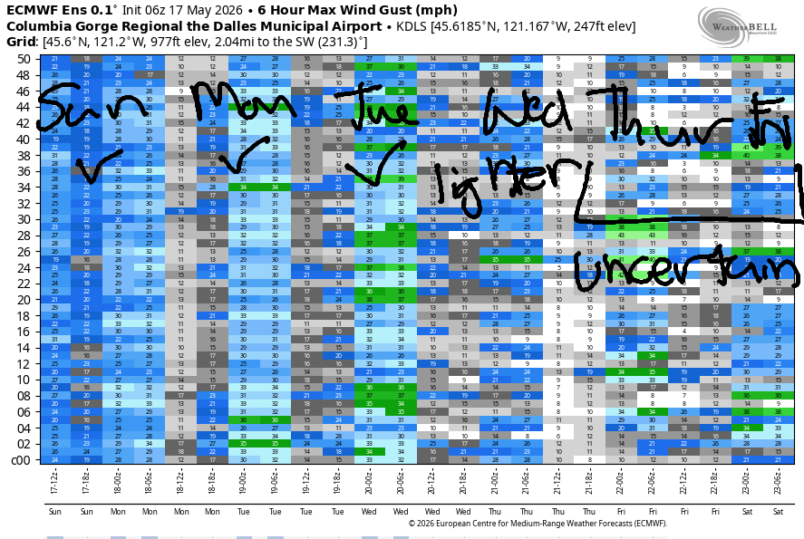
Saturday brings an active weather day as a trough (cool air) swings inland. Offshore, high pressure will build late in the day, but probably not early enough to help us out a ton. First things first: HRATS has a brushing party in Post Canyon. Meet at Family Man at 9am with your string trimmers and loppers. Morning wind will be 7-10mph between Stevenson and Avery with 15-18mph from Rufus to Hermiston. Areas east of Doug’s slowly build to 22-25mph, and areas west of Doug’s languish at 13-16mph with showery conditions. After 2pm, or perhaps after 5pm, as this system moves inland, areas between Lyle and Arlington rise to 26-29mph with Threemile to Hermiston climbing, after 5pm, to 23-26mph. High temps: 61F in Hood River with intermittent showers and 71F in the desert with partly cloudy sky.
Weak ridging builds inland on Sunday (SIX SEVEN DAY!!!). HRATS have a trail working party, brushing, specifically, meeting at Family Man at 9am. Early wind will be 14-17mph from Stevenson to Avery with 20-23mph from Maryhill to Hermiston. The wind fades during the day. Late in the afternoon or evening, if we get really, really lucky, there could be a blast of pre-frontal wind at the hatch ahead of an incoming weather system. Fingers crossed. High temps range form 69F in Hood River to 74F in the desert.
Monday looks rainy with light/variable wind. A weather system swings through on Tuesday and gives us a shot at mid to upper 20s. Transitional weather on Wednesday sets us up for a decent day at the Hatch – currently the forecast is 21-24mph, but that is likely to change. Beyond that…warming weather and lots of uncertainty about the wind. Hope to see you on the Nch’i Wana today! Have fun and be safe out there!

Was that helpful? I knew it was! Guess what? All of this crucial work – from your personal wind and snow reports to the invaluable TATAS updates – is made possible by my relentless efforts. Maintaining this labor of love isn’t easy. Each daily forecast takes hours. Website hosting, weather model access, and back-end admin work takes time and money. That’s where you come in.
YOUR CONTRIBUTION MAKES A DIFFERENCE
- SUPPORT ACCURATE, HYPER-LOCAL WEATHER FORECASTING
- ENABLE ACCESS FOR ALL, EVEN THOSE WITH LESS MEANS
- SUPPORT A COOL HUMAN WHO WORKS HARD SO YOU CAN PLAY
Take a moment to click one of the buttons below. Donate $19.99 or more (how much does this forecast enhance your life?) and get the email in your inbox. Whether it’s a renewing subscription (auto-renew) or a one-time donation, every contribution makes a real difference. Help me keep this labor of love alive, so we can all continue playing, commuting, and living in the Gorge with peace of mind and the best weather forecasts possible. Thank you!


Hood River, Oregon 97031


JONES BEACH, SAUVIE ISLAND, & COAST FORECAST
Wind northerly unless otherwise indicated. For coast, it’s North/Central/South with the “central” at approximately Florence. Swell forecast from NWS for central coast. Jones: westerly unless otherwise stated. Sauvie Island: northerly unless otherwise stated.
Coast Friday: W5-10/LTW/N15-20, SW swell 2′ @ 18 and W 6′ @ 12. Saturday: Variable to 15/V to 10/N15-20, W 6′ @ 10 and SW 2′ @ 17. Sunday: SW 15-20/LTW/LTV, W 5′ @ 9 and SW 2′ @ 16. Jones Friday: LTV. Saturday: 7-10. Sunday: LTW. Sauvie Island Friday: 5-10. Saturday: W 10-15. Sunday: LTV.
BARE BONES HOOD RIVER WEATHER FORECAST
Partly cloudy all day. Temps start in the mid 50s and rise to the SIX-SEVEN degrees. Moderate westerlies. No rainbows. Saturday will be cloudy with light drizzle possible in the morning and a few showers in the afternoon. Temps start in the mid 40s and rise to the low 60s. Light to moderate westerlies. 47% chance of rainbows. Sunday will be cloudy then clear then high overcast. Temps start in the low 40s and rise to the upper 60s. Moderate westerlies. No rainbows.
TEMIRA’S AWESOME TRAVEL ADVISORY SERVICE
HYPERLOCAL WEATHER FORECAST FOR THE COLUMBIA GORGE
THE DALLES, HOOD RIVER, WHITE SALMON, TROUT LAKE, STEVENSON, CASCADE LOCKS, PARKDALE, ODELL, HUSUM, BZ, MILL A, WILLARD, GOLDENDALE, RUFUS, ARLINGTON, boardman
Good morning, neighbors! Junuary persists for a good portion of the next week with warming forecast at the end of next week. Intermittent rain is possible through Tuesday with the heaviest rain Sunday night into Tuesday morning. Models don’t quite agree on how much rain we’ll see, but you’re probably going to want a parka as well as Parka (or RainGuard) if your cherries are approaching the stage where rain is problematic. Monday’s rain will be accompanied by highs from 65-76 and near-zero wind with clouds in the morning and sun in the afternoon. Hope that info helps!
Our friends around the world this morning and the !ce report
Looking at our friends and human family this morning… Glenwood started the day at 52 degrees. Looking around the world at our friends being threatened by the current US administration: Tehran is 83 degrees, sunny, with 24% humidity; Havana is 83F, partly cloudy, chance of thunder, and 7% humidity – MUGGY!; Muscat, Oman is 95 degrees, sunny, 57% humidity, and has a forecast low of 88F – brutally hot and muggy; finally, Caracas, Venezuela will be 74F, cloudy, and 80% humidity, also quite muggy. Nuuk, Greenland, is forecast to be 40F today with 82% humidity and cloudy sky. !CE report: they kidnapped someone in The Dalles yesterday down the road from NORCOR. Fuera la migra! Stay safe, neighbors!
Today’s Gorge weather forecast
Around here – really nice weather! Expect partly cloudy sky west of Mosier all day with clear sky to the east. West wind will be 15-20mph from Stevenson to the Arlington Triangle this morning. Afternoon wind will be 25-30mph from Mosier to Hermiston with 15-20mph west of Mosier.
Saturday’s Gorge weather forecast
Friday night sees a trough of cooler air coming our way, which sets us up for a cool, cloudy, drizzly Saturday. It brings drizzle for areas west of Mosier with a brief bout of light sprinkles possible as far east as The Dalles between 2am and 5am. Morning temps will be in the mid 40s under cloudy sky. Snow level: 4000′ – keep this in mind if you’re planning hiking or biking at elevation. Maybe tone it down a bit and come down to the lowlands! Afternoon sees partly cloudy sky persist all the way into the eastern desert. West of Hood River, drizzle and showers stick around. It’s possible we could see pop-up showers or thunderstorms scattered about the entire region. High temps range from 60F in Stevenson to 66F in The Dalles and 71F in the desert. Wind will be 5-10mph west of Rufus to start the day with 15-20mph from Rufus eastward. Afternoon: 15mph west of Lyle and 25-30mph from Lyle to Arlington and eventually out to Hermiston.
Sunday’s Gorge weather forecast
A weak ridge arrives on Sunday and briefly dries us out. The day starts with clouds to the west and clear sky to the east with 15-20mph west wind. Temps at 5000′ will be around +2C which puts Glenwood and Dufur at risk of frost and the Upper Hood River Valley in the 36-40F range if the sky is clear there. Clouds dissipate midday before a shield of high clouds arrives from the west ahead of the next system. Highs: 69-74F in the lowlands.
Extended Gorge weather forecast
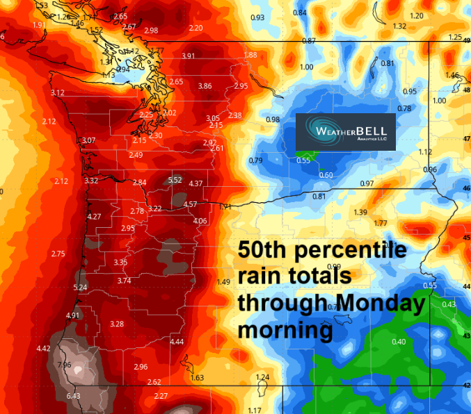
A much wetter system is forecast Sunday night into Monday. Snow level: 6500′. This one is likely to bring steady rain all the way east into the desert. Quantity isn’t quite clear, but you can look at the 50th percentile rainfall map through Wednesday 5am to get a sense of what’s coming. We’ll have clouds and rain Monday morning and sun Monday afternoon with highs from 68-76F and light/variable wind. Showers are possible all the way into Tuesday night. On Wednesday, cool weather sticks around, but it should be mostly dry. Warming arrives Thursday and continues into the early part of the following week (or longer?). The amplitude of the warming isn’t clear yet – models take us to the 85-90F range by next Saturday. We’ll be keeping a close eye on this. As if we don’t keep a close eye on the weather every day! Safe travels. -TATAS
HEY! DON’T STOP READING! Is this community-focused forecast helpful to you? It sure is! It takes me a couple hours a day to write. Please join your friends and neighbors in contributing to keep it going. Venmo: @thegorgeismygym PayPal: twomirrors@gmail.com USPS: Temira / PO Box 841 / Hood River, Oregon 97031 You can test out the forecast subscription for a few days for free by signing up below. Easy! Do it!
MT HOOD SNOW FORECAST

QR codes and links for end-of-season tips – thank you!!!
Cash/check: Temira – PO BOX 841 – Hood River, Oregon 97031


Leave a Reply