

GORGE WIND FORECAST
If you’re still seeing yesterday’s and it’s after 9am, try opening this in an incognito window AND/OR FLUSHING YOUR CACHE or do a do a hard refresh (Ctrl+Shift+R / Cmd+Shift+R)

SHORT-TERM gorge wind forecast
Hi friends! Another windy day is on tap today! Somewhat lighter westerlies stick around Sunday and Monday before the wind jumps in response to a cooling trend Tuesday and Wednesday. High temps for this holiday weekend will slowly climb from 80 to 90. Stay hydrated! For those of you new to the forecast, a little orientation – the forecast predicts what the iWind/iKite sensors will read. Sensors east of The Dalles tend to read high compared to the Swell sensor. In other words, 30 at Swell is not equal to 30 at Rufus. 30 at Swell is equal to perhaps 36 at Rufus, and 30 at Rufus is equal to perhaps 20-23ish at Swell. Hope that helps and doesn’t confuse!
Saturday started with pressures of 30.10/30.00/29.97 for gradients of 0.10/0.03. Low clouds were present west of Hood River. They are forecast to burn off this afternoon, but the desert will have a solid head start on heating. Early wind was 17-20mph from Viento to Hood River with under 10mph everywhere else. By late morning, we’ll have 20-23mph from Stevenson to Mosier, 13-16mph near Rowena, and 10-13mph east of The Dalles.
A weak system approaches WA during the morning and moves inland in the afternoon. Prior to that, we could see a mid to late morning lull. After that, say after 2pm, strong offshore high pressure rebuilds, and the desert heat low lends a hand. This gives us 22-25mph from Stevenson to Mosier (Hatch may under-perform with gusty 17-20), and 24-27mph from Lyle to Rufus. Arlington will be right on the edge and may only reach 20-23mph. Threemile eventually rises to 14-17mph. River flow over the last 24 hours was 149-217kcfs, river temp is 65.8F, and high temp forecast is 83F in Hood River and 90F in the desert.
RIVER FLOW FOR SITES BETWEEN AVERY (EAST OF THE DALLES) AND RUFUS: CLICK HERE FOR JOHN DAY DAM FLOW.
RIVER FLOW FOR SITES BETWEEN STEVENSON AND DOUG’S BEACH (WEST OF THE DALLES): CLICK HERE FOR THE DALLES DAM FLOW

LONGER-TERM gorge wind forecast
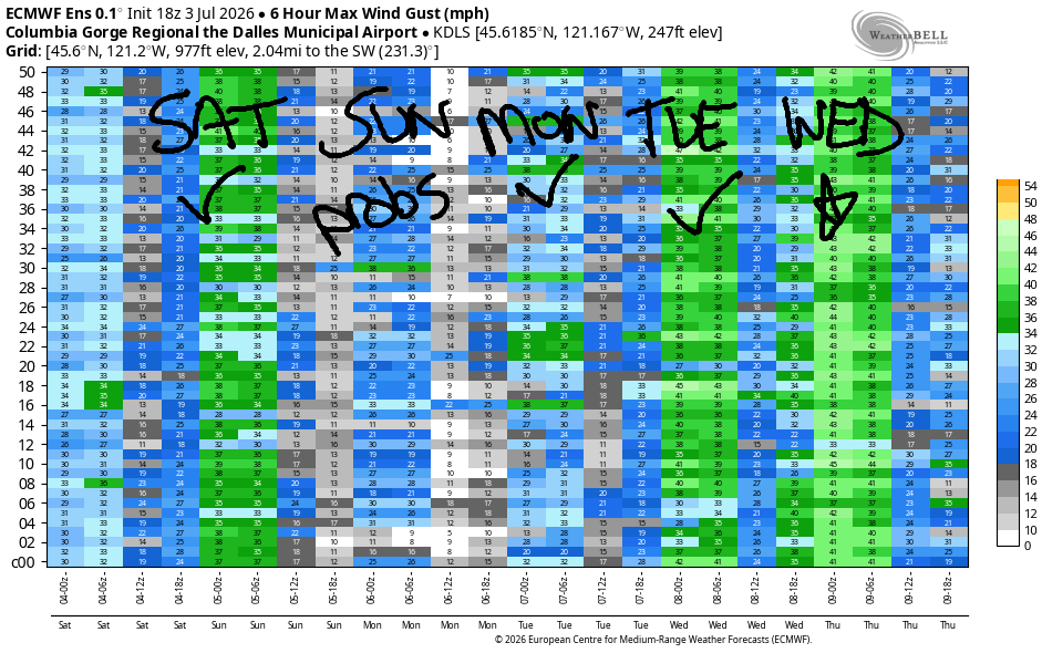
On Sunday morning, CGW2 has a swap meet down on the Big Dirt Port Lot at the Hood River Waterfront. Weather-wise, Sunday starts with low clouds to the west and clear sky to the east. Moderately strong offshore high pressure lingers, and a desert heat low forms in the afternoon. Models suggest light wind, but this is a setup where the models often under-predict the wind. Let’s call it dawn patrol at 18-21mph from Viento to the Hatch with 18-21mph from Stevenson to Hood River (15-18mph at Mosier) for the rest of the day. High temp: 88F in Hood River.
Monday sees a low approaching BC with cooler air dropping down the coast late in the day. Will it be early enough to have an impact? Maybe… The day starts with 18-21mph from Viento to the Hatch and fills in from Stevenson to Mosier midday. Afternoon brings 20-23mh from Stevenson to Doug’s (gusty 17-20mph at the Hatch) into the evening. East of The Dalles, the wind stays light and variable into the evening. High temp: 91F in Hood River.
Atmospheric shenanigans increase on Tuesday, but the temp gradient from west to east increases too! As of this morning, we’re looking at 26-29mph or more all the way from Stevenson to Arlington and beyond. The moving pieces continue to affect wind quality on Wednesday. Even so, ensembles give us 28-32mph, probably strongest from Lyle to Rufus in the morning and all the way from Mosier to Threemile in the afternoon After Wednesday, uncertainty skyrockets, but west wind is likely to continue. See you on the Nch’i Wana soon!

Was that helpful? I knew it was! Guess what? All of this crucial work – from your personal wind and snow reports to the invaluable TATAS updates – is made possible by my relentless efforts. Maintaining this labor of love isn’t easy. Each daily forecast takes hours. Website hosting, weather model access, and back-end admin work takes time and money. That’s where you come in.
YOUR CONTRIBUTION MAKES A DIFFERENCE
- SUPPORT ACCURATE, HYPER-LOCAL WEATHER FORECASTING
- ENABLE ACCESS FOR ALL, EVEN THOSE WITH LESS MEANS
- SUPPORT A COOL HUMAN WHO WORKS HARD SO YOU CAN PLAY
Take a moment to click one of the buttons below. Donate $19.99 or more (how much does this forecast enhance your life?) and get the email in your inbox. Whether it’s a renewing subscription (auto-renew) or a one-time donation, every contribution makes a real difference. Help me keep this labor of love alive, so we can all continue playing, commuting, and living in the Gorge with peace of mind and the best weather forecasts possible. Thank you!


Hood River, Oregon 97031


JONES BEACH, SAUVIE ISLAND, & COAST FORECAST
Wind northerly unless otherwise indicated. For coast, it’s North/Central/South with the “central” at approximately Florence. Swell forecast from NWS for central coast. Jones: westerly unless otherwise stated. Sauvie Island: northerly unless otherwise stated.
Coast Saturday: 15/20-25/30-35, NW swell 4′ at 7 seconds. Sunday: 20-25/20-25/25-30, W 4′ @ 14. Monday: 15-20/15-20/20-25, NW 5′ @ 12 and SW 2′ @ 16. Jones Saturday: 16-19. Sunday: 21-24. Monday: 23-26. Sauvie Island Saturday: 12-15. Sunday: 15-18. Monday: 10-13.
BARE BONES HOOD RIVER WEATHER FORECAST
Sunny today. Temps start in the low 60s and rise to the low 80s. Moderate westerlies becoming moderately strong. No rainbows. Sunday will be clear then partly high cloudy. Pretty sunset. Temps tart in the low 50s and rise to the upper 80s. Moderate westerlies. No rainbows. Monday will be sunny. Temps start in the mid 50s and rise to the low 90s. Moderate westerlies. No rainbows.
TEMIRA’S AWESOME TRAVEL ADVISORY SERVICE
HYPERLOCAL WEATHER FORECAST FOR THE COLUMBIA GORGE
THE DALLES, HOOD RIVER, WHITE SALMON, TROUT LAKE, STEVENSON, CASCADE LOCKS, PARKDALE, ODELL, HUSUM, BZ, MILL A, WILLARD, GOLDENDALE, RUFUS, ARLINGTON, boardman

Good morning, neighbors! It’s Independence Day 2026, and today we celebrate a nation of immigrants. Today is a good day to work towards the “liberty and justice for all” line from the Pledge of Allegiance. Today’s a good day to work for the removal of the slavery exclusion in the 13th Amendment. Today’s a good day to remember that we’ve been a nation of hard-working immigrants from day 1. It’s also a day to remember our legacy of slavery and land stolen from indigenous peoples. Our nation’s past is complicated and, at times, breathtakingly unkind. Today is a good day to commit to doing better going forward, to acting out of love, not hatred, of acting out of compassion, not greed.
“Hatred does not cease by hatred; hatred ceases only by love. This is the eternal law.” -Dhammapada 5
As of 6:50am, there are no signs of icy roads in Hood River.
Weather for our friends in Glenwood and around the world
On to the weather… Our friends in Glenwood started with 44 degrees this morning, which might be a bit chilly for milking the cows, but is great sleeping weather. Maybe they slept in later than I did? I woke up at 4:45 (it wasn’t feline insomnia this time) and got up at 5:15. Not sure why I’m sharing this. Anyway, everyone in Glenwood is happy they’re not hanging out with our friends in some of these places today:
Bandar-e Mahshahr, Iran: 109, sunny, 20% humidity
Havana, Cuba: 81, partly cloudy, 83% humidity
Muscat, Oman: 90, sunny, 75% humidity
Caracas, Venezuela: 71, cloudy, chance of thunder, 88% humidity
Nuuk, Greenland: 44, partly cloudy, 90% humidity
Gaza City: 87, sunny, 59% humidity
Ottawa, Canada: 71, partly cloudy, 69% humidity
Here in the Gorge, we have a Red Flag Warning posted for many areas due to heat, wind, low humidity, and dry fuels. Yesterday someone started a wildfire near Crawford Oaks State Park. That one quickly grew to 384 acres and is now 80% contained. Today’s fire danger is higher – if you see something (fireworks, trailer chains dragging, people tossing cigarette butts), do something and say something!
Temps for your holiday activities end up near 80 in Stevenson, 83 in Hood River, 88 in The Dalles, and 93 way out in the desert. The differential combines with offshore high pressure and morning clouds to the west for west wind at 20-25mph between Stevenson and Mosier all day with 25-30mph from Lyle to Rufus in the afternoon. At the Arlington Triangle, westerlies rise to 20-25mph late in he day. Sky: clear for all by afternoon.
Sunday’s Gorge weather forecast
On Sunday, low clouds return to areas west of Hood River for a few hours in the morning. To the east: clear. High clouds (a few, anyway) arrive in the afternoon, just in time for a pretty sunset while I eat tref foods at my friend John’s house. Morning temps on Sunday will be in the 45-55 range. Afternoon highs range from 84 in Stevenson to 88 in Hood River and the low 90s form The Dalles eastward. Wind will be 20mph pretty much all day between Viento and Mosier with low teens near Hood River and light/variable wind to the east.
Monday’s Gorge weather forecast
Even warmer weather is forecast on Monday after a 45-55 degree start. Afternoon highs will be 88 in Stevenson, 91 in Hood River (too hot for TATAS) and 97 in The Dalles. Wind will be 20mph most of the day from Stevenson to Mosier with 20mph from Stevenson to Murdoch in the evening. Eastern Gorge: light and variable and hot all day.
Extended Gorge weather forecast
A cooling trend arrives on Tuesday with highs from 82-98. That huge differential gives us west wind at 25-35mph. We lose 5-10 degrees of heat on Wednesday, add some low clouds west of Hood River, and continues with strong westerlies. Beyond Wednesday, models hint at a warming trend, but there’s quite a bit of uncertainty, so I’ll leave it here for now. Safe travels. -TATAS
HEY! DON’T STOP READING! Is this community-focused forecast helpful to you? It sure is! It takes me a couple hours a day to write. Please join your friends and neighbors in contributing to keep it going. Venmo: @thegorgeismygym PayPal: twomirrors@gmail.com USPS: Temira / PO Box 841 / Hood River, Oregon 97031 You can test out the forecast subscription for a few days for free by signing up below. Easy! Do it!
MT HOOD SNOW FORECAST

QR codes and links for end-of-season tips – thank you!!!
Cash/check: Temira – PO BOX 841 – Hood River, Oregon 97031

