

MT HOOD SNOW FORECAST

QR codes and links for end-of-season tips – thank you!!!
Cash/check: Temira – PO BOX 841 – Hood River, Oregon 97031


Hey skiers and snowboarders! Thank you so much for using this forecast all winter. I’m betting all of us wished for more snow. Hopefully this forecast helped you make the most of the snow we received. If it was helpful, please consider making an end-of-season tip to support me and all the work I put in to making your life more fun!
If you don’t use electronic payments, you can send cash or check to: Temira / PO Box 841 / Hood River, Oregon 97031
THANK YOU FOR YOUR SUPPORT!!! HAVE A GREAT SUMMER!!!
Sign up to try out the year-round forecast for wind, snow, and everything else!
GORGE WIND FORECAST
If you’re still seeing yesterday’s and it’s after 9am, try opening this in an incognito window
SHORT-TERM gorge wind forecast
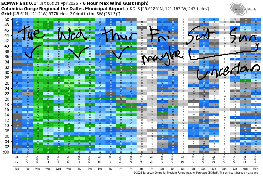
Hi friends! Interesting and very active and potentially very windy weather is on tap for the next few days. All that activity is going to have an impact on wind quality and reliability; I’d say the most reliable day (but probably not the windiest) will be Thursday. Let’s take a look:
Tuesday started with pressures of 29.83/29.73/29.68 for gradients of 0.10/0.05. A weather system is going to move inland this morning and bring some rain to the west side. For the morning hours, we’ll have gusty 17-20mph from Viento to the Hatch with 5-10mph at Stevenson and 10-13mph east of Mosier to Arlington. As this system moves inland, we’re likely to see a short burst of strong wind ahead of it and then a drop to gusty 14-17mph as the rain moves in; rain eventually makes it as far east as Rowena. While areas west of The Dalles will be dropping, areas to the east will be rising. Between Avery and Threemile, we’ll eventually see gusty 28-32mph. After 2pm, speeds start dropping. River flow over the last 24 hours was 185-234kcfss (218-225kcfs at Rufus), river temp is 51.1F, and high temp forecast is 64F.
RIVER FLOW FOR SITES BETWEEN AVERY (EAST OF THE DALLES) AND RUFUS: CLICK HERE FOR JOHN DAY DAM FLOW.
RIVER FLOW FOR SITES BETWEEN STEVENSON AND DOUG’S BEACH (WEST OF THE DALLES): CLICK HERE FOR THE DALLES DAM FLOW

LONGER-TERM gorge wind forecast
Wednesday looks wild, weather-wise. We have a cold front moving inland and a compact low moving inland as well. Way out in Montana, a heat low contributes, as does offshore high pressure. That low moving inland is going to send wraparound rain into the Gorge. TJ’s Dawn Patrol looks like gusty 21-24+ from Stevenson to Doug’s (probably way stronger at Viento) with 30-33mph from Avery to Hermiston. Complications arise late morning or early afternoon with the arrival of wraparound rain. While the gradients will be massive, the rain could impact performance. The GFS deterministic calls for absolutely nuking westerlies in the afternoon east of The Dalles with mid to upper 20s at the Hatch. The Euro is far less optimistic and calls for upper 20s to low 30s. Generally speaking, more rain will equal less wind, and less rain will equal more wind. Expect very gusty conditions. High temp for Hood River: 56F. Desert: 60F.
“Classic Gorge Setup” is in the cards on Thursday: offshore high pressure, a trough along the coast, and sunshine in the desert. The day starts with 16-19mph from Viento to Mosier. Afternoon wind rises to 21-24mph from Stevenson to Hood River with 28-31mph from Mosier to Arlington. High temp: mid 60s with clouds in Hood River in the morning and sun in the afternoon.
Friday starts calm and builds to W 14-17mph. Light easterlies are forecast (for now, anyway), on Saturday. Beyond that, model uncertainty increases. I’ll be gone from Friday through the 7th of May on retreat. I wish you many big days on the Nch’i Wana while I’m gone, and I look forward to forecasting for you all summer!

Was that helpful? I knew it was! Guess what? All of this crucial work – from your personal wind and snow reports to the invaluable TATAS updates – is made possible by my relentless efforts. Maintaining this labor of love isn’t easy. Each daily forecast takes hours. Website hosting, weather model access, and back-end admin work takes time and money. That’s where you come in.
YOUR CONTRIBUTION MAKES A DIFFERENCE
- SUPPORT ACCURATE, HYPER-LOCAL WEATHER FORECASTING
- ENABLE ACCESS FOR ALL, EVEN THOSE WITH LESS MEANS
- SUPPORT A COOL HUMAN WHO WORKS HARD SO YOU CAN PLAY
Take a moment to click one of the buttons below. Donate $19.99 or more (how much does this forecast enhance your life?) and get the email in your inbox. Whether it’s a renewing subscription (auto-renew) or a one-time donation, every contribution makes a real difference. Help me keep this labor of love alive, so we can all continue playing, commuting, and living in the Gorge with peace of mind and the best weather forecasts possible. Thank you!


Hood River, Oregon 97031


BARE BONES HOOD RIVER WEATHER FORECAST
Increasing clouds today with drizzle possible midday. Temps start in the mid 50s and rise to the mid 60s. Moderate westerlies. 96% chance of rainbows. Wednesday starts cloudy and turns rainy. Temps start in the mid 40s and rise to the mid 50s. Moderately strong to strong westerlies. 99% chance of rainbows. 93% chance of double rainbows. Thursday will be mostly cloudy then mostly clear. Temps start in the low 40s and rise to the mid 60s. Moderate to moderately strong westerlies. No rainbows.
TEMIRA’S AWESOME TRAVEL ADVISORY SERVICE
HYPERLOCAL WEATHER FORECAST FOR THE COLUMBIA GORGE
THE DALLES, HOOD RIVER, WHITE SALMON, TROUT LAKE, STEVENSON, CASCADE LOCKS, PARKDALE, ODELL, HUSUM, BZ, MILL A, WILLARD, GOLDENDALE, RUFUS, ARLINGTON, boardman
Good morning, neighbors! Active weather impacts the Gorge for the next few days. We’re all likely to see rain on Wednesday. Strong wind is in the cards for at least some of us for the next three days. Things calm down on Friday (bye for two weeks!) and look to stay rather uneventful with mild temps and limited precipitation into early May.
Glenwood this morning
Fun things are happening to start the day. First off, despite sunshine in much of the Gorge, it’s pouring in Portland! In Glenwood, it’s was 45 degrees to start. Hood River was in the mid 50s (WOW! WARM!) just shy of the all-time record high-low for 4/21: 56F. No record. SAD.
Today’s Gorge weather forecast
Portland gets tired of the rain late morning and sends it our way. We’ll see drizzle as far east as The Dalles or perhaps Wishram for a few hours. Afternoon: mostly cloudy and breezy. Highs range form 64F (west side) to SIX-SEVEN degrees (The Dalles), and 78F (Pasco). When there’s a temp gradient of that size, wind is almost guaranteed! Wind today: 15-20mph west of Avery and 25-35mph from Avery to Hermiston.
Wednesday’s Gorge weather forecast
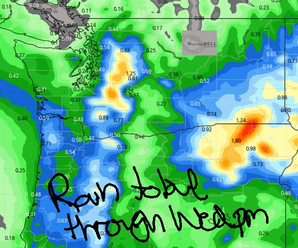
A low pressure system moves inland on Wednesday along with a cold front. Exciting things happen! First off, we start the day with temps in the mid 40s down low and upper 30s up high. As the low moves inland, it sends wraparound moisture all through the region starting a few hours prior to dawn. Heaviest rain will be east of The Dalles (see image for rain totals), but the rain eventually wraps around to the west side mid-morning. Accompanying the rain will be wind: 20-30mph west of The Dalles and 30-40mph east of The Dalles. Caveat: sometimes pouring rain can shut down wind, so who actually knows. Of major importance is the impact of wind on tumbleweeds: once soaked, their takeoff speed is higher, so if you’re planning to head to the tumbleweed races, be prepared for a poor showing. High temps max out in the mid 50s (west), right around 60F (The Dalles), and low 60s (the desert). Up in the mountains, the snow level will be around 4000′ with a little snow possible. More notable: very strong wind at pass level.
Extended Gorge weather forecast
We can’t totally rule out frost on Thursday morning as 850mb temps drop into the low single digits. We’ll look more closely tomorrow morning. The day starts with clouds to the west and sun to the east and west wind at 15-20mph all through the Gorge. By afternoon, we’ll have mostly sunny sky everywhere with west wind at 20-25mph west of Mosier and 25-35mph east of Mosier all the way to Arlington’s Triangle. Highs will be in the mid 60s on the west side and SIX-SEVEN degrees in Pasco.
Beyond that… 65-70ish degrees weather is forecast for much of the extended forecast. We will want to keep an eye on frost chances Saturday morning as clear sky, east wind, lowish dewpoints, and cool temps aloft combine for good radiational cooling conditions. Safe travels. -TATAS
HEY! DON’T STOP READING! Is this community-focused forecast helpful to you? It sure is! It takes me a couple hours a day to write. Please join your friends and neighbors in contributing to keep it going. Venmo: @thegorgeismygym PayPal: twomirrors@gmail.com USPS: Temira / PO Box 841 / Hood River, Oregon 97031 You can test out the forecast subscription for a few days for free by signing up below. Easy! Do it!
JONES BEACH, SAUVIE ISLAND, & COAST FORECAST
ON WINTER VACATION UNLESS DESPERATELY NEEDED.